Table of Contents
Advertisement
Quick Links
Advertisement
Table of Contents

Subscribe to Our Youtube Channel
Related Manuals for iGage iG5


Summary of Contents for iGage iG5
- Page 1 Static GNSS Receiver User Manual Revision V 2021.03.23...
-
Page 2: Copyright, Control And Safety
Windows is a registered trademark of Microsoft Corporation. Bluetooth® is a registered trademark of Bluetooth SIG, Inc. GNSS Safety Warning The iG5 GNSS receiver tracks and utilizes signals from many space-based satellite navigation systems: The Global Positioning System (GPS) is operated by the US Government which is solely responsible for the accuracy and maintenance of the GPS network. -
Page 3: Fcc Compliance
United States. FCC Notice iG5 receivers comply with the limits for a Class B digital device, pursuant to the Part 15 of the FCC rules when it is used in the Portable Mode. - Page 4 User Manual...
-
Page 5: Table Of Contents
Collecting Static Data ..............20 Downloading, Processing and Archiving Data ......21 Installing the Download Tool ............ 21 Connecting the iG5 Receiver to your Computer ..... 22 Starting the iGx Download Tool..........23 Downloading Data ..............23 Submitting an Occupation to OPUS ......... 25 Setting the Receiver Type ............ - Page 6 Semi-Trucks and Trains ............63 Large Structures to the South ..........64 Huge Trees to the South ............65 Huge Trees Overhead ............. 65 Large Reflective Surfaces Nearby........... 66 Deep Canyons ................. 67 Power Poles ................68 iG5 User Manual...
-
Page 7: Introduction
#12 Why does Modern RTK work where OPUS fails? ... 74 #13 Fresnel Zone Considerations ........... 75 Conclusion ................. 77 Connecting the iG5 to a PC or Smartphone via Wi-Fi ....79 Turning the Wi-Fi ON .............. 79 Connecting to the Wi-Fi ............79 Setting the Recording Rate and Settings ....... -
Page 8: Technical Specifications
Your input is extremely valuable to us and we will listen to your suggestions! Software updates and news are available from: www.iGGPS.com Click on ‘Tools’ for firmware, FAQs and other iG5 information. Don’t hesitate to call iGage for assistance deploying, using or updating your device. Remote assistance is available. Technical Specifications... -
Page 9: The Really-Quick-Start Guide For Static Operation
Install the download tool from the included thumbdrive or get the latest version from www.iGGPS.com. Turn on the receiver, wait 10-seconds for the power LED to flash and then plug your iG5 into a USB connector on your computer. iG5 User Manual... - Page 10 You will need to manually select the correct antenna type. Click anywhere in the ‘antenna’ selection box: Then in the drop-down selection box: Enter ‘IG5”, wait a moment for the list to populate and then click on the ‘IGAIG5 NONE’ selection to choose the correct antenna model.
-
Page 11: Important! Exporting To Other Programs (Not Opus)
Again, Galileo, GLONASS and BeiDou are removed and the files are decimated to even 15-second intervals! If you are using the iG5 occupation file in another application select the ‘Configuration’ tab, then choose 'Show Advanced Settings = Normal’ (or Advanced). -
Page 12: What's In The Ig5 Box
What’s in the iG5 Box? Other than a suitable tripod or pole, iG5 receivers are sold as complete kits, ready to record OPUS compatible static raw data sets. Each receiver kit includes these items: A Hard-Shell Carry Case iG5 GNSS Head... -
Page 13: Technical Assistance
Service is provided by iGage Mapping Corporation in Salt Lake City Utah. Safety Information This manual describes the iG5 GNSS Receiver. Before you use your receiver, please make sure that you read and understand these warnings and safety requirements. Warnings and Cautions An absence of specific alerts does not mean that there are no safety risks involved. -
Page 14: Use And Care
DO NOT leave the iG5 or accessories inside a vehicle in the summer. Temperatures higher than 160°F will permanently reduce battery capacity and battery life. -
Page 15: Battery Safety And Disposal
Battery Safety and Disposal The internal batteries are lithium-ion type cells. When they wear out, the receiver must be returned to iGage for replacement. Battery Warnings WARNING - Do not damage the rechargeable Lithium-ion battery. -
Page 16: Battery Charging
Radio Notices FCC Notice: iG5 GNSS receivers comply with the limits for a Class B digital device, pursuant to the Part 15 of the FCC rules when it is used in the Portable Mode. -
Page 17: Bluetooth Radio
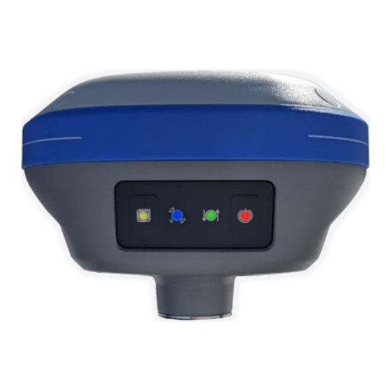
The receiver’s front panel has two pushbuttons Power and Record. On/Off Pushbutton Press the Power button (right-hand) for 3-seconds and release to turn the receiver ON. If the receiver is ON, press the Power button for 3-seconds to turn the receiver OFF. iG5 User Manual... -
Page 18: Files Pushbutton
When the receiver turns on, all four LED’s will light for ½ second. Files Pushbutton iG5 receivers are factory configured to automatically begin recording after the receiver is turned on and tracking satellites. (You probably won’t ever need to use the Files button.) -
Page 19: Secret Reset Mainboard Mode
Power button 5-times. This will initialize the OEM receiver engine. Recording Rate The iG5 receiver is configured to automatically record raw files with a 1 Hz rate. The receiver has 6,741,970,900 bytes available for user observation files. The receiver will generate approximately 14... -
Page 20: Collecting Static Data
PID (Point ID, Mark Name) Description Turn on the receiver. After 30 to 90-seconds, check that 5 or more satellites are tracked (the blue LED will blink 5 or more times.) The amber “Files” LED will begin to flash iG5 User Manual... -
Page 21: Downloading, Processing And Archiving Data
10. Make a note of the end time in your field book. Downloading, Processing and Archiving Data Your iG5 GNSS receiver includes a download, preprocessing and archive tool called iGx Download for use with the NGS OPUS, RTX, AUSPOS and IBGE online products. -
Page 22: Connecting The Ig5 Receiver To Your Computer
Computer Summary: Turn on the GPS, wait for 60-seconds; plug in the USB Cable to your computer. The iG5 receiver mounts just like a USB thumb drive (flash drive) on your Windows computer. No special drivers are required. To download data from your receiver: Turn on the GPS receiver Wait 60 seconds for the iG5 receiver to fully boot. -
Page 23: Starting The Igx Download Tool
Windows XP, Windows Vista, Windows 7, Windows 8 and Windows 10. If your iG5 receiver does not mount or an error message is displayed, you can usually unplug the receiver, wait a moment, then plug it back in. - Page 24 Description A longer description of the point. Note that quotes “ and ‘ are not allowed in the description. HI The Instrument Height which is the distance from the ground mark to the bottom of the receiver iG5 User Manual...
-
Page 25: Submitting An Occupation To Opus
Once all of the new occupations have downloaded you can submit an occupation to NGS OPUS, NGS OPUS-RS, RTX, AUSPOS. IBGE or post-process them using other software / services. Click on an occupation to select it: Click on the 'Submit to OPUS' button: iG5 User Manual... - Page 26 ‘Antenna Type’, the ‘Antenna Height’ and the ‘Email address.’ Next the program will prompt you with instructions for automatically entering the Zipped observation file name into the browse dialog: iG5 User Manual...
- Page 27 You will need to manually select the correct antenna type. Click anywhere in the ‘antenna’ selection box: In the drop-down selection box: Enter ‘IG5” and then click on the ‘IGAIG5 NONE’ selection to choose the correct antenna model. The NGS OPUS Submission form will be ready to submit, check the entries and any extended options that you might want to use.
-
Page 28: Setting The Receiver Type
Viewing the Observation Log (Hidden when Simple) A detailed log is automatically kept for the files that you download and submit for processing. Pressing the ‘Log’ button shows the log file for the currently selected observation: iG5 User Manual... -
Page 29: Trimming Occupation Files
The observation extends 5-minutes past midnight UTC, you don’t want to wait an extra day to process. Trim 6 minutes from the end of the file. Clicking the ‘?’ button to the right of the trim dialog displays helpful instructions: iG5 User Manual... -
Page 30: Performing Quality Control
Guide for TEQC from the UNAVCO web site. TEQC is a great tool for evaluating both the receiver’s performance and the site suitability for collected data. We use this QC function to verify receiver operation in our hardware validation process. iG5 User Manual... -
Page 31: The Mss Factory Support Button
The MSS Factory Support Button If you contact iGage for support, the technician may ask to view your computer screen remotely. Clicking the MSS button will download a support tool and provide a passcode that you can read to the technician who will then be able to view your screen and assist with issues. -
Page 32: Base Project Folder
If you change ‘Show Advanced Settings’ from ‘Simple’ to ‘Normal’, ‘Support OPUS Projects’ or ‘Advanced’ additional setup values are shown: You can change the rest of the configuration values as needed. Here are detailed descriptions for each of them: 'Base Project Folder' (Hidden when Simple) iG5 User Manual... -
Page 33: Archive All Projects
There are similar Archive buttons on the main page: one archives the current occupation and the other archives the entire current project. The download tool does not provide a method to restore these backups, however they are standard ZIP files and the iG5 User Manual... -
Page 34: Gps Mounts On Drive
‘Update GPS Model’ button to display this dialog: Use the drop down ‘Receiver Model’ to change the receiver type. If the HCN Key has been lost, you will find it on a white sticker inside the battery compartment. iG5 User Manual... -
Page 35: Minimum File Size To Transfer
HI for each individual occupation later, this is just the default. If you ALWAYS use a 2-meter range pole, then this value will always be 2.000 and you won't have to worry about HI blunders. iG5 User Manual... -
Page 36: Default Agency
Typically the observer is 2 to 10 characters or the operator’s initials, however the RINEX definition allows values up to 20 characters in length. 'Decimate OPUS Submission to ...' (Hidden when Simple) iG5 User Manual... -
Page 37: Your Email
When you submit a file to OPUS, it is always decimated at the NGS server to 30-second epochs (recording interval = 1 point every 15 seconds.) The default recording interval for the iG5 receiver is 1- second. By pre-decimating the RINEX file before uploading, the file size is greatly reduced speeding transfer to the NGS. -
Page 38: Ppp Service
Additional Information is available on each service on the web: OPUS: http://geodesy.noaa.gov/OPUS/ RTX: http://trimblertx.com AUSPOS: http://www.ga.gov.au/bin/gps.pl IBGE: http://www.ibge.gov.br/home/geociencias/geodesia/ppp/default.shtm Export 8.3 Filenames (Hidden when Simple) If this box is unchecked then the iGx download program submits files using filenames like this: 917226_14_072_A0.OBS iG5 User Manual... -
Page 39: Format Extended
We recommend that you check the ‘Format Extended’ box. Use Direct OU Submission Checking this box allows the program to skip displaying the NGS submission web page. All information is uploaded automatically without operation assistance. iG5 User Manual... -
Page 40: Utilities
‘RINEX’ under the file to be converted. “3. Mark One File Unread” When files are downloaded from the receiver, they are not deleted from the receiver. The filename on the receiver is modified to begin with an underscore ‘_’. iG5 User Manual... -
Page 41: Mark All Gps Files Unread
GPS Settings (Hidden when Simple) To modify the ‘GPS Settings’ or view the log, select the 'Configuration' tab, then choose 'Show Advanced Settings = Advanced.’ When ‘Advanced’ is selected, two additional tabs will be displayed: iG5 User Manual... -
Page 42: Gps 'Settings' Tab
GPS 'Settings' Tab The GPS Settings options on the download tool are not compatible with the iG5. You can use the Wi-Fi connection to make recording interval changes to the iG5 or LandStar7 can be used via the Bluetooth interface. -
Page 43: Opus-Rs (Rapid Static)
2-hours of data for submission to OPUS-STATIC. Prior to collecting data for OPUS-RS you can check the latest status map to insure that OPUS-RS will work. The online OPUS-RS resource: iG5 User Manual... -
Page 44: Opus-Projects
OPUS Error Messages and Failures There are lots of possible error messages when processing OPUS solutions. It is our experience that almost all errors fall into a single category: “There is not enough nearby CORS data to effectively process your occupation…yet.” iG5 User Manual... -
Page 45: Interpreting Opus Results
0.63125220 Point Scale 1.00010542 0.99993063 Combined Factor 1.00007268 0.99989789 The most important indicators of the quality of an OPUS solution are highlighted in yellow. Here are some general rules to help judge the quality of a solution: iG5 User Manual... -
Page 46: Survey Feet Vs. International Feet, Scale Factors
Make sure you use the left-hand column (NAD_83) results, not the right-hand column (IGS08) unless you know you want IG5 framed results. Be careful with heights. Both ellipsoid and orthometric heights are listed. The orthometric height is NAVD88 GPS derived and typically is the elevation you need. -
Page 47: Getting Ready To Use Opus
If the eligible CORS count is low, check the past reliability of recent observations to insure that there is a high probability of sufficient sites for OPUS-RS to compute a solution. Use the CORS ‘Data Availability’ to iG5 User Manual... - Page 48 If there are any periods with fewer than 6 SV’s or PDOPS higher than 3, plan on occupying points longer. How long will you observe a site? Again: Are your sites GPS compatible? Are there obstructions higher than 10 degrees? iG5 User Manual...
-
Page 49: Using Opus-Projects
‘OPUS-Project’ checkbox under the Project selector. 3. Now, when you submit an occupation that has been moved to the project, the upload tool will automatically press the ‘OPTIONS’ button on the OPUS submission form and fill in the project identifier: iG5 User Manual... - Page 50 User Manual...
-
Page 51: Best Opus Practices For New And Experienced Users
On most days over 25% of all submitted OPUS-RS (Rapid Static) jobs fail! Relatively few OPUS-Static jobs fail, and most of the Static jobs that fail initially will successfully process when resubmitted the following day. iG5 User Manual... -
Page 52: Only Some Submissions Are Being Returned By Opus
The user location is allowed to be up to 50 KM from the polygon surrounding the selected sites which allows OPUS-RS to succeed in coastal areas where there are no CORS sites offshore. However, every CORS site that is used must be within 250 KM of the user site. iG5 User Manual... - Page 53 On a bad day, if a few stations are offline or have not yet archived data then your OPUS-RS solution will fail because there are not enough stations close to your occupation. iG5 User Manual...
-
Page 54: Daily Vs. Hourly Cors Availability
Hourly data is much more desirable. For the two sites above: P113 data is typically available at 09:03 am (UTC) on the following day. PUC2 data is typically available 35 minutes after the top of each hour. iG5 User Manual... -
Page 55: Some Areas Of The United States Effectively Only Have Daily Data
Hourly Stations Green If your observation is in the western part of the state there are only daily stations available. Let’s look at an example with two observations collected on the Northwest side of Utah near Wendover Nevada: iG5 User Manual... - Page 56 These long baselines have much higher uncertainty and result in higher peak-to-peak error estimates. If we resubmit the 2 occupation on Wednesday, it will have excellent results, similar to the first observation. A: The receivers are identical and neither is defective. iG5 User Manual...
-
Page 57: Offline Cors Stations
PUC2 data available, then you are out of luck. #7 NGS CORS Station Quality When you submit an occupation from your receiver, your receiver’s recorded data is compared with the recorded data from nearby surrounding CORS stations. iG5 User Manual... - Page 58 No matter how bad a station might be, NGS CORS will collect the bad data and the OPUS engine will use the bad data and then blame your occupation for all issues. iG5 User Manual...
- Page 59 This is a great question. The best way is to click on the ‘Time Series (short term)’ button. Here is an example of a great station: Time Series for P113 You also want to look at the recent ‘Data Availability’: iG5 User Manual...
- Page 60 You will want to ALWAYS exclude the station from your solutions. If you catch this site on a bad day (and it has a lot of them) you can expect significant elevation and horizontal errors. iG5 User Manual...
-
Page 61: Gps Suitable Locations
OPUS submissions. Let’s compare good and bad locations. Best Case Scenario The best possible site would have a totally clear view of the sky above 10° at all azimuths where there is a possibility of a GPS satellite being in the sky: iG5 User Manual... - Page 62 No large ‘GPS reflective’ surfaces (metal roofs) nearby: avoid multipath • Receiver facing correct direction: usually MMI (Man-Machine-Interface AKA the push buttons), antenna connector or North fiduciary pointing to the North. • Receiver mounted very securely on well braced, fixed-height tripod iG5 User Manual...
-
Page 63: Semi-Trucks And Trains
However, in general, you should avoid the following scenarios. Semi-Trucks and Trains This bench mark is 3 feet north of the eastbound edge-of- pavement of I80 near Green River Wyoming: iG5 User Manual... -
Page 64: Large Structures To The South
RMS error estimates and drop the percentage of observations used. Large Structures to the South This 8-story parking garage is 40 feet to the southeast of the brass rivet in the street. The red arrow points South. iG5 User Manual... -
Page 65: Huge Trees To The South
Even though this location has open water to the South, it is directly underneath large trees. Water can also be a source of significant multipath (see the next section). This is a location: iG5 User Manual... -
Page 66: Large Reflective Surfaces Nearby
Not only do these tanks block the view to the South, but they also have metal-reflective surfaces that provide a multiple length signal path for every signal from every satellite to the observation area: (this image is looking South) iG5 User Manual... -
Page 67: Deep Canyons
South. This is BAD. RBUT (below) is a NGS CORS site, and is the closest CORS site to the iGage office in Salt Lake City Utah. This site is hindered by a solid mountain 30° mask to the South. This could be a challenging location for GPS observations and is not a great location for a CORS site. -
Page 68: Power Poles
You should avoid locations that are under high voltage transmission lines and have large steel towers directly to the south. Smaller power poles and lines are also unacceptable, especially if they are south of the occupation site: iG5 User Manual... -
Page 69: Optimizing Occupations In The Real-World
A six-hour occupation may return great results at a site where 2-hour occupations fail. More-time in adverse locations is always better. #10 Mission Planning With modern GNSS RTK receivers that track lots of satellite constellations and lots of signals, mission planning is no iG5 User Manual... - Page 70 12:30 pm (or most of the rest of the day) will probably be successful. DOP is a function of how many and where the satellites are in the sky. We prefer more satellites, spread over a larger portion of the sky, with one or more satellites in every quadrant: iG5 User Manual...
- Page 71 OPUS-Static occupations will usually have some periods of low DOP and excellent coverage. The change in satellite constellation, which determines PDOP is why a receiver will work one day and then not work in a nearby location at a different time. iG5 User Manual...
-
Page 72: Be Procedure Smart: Avoid Blunders
SHMT and radius constants is a common source of error. Confusing slant heights between multiple occupations is a common source of errors. Using ‘inch’ tapes instead of ‘tenths’ tapes is a common source of errors. iG5 User Manual... - Page 73 You can determine the correct rotation for any modeled antenna by looking up the antenna definition on the NGS Antenna Calibration website The iG5 should have the MMI (the button/LED panel) turned to face the North. What happens if you don’t rotate the antenna correctly?
-
Page 74: Why Does Modern Rtk Work Where Opus Fails
Number of Satellites and Signals OPUS is GPS only. Modern GNSS RTK uses additional satellites (GLONASS, Galileo, BeiDou) and additional signals like GPS L2C, GPS L5 and GLONASS L3. Compare these two sky plots (same time, same location): GPS Only iG5 User Manual... -
Page 75: Fresnel Zone Considerations
GPS + GLONASS + Galileo + BeiDou More satellites are better. More signals are better. Even though the iG5 tracks GPS, GLONASS, Galileo and BeiDou satellites, OPUS currently only uses the GPS observations. So a great constellation like the one on the right is reduced to the minimal constellation on the left. - Page 76 Fresnel beam width reaches the receiver with no obstructions. How wide is the Fresnel beam along the path? Much wider than you think! Here is a beam-width chart for GPS L1 (1.575 GHz): iG5 User Manual...
-
Page 77: Conclusion
There are lots of things that can go wrong with OPUS occupations. Some you can control, some you can’t. If you stack multiple problems: Bad Constellation + Short Occupation + Moderate Canopy + Bad HI => FAILURE iG5 User Manual... - Page 78 OPUS-Projects are amazing. They allow users to generate reliable X, Y and Height coordinates for GPS suitable locations, anywhere in the world. Hopefully by utilizing the simple rules presented in this chapter, all your jobs will be OPUS-Successful! iG5 User Manual...
-
Page 79: Connecting The Ig5 To A Pc Or Smartphone Via Wi-Fi
Turning the Wi-Fi ON Wi-Fi: IMPORTANT! First make sure that the Wi-Fi hotspot in the iG5 is turned on. To lengthen battery life, the Wi-Fi access point in the iG5 is automatically powered off if it is not used for 15-minutes! - Page 80 Find the iG5 receiver, it will be named ‘GNSS-‘ followed by the full serial number of your device: Click on the receiver, then click on ‘Connect’: Enter the Wi-Fi password “12345678” Click on ‘Next’ to connect by Wi-Fi to the GPS head.
-
Page 81: Setting The Recording Rate And Settings
From the Wi-Fi interface, you can configure nearly every aspect of the receiver’s operation using the left-hand section tabs and sub-items. Setting the Recording Rate and Settings Log into the iG5 using Wi-Fi as described in the previous section. iG5 User Manual... - Page 82 Clicking Clear All clears ALL observation files on the receiver. To change the recording defaults, if the Log Status Recording Activated then click on the Switch: OFF button. Then click on Modify, Recording Edit dialog will be iG5 User Manual...
-
Page 83: Auto Record
Each data record contains the tracking information for every tracked satellite. OPUS only uses data on 30-second intervals (0 and 30 seconds past the top of each minute, using GPS time.) If data is post-processed in external products, like CGO2, a higher iG5 User Manual... - Page 84 This ensures that unique filenames are always generated by multiple receivers that run at the same time. When files are submitted to OPUS or exported by the iGage iGx_Download tool you can edit the Point Name Point Description contained in exported files.
- Page 85 MUST BE HCN. disables native file format storage. is a compressed file, however is it not compatible with iGage supplied tools. The advantage of storing files is you can later decide to output RINEX2 or RINX3 files and you can later control included tracking.
-
Page 86: Advanced Recording Settings
ALWAYS record data, then pull the time periods of interest. If you choose to utilize Start Date Start Time, they must be entered in UTC time zone and you should be very careful iG5 User Manual... - Page 87 When this limit is reached, if the Circulation Memory is set to Yes; the receiver will delete the oldest observation file to make room for new files as needed. The default value 6000 (6-gigabytes) should be reasonable for all applications. iG5 User Manual...
-
Page 88: Receiver Reset
Observer and Agency These strings are included in RINEX files. If you use HCN output files with the iGage iGx_Download tool these settings are ignored. Receiver Reset Once logged into the Web interface, click on Receiver Configuration then Receiver Reset. You can reset the OEM board and the receiver’s settings. - Page 89 D. Use an external USB Hub (this fixes intermittent disk mounts, but we don’t know why.) E. Try other computers. F. Try turning off your PC, wait a minute and then turn on again. Reinsert the USB cable. iG5 User Manual...
-
Page 90: Ig5 10-Pin Connector
10-Pin Connector The iG5 uses a standard Type-C connector for charging and data download. USB Port Definition The iG5 has a standard USB Type-C connector. When connected to a computer with a USB cable, the receiver mounts as a lettered disk drive. -
Page 91: Ig5 Antenna Model
Antenna Model The iG5 antenna has been modeled by the NGS as: IGAI73 NONE ‘ ‘ The calibration is available in the master antenna calibration list available from: https://www.ngs.noaa.gov/ANTCAL/ Calibration Values: 0.08444 meters 0.06825 meters Radius (minor) 0.0597 meters SHMP 0.0534... -
Page 92: Slant Height' To 'Vertical Height
If you have a vertical measurement in feet you can enter an ‘F’ after the measured vertical height. For the iG5: “4.512 F” becomes “1.375,3” meters vertical If you have a slant height in feet you can enter a ‘FS’... -
Page 93: Examples
Examples Measured Slant s Slant s (feet) Vertical v (m) 6.965 2.123 2.068,7 5.148 1.569 1.514,6 iG5 User Manual... -
Page 94: Warranty
Warranty IMC is “iGage Mapping Corporation” of Salt Lake City Utah USA. IMC warrants the iG5 receiver to be free of defects in material and workmanship and will conform to our published specifications for these periods: GPS receivers: 1-year Cables and accessories:... -
Page 95: Exclusions
User Manual... -
Page 96: Rma
NEVER INCLUDE BATTERIES in return shipments. If you ship batteries to iGage they WILL NOT BE RETURNED TO YOU. The Purchaser shall always pay shipping to IMC, IMC will return warranty repairs by UPS ground, unless the Purchaser agrees to prepay expedited service costs.
Need help?
Do you have a question about the iG5 and is the answer not in the manual?
Questions and answers