Table of Contents
Advertisement
Advertisement
Table of Contents

Related Manuals for ImpulseRadar PinpointR


Summary of Contents for ImpulseRadar PinpointR
- Page 1 PinPoint Pinpoin R U e man al ImpulseRadar PinpointR User Manual V1.0...
-
Page 2: Table Of Contents
Note on survey speed and settings ....................22 Note on Wi-Fi communication disturbances ..................22 Appendix A, Specifications ........................23 Appendix B, File-formats ........................24 Appendix C, GPS ............................ 28 Appendix D, Regulatory notices ......................29 ImpulseRadar PinpointR User Manual V1.0 Page 2 (32) -
Page 3: About This Manual
Ha d a e Overview The PinpointR system and its dual-channel antenna electronic design is based on a modern real-time sampling (RTS) technology platform, offering state-of-the-art data acquisition capabilities. The PinpontR antenna incorporates two separate GPR-channels, operating at high speed as well as an in- built GPS. -
Page 4: Antenna
Antenna The PinpointR antenna has a field-rugged design equipped with both a low and high frequency channel, making it possible to detect shallow and deep utilities. Power supply via a removeable and ImpulseRadar PinpointR User Manual V1.0... -
Page 5: Connector Panel
Battery The PinpointR antenna is powered via a removable and rechargeable li-ion battery, which is a nominal 8.7Ah/96.57Wh, providing approximately 7-hours of continuous operation. Note: ImpulseRadar Li-ion batteries are approved according to UN38.3 and can, therefore, be safely carried/shipped by air. -
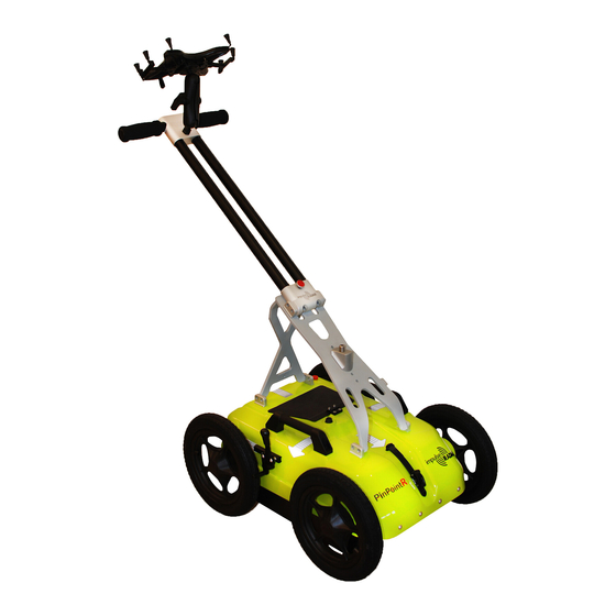
Page 6: Cart
Figure 3 Mounting the battery Cart The PinPointR Cart has a foldable handle assembly, as shown below in Figure 4. The push-cart allows the antenna to be maneuvered easily over a range of surfaces. Figure 4 PinpointR Cart (foldable) The Cart incorporates a break on the rear-right wheel, easily engaged by your foot. -
Page 7: Odometer Encoder
O-ring. If needed, this O-ring can easily be removed and replaced by first removing the wheel by unscrewing the M6 retaining screw (as shown in Figure 6 below). Note: when refitting the wheel, use blue Loctite or equivalent to help secure the M6 retaining screw. ImpulseRadar PinpointR User Manual V1.0 Page 7 (32) -
Page 8: Gps Mounts
Figure 6 Odometer encoder and wheel assembly GPS mounts An optional GPS mounting accessory is available for the push-cart, as shown below in Figure 7. Figure 7 GPS-mounts on the Cart ImpulseRadar PinpointR User Manual V1.0 Page 8 (32) -
Page 9: Overview
Sof a e Overview The PinpointR is set-up and controlled wirelessly via the IPR App once installed on a suitable Android device. Refer to Appendix A for a list of specification requirements. Note that an adapter may be needed. Android devices that meet or exceed the minimum specification requirements will generally offer better performance in terms of data recovery and on-screen functionality. -
Page 10: Using The Ipr App
App as shown. The right image shows the limited functionality when there is no antenna connection. Note: the version number of the App is shown below the Impulseradar logo of the start screen and this may be requested in the event you need support services. - Page 11 Max Depth is calculated based on the Soil Velocity. Data Mode defines how many bits are used while storing the resulting radar data. PinpointR antennas, below 600 MHz, can provide more than 16-bits, so 32b can be selected. The precise number of useful bits depends on the point distance, survey speed, and antenna frequency.
-
Page 12: Gps-Symbols And Function
The GPS symbol will change with the solutions at hand, symbols we use to show this are given in Figure 10. Note that, for the GPS-coordinates to be saved on file, the GPS-symbol need to be shown, prior to starting the data collection. ImpulseRadar PinpointR User Manual V1.0 Page 12 (32) -
Page 13: Wheels
RTK is run separated from the system, for example; in a multi-sensor setup. Wheels The Cart wheel is the default selection for the PinPointR system. Any other use of the system will require a new wheel calibration. Data viewing and adjustment The screen and system functionality differ depending on project type. - Page 14 Before starting data collection, or after stopping a line, you have access to the settings through the menu button, which is in the upper right-hand corner of the screen, as shown in Figure 11 below. Figure 15 Acess setting menu ImpulseRadar PinpointR User Manual V1.0 Page 14 (32)
-
Page 15: Restoring Missed Traces
Regardless of project type, a *.cor file (GPS coordinates) will be saved alongside the GPR data if the internal GPS can lock onto suitable satellites. ImpulseRadar PinpointR User Manual V1.0 Page 15 (32) -
Page 16: Multi-Line Project
The RL project associates and orientates GPR profiles to a straight-line reference. This can be any type of physical line that can be referred to during and after data collection. Examples include boundary, ImpulseRadar PinpointR User Manual V1.0 Page 16 (32) - Page 17 Figure 13 Multi-Line Project start screen Once the project has started, the data collection screen will appear with directional control buttons, as shown in Figure 14 below. ImpulseRadar PinpointR User Manual V1.0 Page 17 (32)
- Page 18 2. Tap on the right arrow and so on. button when the cart is on top of the reference line. 1. Tap on the forward button to start the first profile. ImpulseRadar PinpointR User Manual V1.0 Page 18 (32)
- Page 19 For this to work, the start position of each profile must be aligned with the stop position of the previous profile, as shown below in Figure 22, below. ImpulseRadar PinpointR User Manual V1.0 Page 19 (32)
- Page 20 RL-project. On import, the end of profile 1 constitutes an artificial reference line. If this is thought of prior to the survey, a DV-project may be used for post-processing/interpretation just as an RL-project. ImpulseRadar PinpointR User Manual V1.0 Page 20 (32)
-
Page 21: Gps-Projects
As the name suggests, this project type requires GPS for positioning. However, to be of any use for accurate mapping a survey-grade RTK-GPS is required. That said, it is possible to run a GPS-project using the PinPointR an enna internal GPS, but this will lack the precision required for accurate interpretation. -
Page 22: Note On Survey Speed And Settings
Note on survey speed and settings The PinpointR system can produce very large amounts of data. The bottleneck in survey speed is mostly related to the Ethernet-link. At high survey speeds and short distance intervals, the system will rarely be able to go beyond 16-... -
Page 23: Appendix A, Specifications
Appendix A, Specifications ImpulseRadar products are under continuous development and we reserve the right to change specifications at any time and without prior notice. You may verify product specifications at any time by contacting our headquarters at: support@impulseradar.se PinpointR ANTENNA... -
Page 24: Appendix B, File-Formats
(counting from 1) and XXX is a profile running number (counting from 1) ¹ Table 1 ImpulseRadar file types and descriptions ¹ file names are padded with zeros to replace ‘X’, e.g. <project name>_001_AYY.iprb Files/information stored in system... - Page 25 Table 2 Profile header file information Profile Data File This is a binary file. PinpointR can create data files with 16-bit or 32-bit data format (see the field "DATA VERSION" in header file). Samples are stored as signed 16-bit or 32-bit integers. The traces are stored sequentially.
- Page 26 <profiles> 1.201 extern gps ml outside_001_0 1.201 extern gps ml outside_001_1 1.201 extern gps ml outside_002_0 1.201 extern gps ml outside_002_1 1.201 extern gps ml outside_003_0 1.201 extern gps ml outside_003_1 </profiles> ImpulseRadar PinpointR User Manual V1.0 Page 26 (32)
- Page 27 TYPE: 3 SEPARATION: 0.25 ImpulseRadar PinpointR User Manual V1.0 Page 27 (32)
-
Page 28: Appendix C, Gps
6 miles. RTK systems are available in single and dual frequency versions; dual frequency versions are typically faster, more precise and operate over longer distances than single frequency versions, but they are correspondingly more expensive. ImpulseRadar PinpointR User Manual V1.0 Page 28 (32) -
Page 29: Appendix D, Regulatory Notices
This device contains license-exempt transmitter(s)/receiver(s) that comply with Innovation, Science and Economic Development Canada s licence-exempt RSS(s). Operation is subject to the following two conditions: (1) This device may not cause interference. ImpulseRadar PinpointR User Manual V1.0 Page 29 (32) - Page 30 For your convenience, the information required by the FCC is indicated on the next page, please print and fill in the information and put the letter in the mail. FCC will respond with confirmation of coordination. ImpulseRadar PinpointR User Manual V1.0 Page 30 (32)
- Page 31 USA Warranty service and repairs: ImpulseRadar PinpointR User Manual V1.0 Page 31 (32)
- Page 32 COMPANY NAME: __________________________________________________________________________________ __________________________________________________________________________________ __________________________________________________________________________________ PRIMARY ADDRESS: __________________________________________________________________________________ __________________________________________________________________________________ __________________________________________________________________________________ __________________________________________________________________________________ CONTACT INFORMATION [CONTACT NAME AND PHONE NUMBER]: __________________________________________________________________________________ __________________________________________________________________________________ __________________________________________________________________________________ AREA OF OPERATION [COUNTIES, STATES OR LARGER AREAS]: __________________________________________________________________________________ __________________________________________________________________________________ __________________________________________________________________________________ __________________________________________________________________________________ FCC ID (tic the box) PinpointR: 2ALZQ-CO4080...
Need help?
Do you have a question about the PinpointR and is the answer not in the manual?
Questions and answers