
Garmin GPSMAP 12 2 Series Manuals
Manuals and User Guides for Garmin GPSMAP 12 2 Series. We have 2 Garmin GPSMAP 12 2 Series manuals available for free PDF download: Owner's Manual, Installation Instructions Manual
Garmin GPSMAP 12 2 Series Owner's Manual (214 pages)
Table of Contents
-
Introduction
15 -
-
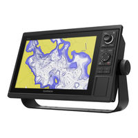
Home Screen20
-
Presets25
-
-
-
-
-
-
-
-
Chart Menu51
-
Chart Layers51
-
-
-
-
Destinations61
-
Waypoints62
-
Routes64
-
Tracks70
-
Boundaries72
-
-
Sail Racing74
-
Polar Tables76
-
-
Sonar Setup95
-
Sonar Alarms98
-
-
Radar
108-
Marpa112
-
VRM and EBL113
-
Echo Trails114
-
Radar Settings114
-
Radar Gain115
-
Radar Setup Menu117
-
-
Autopilot
119-
Autopilot Screen120
-
-
Yamaha Autopilot125
-
-
Turning on DSC130
-
DSC List130
-
-
-
Viewing Graphs142
-
-
-
-
-
-
Media Player
161-
Creating a Group164
-
Editing a Group164
-
-
Playing Music165
-
Radio165
-
DAB Playback166
-
-
Siriusxm Weather
170-
Weather Overlay175
-
Viewing Video
175-
-
Camera Settings177
-
Video Settings177
-
Camera Tracking178
-
-
-
-
System Settings185
-
-
Audio Settings185
-
-
Station Settings186
-
-
Setting Alarms191
-
System Alarms192
-
Sonar Alarms192
-
-
-
Appendix
200-
-
Software Updates202
-
Screenshots204
-
Computer204
-
Troubleshooting204
-
Specifications206
Advertisement
Garmin GPSMAP 12 2 Series Installation Instructions Manual (19 pages)
Brand: Garmin
|
Category: Fish Finder
|
Size: 0.55 MB