
Summary of Contents for VDO MAP 7w Plus GPS
- Page 1 VDO Chart Plotters _ MAP 7 V GPS _ MAP 7 cs GPS _ MAP 7 W/Wi/Plus GPS _ MAP 11 csE/Plus GPS www.vdo-marine.com...
- Page 2 S5egVDctc External Smart GPS Receiver & Video Input Copyright 2009 VDO Marine - Germany All rights reserved. Printed in Italy. No part of this publication may be reproduced or distributed in any form or by any means, or stored in a database or retrieval system, without prior written permission of the publisher.
- Page 3 User Manual...
-
Page 4: Table Of Contents
Contents About this User Manual ................11 INTRODUCTION ................11 CONVENTIONS USED ................11 EXPERT FUNCTIONS ................11 HOW THIS USER MANUAL IS ORGANIZED ............12 IF YOU NEED ASSISTANCE ................12 Important Information ................13 WARNING ................13 CAUTION ................ - Page 5 Creating Mark ................27 Selecting the User Points List page ............... 27 Editing User Point ................27 Deleting User Point ................27 Moving User Point ................27 Locating User Point on Map ................. 28 Sending/Receiving User Points ..............28 3.2 ROUTES ................
- Page 6 External Alarm ................39 3.9 USER C-CARD ................39 User C-CARD page ................39 Formatting User C-CARD ................40 Saving File on User C-CARD ................. 40 Loading File from User C-CARD ..............40 Deleting File from User C-CARD ..............40 Changing User C-CARD ................
- Page 7 4.8 C-WEATHER SERVICE ................57 Weather Service Menu ................57 Download ................58 Copy from CARD ................58 Forecast ................58 Real Time View ................59 Type of Data ................59 4.9 FISH FINDER ................59 4.10 RADAR ................59 C-LINK ................
- Page 8 7.5.11 Transducer Setup Menu ..............80 7.5.12 Alarms Menu ................80 7.5.13 Load Settings from User C-Card ............80 7.5.14 Save Settings to User C-Card ............80 7.5.15 Restore Current Preset Defaults ............80 7.6 TRANSDUCERS ................80 Maintenance ................81 8.1 SYSTEM TEST ................
- Page 9 MAP cx Plus GPS ................107 FEATURES & FUNCTIONS ................107 TECHNICAL SPECIFICATIONS ................108 INSERTING/REMOVING PROCEDURE ..............108 Inserting the C-CARD ................108 Removing the C-CARD ................108 CONTROLLER DIMENSIONS ................109 INSTALLATION AND REMOVING ................ 109 EXTERNAL WIRING ................
-
Page 10: About This User Manual
About this User Manual INTRODUCTION The chart plotter is a state-of-the-art computerized electronic chart system, de- signed as a sophisticated navigation aid. User friendly operations make the chart plotter easy to operate. All calculations and information necessary for navigation are performed and displayed on the screen quickly and accurately providing all of the facilities of a conventional GPS but with the added benefit of a powerful elec- tronic chart display. -
Page 11: How This User Manual Is Organized
List of the terms and abbreviations used in the User Manual. MAP 7w Plus GPS & MAP 7wi Plus GPS ♦ Introduction to the basic information on MAP 7w Plus GPS/MAP 7wi Plus GPS chart plotter, its features and use. Installation of the chart plotter. MAP 7cwi Plus GPS ♦... -
Page 12: Important Information
Important Information WARNING Electronic charts displayed by the chart plotter are believed to be accurate and reliable, but they are not intended to replace official charts which should remain your main reference for all the matters related to the execution of a safe naviga- tion. -
Page 13: Safety Instructions
The use of non-insulated wires and contacts is strictly forbidden. Safety Instructions concerning the maintenance Reapairs of the chart plotter system components can only be made by specialists authorized by VDO. The system fulfills the applicable safety regulations. -
Page 14: Overview
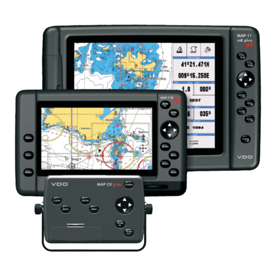
. Overview CHART PLOTTER DESCRIPTION 7w/wi 11csE Cursor Key in the display screen moves the cursor quickly and accurately in the menu page(s) scrolls the desired option in Home mode, allows to exit from Home mode in Video mode, UP/DOWN adjust the Brightness in Video mode, LEFT/RIGHT adjust the Color POWER turns On/Off the chart plotter... -
Page 15: Presentation Features
Official data source (data based on use of official data sources) ♦ Detailed World Background (worldwide background chart with details) ♦ Depths & Land Elevation (color shading of sea depth and land alti- ♦ tude for improved chart reading) Bathymetric & Spot Soundings (additional Data Base with depth ♦... -
Page 16: Max And Nt/Nt C-Card Coexistence
MAX and NT/NT C-CARD coexistence When NT data and MAX data cover different areas, the chart plotter ♦ gets data from both charts (depending on the current position). When NT data and MAX data cover the same area, the chart plotter ♦... -
Page 17: Position Fixing Accuracy: Hdop
3. When the satellite locations and their distances are known, the GPS receiver fixes its own position by triangulation: Fig. 1.3a - The GPS position calculation As illustrated in the previous figure, the position is calculated as the meeting point of three spheres which are drawn around the three satellites with diameters d1, d2 and d3. -
Page 18: Getting Started
. Getting Started This chapter provides basic information to get you started using the chart plotter; it will help you in becoming familiar with the chart display and the functions of the controls before you start using the chart plotter. SWITCHING ON/OFF Before powering On the chart plotter, check for the correct voltage (10-35 volt dc) and the correct connections with the positioning instrument. -
Page 19: Selecting The Chart Language
don’t be able to reselect your language (the above procedure is not of help to you), follow this procedure: press [MENU] two times, move the cursor to highlight the first item (starting from the top) which corresponds to the Configurations menu and press [ENTER]. Then a window appears with “Language”... -
Page 20: Controlling The Display
CONTROLLING THE DISPLAY This paragraph describes how to change the Display Mode and how to move around the chart by changing the chart scale. Changing Display Mode [MODE] more times The selected page appears on the screen. The available pages are listed in the following pictures. - Page 21 Fig. 2.7c - Example of charts with Depth graph Fix Status Date and time Ship's coordinates (Course Over Ground) Bars to indicate Used Satellite S/N Ratio Tracked, but not (Horizontal dilution of used, Satellite precision) Index for position-fixing accuracy Speed Over Ground Course Over Ground (Vertical dilution of precision) Index for...
-
Page 22: Chart With Engine Data
Fig. 2.7g - Example of External NMEA Data, if Speed, Depth and Distance data are set On (see par. 4.7 INPUT/OUTPUT - External NMEA) If you have selected a Video Input (see Par. 4.7), in the Chart page a window with the picture captured from the video signal source is shown. -
Page 23: Moving Around The Chart And Changing Chart Scale
Fig. 2.7l - Example of Twin Engine in Graph mode (left) and Digital mode (right) Moving around the Chart and Changing Chart Scale Use the cursor key to move around the chart. Also use [ZOOM IN] and [ZOOM OUT] to change the chart scale so that a smaller or larger area is shown on the chart. Finding Your Boat Position The most common use of the chart plotter is to show your ship's current location. -
Page 24: Ebl/Vrm Function
labelled "DEST". A straight line is shown on the screen connecting the destination with the ship's position. All navigation data is referred to this destination. EBL/VRM FUNCTION Selects the EBL (Electronic Bearing Line) and VRM (Variable Range Marker) func- tion: the EBL is a line with its origin on the cursor or ship's position, while the VRM is a circle with its radius is determined by the user. - Page 25 User Manual...
-
Page 26: Operations
. Operations USER POINTS: MARKS AND WAYPOINTS A User Point is an object that you can place on the charts to mark a specific point. The chart plotter features two types of User Points: Marks and Waypoints. A Waypoint is created entering a Route, while a Mark can be created at anytime at your cursor position. -
Page 27: Locating User Point On Map
Locating User Point on Map Enter the User Points List page + use the cursor to select the row with the desired User Point + "FIND" + [ENTER] The User Points List is closed and the map is centered on the selected User Point. Sending/Receiving User Points To send all stored User Points to an external device capable of listening to NMEA WPL sentence. -
Page 28: Following A Route (Activate The Navigation)
It is also possible to delete all stored Routes and Waypoints: [MENU] + [MENU] + "ROUTE" + [ENTER] + "CLEAR ALL" + [ENTER] + "YES" + [ENTER] Following a Route (Activate the Navigation) With the Route shown on the Chart page, move the cursor to the Waypoint in the Route and press [ENTER], select "GOTO"... -
Page 29: Goto Function
Production Installation ♦ Pingos ♦ No Data Available ♦ If any of these alarm conditions is detected, the function returns the list of dan- gerous objects and the relative dangerous Route leg, that is drawn with a differ- ent color. To activate this function: [MENU] + [MENU] + "ROUTE"... -
Page 30: Using Track
USING TRACK A very useful feature of the chart plotter, is the ability to store and display exactly where the boat has been. This feature, referred to as Tracking, can provide invaluable information about the effect of tide and wind influence on the boat's progress as well as giving an indication of the helmsman's performance. -
Page 31: Info
INFO Placing the cursor on cartographic objects the information related to the object nearby is shown. Setting Automatic Info Automatic Info allows you to get the information on any cartographic object just by placing the cursor on it. You can select the type of it: [MENU] + [MENU] + "ADVANCED SETTINGS"... -
Page 32: Quick Info On Lakes
Fig. 3.5a - Example of Full Info on objects with picture To see pictures: Press [MENU] when the object with a picture is highlighted To change size: Press [ENTER] when the picture is shown. Quick Info on Lakes Upon viewing the chart of a lake, you will click on to query the available information immediately displayed with many details. -
Page 33: Full Info On Lakes
the cursor will be shown. See the next paragraph. Full Info on Lakes The following is an example of Full Info on Lakes: Fig. 3.5d - Example of Full Info page To see the "Fishing" object press [MENU] (when the "Fishing" object is high- lighted). -
Page 34: Getting Tide Info
Fig.3.6a - Automatic Info window on Port To expand information about that object press [ENTER]. NOTE Port Info icon is visible only if the Ports + Services option is On Getting Tide Info Fig. 3.6b - Tide Info icon By placing the cursor over the Tide Station icon, the chart plotter pops-up the relative automatic info window (see picture below) and allows displaying a graphical page with the tides prediction of the selected object. -
Page 35: Find Function
Fig. 3.db - Tide Graph page This screen shows that day's Tide Height graph for the area where the Tidal symbol was located. Using [ZOOM IN] and [ZOOM OUT] it is possible to display future or past tides. If you wish to quickly display the tide for a specific date, press [ENTER] and enter the required date using the cursor key followed by [ENTER] once the date is set. -
Page 36: Finding Wrecks
Finding Wrecks To show the nearest Wrecks loaded in the C-CARD: [MENU] + "FIND" + [ENTER] + "WRECKS" + [ENTER] Press [ENTER] to locate the selected Wreck on the map. Finding Obstructions To show the nearest Obstructions loaded in the C-CARD: [MENU] + "FIND"... -
Page 37: Finding Lakes By Name
Fig. 3.7a - Nearest Lakes list Then choose the lake you want and press [ENTER]: the Full Info page is shown. Finding Lakes By Name To select the lakes By Name function following the procedure: [MENU] + "FIND" + [ENTER] + "LAKES BY NAME" + [ENTER] Shows the list of all lakes stored on the C-CARD in alphabetic order. -
Page 38: Audible Alarm
[MENU] + [MENU] + "ALARMS" + [ENTER] + "DEPTH ALARM" + [ENTER] Audible Alarm To enable (On) or disable (Off) the Audible Alarm. [MENU] + [MENU] + "ALARMS" + [ENTER] + "AUDIBLE ALARM" + [ENTER] Grounding Alarm To verify potential danger to navigation such shallow water (depth areas), inter- tidal areas, land, rocks, obstructions and shoreline constructions. -
Page 39: Formatting User C-Card
Fig.3.9 - User C-CARD Menu Formatting User C-CARD In order to be able to use a new User C-CARD you must format it first. This operation prepares the User C-CARD to receive and store information: [MENU] + [MENU] + "USER C-CARD" + [ENTER] + "FORMAT" + [ENTER] NOTE When a User C-CARD is formatted, all data saved on it will be deleted. -
Page 40: Changing User C-Card
MAP 11csE Plus GPS/MAP cX Plus GPS: Changing User C-CARD Allows to select the slot in which the User C-CARD is inserted. [MENU] + [MENU] + "USER C-CARD" + [ENTER] + "CHANGE" + [ENTER] User Manual... - Page 41 User Manual...
-
Page 42: User Setting Up
. User Setting Up MAP MENU To set up the map layout (available only from the chart page): [MENU] Zoom Type [MENU] + "ZOOM TYPE" + [ENTER] Allows larger expansion or compression of the chart scale while zooming in or out. Zoom Type has two options;... -
Page 43: Dynamic Nav Aids
Fig. 4.1a - Perspective View Dynamic Nav Aids [MENU] + "DYNAMIC NAV-AIDS" + [ENTER] This function allows settings blinking lights on Nav-Aids. The blink period and color of each Nav-aid is read from the Nav-Aid attributes available on the data cartridge. -
Page 44: Satellite Imagery
condition. The Warning Icon remains displayed until the alarm condition persists. Placing the cursor over this Icon, a quick help message is shown next to the Icon, allowing to show the Safety Status Bar. In this case - when the Safety Status Bar is opened via Warning alarm Icon - it is allowed to obtain information about each “active”... -
Page 45: Land Settings
The possible choices are listed in the table below: Normal : It is recommended when the chart plotter is not exposed to the direct sunlight. When this mode is set the maps are displayed in order to use colors as similar as possible to the ones used in the original paper charts. -
Page 46: Depth Settings
Names : Sets On/Off the displaying of the Names (local area names). Name Tags : Sets On/Off the displaying of a tag for particular chart objects that either includes the Name of the chart object or the Depth of an Underwater chart object. Available for Buoys, Towers, Beacons and Port Marinas. -
Page 47: Underwater Objects Settings
Value Added Data : Sets On/Off the displaying of the Value Added Data. The Value Added Data (VAD) is a collection of additional cartographic objects which are not present on the original paper chart (from which the electronic chart derives). These objects have been obtained from other sources (that C-MAP believes to be reliable) and then merged to the electronic charts in order to provide more information useful for the navigation. -
Page 48: Advanced Settings
Screen Amplifier : Allows, when it is On and Home mode is set, to place map on the screen related to the fix position and direction, so the map shown is that before the ship. Depth Window : Turns On/Off the displaying of the Depth Window on the screen. When the Depth Window is set On and depth value is received from an echosounder, the depth value and unit are shown on the screen. -
Page 49: Compass Menu
Datum currently selected in the menu in order to match the position from the GPS with the position on the charts. You must know what datum reference is used by the GPS and set it in the Fix Datum option. Map Datum : Allows selecting any Geodetic Datum reference from the over 100 available on the chart plotter. -
Page 50: Ais
perature; Fuel Level; Turbocharger 1 Turbine Inlet Temperature; Turbocharger 2 Turbine Inlet Temperature; Electrical Potential (Voltage); Battery Potential (Voltage), Switched; Battery 2 Potential (Voltage). Engine Alarms : Alarms can be defined for the most important engine data. A warning is given if the set alarm value for speed, any of the measured temperatures or fuel reserve is exceeded. -
Page 51: Ais Menu
Name ♦ Name of ship, 20 characters. MMSI ♦ Maritime Mobile Service Identity. MMSI number ♦ A unique 9 digit number that is assigned to a DSC radio station. It prima- rily registers the boat information in the U.S. Coast Guard’s national dis- tress database for use in emergency situations. -
Page 52: To Set The Chart Plotter For Receiving Ais
= 1/4/5 for MAP 7cwi Plus GPS n = 1/2/4/5 for MAP 7wi Plus GPS n = 1/2/3/4/5 for MAP 7w Plus GPS/MAP CX Plus m = NMEA-0183 4800-N81-N; AIS 38400 according to the transmission speed of your AIS receiver. -
Page 53: Input/Output
= 1/2/3 for MAP 11csE Plus GPS n = 1/4/5 for MAP 7cwi Plus GPS n = 1/2/4/5 for MAP 7wi Plus GPS n = 1/2/3/4/5 for MAP 7w Plus GPS/MAP CX Plus External NMEA Connection Connect the External NMEA to the serial Port n: [MENU] + [MENU] + "INPUT/OUTPUT"... -
Page 54: Nmea Output
= 1/4/5 for MAP 7cwi Plus GPS n = 1/2/4/5 for MAP 7wi Plus GPS n = 1/2/3/4/5 for MAP 7w Plus GPS/MAP CX Plus Send/Receive Routes & Marks Sets the desired port used for transferring User Points and Routes functions: [MENU] + [MENU] + "INPUT/OUTPUT"... -
Page 55: Aux In I/O Cable Wiring Page
[MENU] + [MENU] + "INPUT/OUTPUT" + [ENTER] + "AUX IN I/O CABLE WIRING" + [ENTER] MAP 7w Plus GPS/MAP 7wi Plus GPS/MAP 7cwi Plus GPS: Quick Disconnect Cable Wiring page Shows a window containing the cable wiring of the quick disconnect bracket. -
Page 56: C-Weather Service
[MENU] + [MENU] + "INPUT/OUTPUT" + [ENTER] + "VIDEO INPUT" + [ENTER] Select Video Input : Available options are the following: Full Video 1: Shows the image from the video camera 1 at full screen. Full Video 1 + Video 2 Small: Shows the image from the video camera 1 at full screen, with the image from the video camera 2 on a window which can be moved up/ down and/or right/left using the cursor key. -
Page 57: Download
Download ♦ Copy From CARD ♦ Forecast ♦ Real Time View ♦ Type of Data ♦ Download [MENU] + [MENU] + "WEATHER SERVICE" + [ENTER] + "DOWNLOAD" + [ENTER] Allows to connect the software to the Jeppesen Marine weather server and to download Jeppesen Marine weather data directly via C-COM. -
Page 58: Real Time View
Real Time View [MENU] + [MENU] + "C-WEATHER SERVICE" + [ENTER] + "REAL TIME VIEW" + [ENTER] The following selections are available: Real Time View On : the data is shown (the area of the download) at the current date and time (received from the GPS). - Page 59 User Manual...
-
Page 60: C-Link
. C-LINK C-LINK C-Link system is a feature which allows to sharing the same cartographic data between two Chart Plotter units linked via serial I/O port. In order to activate C-Link function, a “MAX data C-CARD” (called REGULAR C- CARD) must be inserted into one of the two chart plotters and a special MAX data C-CARD (called MIRROR C-CARD) must be inserted on the other chart plotter. -
Page 61: Operations
and activate the navigation to it. Any variation to the current C-Link Navigation Data will be transferred from the Master to the Slave. The Slave will be provided with a few dedicated pages to show the C-Link Navi- gation Data received from the Master. Operations Introductive elements It is important remark, once more, that this function does not transfer the whole... -
Page 62: Slave Chart Plotter
Under such condition if the navigation is activated on one of the two chart plot- ters, a warning message will be shown to notify that the C-Link navigation data will be ignored by the other Chart Plotter. Slave Chart Plotter Operating mode To select the Slave mode follow the procedure: [MENU] + [MENU] + "Input/Output"... -
Page 63: Graphical Representation On Map Display
Graphical representation on Map Display Fig. 5.2 - Graphical Displaying Route Data Report When the Navigation to the External Route is received, it will be possible to dis- play the information related to the External Route by entering the Route Data Report. -
Page 64: Quick Info
+Distance From Dest to last Wpt received from $PCMPN,1) TTG To Destination : Estimated Time to travel the “Distance to ♦ Last Wpt” (calculated using Cruising Speed) TTG To Next Wpt : Estimated Time to travel the “Distance to ♦ Next Waypoint”... - Page 65 User Manual...
-
Page 66: Mobilarm System
. MOBILARM System The MOBILARM is an automated crew monitoring system dedicated to monitoring onboard crew by maintaining a constant link between the crew member and the boat. The instant a man over-board event happens, an automatic alarm is sounded, and the vessels position is logged. -
Page 67: Mobilarm Ptx
is Ok; Signal Lost : the device has been detected but now the ♦ signal is no longer received; No valid GPS position : the communication with MOBILARM device ♦ is Ok but the GPS position fix is not received. MOBILARM PTX PTX is the personal transponder device that is worn by the crew. -
Page 68: Placing Cursor On The Ptx Icon
If the received PTX is NOT the active one, the user must confirmed to navigate to it. Otherwise if the received PTX is the active one (the PTX on which we are navigating to), navigation data are updated in memory, the new PTX coordinates becames the Destination position and the current Fix position becames the starting position. -
Page 69: 6.4.4 Show Ptx
PTX status PTX indentifier MOBILARM-Alarm Status List RECOVERED 213°22.120W 20°01.022N 03:45:14 PM Recovered 10:31:24 PM 305°04.015W 79°56.320N Recovered Time of PTX creation PTX position Fig. 6.4.3 - Example of MOBILARM PTX List page This page allows you to: GOTO : Activates navigation to the selected PTX. Once the navigation has been activated, close all menus/data pages (if open) and center the chart selected PTX. -
Page 70: Setting The Internal Fish Finder On
. Fish Finder MAP 7 ONLY FOR The Fish Finder consists of a high power transmitter, sensitive receiver and a transducer. The Fish Finder sends an electrical pulse to the transducer which contains an element that converts the pulse into acoustic (sound) wave which is sent through the water. -
Page 71: Echogram Window
Fig. 7.2 - The Fish Finder page The following is a short description of terms listed in the previous Fig. 7.2: Warning Message Flashing label "Simulation" when the echo sounder is in Simulation mode. Echogram window Graphic presentation of sonar soundings recorded as a continuous profile scrolling across the screen from right to left. -
Page 72: 7.2.1 Understanding The Echogram Display
Variable Depth Marker (VDM) Horizontal line on to the Echogram window with a depth label. The up/down cursor keys can move it up and down. The label displays the depth of the cursor position. It can be moved to any location pinpointing the depth of a target. -
Page 73: Displaying The Fish Finder Page
White Line The White Line shows the difference between hard, soft bottoms and even distinguishes between fishes and structures located near the bottom. In this way it is easier to tell the difference between a hard and soft bottom and even to distinguish fishes and structures located nearby the bottom. -
Page 74: 7.3.3 Dual Frequency Page
Functions menu. The Cursor key Moving the Cursor key up/down adjusts the Variable Depth Marker (VDM) up or down on the screen. The ENTER key Pressing [ENTER] activates the Sensitivity menu (see Par. 7.6.9) that allows tuning the Gain, the Surface Noise Filter and the STC. Fig. -
Page 75: 7.3.5 Chart/Fish Page
[MODE] more times until the Fish Finder Zoom page is displayed Fig. 7.3.4 - Fish Finder Zoom Page The Depth Cursor is shown only on the unzoomed Fish Finder Echogram. The ZOOM IN and ZOOM OUT keys When in this page pressing [ZOOM IN] changes to Zoom 4X, pressing [ZOOM OUT] changes to Zoom 2X. -
Page 76: Zoom Modes
Fig. 7.3.6 - Radar/FF page Otherwise to display the Radar and Fish Finder Combo pages, follow this procedure: [MODE] more times until the Fish Finder Radar/FF/Chart/Nav Data page is displayed Fig. 7.3.6a - Radar/FF/Chart/Nav Data page NOTE The Radar/FF/Chart/Nav Data page is available only if a Target has been set. When in Split/Combo pages, the active view is highlighted by a focus (Yellow frame). -
Page 77: Fish Finder Setup Menu
FISH FINDER SETUP MENU The Fish Finder Setup menu provides access to additional functions, setup and layout/data field options. From the Fish Finder page, access this menu by pressing: [MENU] Fig. 7.5 - Fish Finder Setup menu 7.5.1 Preset Mode Preset modes are pre-defined settings of the Fish Finder operating parameters. -
Page 78: 7.5.6 Bottom Range
Range and Bottom Lock Mode. [MENU] + "SHIFT" + [ENTER] NOTE The bottom Range, Depth, Shift will apply to the currently selected frequency. 7.5.6 Bottom Range This option is available when Range Mode is Bottom Lock. [MENU] + "BOTTOM RANGE" + [ENTER] 7.5.7 Frequency Allows you to choose the frequency between Auto, 50 kHz or 200 kHz when single frequency page is selected. -
Page 79: Transducer Setup Menu
The transducer is a device that transmits and receives sound waves into the water. The active component inside the transducer is commonly referred to as an element but actually is a piezoelectric ceramic material. Please refer to your dealer and/or installer to choose your transducer. VDO sug- gest transducers. -
Page 80: Maintenance
. Maintenance This chapter gives information on routine maintenance and problem solving asso- ciated with the chart plotter. SYSTEM TEST If you have connected your position-finding device according to the instructions, and chosen the proper menu selection for your device, and are still having prob- lems with your chart plotter, the extended auto-test should help determine the problem. -
Page 81: Serial Ports
Serial Ports Change parameters: Changes the parameters of the serial interface. This menu allows to select the Port (Signal Source), the Baud Rate, the Data Bits (Word Length) between 7 or 8, the Parity between even, odd or none, the Stop Bits between 1 or 2. -
Page 82: Terms
. Terms ALT = Altitude ♦ Altitude of GPS Antenna on the medium sea level. Alter = Alternate Solution (TD Coordinates System) ♦ Parameter selected by the user that is applied in the conversion of TD values to geographical coordinates Lat/Lon. It defines which of the two possible solu- tions can be used. -
Page 83: Cultural Features
♦ Geographical distance between two points on the map. Easy Link ♦ VDO-specific interface to actuate slave indicators. EBL = Electronic Bearing Line ♦ EBL is a dotted line: the origin of the line is the ship's or cursor position. -
Page 84: Fix Status
file must have a unique name, ideally one that describes its contents. Filenames are kept in a directory on each User C-CARD. ♦ Current position of the vessel provided by the GPS (connected to the chart plotter or built-in) or other positioning systems. Fix Status ♦... -
Page 85: Magnetic Variation
Magnetic Deviation ♦ Value, expressed in degrees East or West that indicates the direction in which the north indicator on the compass card is offset from the magnetic north (the difference expressed in degrees East or West between the compass north and the magnetic north). -
Page 86: Spot Soundings
Navigational information normally found in good pilot books and a presen- tation software which displays special Port Facility Symbols. Ports & Services ♦ Areas along shore with facilities for mooring, downloading and uploading of ships, generally sheltered from waves and winds. Port installations are piers, wharves, pontoons, dry docks, cranes... - Page 87 Turbocharger Turbine Inlet Temperature ♦ Exhaust gas temperature before the turbocharger. TWD = True Wind Direction ♦ Direction of the Wind relative to a fixed point on the earth. TWS = True Wind Speed ♦ Velocity of the Wind relative to a fixed point on the earth. Underwater Objects ♦...
-
Page 88: Map 7W & Map 7Wi Plus Gps
MAP 7w & MAP 7wi Plus GPS FEATURES & FUNCTIONS Direct sunlight viewable color LCD 16/9 display ♦ Worldwide Built-in Cartography showing C-MAP B detail up to ♦ EPPESEN 2.0 NM "C-MAP B " MAX electronic charts, object-oriented chart sys- ♦... -
Page 89: Technical Specifications
Chart plotter's protective cover ♦ Fuse 2 Amp. + fuseholder ♦ MAP 7w Plus GPS Flush mounting kit ♦ MAP 7w Plus GPS Smart DGPS WAAS Receiver with cable 15 mt/45 feet ♦ User Manual ♦ INSERTING/REMOVING PROCEDURE Inserting the C-CARD Open the door, hold the C-CARD by the long side so that you can see the label and gently push the C-CARD into the door slot (1). -
Page 90: Chart Plotter Dimensions
GRAY parts are present ONLY on chart plotter WITH INTERNAL INSTALLATION AND REMOVING GRAY parts are present ONLY on chart plotter WITH INTERNAL MAP 7w Plus GPS flush installation and MAP 7w Plus GPS/MAP 7wi Plus GPS bracket installation User Manual... -
Page 91: External Wiring
EXTERNAL WIRING External Wiring for MAP 7w Plus GPS External Wiring for MAP 7wi Plus GPS User Manual... -
Page 92: Typical Connections
TYPICAL CONNECTIONS GPS Connection on Port 3 for MAP 7w Plus GPS QUICK DISCONNECT BRACKET CABLE WIRE COLOR DESCRIPTION FUNCTION BLACK POWER GND POWER SUPPLY GND POWER +10-35Vdc POWER SUPPLY+ WHITE INPUT1+ NMEA0183/C-COM GREEN SIGNAL RETURN- SIGNAL RETURN YELLOW OUTPUT1+... - Page 93 C-COM GSM Plus CABLE QUICK DISCONNECT BRACKET CABLE WIRE COLOR DESCRIPTION FUNCTION WIRE COLOR FUNCTION BLACK POWER GND POWER SUPPLY GND BLACK POWER +10-35Vdc POWER SUPPLY+ POWER SUPPLY+ WHITE INPUT 1+ C-COM WHITE C-COM TX+ GREEN SIGNAL RETURN- SIGNAL RETURN GREEN C-COM TX- YELLOW...
-
Page 94: Map 7Cwi Plus Gps
MAP 7cwi Plus GPS FEATURES & FUNCTIONS Direct sunlight viewable color LCD 16/9 display ♦ Worldwide Built-in Cartography showing C-MAP B detail up to ♦ EPPESEN 2.0 NM "C-MAP B " MAX electronic charts, object-oriented chart sys- ♦ EPPESEN tem with enhanced functionality including: Guardian alarm, Safety toolbar, Safety route check Perspective view Satellite image coverage... -
Page 95: Technical Specifications
TECHNICAL SPECIFICATIONS Operating Voltage : 10 - 35 Volt dc ♦ Power consumption : 12W average; 27W max peak ♦ Interface : NMEA-0183 ♦ Autopilot Interface : NMEA-0180, NMEA-0180/CDX, NMEA-0183 ♦ Display : Color Sunlight Viewable LCD ♦ (active area 7") Display Resolution : 800 x 480 pixels ♦... -
Page 96: Removing The C-Card
Removing the C-CARD To remove the C-CARD inserted in the chart plotter open the door (1). The C- CARD will eject out of the chart plotter slot remaining fixed into the door (2). Then remove the C-CARD from the slot (3). CHART PLOTTER DIMENSIONS INSTALLATION AND REMOVING User Manual... -
Page 97: External Wiring
EXTERNAL WIRING TYPICAL CONNECTIONS Autopilot Connection on Port 1 External NMEA Connection on Port 1 User Manual... - Page 98 C-COM GSM Plus CABLE QUICK DISCONNECT BRACKET CABLE WIRE COLOR DESCRIPTION FUNCTION WIRE COLOR FUNCTION BLACK POWER GND POWER SUPPLY GND BLACK POWER +10-35Vdc POWER SUPPLY+ POWER SUPPLY+ WHITE INPUT 1+ C-COM WHITE C-COM TX+ GREEN SIGNAL RETURN- SIGNAL RETURN GREEN C-COM TX- OUTPUT 1+...
- Page 99 User Manual...
-
Page 100: Map 11Cse Plus Gps
MAP 11csE Plus GPS FEATURES & FUNCTIONS Direct sunlight viewable color 11" LCD display ♦ Worldwide Built-in Cartography showing C-MAP B detail up to ♦ EPPESEN 2.0 NM "C-MAP B " MAX electronic charts, object-oriented chart sys- ♦ EPPESEN tem with enhanced functionality including: Guardian alarm, Safety toolbar, Safety route check Perspective view Satellite image coverage... -
Page 101: Technical Specifications
CAN bus inputs and receives engine data. The display unit also has two bus outputs to transfer data to VDO Easy Link Indicators. A maximum of 20 Easy Link indicators can be connected per output. -
Page 102: Removing The C-Card
Removing the C-CARD Open the door and remove the C-CARD out of one of the two slots (as shown in the right side of the previous picture). CHART PLOTTER DIMENSIONS 125mm [4.9”] 329mm [13”] 211mm [8.3”] INSTALLATION AND REMOVING User Manual... -
Page 103: External Wiring
EXTERNAL WIRING POWER & I/O CONNECTOR/CABLE AUX-IN I/O CABLE/CONNECTION ENGINE WIRE COLOR FUNCTION WIRE COLOR FUNCTION BLACK GND/COMMON CAN hi Port Engine WHITE POWER INPUT +10-35Vdc Easy Link voltage supply WHITE INPUT1+ EL DATA Port Engine GREEN GREEN INPUT1- GRAY EL DATA Starboard Engine GRAY OUTPUT2+... -
Page 104: Autopilot Connection
SMART GPS GPS SENSOR CABLE GPS SENSOR CABLE SENSOR WIRE COLOR FUNCTION POWER OUTPUT+ (10-35 Vdc) GREEN GPS RX+ BROWN GPS TX+ ANTENNA BLACK/YELLOW/SHIELD GND COMMON GPS on Port 3 Autopilot Connection POWER SUPPLY POWER & I/O POWER & I/O CABLE POWER &... -
Page 105: C-Com Connection
POWER SUPPLY POWER & I/O POWER & I/O CABLE POWER & I/O CABLE EXTERNAL WIRE COLOR FUNCTION NMEA COMMON BLACK PWR-/GND/COMMON POWER INPUT+ (10-35 Vdc) DEVICE GRAY OUTPUT 2+ BROWN INPUT 2+ External NMEA on Port 2 C-COM Connection POWER & I/O CONNECTOR POWER &... -
Page 106: Map Cx Plus Gps
MAP cx Plus GPS FEATURES & FUNCTIONS Worldwide Built-in Cartography showing C-MAP B detail up to ♦ EPPESEN 2.0 NM "C-MAP B " MAX electronic charts, object-oriented chart sys- ♦ EPPESEN tem with enhanced functionality including: Guardian alarm, Safety toolbar, Safety route check Perspective view Satellite image coverage Turbo and Smooth Zoom... -
Page 107: Technical Specifications
TECHNICAL SPECIFICATIONS Power consumption : 0.25 A max, @ 12 V ♦ Interface : NMEA0183 ♦ Autopilot Interface : NMEA-0180, NMEA-0180/CDX, NMEA- ♦ 0183 Video Output : VGA compatible ♦ Display Resolution : 640x480 or 800x600 or 1024x768 ♦ pixels user selectable Cartography : C-MAP B C-CARD... -
Page 108: Controller Dimensions
CONTROLLER DIMENSIONS INSTALLATION AND REMOVING WARNING In order to protect the chart plotter video board, please make sure that the power cables of the monitor and of the chart plotter are physically separated, with protection against electrical discharge. Flush installation User Manual... -
Page 109: External Wiring
Bracket installation EXTERNAL WIRING AUX-IN I/O CONNECTOR/CABLE WIRE COLOR FUNCTION BLACK GND/COMMON VIDEO OUTPUT POWER OUTPUT+ (10-35 Vdc) CONNECTOR WHITE INPUT 4+ PIN FUNCTION GREEN GRAY OUTPUT 5+ YELLOW OUTPUT 4+ BROWN INPUT 5+ BLUE EXTERNAL ALARM OUTPUT+ HSYNC VSYNC N.C. -
Page 110: Typical Connections
TYPICAL CONNECTIONS GPS Connection SMART GPS POWER SUPPLY SENSOR POWER & I/O POWER & I/O CABLE POWER & I/O CABLE GPS SENSOR CABLE GPS SENSOR CABLE WIRE COLOR FUNCTION WIRE COLOR FUNCTION BLACK PWR-/GND/COMMON POWER INPUT+ (10-35 Vdc) POWER OUTPUT+ (10-35 Vdc) WHITE GREEN INPUT 1+... -
Page 111: External Nmea Connection
POWER SUPPLY POWER & I/O POWER & I/O CABLE POWER & I/O CABLE WIRE COLOR FUNCTION COMMON BLACK PWR-/GND/COMMON AUTOPILOT POWER INPUT+ (10-35 Vdc) GRAY OUTPUT 2+ BROWN INPUT 2+ Autopilot on Port 2 External NMEA Connection POWER SUPPLY POWER & I/O POWER &... -
Page 112: Specification Of Can Interfaces Map
MAP 11 Data input: CAN 2.0B; SAE J1939 The VDO Chart Plotter MAP 11csE/MAP 11csE Plus receives data from a CAN 2.0B Interface. Data are transferred at this interface in SAE J1939 format. You will find the Parameter Group Numbers (PGN) of the data received by the Chart Plotter in the following table. - Page 113 User Manual...
-
Page 114: Installing The Smart Gps External Map
Installing the Smart GPS External MAP 7 GPS/MAP 11 GPS/MAP Installing Choose a location for the antenna that has a clear view of the sky. Ensure there are no major obstructions or fixtures in the immediate proximity to the antenna. The antenna relies on direct “line of sight”... -
Page 115: Dimensions
3. Remove the template and let the cable go through the central hole 4. Apply a small coat of RTV to the underside of the antenna 5. Place the antenna and then screw it with the three M3 screws Installing GPS Antenna (III) Dimensions GPS Antenna Dimensions User Manual... -
Page 116: Analytical Index
Analytical Index C-Link serial connection ......61 3D Navigation Data ........22 C-Weather Service ........57 Cable Wiring ..........56 Calibrate Aux Temp ........80 A-Scope ........... 73 Calibrate Sound Speed ....... 80 About page ..........67 Calibrate Water Speed ....... 80 Activate Navigation ........ - Page 117 Data Features ........... 15 Enhanced Turbo-Zoom ....... 16 Data Safety Indicator ........ 44 ENTER ............. 15 Date (Simulation) ........20 Estimated Time of Arrival ......84 Date Format ..........49 ETA ............84 Datum ............. 84 Exhaust Gas Temperature ......84 Deactivating Track Recording ......
- Page 118 GPS Antenna .......... 115 Magnetic Variation ........86 GPS Antenna Dimensions ......116 Maintenance ..........81 GPS Connection ....92, 93, 104, 111 Man OverBoard ......... 25 GPS page ..........22 Map Datum ..........50 Grounding Alarm ........39 Map menu ..........43 Grounding Alarm Range ......
- Page 119 POWER ............ 15 Sensitivity sub-menu ......... 75 Power I/O Cable Wiring ......56 serial port ..........13 Presentation Features ........ 16 Serial Ports ..........82 Preset Mode ..........78 Set Defaults Settings ......... 80 Primary Chart Plotter ......... 61 Setup menu ..........49 Production Installation .......
- Page 120 True Wind Speed ........88 VRM ..........25, 88 True-Type Font ......... 16 VTG ............55 TTG ............87 Turbo-Zoom ..........16 Turbocharger Turbine Inlet Temp ....88 WAAS ............88 Turning ........... 87 WARNING ..........13 TWD ............88 Warning Message (FF) .......