Table of Contents
Advertisement
Quick Links
Advertisement
Table of Contents
Troubleshooting

Related Manuals for Garmin DEZL OTR810


Summary of Contents for Garmin DEZL OTR810
- Page 1 DĒZL OTR810 / OTR1010 / ™ LGV810 / LGV1010 Owner’s manual...
- Page 2 © 2022 Garmin Ltd. or its subsidiaries All rights reserved. Under the copyright laws, this manual may not be copied, in whole or in part, without the written consent of Garmin. Garmin reserves the right to change or improve its products and to make changes in the content of this manual without obligation to notify any person or organisation of such changes or improvements. Go to www.garmin.com...
-
Page 3: Table Of Contents
Table of contents Finding Lorry Parking in Europe..19 Finding Parking Near Your Current Location..........19 Getting started......... 1 Search tools...........19 Device Overview........1 Finding a junction......19 Mounting and Powering the Device in Finding a location using Your Vehicle..........3 coordinates........ - Page 4 Changing the route calculation Hands-free calling......... 36 mode..........28 Placing a call........36 Stopping the route.........28 Receiving a call........36 Using Suggested Routes...... 28 Using in-call options......37 Avoiding Delays, Tolls and Areas..28 Saving a Phone Number as a Avoiding traffic delays on your Preset..........
- Page 5 Starting a Drive........44 Planning a Route....... 55 Garmin eLog App Overview....45 Editing and Reordering Locations in a Garmin eLog Map Tool Overview..46 Route..........56 Driving in a Team....... 47 Changing Routing Options for a Changing Duty Status....... 47 Route..........
- Page 6 Date and time settings......63 Connecting a Control Input....73 Device settings........64 Connecting the Device to Vehicle Power..........73 Device information......64 Pairing with a Garmin Navigation Viewing E-label Regulatory and Device..........74 Compliance Information....... 64 Garmin PowerSwitch Specifications........64 Specifications........
-
Page 7: Getting Started
Getting started WARNING See the Important safety and product information guide in the product box for product warnings and other important information. • Update the maps and software on your device (Updating Maps and Software Using a Wi‑Fi Network, page 65). - Page 8 Microphone for hands-free calling and voice command Volume control Power key USB power and data port Map and data memory card slot Magnetic mount interface with 14-pin connector Speaker Getting started...
-
Page 9: Mounting And Powering The Device In Your Vehicle
Mounting and Powering the Device in Your Vehicle WARNING This product contains a lithium-ion battery. To prevent the possibility of personal injury or product damage caused by battery exposure to extreme heat, store the device out of direct sunlight. Both the device and its mount contain magnets. Under certain circumstances, magnets may cause interference with some internal medical devices and electronic devices, including pacemakers, insulin pumps or hard drives in laptop computers. - Page 10 3 If necessary, loosen the thumbscrew on the suction cup arm and the nut on the ball mount , and adjust the mount for better viewing and operation. 4 Tighten the thumbscrew on the suction cup arm and the nut on the ball mount. Getting started...
- Page 11 5 Place the device onto the magnetic mount. 6 Plug the other end of the vehicle power cable into a power outlet in your vehicle. Getting started...
-
Page 12: Installing The Screw-Down Mount On The Dashboard
® is not responsible for any damages or consequences arising from the installation. NOTICE To avoid possible damage to your vehicle, Garmin recommends professional installation of the screw-down ball mount. 1 Place the mount on the selected location. 2 Using the mount as a template, mark the three screw locations. - Page 13 5 Insert the ball mount arm into the mount. 6 Insert the thumbscrew into the mount and tighten it to secure the ball mount arm. Getting started...
-
Page 14: Installing The Ball Mount Adapter
Installing the Ball Mount Adapter Your device includes a one-inch ball mount that is compatible with third-party mounting solutions. 1 Remove the four screws securing the mount socket to the magnetic mount. 2 Remove the mount socket. 3 Secure the one-inch ball mount to the magnetic mount using the screws removed in step 1. -
Page 15: Turning The Device On Or Off
Turning the device on or off • To turn the device on, press the power key or connect the device to power. • To put the device in power saving mode, press the power key while the device is on. While in power saving mode, the screen is off and the device uses very little power, but it can wake instantly for use. -
Page 16: Home Screen
The home screen contains shortcuts for frequently used apps. The app drawer contains all the apps installed on your device, organised into two tabs. The dēzl tab contains Garmin apps useful for navigation and hours of service recording. The Tools tab contains apps useful for communication and other tasks. -
Page 17: Adding Shortcuts To The Home Screen
Adding Shortcuts to the Home Screen 1 Select 2 Select an app tab to view additional applications. 3 Hold an application, and drag it to a location on the home screen. Viewing Notifications WARNING Do not read or interact with notifications while driving, because doing so can cause distraction that could lead to an accident resulting in serious personal injury or death. -
Page 18: Vehicle Profiles
Vehicle Profiles WARNING Entering your vehicle profile characteristics does not guarantee that your vehicle's characteristics will be accounted for in all route suggestions or that you will receive the warning icons in all cases. Limitations may exist in the map data such that your device cannot account for these restrictions or road conditions in all cases. Always defer to all posted road signs and road conditions when making driving decisions. -
Page 19: Changing Your Trailer Information
Changing your trailer information Before you can change your trailer information, you must enter a vehicle profile for a tractor (Adding a vehicle profile, page 12). When you change the trailer on your lorry, you can change the trailer information in your vehicle profile without changing the lorry information. -
Page 20: Driver Awareness Features And Alerts
The driver alerts and speed limit features are for information only. They do not replace your responsibility to abide by all posted speed limit signs and to use safe driving judgement at all times. Garmin is not responsible for any traffic fines or citations that you receive for failing to follow all applicable traffic laws and signs. -
Page 21: Red Light And Speed Cameras
Red light and speed cameras NOTICE Garmin is not responsible for the accuracy of or the consequences of using a red light or speed camera database. NOTE: this feature is not available for all regions or product models. Information about red light and speed camera locations is available in some areas for some product models. -
Page 22: Finding Lorry Use Points Of Interest
Finding lorry use points of interest NOTICE You are responsible for understanding and complying with any applicable rules, laws or regulations associated with points of interest. The detailed maps loaded on your device contain lorry use points of interest, such as motorway services, roadside services and weighbridges. -
Page 23: Searching Within A Category
Searching within a category After you have performed a search for a point of interest, certain categories may display a Quick Search list that displays the last four destinations you selected. 1 Select Where To? > Categories. 2 Select a category. 3 Select an option: •... -
Page 24: Changing The Search Area
Installing POI Loader You can create or download custom POI lists on your computer and install them on your device using POI Loader software. 1 Go to www.garmin.com/poiloader. 2 Follow the on-screen instructions. Finding custom POIs Before you can find custom POIs, you must load custom POIs on your device using the POI Loader software (Installing POI Loader, page 18). -
Page 25: Parking
4 Select View on Map. Tripadvisor NOTICE Garmin is not responsible for the accuracy or timeliness of the Tripadvisor information. You are responsible for understanding and complying with any applicable rules, laws or regulations associated with points of interest. Your device includes Tripadvisor traveller ratings. Tripadvisor ratings appear automatically in the search results list for restaurants, hotels and attractions. -
Page 26: Finding Tripadvisor Points Of Interest
Finding Tripadvisor points of interest 1 Select Where To? > Tripadvisor. 2 Select a category. 3 If necessary, select a subcategory. A list of nearby Tripadvisor points of interest for the category appears. 4 Select Sort Results to filter the displayed points of interest by distance or popularity (optional). 5 Select , and enter a search term (optional). -
Page 27: Removing A Shortcut
Removing a shortcut 1 Select Where To? > > Remove Shortcut(s). 2 Select a shortcut to remove. 3 Select the shortcut again to confirm. 4 Select Done. Saving Locations Saving a location 1 Search for a location (Finding a location by category, page 16). -
Page 28: Deleting A Favourite Location
Deleting a favourite location NOTE: deleted locations cannot be recovered. 1 Select Where To? > Favourites. 2 Select > Delete. 3 Select the box next to the favourite locations to delete and select Delete > Yes. Navigating to your destination Routes A route is a path from your current location to one or more destinations. -
Page 29: Your Route On The Map
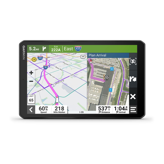
Editing your home location 1 Select Where To? > > Set Home Location. 2 Enter your home location. Your route on the map As you travel, the device guides you to your destination using voice prompts and information on the map. Instructions for your next turn or exit, or other actions appear across the top of the map. - Page 30 Distance to the next action. Next action in the route. Indicates the next turn, exit, or other action and the lane in which you should travel, if available. Name of the street or exit associated with the next action. Route highlighted on the map. Next action in the route.
-
Page 31: Active Lane Guidance
Active lane guidance As you approach some turns, exits, or interchanges in your route, a detailed simulation of the road appears beside the map, if available. A coloured line indicates the proper lane for the turn. Viewing Popular Lorry Paths on the Map You can enable the device to highlight popular lorry paths on the map. -
Page 32: Planning Your Arrival
Planning Your Arrival Before you start a route, you can plan to arrive at a popular lorry destination, such as a loading dock or lorry parking, at the end of your route. You can also add your own destinations to the map. 1 Select Where To?, and search for a location (Finding and saving locations, page 15). -
Page 33: Parking Near Your Destination
Parking Near Your Destination Your device can help you find a parking spot near your destination. When you approach some destinations, the device automatically suggests parking areas. NOTE: this feature should be used only when you are using the car vehicle profile. While using a lorry vehicle profile, you can search for lorry parking near your destination (Finding lorry parking, page 19). -
Page 34: Taking A Detour
Taking a detour You can take a detour for a specified distance along your route or detour around specific roads. This is useful if you encounter construction zones, closed roads or poor road conditions. 1 From the map, select > Edit Route. 2 Select an option: •... -
Page 35: Custom Avoidances
Custom Avoidances Custom avoidances allow you to select specific areas or sections of road to avoid. When the device calculates a route, it avoids these areas and roads unless no other reasonable route is available. Avoiding a road 1 Select Settings > Navigation > Custom Avoidances. 2 If necessary, select Add Avoidance. -
Page 36: Map Tools
Weather: displays weather conditions for your area. photoLive: displays live traffic cameras from your photoLive subscription (photoLive traffic cameras, page 38). Garmin eLog: displays hours of service information from the Garmin eLog app. Allows you to change duty ™ status while you are not driving. -
Page 37: Viewing Upcoming Locations
Viewing upcoming locations 1 From the map, select > Up Ahead. While you are travelling, the map tool shows the next location along your road or route. 2 Select an option: • If the map tool shows categories, select a category to view a list of nearby locations in that category. •... -
Page 38: Restriction Warnings
Restriction warnings Height Weight Axle Weight Length Width No Lorries Allowed No Trailers Allowed Material Restrictions No Flammables or Explosives Allowed No Water Pollutants Allowed No Left Turn No Right Turn No U-Turn Road condition warnings Risk of grounding Lateral wind Narrow road Sharp curve Steep downhill... -
Page 39: Alerts
• Select Reset Trip Bto reset the odometer. Viewing upcoming traffic NOTICE Garmin is not responsible for the accuracy or timeliness of the traffic information. Before you can use this feature, your device must be receiving traffic data (Traffic, page 38). -
Page 40: Searching For Traffic Incidents
Searching for traffic incidents 1 From the main menu, select > dēzl > Traffic. 2 Select > Incidents. 3 Select an item in the list. 4 If there is more than one incident, use the arrows to view additional incidents. Customising the map Customising the map layers You can customise which data appears on the map, such as icons for points of interest and road conditions. -
Page 41: Pairing With Your Smartphone
2 Turn on your dēzl device and place the device and your smartphone within 3 m (10 ft.) of each other. 3 On your phone, open the dēzl app. 4 Follow the on-screen instructions to sign in to a Garmin account and complete the pairing and setup process. -
Page 42: Smart Notifications
All features may not be available for your phone. Using Bluetooth wireless technology, your device can connect to your compatible mobile phone and wireless headset or helmet to become a hands-free device. To check compatibility, go to www.garmin.com/bluetooth. Placing a call... -
Page 43: Using In-Call Options
Using in-call options In-call options appear when you answer a call. Some options may not be compatible with your phone. TIP: if you close the in-call options page, you can open it again by selecting from the main menu. • To set up a conference call, select the caller ID and select •... -
Page 44: Deleting A Paired Bluetooth Device
Your device can receive subscription-free traffic data while connected to a smartphone running the dēzl app. 1 Connect your device to the dēzl app. 2 On your dēzl device, select Settings > Traffic > Traffic and verify that the Garmin Live Traffic option is selected. -
Page 45: Viewing And Saving Photolive Traffic Cameras
Carrier Safety Administration (FMCSA) regulations. Drivers should comply with all applicable hours-of-service requirements. When integrated with a Garmin eLog compliant Electronic Logging Device (ELD), this device enables a motor carrier to comply with hours of service logging and break requirements. For more information, or to purchase a Garmin eLog device, go to garmin.com/elog. -
Page 46: Pausing And Resetting The Break Timer
Pausing and resetting the break timer The break timer pauses automatically when the vehicle stops for three minutes or longer. You can pause the timer manually for brief stops, such as parking or stopping at motorway services. At the end of your drive, you can manually reset the timer. -
Page 47: Editing Fuel Data
Editing fuel data 1 Select > dēzl > IFTA > Fuel Journals. 2 If necessary, select a vehicle profile. 3 If necessary, select a quarter. 4 Select a fuel record. 5 Select an option: • Select a field to edit the information. •... -
Page 48: Logging Service History
Logging service history You can log the date and odometer reading when service or maintenance is performed on your vehicle. The device provides several service categories, and you can add custom categories (Adding service categories, page 42). 1 Select > Tools > Service History. 2 Select a service category. -
Page 49: Prepass
43). You must set up and pair your Garmin eLog adapter with the Garmin eLog app in order to be in compliance with FMCSA ELD regulations. For more information about installing the Garmin eLog adapter in your vehicle, see the Garmin eLog Owner's Manual at garmin.com/manuals/elog. -
Page 50: Backing Up Data
• Verify Bluetooth wireless technology and location services are enabled on your device at all times while using the Garmin eLog adapter. • Verify the Garmin eLog app is running and the Garmin eLog adapter is secured to the vehicle diagnostic port before starting the vehicle. -
Page 51: Garmin Elog App Overview
Garmin eLog App Overview The name of the active driver. Select to change duty status. Diagnostic and malfunction indicator. Select to view detailed information about diagnostic or malfunc tion alerts (Viewing Diagnostics and Malfunctions, page 51). NOTE: The diagnostic and malfunction indicator also appears in the status bar or near the top of every screen on your dēzl device. -
Page 52: Garmin Elog Map Tool Overview
> Garmin eLog from the map. As you drive, the device displays your duty status and hours of service information in the Garmin eLog map tool. Diagnostic and malfunction indicator. Select to view detailed information about diagnostic or malfunction alerts (Viewing Diagnostics and Malfunctions, page 51). -
Page 53: Driving In A Team
Changing Duty Status For the most accurate records, you must change your duty status in the Garmin eLog app every time you change your driving status, such as when you start driving, take a break, switch drivers, or change the type of driving you are doing. -
Page 54: Viewing Hours Of Service
Reviewing Logs The Garmin eLog app keeps track of logs that may require review, including logs that have been edited or logs that exist for an unidentified driver. When a driver logs in, the app prompts them to review logs that contain an unidentified driver, if any are available. -
Page 55: Exporting And Saving A Record Of Duty Status (Rods) Report
Roadside Inspection Viewing Inspection Information An authorized safety official may ask to view all information recorded by the Garmin eLog system for the current 24-hour period and any of the previous seven consecutive days. You can view this information on the Garmin eLog app at any time. -
Page 56: Transferring Data To An Inspector Using A Usb Device
Transferring Data to an Inspector Using a USB Device You can transfer data to a USB mass storage device to provide it to an authorized safety official. The Garmin eLog adapter supports USB mass storage devices formatted using the FAT32 file system. -
Page 57: Viewing Diagnostics And Malfunctions
Viewing Diagnostics and Malfunctions If the Garmin eLog adapter detects a diagnostic event or malfunction, an alert and an indicator appear in the app. A diagnostic and malfunction indicator also appears in the status bar or near the top of every screen. -
Page 58: Malfunction Definitions
Verify the adapter is firmly plugged into the vehicle diagnostic port. Check the Bluetooth settings on the device running the Garmin eLog app, and verify the device and the adapter are connected. Check the date and time settings on the device running the Garmin eLog app. -
Page 59: Administrator Functions
You must use the administrator account to perform some Garmin eLog app functions, including adding driver profiles, editing driver profiles, and resetting driver passwords. The administrator account and password are created during the initial Garmin eLog app setup. If the app is administered by a company, drivers may not have access to the administrator functions. -
Page 60: Clearing Garmin Elog App Data
NOTICE Clearing the Garmin eLog app data will cause all retained ELD data to be deleted from your dēzl device. It is the responsibility of the driver and/or motor carrier to ensure ELD records are retained as required by applicable regulations. -
Page 61: Changing Device Settings Using Your Voice
You can say phrases like these to set device settings to a value from 0 to 10. • OK Garmin, increase the volume. • OK Garmin, set the volume to 0. • OK Garmin, set the volume to 9. Using the apps Viewing the Owner's Manual on Your Device You can view the complete owner's manual on the device screen in many languages. -
Page 62: Editing And Reordering Locations In A Route
Editing and Reordering Locations in a Route 1 Select Route Planner. 2 Select a saved route. 3 Select List. 4 Select a location. 5 Select an option: • To change the location, select , and enter a new location. • To move the location up or down, select and drag the location to a new position in the route. -
Page 63: Viewing Weather Near A Different Town
Viewing weather near a different town 1 Select > dēzl > Weather > Current Location. 2 Select an option: • To view weather for a favourite town, select a town in the list. • To add a favourite town, select Add Town, and enter a town name. Music Player The media player allows your device to control the media currently playing from a media app on your paired phone. -
Page 64: Garmin Powerswitch™ App
Displays Garmin PowerSwitch device tabs and custom layout tabs Activating a Power Switch Before you can use the Garmin PowerSwitch app to activate a switch, you must install your Garmin PowerSwitch device in your vehicle and pair it with the Garmin PowerSwitch app. -
Page 65: Customising A Button
Before you can use control input functions, you must connect a control input to your Garmin PowerSwitch device. You can assign one or more switches to turn on when the Garmin PowerSwitch device receives a signal from a control input. -
Page 66: Routines
Routines Routines automate your Garmin PowerSwitch device. When you define a routine on your compatible Garmin navigation device, it turns switches on or off automatically when the conditions of the routine are met. For example, you can set a routine to turn on a switch at specific time each day or when your vehicle reaches a specific speed. -
Page 67: Settings
Adding a Routine 1 From the Garmin PowerSwitch app, select > Routines. 2 If necessary, select Add Routine. 3 Select When. 4 Select a trigger: • To set a switch to trigger when your vehicle reaches a specific speed, select Speed > Next and follow the on-screen instructions to enter speed thresholds. -
Page 68: Map And Vehicle Settings
Enabling maps You can enable map products installed on your device. TIP: to purchase additional map products, go to garmin.com/maps. 1 Select Settings > Map and Vehicle > myMaps. 2 Select a map. -
Page 69: Display Settings
Display settings Select Settings > Device > Display. Brightness level: sets the display brightness level on your device. Dark theme: enables or disables the dark colour theme. Wallpaper: sets the wallpaper background on your device. Screen time out: allows you to set the amount of idle time before your device turns off the display while using battery power. -
Page 70: Device Settings
• Connect the device to an optional power adapter accessory, such as a wall power adapter. You can purchase an approved Garmin AC-DC adapter suitable for home or office use from a Garmin dealer or www.garmin.com. The device may charge slowly when connected to a third-party adapter. -
Page 71: Updating Maps And Software Using A Wi-Fi Network
This allows you to keep your device up to date without connecting it to a computer. 1 Using the included USB cable, connect the device to external power. NOTE: a USB power adapter is not included. Go to the product page on garmin.com to purchase a power adapter accessory. -
Page 72: Updating Maps And Software With Garmin Express
Updating Maps and Software with Garmin Express You can use the Garmin Express application to download and install the latest map and software updates for your device. 1 If you do not have the Garmin Express application installed on your computer, go to garmin.com/express... -
Page 73: Installing Garmin Express
• To install a specific update, click View Details and click Install next to the update you want. The Garmin Express application downloads and installs the updates onto your device. Map updates are very large and this process may take a long time on slower internet connections. -
Page 74: Resetting The Device
Resetting the device You can reset your device if it stops functioning. Hold the power key for 12 seconds. Removing the Device, Mount and Suction Cup Removing the Mount from the Suction Cup 1 Loosen the nut that secures the magnetic-powered mount to the suction cup ball. 2 Turn the device mount to the right or left. -
Page 75: My Battery Does Not Stay Charged For Very Long
Incorrectly wiring the power cable can result in damage to the vehicle or the battery and can cause bodily injury. You can use a connected Garmin PowerSwitch device to control lights, fans and more from your dēzl device. Mounting Considerations •... -
Page 76: Mounting The Device
Avoid wires, gauges, air bags, air bag covers, heating, ventilation, and air conditioning and other items when drilling pilot holes and attaching the mount to the vehicle. Garmin is not responsible for any damages or consequences arising from the installation. -
Page 77: Opening The Front Cover
Opening the Front Cover You must open the front cover to make electrical connections. 1 Lift the front cover latch and rotate it anticlockwise. 2 Pull the front cover off of the device. Appendix... -
Page 78: Connecting Accessories
Accessory requirements: • Verify the amperage rating of each accessory before wiring it to the Garmin PowerSwitch device. The device supports accessories up to 30 A for each channel and a maximum of 100 A for the entire system. -
Page 79: Connecting A Control Input
CAUTION Do not connect the accessory ground wires to the ground terminal (GND) on the Garmin PowerSwitch device, as doing so could result in personal injury or property damage, or could negatively impact device functionality. 3 Verify that all electrical connections are tight and will not come loose during use. -
Page 80: Pairing With A Garmin Navigation Device
The Garmin PowerSwitch device turns off all outputs automatically to preserve your vehicle's battery if it is receiving less than 11 V of power (My accessories are not receiving power, page 75). The device withstands incidental exposure to water of up to 1 m for up to 30 min. For more information, go to www.garmin.com/waterrating. Appendix... -
Page 81: Wireless Cameras
50 Backup Camera with a Garmin Navigation Device ™ Before you can connect to a camera you must enable the Wi‑Fi setting on your Garmin navigation device. The BC 50 wireless backup camera is compatible with some Garmin navigation devices with Android. Go to garmin.com/bc50... -
Page 82: Connecting A Wired Backup Camera
After you pair your camera with a compatible Garmin navigation device, the camera view appears automatically when you turn on your navigation device, and you can manually show the camera at any time. -
Page 83: Connecting A Dash Camera To The Powered Mount
Before you connect a dash camera to the powered mount, you should mount the dash camera device to your windscreen. You can use the dēzl device mount to power a compatible Garmin dash camera. This can be useful if you need to connect the dēzl device and the dash camera to the same power source in your vehicle. -
Page 84: About Memory Cards
About memory cards You can purchase memory cards from an electronics supplier, or purchase pre-loaded Garmin mapping software (www.garmin.com). Memory cards can be used to store files such as maps and custom POIs. Installing a memory card for maps and data You can install a memory card to increase the storage space for maps and other data on your device. - Page 86 June 2022 GUID-162C838D-5D61-40B4-A682-BFB8E574A22A v2...