Table of Contents
Advertisement
Quick Links
Advertisement
Table of Contents
Troubleshooting

Related Manuals for Garmin DEZL OTR610


Summary of Contents for Garmin DEZL OTR610
- Page 1 DĒZL OTR610 / OTR710 / LGV610 / ™ LGV710 Owner’s manual...
- Page 2 © 2022 Garmin Ltd. or its subsidiaries All rights reserved. Under the copyright laws, this manual may not be copied, in whole or in part, without the written consent of Garmin. Garmin reserves the right to change or improve its products and to make changes in the content of this manual without obligation to notify any person or organisation of such changes or improvements. Go to www.garmin.com...
-
Page 3: Table Of Contents
Table of contents Installing POI Loader......17 Finding custom POIs......17 Search tools...........17 Getting started......... 1 Finding a junction......17 dēzl OTR610 / LGV610 and dēzl Finding a location using OTR710 / LGV710 Device Overview..1 coordinates........17 Mounting Considerations....... 2 Parking........... - Page 4 Adjusting the daily driving limit..40 Viewing upcoming traffic..... 32 Garmin eLog.......... 40 Viewing traffic on the map....32 Setting Up Garmin eLog Features On Searching for traffic incidents..32 Your dēzl Device........ 40 Customising the map......32 Viewing Garmin eLog Information on Your dēzl Device........
- Page 5 Charging the Device......56 Changing Routing Options for a Route..........47 Device maintenance....... 56 Navigating to a Saved Route.... 47 Garmin Support Centre......56 Editing and saving your active Map and Software Updates....57 route........... 47 Connecting to a Wi‑Fi Network..57 photoLive traffic cameras....
- Page 6 Opening the Front Cover....64 Connecting Accessories....65 Connecting a Control Input....66 Connecting the Device to Vehicle Power..........66 Pairing with a Garmin Navigation Device..........67 Garmin PowerSwitch Specifications........67 Troubleshooting........ 67 Installing a memory card for maps and data............
-
Page 7: Getting Started
Getting started WARNING See the Important Safety and Product Information guide in the product box for product warnings and other important information. • Update the maps and software on your device (Map and Software Updates, page 57). • Mount the device in your vehicle and connect it to power (Mounting Considerations, page •... -
Page 8: Mounting Considerations
Power key USB power and data port Map and data memory card slot Microphone for voice command or hands-free calling Mounting Considerations • Do not mount the device in a location that obscures the driver's view of the road. WARNING It is your responsibility to ensure the mounting location complies with all applicable laws and ordinances, and does not block your view of the road during the safe operation of your vehicle. -
Page 9: Mounting And Powering The Dēzl Otr610 / Lgv610 Device In Your Vehicle
Mounting and Powering the dēzl OTR610 / LGV610 Device in Your Vehicle WARNING This product contains a lithium-ion battery. To prevent the possibility of personal injury or product damage caused by battery exposure to extreme heat, store the device out of direct sunlight. Before you use your device on battery power, you should charge it. - Page 10 3 Plug the vehicle power cable into the USB power and data port on the device. 4 Plug the other end of the vehicle power cable into the vehicle power adapter 5 Plug the vehicle power adapter into a power outlet in your vehicle. 6 Fit the tab on the top of the mount into the slot on the back of the device, and press the bottom of the mount into the device until it clicks.
-
Page 11: Mounting And Powering The Dēzl Otr710 / Lgv710 Device In Your Vehicle
Mounting and Powering the dēzl OTR710 / LGV710 Device in Your Vehicle WARNING This product contains a lithium-ion battery. To prevent the possibility of personal injury or product damage caused by battery exposure to extreme heat, store the device out of direct sunlight. Before you use your device on battery power, you should charge it. - Page 12 3 Plug the vehicle power cable into the USB power and data port on the device. 4 Plug the other end of the vehicle power cable into the vehicle power adapter 5 Plug the vehicle power adapter into a power outlet in your vehicle. 6 Fit the tab on the top of the mount into the slot on the back of the device, and press the bottom of the mount into the device until it clicks.
-
Page 13: Turning The Device On Or Off
Turning the device on or off • To turn the device on, press the power key or connect the device to power. • To put the device in power saving mode, press the power key while the device is on. While in power saving mode, the screen is off and the device uses very little power, but it can wake instantly for use. -
Page 14: Acquiring Gps Signals
10). Garmin eLog status. Select to view the current ELD information. When the icon is blue, the device ™ is connected to the Garmin eLog app. Current time. Select to set the time (Setting the Time, page 55). Battery charge level. -
Page 15: Adjusting The Volume
Adjusting the volume 1 Select 2 Select an option: • Use the slider bar to adjust the volume. • Select to mute the device. • Select a tick box to enable or disable additional sound options. Using the audio mixer You can use the audio mixer to set the volume levels for different audio types, such as navigation prompts or phone calls. -
Page 16: Switching The Vehicle Profile
Switching the Vehicle Profile Each time you turn on your device, it prompts you to select a vehicle profile. You can manually switch to another vehicle profile at any time. 1 From the status bar, select the vehicle profile icon, such as 2 Select a vehicle profile. -
Page 17: Driver Awareness Features And Alerts
CAUTION The driver alerts and speed limit features are for information only. They do not replace your responsibility to abide by all posted speed limit signs and to use safe driving judgement at all times. Garmin ® is not responsible for any traffic fines or citations that you receive for failing to follow all applicable traffic laws and signs. -
Page 18: Red Light And Speed Cameras
Red light and speed cameras NOTICE Garmin is not responsible for the accuracy of or the consequences of using a red light or speed camera database. NOTE: this feature is not available for all regions or product models. Information about red light and speed camera locations is available in some areas for some product models. -
Page 19: Finding A Location Using The Search Bar
Finding a location using the search bar You can use the search bar to search for locations by entering a category, brand name, address or town name. 1 Select Where To?. 2 Select Search in the search bar. 3 Enter all or part of the search term. Suggested search terms appear below the search bar. -
Page 20: Location Search Results
Location Search Results The location search results appear in a list, with the nearest location at the top. Each numbered location also appears on the map. You can scroll down to view more results. Select a location to view the option menu. Select to view detailed information about the location. -
Page 21: Changing The Search Area
Changing the search area By default, the device searches for locations near your current location. You can also search other areas, such as near your destination, near another city, or along your active route. 1 Select Where To?. 2 Select next to the current search area 3 Select a search area. -
Page 22: Finding Truckdown Points Of Interest
• Select a subcategory, if necessary, and select a destination. Tripadvisor NOTICE Garmin is not responsible for the accuracy or timeliness of the Tripadvisor information. You are responsible for understanding and complying with any applicable rules, laws or regulations associated with points of interest. -
Page 23: Navigating To Points Of Interest Within A Venue
Installing POI Loader You can create or download custom POI lists on your computer and install them on your device using POI Loader software. 1 Go to www.garmin.com/poiloader. 2 Follow the on-screen instructions. Finding custom POIs Before you can find custom POIs, you must load custom POIs on your device using the POI Loader software (Installing POI Loader, page 17). -
Page 24: Parking
Parking Finding lorry parking 1 Select Where To? > Truck Locations > Parking. 2 If necessary, select High Capacity Only to filter locations by parking capacity. 3 Select a parking location. 4 Select Go!. Finding Lorry Parking in Europe 1 Select Where To? > Truck Parking Europe. 2 If necessary, select Filter by Amenities &... -
Page 25: Finding Emergency Services And Fuel
Finding emergency services and fuel You can use the Where Am I? page to find the nearest hospitals, police stations, and fuel stations. 1 From the map, select the vehicle. 2 Select Hospitals, Police Station, or Petrol Stations. NOTE: when a lorry vehicle profile is active, an option for motorway services appears instead of fuel. A list of locations for the selected service appears, with the nearest locations at the top. -
Page 26: Assigning Categories To A Saved Location
Assigning Categories to a Saved Location You can add custom categories to organise your saved locations. NOTE: categories appear in the saved locations menu after you have saved more than 12 locations. 1 Select Where To? > Favourites. 2 Select a location. 3 Select 4 Select >... -
Page 27: Starting A Route By Using The Map
Starting a route by using the map You can start a route by selecting a location from the map. 1 Select View Map. 2 Drag and zoom the map to display the area to search. 3 Select an option: • Select a location marker. •... -
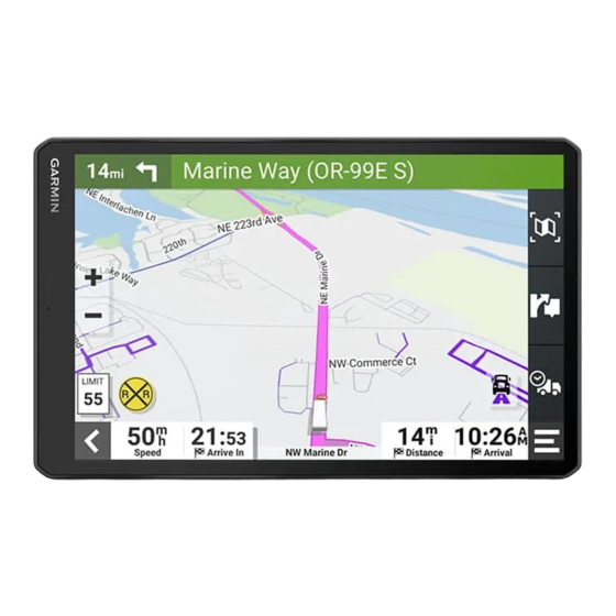
Page 28: Your Route On The Map
Your route on the map As you travel, the device guides you to your destination using voice prompts and information on the map. Instructions for your next turn or exit, or other actions appear across the top of the map. Next action in the route. -
Page 29: Viewing Popular Lorry Paths On The Map
Viewing Popular Lorry Paths on the Map You can enable the device to highlight popular lorry paths on the map. This can be useful to help you choose roads that are more accessible for your vehicle. From the map, select . Active lane guidance As you approach some turns, exits, or interchanges in your route, a detailed simulation of the road appears beside the map, if available. -
Page 30: Arriving At Your Destination
Arriving at your destination When you approach your destination, the device provides information to help you complete your route. • indicates the location of your destination on the map, and a voice prompt announces you are approaching your destination. • When you approach some destinations, the device automatically suggests parking areas. You can select More to view a full list of suggested parking areas (Parking Near Your Destination, page 25). -
Page 31: Parking Near Your Destination
Parking Near Your Destination Your device can help you find a parking spot near your destination. When you approach some destinations, the device automatically suggests parking areas. NOTE: this feature should be used only when you are using the car vehicle profile. While using a lorry vehicle profile, you can search for lorry parking near your destination (Finding lorry parking, page 18). -
Page 32: Changing The Route Calculation Mode
Changing the route calculation mode 1 Select Settings > Navigation > Calculation Mode. 2 Select an option: • Select Faster Time to calculate routes that are faster to drive, but can be longer in distance. • Select Off Road to calculate point-to-point routes (without roads). Stopping the route From the map, select >... -
Page 33: Using The Map
Avoiding a road 1 Select Settings > Navigation > Custom Avoidances. 2 If necessary, select Add Avoidance. 3 Select Add Avoid Road. 4 Select the starting point of the section of road to avoid and select Next. 5 Select the ending point of the road section and select Next. 6 Select Done. -
Page 34: Map Tools
(Using in-call options, page 37). Weather: displays weather conditions for your area. Garmin eLog: displays hours of service information from the Garmin eLog app. Music Controls: displays media controls and media information. PrePass ®: shows notifications for upcoming weighbridges and bypass... -
Page 35: Customising The Up Ahead Categories
Customising the up ahead categories You can change the location categories that appear in the Up Ahead tool. 1 From the map, select > Up Ahead. 2 Select a category. 3 Select 4 Select an option: • To move a category up or down in the list, select and drag the arrow next to the category name. •... -
Page 36: Restriction Warnings
Restriction warnings Height Weight Axle Weight Length Width No Lorries Allowed No Trailers Allowed Material Restrictions No Flammables or Explosives Allowed No Water Pollutants Allowed No Left Turn No Right Turn No U-Turn Road condition warnings Risk of grounding Lateral wind Narrow road Sharp curve Steep downhill... -
Page 37: Alerts
Alerts Weighbridge Road not verified for lorries Trip information Viewing trip data from the map Before you can view trip data on the map, you must add the tool to the map tools menu. From the map, select > Trip Data. Viewing Customised Trip Information on the Map You can use the trip data map tool to show customised trip information on the map. -
Page 38: Resetting Trip Information
• Select Reset Trip B to reset the odometer. Viewing upcoming traffic NOTICE Garmin is not responsible for the accuracy or timeliness of the traffic information. Before you can use this feature, your device must be receiving traffic data (Traffic, page 38). -
Page 39: Changing The Map Perspective
2 Turn on your dēzl device and place the device and your smartphone within 3 m (10 ft.) of each other. 3 On your phone, open the dēzl app. 4 Follow the on-screen instructions to sign in to a Garmin account and complete the pairing and setup process. -
Page 40: Disabling Bluetooth Features (Iphone®)
Disabling Bluetooth features (iPhone ® By default, all compatible Bluetooth features are enabled when you pair your phone. You can disable specific Bluetooth features and remain connected to the other features. 1 Select > Wireless Networks. 2 Select an option: •... -
Page 41: Receiving Notifications
Receiving notifications WARNING Do not read or interact with notifications while driving, because doing so can cause distraction that could lead to an accident resulting in serious personal injury or death. Before you can use this feature, your device must be connected to a supported phone running the dēzl app (Live services, traffic and smartphone features, page 33). -
Page 42: Going To An Address Or Location Using The Dēzl App
Going to an address or location using the dēzl app You can use the dēzl app to search for an address, business or point of interest and send it to your dēzl device for navigation. 1 From the dēzl app, select Where To?. 2 Select an option: •... -
Page 43: Using The Call History
Using the call history Your call history is loaded from your phone to the device each time your phone and the device connect. It may take a few minutes for the call history to be available. Some phones do not support this feature. 1 Select >... -
Page 44: Traffic
Traffic data is not available in all areas. For information about traffic coverage areas, go to garmin.com/traffic. Receiving traffic data using your smartphone Your device can receive subscription-free traffic data while connected to a smartphone running the dēzl app. -
Page 45: Enabling Traffic
Carrier Safety Administration (FMCSA) regulations. Drivers should comply with all applicable hours-of-service requirements. When integrated with a Garmin eLog compliant Electronic Logging Device (ELD), the Garmin eLog device enables a motor carrier to comply with hours of service logging and break requirements. For more information, or to purchase a Garmin eLog device, go to garmin.com/elog. -
Page 46: Starting The Break Timer
Setting Up Your Garmin eLog Device You must set up and pair your Garmin eLog adapter with the Garmin eLog app in order to use the device. 1 From the app store on your mobile device, install and open the Garmin eLog app. -
Page 47: Viewing Garmin Elog Information On Your Dēzl Device
(Setting Up Your Garmin eLog Device, page 40). As you drive your vehicle, the device displays your duty status and total drive hours in the Garmin eLog map tool. Select a field to view a summary of remaining drive hours. -
Page 48: Editing Fuel Data
Editing fuel data 1 Select > IFTA > Fuel Journals. 2 If necessary, select a vehicle profile. 3 If necessary, select a quarter. 4 Select a fuel record. 5 Select an option: • Select a field to edit the information. •... -
Page 49: Logging Service History
Logging service history You can log the date and odometer reading when service or maintenance is performed on your vehicle. The device provides several service categories, and you can add custom categories (Adding service categories, page 43). 1 Select > Srvice History. 2 Select a service category. -
Page 50: Prepass
® NOTICE Garmin is not responsible for the accuracy or timeliness of the information provided by the PrePass app. NOTE: Before you can use this feature, you must have an active PrePass account. The PrePass app enables drivers to verify the safety, credentials, and weight of a commercial vehicle with upcoming weigh stations. -
Page 51: Placing A Phone Call Using Your Voice
Viewing the Weather Forecast NOTICE Garmin is not responsible for the accuracy or timeliness of the weather data. Before you can use this feature, your device must be receiving weather data. You can connect your device to the dēzl app to receive weather data (Live services, traffic and smartphone features, page 33). -
Page 52: Viewing Weather Alerts
Viewing weather alerts Before you can use this feature, your device must be connected to a supported phone running the dēzl app (Live services, traffic and smartphone features, page 33). NOTE: this feature is not available in all areas. While you are travelling with your device, weather alerts may appear on the map. You can also view a map of weather alerts near your current location or near a selected town. -
Page 53: Changing Routing Options For A Route
Changing Routing Options for a Route You can customise how the device calculates your route. 1 Select > Route Planner. 2 Select a saved route. 3 Select 4 Select an option: • To add shaping points to your route, select Shaping and select at least one location. •... -
Page 54: Viewing Photolive Traffic Cameras On The Map
Viewing photoLive Traffic Cameras on the Map The photoLive map tool shows traffic cameras from the road ahead of you. 1 From the map, select > photoLive. The device shows the live image from the nearest traffic camera on the road ahead, along with the distance to the camera. -
Page 55: Garmin Powerswitch™ App
Displays Garmin PowerSwitch device tabs and custom layout tabs Activating a Power Switch Before you can use the Garmin PowerSwitch app to activate a switch, you must install your Garmin PowerSwitch device in your vehicle and pair it with the Garmin PowerSwitch app. -
Page 56: Customising A Button
Before you can use control input functions, you must connect a control input to your Garmin PowerSwitch device. You can assign one or more switches to turn on when the Garmin PowerSwitch device receives a signal from a control input. -
Page 57: Routines
Routines Routines automate your Garmin PowerSwitch device. When you define a routine on your compatible Garmin navigation device, it turns switches on or off automatically when the conditions of the routine are met. For example, you can set a routine to turn on a switch at specific time each day or when your vehicle reaches a specific speed. -
Page 58: Settings
Enabling maps You can enable map products installed on your device. TIP: to purchase additional map products, go to http://buy.garmin.com. 1 Select Settings > Map & Vehicle > myMaps. 2 Select a map. -
Page 59: Navigation Settings
Navigation settings Select Settings > Navigation. Calculation Mode: sets the route calculation method. Avoidances: sets road features to avoid on a route. Custom Avoidances: allows you to avoid specific roads or areas. Environmental Zones: sets the avoidance preferences for areas with environmental or emissions restrictions that may apply to your vehicle. -
Page 60: Wireless Network Settings
Alerts: sets the type of proximity points for which alerts are played. Backup camera settings The backup camera settings allow you to manage paired Garmin backup cameras and camera settings. This menu appears on your navigation device only when the device is connected to a wireless camera receiver cable. -
Page 61: Display Settings
Display settings Select > Display. Colour Mode: allows you to select day or night colour mode. If you select the Auto option, the device automatically switches to day or night colours based on the time of day. Brightness: allows you to adjust the display brightness. Display Timeout: allows you to set the amount of idle time before your device enters sleep mode while using battery power. -
Page 62: Resetting Data And Settings
• Connect the device to an optional power adapter accessory, such as a wall power adapter. You can purchase an approved Garmin AC-DC adapter suitable for home or office use from a Garmin dealer or www.garmin.com. The device may charge slowly when connected to a third-party adapter. -
Page 63: Map And Software Updates
• You can connect the device to a Wi‑Fi network to update directly on the device (recommended). This option allows you to update your device conveniently without connecting it to a computer. • You can connect the device to a computer and update it using the Garmin Express application (garmin.com /express). -
Page 64: Updating Maps And Software Using A Wi-Fi Network
TIP: if a map update is interrupted or cancelled before it completes, your device may be missing map data. To repair missing map data, you must update the maps again using either Wi‑Fi or Garmin Express. Device maintenance... -
Page 65: Updating Maps And Software With Garmin Express
Updating Maps and Software with Garmin Express You can use the Garmin Express application to download and install the latest map and software updates for your device. 1 If you do not have the Garmin Express application installed on your computer, go to garmin.com/express... -
Page 66: Device Care
• To install a specific update, click View Details and click Install next to the update you want. The Garmin Express application downloads and installs the updates onto your device. Map updates are very large and this process may take a long time on slower internet connections. -
Page 67: Restarting The Device
Restarting the Device You can restart your device if it stops functioning. Hold the power key for 12 seconds. Removing the Device, Mount and Suction Cup Removing the Device from the Mount 1 Press the release tab or button on the mount. 2 Tilt the bottom of the device upward, and lift the device from the mount. -
Page 68: My Device Is Not Acquiring Satellite Signals
Incorrectly wiring the power cable can result in damage to the vehicle or the battery and can cause bodily injury. You can use a connected Garmin PowerSwitch device to control lights, fans and more from your dēzl device. Mounting Considerations •... -
Page 69: Mounting The Device
Avoid wires, gauges, air bags, air bag covers, heating, ventilation, and air conditioning and other items when drilling pilot holes and attaching the mount to the vehicle. Garmin is not responsible for any damages or consequences arising from the installation. -
Page 70: Opening The Front Cover
Opening the Front Cover You must open the front cover to make electrical connections. 1 Lift the front cover latch and rotate it anticlockwise. 2 Pull the front cover off of the device. Appendix... -
Page 71: Connecting Accessories
Accessory requirements: • Verify the amperage rating of each accessory before wiring it to the Garmin PowerSwitch device. The device supports accessories up to 30 A for each channel and a maximum of 100 A for the entire system. -
Page 72: Connecting A Control Input
CAUTION Do not connect the accessory ground wires to the ground terminal (GND) on the Garmin PowerSwitch device, as doing so could result in personal injury or property damage, or could negatively impact device functionality. 3 Verify that all electrical connections are tight and will not come loose during use. -
Page 73: Pairing With A Garmin Navigation Device
The Garmin PowerSwitch device turns off all outputs automatically to preserve your vehicle's battery if it is receiving less than 11 V of power (My accessories are not receiving power, page 68). The device withstands incidental exposure to water of up to 1 m for up to 30 min. For more information, go to www.garmin.com/waterrating. Appendix... -
Page 74: Installing A Memory Card For Maps And Data
• Verify that your vehicle's battery is supplying at least 12 V of power. The Garmin PowerSwitch device turns off all outputs automatically to preserve your vehicle's battery if it is receiving less than 11 V of power. Outputs turn back on when the device detects more than 12 V of power. -
Page 75: Transferring Data From Your Computer
3 Select a file. 4 Select Edit > Copy. 5 Browse to a folder on the device. NOTE: for a removable drive or volume, you should not place files in the Garmin folder. 6 Select Edit > Paste. Disconnecting the USB cable If your device is connected to your computer as a removable drive or volume, you must safely disconnect your device from your computer to avoid data loss. - Page 76 June 2022 GUID-CB6B72DC-B946-4D6C-84F3-440DCE3A7256 v1...