Garmin GPSMAP 276C Owner's Manual
Chartplotting receiver
Hide thumbs
Also See for GPSMAP 276C:
- Owner's manual (136 pages) ,
- Quick reference manual (2 pages) ,
- Declaration of conformity (1 page)
Table of Contents
Advertisement
Quick Links
Advertisement
Table of Contents

Related Manuals for Garmin GPSMAP 276C


Summary of Contents for Garmin GPSMAP 276C
- Page 1 GPSMAP 276C ® chartplotting receiver owner’s manual...
- Page 2 All rights reserved. Except as expressly provided herein, no part of this manual may be reproduced, copied, transmitted, disseminated, downloaded, or stored in any storage medium, for any purpose without the express prior written consent of Garmin. Garmin hereby grants permission to download a single copy of this manual onto a hard drive...
- Page 3 Take a moment to compare the contents of this package with the packing list on the outside of the box; if any pieces are missing, contact your Garmin dealer immediately. About This Manual To get the most out of your new navigation system, take time to read this manual and learn the operating procedures for your unit.
-
Page 4: Table Of Contents
NTRODUCTION ABLE OF ONTENTS Table of Contents Introduction ...i Caring for the GPSMAP 276C ... iv Warning ... v Caution ... vi Getting Started ...1 Unit Overview ... 1 Charging the GPSMAP 276C ... 2 Turning On the GPSMAP 276C ... 3 Getting Satellite Signals ... - Page 5 Optional Accessories ... 102 Installation Information ... 103 Learning About GPS ... 107 LORAN TD Setup ... 109 Map Datums and Location Formats ...111 GPSMAP 276C Owner’s Manual NTRODUCTION Digital Selective Calling (DSC) ... 112 Messages ... 114 Data Field Options ... 116 Software License Agreement ...
-
Page 6: Caring For The Gpsmap 276C
Cleaning the Screen The GPSMAP 276C screen should be cleaned using a soft, clean, lint-free cloth. Water, isopropyl alcohol, or eyeglass cleaner can be used if needed. If these are used, apply the liquid to the cloth and then gently wipe the screen with the moistened cloth. -
Page 7: Warning
field of deployment. Always operate the vehicle in a safe manner. Do not become distracted by the GPSMAP 276C while driving, and always be fully aware of all driving conditions. Minimize the amount of time spent viewing the screen of the GPSMAP 276C while driving and use voice prompts when possible. -
Page 8: Caution
Map Data Information: One of the goals of Garmin is to provide customers with the most complete and accurate cartography that is available to us at a reasonable cost. We use a combination of governmental and private data sources, which we identify in product literature and copyright messages displayed to the consumer. -
Page 9: Getting Started
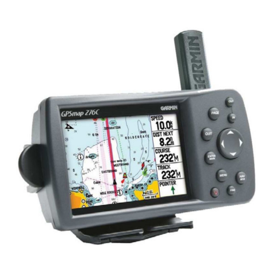
Unit Overview The GPSMAP 276C is an all-in-one, versatile color chartplotter and automobile navigator—perfect for land or water. This portable GPS navigator features a 256-color TFT display that is easy to read in bright sun, a built-in basemap, and auto routing to provide you with automatically generated turn-by-turn directions. -
Page 10: Charging The Gpsmap 276C
Charging the GPSMAP 276C Before using the unit, you might need to charge the battery in the GPSMAP 276C. Plug the unit into an external power source to charge. You can use the unit while it is charging. To charge the unit’s battery: 1. -
Page 11: Turning On The Gpsmap 276C
Turning On the GPSMAP 276C The first time you turn on your new GPSMAP 276C, the GPS receiver must collect satellite data and establish its current location. To ensure proper initialization, the GPSMAP 276C is shipped from the factory in AutoLocate mode, which allows the receiver to “find itself”... -
Page 12: Getting Satellite Signals
ATELLITE IGNALS Getting Satellite Signals After you turn on the GPSMAP 276C, the unit automatically begins searching for satellites. The GPS page appears while the unit is gathering satellite signals and acquiring a fix, which should take only a few minutes. While the GPSMAP 276C is getting satellite signals, the GPS page shows the status as “Acquiring Satellites.”... -
Page 13: Receiver Status
• Green signal strength bars—the receiver has collected the necessary data from this satellite. When the GPSMAP 276C collects the necessary data from the best satellites in view to calculate a fix, the status field indicates the status of the receiver. The unit then updates the location, date, and time. -
Page 14: Gps Options
As soon as the receiver gathers enough satellite information, your proper location appears on the map. Any time you have traveled more than 600 miles with the GPS receiver turned off, the receiver may take longer than normal to initialize and find your location. - Page 15 • Press twice to open the Main Menu. POWER Key • Press and hold to turn the unit on or off. • Press and release to adjust the backlighting and external speaker volume. GPSMAP 276C Owner’s Manual ETTING TARTED SING THE IN and OUT Keys •...
-
Page 16: Using The Gpsmap 276C
This section explains how to enter and select information with the GPSMAP 276C. Understanding Terms The GPSMAP 276C’s advanced keypad system is designed to allow quick, convenient selection of navigation options and data entry. As you progress through this owner’s manual, you are directed to press a specific key or highlight a field on the screen. -
Page 17: Selecting Options And Entering Data
3. Press ENTER to select the feature. Another window with more options might appear. If so, select an option, and press ENTER again. Selecting an option from an options menu GPSMAP 276C Owner’s Manual ETTING TARTED To exit a menu or return to the previous setting: Press QUIT. -
Page 18: Using The Databases
3. Highlight Restore Default, and press ENTER. Using the Databases Optional Garmin data cards and MapSource CD-ROMs enhance the versatility of your GPSMAP 276C. With optional MapSource City Select data, you can view listings of nearby restaurants, lodging, shopping centers, attractions and entertainment, and even retrieve addresses and phone numbers for any listed location. -
Page 19: Simulator Mode
Simulator Mode To help you get to know your GPSMAP 276C, you can use the unit in Simulator Mode. Simulator Mode is helpful for practicing with the unit indoors or when no satellite signals are available. All waypoints and routes created in Simulator Mode are retained in memory for future use. -
Page 20: Basic Operation In Marine Mode
The following examples show the main pages in Marine Mode with optional MapSource BlueChart detailed maps. Marine Mode is the default mode for the GPSMAP 276C. This manual first addresses the page, such as the Map Page, as it appears in Marine Mode. The manual then describes the page as shown in Automotive Mode. -
Page 21: Navigating In Marine Mode
Marine Mode, you can initiate Man OverBoard (MOB) navigation, which places a waypoint in the location and then navigates you back to that location. You can also initiate navigation through the Find menu. GPSMAP 276C Owner’s Manual ASIC PERATION IN ARINE... - Page 22 Tide Stations from this list. The steps vary only slightly from those listed for Waypoints.) 4. Select a waypoint from the list, and press ENTER to open the Waypoint Review Page. 5. With the Go To button highlighted, press ENTER to begin navigation. Waypoint Review Page GPSMAP 276C Owner’s Manual...
- Page 23 5. Press ENTER when the Go To button is highlighted. For complete information about finding an item, see the Item” section. GPSMAP 276C Owner’s Manual ASIC PERATION IN Man OverBoard (MOB) Use the MOB function to simultaneously mark your current location and create a direct route back to that location for quick response to emergency situations.
-
Page 24: Finding An Item
3. Using the ROCKER, highlight an item from the list, and press ENTER. The item’s information page automatically opens, allowing you to save the item as a waypoint, show the item on the map, or automatically create a route to (Go To) the item. GPSMAP 276C Owner’s Manual... -
Page 25: Recently Found Items
Find From list. 5. Select a reference location on the map, and press ENTER. The list shows items nearest to the new map location. GPSMAP 276C Owner’s Manual ASIC PERATION IN To find an item near another item: 1. -
Page 26: Find Menu Options
Near Next—compiles the Find items lists based on the next turn in the route. Near Destination—compiles the Find items lists based on the route destination. Near Current Route—compiles the Find items lists based on the active route. GPSMAP 276C Owner’s Manual... -
Page 27: Creating And Using Routes
Creating and Using Routes Use the GPSMAP 276C to create and store up to 50 reversible routes, with up to 300 points each. Creating a Route Use the Route tab on the Main Menu to create routes. You can create routes two ways. -
Page 28: Navigating A Saved Route
1. In Automotive Mode, press the NAV key. 2. Use the ROCKER to highlight Navigate Route, and press ENTER. 3. Highlight a route, and press ENTER. Select a route from list Select the route you want to take. GPSMAP 276C Owner’s Manual... -
Page 29: Editing A Route
Route name here Route Review Page 4. Use the ROCKER to enter the route name, and press ENTER. GPSMAP 276C Owner’s Manual ASIC PERATION IN ARINE To review individual route points: 1. Press MENU twice to open the Main Menu. Highlight the Route tab. - Page 30 6. If the New Waypoint Page opens, edit the waypoint as needed, highlight OK, and press ENTER. 7. Repeat steps 4 through 6 until all points are added to the route. Press QUIT when finished. Editing the route on the map GPSMAP 276C Owner’s Manual...
-
Page 31: Manually Transitioning To The Next Waypoint
You can enter information about your trip so the GPSMAP 276C can estimate information about your trip. To plan your route: 1. Open the Route Review Page options menu. 2. Highlight Plan Route, and press ENTER. Entering Speed and Fuel Flow for trip planning 3. -
Page 32: Creating And Using Waypoints
Find menu, and then store them in the unit before ever leaving home. The GPSMAP 276C stores up to 3,000 alphanumeric waypoints with a user-defined icon, comment, elevation, depth, and temperature available for each waypoint. Waypoints can be created using three basic methods: •... -
Page 33: Creating Waypoints Using The Map
You can quickly create a waypoint using the Map Page. When you pan the map and move the arrow over a map item, you see a highlighted description of that item. The GPSMAP 276C uses the map item text shown on the map as the default name and symbol for the new waypoint. -
Page 34: Creating A Waypoint By Entering Coordinates
ENTER when finished. To change any other information on the New Waypoint Page, highlight the appropriate field, and press ENTER. After entering your changes, highlight OK, and press ENTER. Entering location coordinates.. GPSMAP 276C Owner’s Manual... -
Page 35: Reviewing A Waypoint
MapSource or BlueChart feature, the Waypoint Review Page might include additional tabs containing information about the other features at that location. Waypoint Review Page GPSMAP 276C Owner’s Manual ASIC PERATION IN ARINE To access the Waypoint Edit Page: 1. -
Page 36: Adding A Waypoint To A Route
Average Location makes the unit take several sample location measurements for the waypoint and recalculate for a more accurate location reading. NOTE: You must have a GPS satellite fix before you can average a waypoint’s location. To calculate the average location: 1. -
Page 37: Projecting A Waypoint
3. Highlight the Points tab. 4. Press MENU to open the New Waypoint Page options menu. 5. Highlight Project Location, and press ENTER. Project Location Menu Enter the distance, bearing, and location. GPSMAP 276C Owner’s Manual ASIC PERATION IN ARINE REATING AND 6. -
Page 38: Editing A Waypoint
1. After you edit the waypoint on the Waypoint Edit Page (shown above), highlight Next, and press ENTER. The Waypoint list appears with the next waypoint highlighted. 2. Press ENTER to edit that waypoint. Name field Waypoint Page GPSMAP 276C Owner’s Manual... -
Page 39: Organizing Waypoints Into Categories
2. Select Edit Categories, and press ENTER. The Waypoint Categories window opens. 3. Highlight Add, and press ENTER. Adding a new category GPSMAP 276C Owner’s Manual ASIC PERATION IN ARINE 4. Use the ROCKER to enter a name for the category. -
Page 40: Deleting Waypoints
To delete waypoints by symbol or category: 1. On the User sub tab, highlight the waypoint you want to delete, and press MENU. 2. Highlight either Delete by Symbol or Delete by Category, and press ENTER. Deleting a waypoint GPSMAP 276C Owner’s Manual... -
Page 41: Proximity Points
OK is highlighted, press ENTER. 5. Highlight Delete, and press ENTER to delete all waypoints within the set location. Choose Cancel or press QUIT to exit without deleting the waypoints. GPSMAP 276C Owner’s Manual ASIC PERATION IN ARINE Proximity Points Use the Proximity sub tab to define an alarm circle around a stored... - Page 42 4. To clear a single alarm, highlight Remove Point, and press ENTER. To clear all proximity waypoints, select Remove All, and press ENTER. 5. Use the ROCKER to highlight OK, and press ENTER to confirm. Proximity Points Tab Options Menu GPSMAP 276C Owner’s Manual...
-
Page 43: Managing Your Tracks
Map Page as you travel. The track log contains points along its path, including time, and location for each point. The track log starts recording as soon as the GPSMAP 276C gets a location fix. For the best results, clear the track log before you start traveling because when the track log is full, new track points overwrite the oldest track points. - Page 44 6. Select an ending point, and press ENTER. The Track Review Page automatically opens. 7. Highlight OK and press ENTER to save the track. 8. Press QUIT to exit. Saving a portion of the track log GPSMAP 276C Owner’s Manual...
-
Page 45: Saved Tracks
To edit a track: 1. Press MENU twice to open the Main Menu. 2. Highlight the Track tab. Press right on the ROCKER to highlight the Saved sub tab. GPSMAP 276C Owner’s Manual ASIC PERATION IN ARINE 3. Highlight the track you want to edit, and press ENTER. The Track Review Page opens. -
Page 46: Navigating A Saved Track
(TracBack to), and press ENTER. RACKS TracBack Tips When a TracBack is initiated, the GPSMAP 276C divides the track into segments called legs. Up to 300 temporary turns are created to mark the most significant features of the track in order to duplicate your exact path as closely as possible. -
Page 47: Following A Marine Route
Following a Marine Route After you activate a route, the GPSMAP 276C automatically starts guiding you to the destination using a variety of tools and pages. See Your Route on the Map Page You can track the progress of your route on the Map Page. Your route is shown with a magenta line. - Page 48 To stay on course, steer toward the violet bar (or arrows) until it is aligned with the red bar. For more information, see the section beginning on page “Position Data Page” section Position Data Page GPSMAP 276C Owner’s Manual...
-
Page 49: Marine Mode Pages And Features
GPSMAP 276C always turns on in position mode, with the last known location centered on the map. When you press the ROCKER, the GPSMAP 276C enters pan mode, which moves the map to keep the white arrow (map pointer) within the display area. - Page 50 2. Highlight Set Up Map, and press ENTER. 3. Press left or right on the ROCKER to highlight a tab; press up or down on the ROCKER to highlight to the field you want to change, and press ENTER. Changing a data field GPSMAP 276C Owner’s Manual...
- Page 51 4. Press up or down on the ROCKER to highlight a setting, and press ENTER. 5. Press PAGE or QUIT to exit. Additional Map Data You can view the data currently loaded on your GPSMAP 276C unit and data card. To review/change map information: 1. On the Map Page, press MENU.
-
Page 52: Zooming In And Out Of The Map
The system has a built-in worldwide database, with more detailed coverage available through the use of the BlueChart or MapSource data. The GPSMAP 276C shows cartography as long as chart information is available for the zoom scale you selected. Map coverage conforms to the following conditions: •... -
Page 53: Panning The Map
To pan the map: Press up, down, right, or left on the ROCKER. The panning arrow moves the map so you can view different parts of the map. GPSMAP 276C Owner’s Manual ARINE AGES AND Map feature highlighted... -
Page 54: Clearing Unwanted Details From The Map
To declutter the Map Page: 1. On the Map Page, press MENU to open the options menu. 2. Highlight Declutter, and press ENTER. 3. Press ENTER again to restore the detail to the map display. Map Feature Information Page GPSMAP 276C Owner’s Manual... -
Page 55: Compass Page
5. Press QUIT to finish. GPSMAP 276C Owner’s Manual ARINE Compass Page During active navigation, the Compass Page guides you to your destination with a graphic compass display and a bearing pointer. -
Page 56: Using The Marine Timer
finally a one-minute final countdown. Then during the race, mariners might want to count up to keep track of their time. By default, all of these different count downs and count ups can easily be performed with the GPSMAP 276C by pressing a few buttons. GPSMAP 276C Owner’s Manual... - Page 57 2. Press ENTER to start the timer. Use the ROCKER during the timing to quickly select a different length of time. 3. Press ENTER to stop timing. GPSMAP 276C Owner’s Manual ARINE AGES AND Marine Timer on the Compass Page As discussed previously, the timer is set to count down five minutes.
-
Page 58: Highway Page
Nearby waypoints not in the active route can also be shown. You can zoom in or out to display a larger or smaller view of the highway. To change the highway perspective scale: Press IN to zoom in; press OUT to zoom out. GPSMAP 276C Owner’s Manual... - Page 59 1. Press PAGE repeatedly until the Highway Page appears. 2. Press MENU. 3. Use the ROCKER to highlight an option, and press ENTER. Highway Page Options Menu GPSMAP 276C Owner’s Manual ARINE AGES AND The following options are available from the Highway Page options menu: Set Up Page Layout—choose the number of data fields that appear...
-
Page 60: Active Route Page
EATURES CTIVE Active Route Page When you initiate a route in the GPSMAP 276C, the Active Route Page shows each point (waypoint or map item) of the active route, with the point name, Course, Distance, and several other fields of information. The current destination point, the active point, is marked with an arrow icon. -
Page 61: Position Data Page
Press PAGE repeatedly to open the Position Data Page. Your present location is 5.6 nm west of Coronado, CA Position Data Page GPSMAP 276C Owner’s Manual ARINE AGES AND EATURES Position Data Page Options With the Position Data page open, press MENU to open the options menu. -
Page 62: Basic Operation In Automotive Mode
UTOMOTIVE This section discusses some of the more common Automotive operations you will perform with your GPSMAP 276C in Automotive Mode. Please note that many common operations, such as marking a waypoint and creating a route, are performed the same way as in Marine Mode. -
Page 63: Navigating In Automotive Mode
• Press the NAV key to activate a new route using the Find Menu, or activate a saved route or track. • Press the FIND key to search for a particular item and create a route to it. GPSMAP 276C Owner’s Manual ASIC PERATION IN UTOMOTIVE... - Page 64 3. Highlight the item you want from the list, and press ENTER. 4. Highlight the Go To button, and press ENTER. For complete information about finding an item, see the Item” section on page 16. “Finding an GPSMAP 276C Owner’s Manual...
-
Page 65: Following A Saved Route
5. Highlight Follow Roads, and press ENTER to create a turn-by-turn route (auto-route), which appears on the Current Route Page. You can also initiate a saved route from the Route tab on the Main Menu. GPSMAP 276C Owner’s Manual ASIC PERATION IN UTOMOTIVE Stopping and Resuming Navigation At any time when you are navigating to a point, you can stop navigation. -
Page 66: Editing Your Route
7. When finished, highlight the OK button, and press ENTER. Creating a Detour If there is road construction or some other form of a detour while navigating a route, you can have your GPSMAP 276C create a detour route for you. To create a detour: 1. - Page 67 1. While navigating your route, press NAV to open the Navigate menu. 2. Use the ROCKER to select Edit Vias, and press ENTER. The Add/Edit Vias window opens. 3. Highlight Add Via Point, and press ENTER. GPSMAP 276C Owner’s Manual ASIC PERATION IN UTOMOTIVE Add/Edit Vias Page Showing the original route without Via Points 4.
-
Page 68: Following An Automotive Route
UTOMOTIVE OLLOWING AN Following an Automotive Route The GPSMAP 276C guides you to your destination using many tools, such as the Map Page and Current Route Page. Track Your Progress with the Map Page You can track the progress of your route on the Map Page. Your route is shown with a magenta line. -
Page 69: Automotive Mode Pages And Features
The top of the screen shows the GPS status or the route leg. You can also add data fields to the page or select a full-screen map without data fields. -
Page 70: Current Route Page
AGES AND EATURES Current Route Page Whenever you activate a route in the GPSMAP 276C in Automotive Mode, the Active Route Page shows each turn of the active route, with the distance to the turn, the street name, and estimated time to arrival and time of arrival. -
Page 71: Trip Computer Page
Trip Computer Page Reset the Trip Computer before beginning a trip. If you make frequent stops, leave the GPSMAP 276C turned on in order to receive satellites. This allows the unit to accurately measure elapsed time during the trip. -
Page 72: Main Menu
The Main Menu on the GPSMAP 276C provides access to various waypoint, system, navigation and interface management, and setup menus. The Main Menu is accessible from any page by pressing the MENU key twice. Main Menu To select a tab from the Main Menu: 1. -
Page 73: Route Tab
“Creating and Using Routes” beginning on page for more information about routes. Main Menu—Route Tab GPSMAP 276C Owner’s Manual Points Tab The Points tab contains two sub tabs, User and Proximity, which section allow you to manage a large number of waypoints quickly and efficiently. -
Page 74: Track Tab
DSC Tab The DSC tab (Marine Mode only) allows you to control and set up the Digital Selective Calling (DSC) features on the GPSMAP 276C. DSC uses marine VHF radio and GPS technologies to transmit and receive location information. DSC is used by mariners for two major operations: distress calls and position reporting. -
Page 75: Understanding Distress Calls
Understanding Distress Calls With your GPSMAP 276C properly connected to a VHF radio with DSC output, you can receive any DSC distress call within range. An alert message appears and a tone sounds when a distress call is received. The alarm only sounds on a distress call; position reports do not sound the alarm. -
Page 76: Receiving A Position Report Or Distress Call
The DSC Directory acts much like a phone book and can hold up to 50 entries. Pressing MENU from this page allows you to add a New Item, Delete a highlighted entry, or Delete All entries. GPSMAP 276C Owner’s Manual... -
Page 77: Making A Distress Call
Another way to input a name is from the Entry Review Page or the DSC Distress Call or DSC Position Report pages. The Name and MMSI are sent to other Garmin GPS units: Only the MMSI numbers are sent to other non-Garmin DSC users. -
Page 78: Sonar Tab
DSC Setup Sonar Tab The Sonar tab contains options for the Sonar Page. See the Up and Using Sonar” section beginning on page information about Sonar setup options. Main Menu—Sonar Tab GPSMAP 276C Owner’s Manual “Setting for more... -
Page 79: Alarms Tab
ENTER. If necessary, highlight the next field to the right, and press ENTER, specify the settings you want, and press ENTER to finish. GPSMAP 276C Owner’s Manual To set a persistent alarm: 1. Press MENU twice to open the Main Menu. -
Page 80: Sonar Alarms
Select On and then enter a specific voltage. DGPS—sets an alarm to sound when the unit loses a differential fix. Accuracy—sets an alarm to sound when GPS accuracy falls outside of the user-set value. Select On and then enter a specific distance. Sonar Alarms The Sonar sub tab contains the following alarms: Shallow Water/Deep Water—sets an alarm to sound when you... -
Page 81: Calendar Tab
1. Press MENU twice to open the Main Menu. 2. Highlight the Calendar tab. The current day appears on the Day View sub tab. GPSMAP 276C Owner’s Manual 3. Press MENU to open the options menu. Highlight Add Route (or Add Point), and press ENTER. -
Page 82: Celestial Tab
The tide curve appears as a shaded area; higher tides are taller and lower tides are shorter. The bottom of the page indicates the times with the highest and lowest tides. GPSMAP 276C Owner’s Manual Time Smallest and largest tides... - Page 83 To use the current date again, highlight the Date field. Press MENU, highlight Use Current Date, and press ENTER. GPSMAP 276C Owner’s Manual To view a chart’s details for another time during the day (other than current time): 1.
- Page 84 1. Press MENU twice to open the Main Menu. 2. Press up or down on the ROCKER to highlight the Celestial tab. 3. Use the ROCKER to select the Hunt & Fish sub tab. GPSMAP 276C Owner’s Manual...
- Page 85 To use the current date again, highlight the Date field. Press MENU, highlight Use Current Date, and press ENTER. GPSMAP 276C Owner’s Manual To view hunt and fish information for a different location: 1. Use the ROCKER to highlight the From field, and press ENTER.
-
Page 86: Message Tab
Message Tab The Message tab shows a list of messages generated by the GPSMAP 276C. Use the ROCKER to scroll through the entire list of messages on the Log sub tab. Use the Log Filter sub tab to show only the message types that you want to view. -
Page 87: Display Tab
1. Press MENU twice to open the Main Menu. 2. Use the ROCKER to highlight the Display tab. Main Menu—Display Tab GPSMAP 276C Owner’s Manual The Display tab contains the following options: Color Mode—sets the display to Day, Night, or Auto color mode. -
Page 88: Sound Tab
Voice Language—sets the language for vocal prompts. Speaker Volume—sets the external speaker or headphone volume. Setup Tab To customize how your GPSMAP 276C looks, use the System tab to adjust certain system settings. System Sub Tab Use the System sub tab to control settings for system mode, speed filter, language, and external power. - Page 89 Text Language—sets the unit’s on-screen language. WAAS—allows you to enable or disable WAAS. External Power Off—indicates whether the GPSMAP 276C remains on (Stay On) or the unit turns off (Turn Off) when external power is removed from the unit.
- Page 90 (Automatic - Silent). You can turn the off-route recalculation Off. Next Turn Pop-up—turns the Next Turn pop-up window Off, or opens the window when you press NAV (Held NAV Key Only), opens automatically (Automatically Only), or Both. GPSMAP 276C Owner’s Manual...
- Page 91 Time sub tab. Time Sub Tab Time Zone—choose the time zone for your city so the GPSMAP 276C shows the correct local time. Select Other to enter a UTC Offset. If the wrong date appears, press MENU, highlight Set Date, and press ENTER.
-
Page 92: Location Sub Tab
Datums are used to describe geographic positions for surveying, mapping, and navigation and are not actual maps built in the unit. Only change the datum if you are using a map or chart that specifies a different datum. GPSMAP 276C Owner’s Manual... -
Page 93: Selecting A Different Heading Reference
Failure to update this setting can result in substantial differences between the information shown on your unit and external references, such as a magnetic compass. GPSMAP 276C Owner’s Manual Welcome Sub Tab Use the Welcome sub tab to enter information, such as your name and address, or a welcome message that appears when the unit is turned on. - Page 94 Serial Data Format—sets the data format to one of the following: • Garmin Data Transfer—provides the proprietary format used to exchange data with a computer or another Garmin GPSMAP 276C. Garmin Data Transfer is disabled when the USB is connected, and the unit automatically switches to USB format.
- Page 95 If you select GARMIN DGPS or RTCM In/NMEA Out format, you can control a differential beacon receiver directly from your GPSMAP 276C using the COM 1 sub tab. You can have the unit automatically scan for the DGPS beacon signal, or you can enter the beacon frequency and bit rate on the unit, and the information will be used to tune the beacon receiver.
-
Page 96: Advanced Nmea Output Setup
Use the Advanced NMEA Output Setup Page to set the output rate, change the precision of the Lat/Lon minutes, set Waypoint IDs to names or numbers, and turn on and off the GPS status, the GARMIN Proprietary sentences, and Waypoint/Route (WPL, RTE). -
Page 97: Setting Up And Using Sonar
Read the GSD 20 Sounder Module Installation Instructions to properly install the sounder module. When you turn on your GPSMAP 276C, the Sounder Module automatically turns on. NOTE: You MUST have a GSD 20 installed and connected to your GPSMAP 276C to use the sonar features. -
Page 98: Using The Sonar Page
Range, Zoom, View, Gain, Target Level, Whiteline, Frequency, Depth Line, Noise Reject, and Scroll. Use the ROCKER and ENTER keys to make all adjustments. The currently selected option appears in the upper-left corner. “Understanding Sonar” section beginning on page GPSMAP 276C Owner’s Manual... -
Page 99: Adjustment Options
You can also press MENU and highlight a shortcut setting to quickly change to commonly used settings and values. Press ENTER to accept the new setting (or press QUIT to cancel) and return to the Sonar Page. Sonar Adjustments GPSMAP 276C Owner’s Manual ETTING UP AND SING ONAR Adjustment Options Scroll—adjusts the rate that the sonar display scrolls from right to... - Page 100 The Noise Reject can be turned Off, set to Normal (automatically adjusts for optimum viewing) or to a fixed 1–100% setting. When setting the Noise Reject, remember that a higher noise rejection setting is less likely to show fish or structures. for more information. GPSMAP 276C Owner’s Manual...
-
Page 101: Setting Up Sonar
4. When you are done making changes, highlight OK, and press ENTER. 5. To return to the standard Sonar Page, press QUIT; or press MENU, highlight Hide Pointer, and press ENTER. GPSMAP 276C Owner’s Manual ETTING UP AND SING Setting Up Sonar Use the Sonar tab on the Main Menu to set up the Sonar Page. -
Page 102: Calibrating The Water Speed
Speed shown on your unit is accurate. The calibration should take place in water having little or no current. The unit automatically uses the GPS ground speed, if it is available, for comparison on the calibration. If a GPS ground speed is not available, use either your boat’s speedometer reading (not always... -
Page 103: Setting Up The Sonar Display
“Water Speed Sensor Is Not Working” appears at the bottom of the screen. Check connections of speed sensor cables. GPSMAP 276C Owner’s Manual ETTING UP AND SING Setting Up the Sonar Display You can set up how the sonar information appears on-screen using the Display sub tab. -
Page 104: Viewing The Temperature
2. Highlight the Sonar tab, and then use ROCKER to select the Temperature sub tab. Depth scale in corners NOTE: You must be receiving proper sonar data from another device, such as a Garmin GSD 20 Sounder Module, to view temperature information. Temperature Sub Tab GPSMAP 276C Owner’s Manual... -
Page 105: Understanding Sonar
The transducer collects the reflected sound waves and sends the data to the GSD 20 Sounder Module and then to the GPSMAP 276C to be processed and displayed. The underwater data is shown on the Sonar display in the order that it is returned; first returned is the first on the display. -
Page 106: Understanding The Sonar Display
As shown in the drawing on the near right, the 40° cone angle produces a coverage area of approximately a 20-foot diameter circle at a 30- foot depth. Fish Tree Sonar Display GPSMAP 276C Owner’s Manual... - Page 107 6-foot diameter Coverage Depth circle at a 30-foot depth. Diameter Dual frequency mode combines both frequencies to get the best coverage area and contour/depth readings. 40° Cone Angle (50 kHz) 10° Cone Angle (200 kHz) GPSMAP 276C Owner’s Manual...
- Page 108 Thermoclines are shown as the weakest colors. One of the unique features offered by Garmin is See-Thru technology, which allows the GPSMAP 276C to hear both weak and strong signals simultaneously so it can identify fish returns under the toughest conditions, such as suspended in thermoclines or even hiding near structures.
-
Page 109: Appendix
5 to 15 hours depending on the backlight setting. Source: 11–35 VDC Fuse: 3AG - 1.5 Amp GPSMAP 276C Owner’s Manual Performance Receiver: Differential-ready 12 parallel channel receiver Acquisition Times: Approx. 15 seconds (warm start) Approx. 45 seconds (cold start) Approx. -
Page 110: Optional Accessories
16 MB, 32 MB, 64 MB, 128 MB, and 256 MB sizes. Download detailed map data from MapSource CD-ROMs to a data card, either directly through your GPSMAP 276C using the PC USB cable, the optional PC Interface cable, or with the optional USB Data Card Programmer. -
Page 111: Installation Information
GPSMAP 276C to auxiliary devices and removing the antenna. Connecting the Power/Data Cable The power/data cable connects the GPSMAP 276C to an 11–35 VDC system and provides interface capabilities for connecting external devices. The color code in the diagram below and to the right indicates the appropriate harness connections. -
Page 112: Information About Usb Drivers
NFORMATION Connecting Your GPSMAP 276C to a Computer You can connect your GPSMAP 276C to your computer using the supplied USB cable to connect to a USB data port or the optional PC Interface cable to connect to a DB-9 serial communications port. -
Page 113: Using Ximage For Customized Waypoint Icons
Installing and Removing Data Cards The GPSMAP 276C uses an optional Garmin data card to display digital charts and maps. Install the data card in the card slot located on the bottom of the unit. Install or remove the data card at any time, whether the unit is on or off. - Page 114 BNC connector is exposed and ready for use with an external antenna. For information on connecting an external antenna to the GPSMAP 276C, refer to the installation instructions that came with the antenna. To remove the GPS antenna: 1.
-
Page 115: Learning About Gps
GPS works in any weather conditions, anywhere in the world, 24 hours a day. There are no subscription fees or setup charges to use GPS. For more information see the Garmin Web site and read the GPS Guide for Beginners, which is found on the Web site at http://www.garmin.com/aboutGPS/manual.html. -
Page 116: What Is Waas
SBAS system should be capable of providing your GPS unit with increased accuracy at any location in the world. Currently, enabling WAAS on your Garmin GPSMAP 276C in regions that are not supported by ground stations may not improve accuracy, even when receiving signals from an SBAS satellite. -
Page 117: Loran Td Setup
Setup TD field, the active waypoint information will reflect those changes. Because the GPSMAP 276C does not rely on the LORAN signal for navigation, it can reference a different GRI chain or secondary stations and still navigate to the location stored in memory. - Page 118 TD coordinate anywhere in the world. You must know your GRI chain number and secondary stations to create a LORAN TD position. For more information, read our LORAN TD Position Format Handbook, available at the Garmin Web site, at www.garmin.com/support/userManual.html. GPSMAP 276C Owner’s Manual...
-
Page 119: Map Datums And Location Formats
Every chart has a map datum reference, and you can set the GPSMAP 276C to match most of those commonly used. If you are navigating and comparing the GPS coordinates to a map, chart, or other reference, set the map datum in the GPS unit to the same datum as the map to ensure the most accurate navigation. -
Page 120: Digital Selective Calling (Dsc)
Coast Guard when used in an emergency distress call. To obtain a MMSI number, users must register their VHF radio with the FCC (Form 605). Garmin does not supply this number! For more information regarding MMSI numbers, visit http://www.navcen.uscg.gov/marcomms/gmdss/mmsi.htm. -
Page 121: How Are Mmsi Assignments Obtained
DSC support. Any DSC- equipped mariner (on sea or land) within range can receive the call. When the GPSMAP 276C is connected to a VHF with DSC support, the GPS unit displays a call list, log, and a directory. Basic wiring is required for the Garmin unit and VHF radio to send and receive NMEA data from each other. -
Page 122: Messages
Memory Full—unit memory is full, no further data can be saved. Memory (RAM) Failed Unit Needs Repair—there is an internal problem with your unit. Contact Garmin Product Support to have the unit serviced. Memory (ROM) Failed Unit Needs Repair—there is an internal problem with your unit. - Page 123 Shallow Water—the water is shallower than the amount set in the Shallow Water Alarm. Sonar Failed Unit Needs Repair—there is an internal problem with the unit. Contact Garmin Product Support to have the unit serviced. Sunrise, Switching to Day Mode—the unit is switching to Day Mode. GPSMAP 276C Owner’s Manual Sunset, Switching to Night Mode—the unit is switching to Night Mode...
-
Page 124: Data Field Options
Elevation—the altitude (height) above or below mean sea level (MSL). GPS Status—the current status of the GPS receiver, such as “3D GPS.” Location (Lat/Lon)—your current location as latitude/longitude coordinates. Location (Selected)—your current location described in the selected units of measure (other than lat/lon). - Page 125 Appears as Move Timer. Trip Timer (Total)—the total time the unit has been tracking since the trip computer was reset. GPSMAP 276C Owner’s Manual Ttl Avg Spd—see Trip Avg. Speed (Total). Turn—the distance between Bearing (BRG) and Track (TRG). L indicates you should turn left.
-
Page 126: Software License Agreement
Registration link on our Home page. Use this area to record the serial number (8-digit number located on the back of the box) in case your GPSMAP 276C is lost, stolen, or needs service. Keep your original sales receipt in a safe place or attach a photocopy inside the manual. -
Page 127: Limited Warranty
Garmin dealer for repairs. The GPSMAP 276C is fastened shut with screws. Any attempt to open the case to change or modify the unit in any way will void your warranty and may result in permanent damage to the equipment. -
Page 128: Fcc Compliance
PPENDIX OMPLIANCE FCC Compliance The GPSMAP 276C complies with Part 15 of the FCC interference limits for Class B digital devices FOR HOME OR OFFICE USE. These limits are designed to provide more reasonable protection against harmful interference in a residential installation, and are more stringent than “outdoor” requirements. -
Page 129: Index
Waypoint 31, 32 Attention Tone 80 Caution vi AutoLocate 3, 5 CDI. See Course Deviation Indicator GPSMAP 276C Owner’s Manual Celestial Tab 74 Hunt & Fish sub tab 76 Data Card 45, 105 Sun & Moon sub tab 75 information 18, 43... - Page 130 Compass 47 Magnetic Variation 85 Highway 50 Main Menu 64–88 Map 41 Alarms tab 71 Position Data 53 Calendar tab 73 Marine Timer 48 Celestial tab 74 Maritime Mobile Service Identity. Display tab 79 See MMSI GPSMAP 276C Owner’s Manual...
- Page 131 17, 18 Position Data Page 53 Next Turn 82 Position Mode 41 NMEA 86, 87, 88, 106 Position Report 67–70, 112–113 GPSMAP 276C Owner’s Manual Power 2, 3, 103 options menu 23 connector 1, 4 preference 81 outlet 2 Route Tab 65 Practice Mode.
- Page 132 Via Points 59 xImage 105 View Details 46 Voice Language 80 Volume 3, 80 Zoom 44 WAAS 81, 103, 107, 108 Warning v Warning Page 3 Water Immersion iv Water Speed 94 calibrating 94 Water Temp 72 GPSMAP 276C Owner’s Manual...
- Page 134 For the latest free software updates (excluding map data) throughout the life of your Garmin products, visit the Garmin Web site at www.garmin.com. © Copyright 2004, 2005 Garmin Ltd. or its subsidiaries Garmin International, Inc. 1200 East 151 Street, Olathe, Kansas 66062, U.S.A.