Table of Contents
Advertisement
Advertisement
Table of Contents

Related Manuals for Magellan GPS ColorTRAK


Summary of Contents for Magellan GPS ColorTRAK
- Page 1 GPS ColorTRAK Satellite Navigator User Manual...
-
Page 2: License Agreement
LICENSE AGREEMENT Magellan grants you, the purchaser, the right to use the software sup- plied in and with MAGELLAN GPS products (the "SOFTWARE") in the normal operation of the equipment. You may make copies only for your own personal use and for use within your organization. - Page 3 USE PROPER ACCESSORIES Use only Magellan cables and antennas; the use of non-Magellan cables and antennas may severely degrade performance or damage the receiver, and will void the warranty.
-
Page 4: Table Of Contents
Table of Contents Introduction ....... 1 Packing List ..........1 Features of Your GPS ColorTRAK ....2 Conventions Used in this Manual ....2 Getting Started/Initialize .... 3 GPS ColorTRAK Description ..... 3 Receiver Accuracy ........3 GPS ColorTRAK Receiver ......4 Using the Keypad........ - Page 5 Basic Operation ....... 13 Power Up Sequence ......13 Navigation Screens ....... 13 Using the Status Screen ......14 Selecting Temp Units and Calibration in your Status Screen ......15 Using the Position Screen ....... 16 Viewing Secondary Coordinate System from the Position Screen ......
- Page 6 Setting the Speed Average ..... 29 Using the Time Screen ......29 Selecting Time Format ......30 Saving a Waypoint ....... 30 Saving Your Position Fix with a Receiver-Generated Name ..... 30 Saving Your Position Fix with a User-Created Name ....... 31 Creating a Waypoint ......
- Page 7 Adding a Waypoint at the End of a Route ......... 41 Deleting a Waypoint in a Route ..41 Saving a Route ....... 42 Activating/Deactivating a Route....42 Reversing a Route........43 Using Plot View in a Route...... 43 Deleting a Route ........43 Auxiliary Functions ....
- Page 8 Selecting Clear Memory ......58 Selecting NMEA ........59 Selecting Baud Rate....... 59 Troubleshooting ....... 60 Commonly Asked Questions ....61 Contacting Magellan ......62 NMEA Data Messages ....63 Available Datums ....69 Specifications ......70 Coordinate Systems ....71 What is GPS? ......
- Page 9 Antenna Removal ....77 Glossary ........78 Index........83...
-
Page 10: Introduction
Magellan has led the way with innovative GPS products to meet a wide range of positioning and navigation needs. The GPS ColorTRAK is the world’s first portable GPS receiver with a high- resolution, color display. With a powerful 12-channel receiver and detach- able signal-sensitive antenna, this pocket sized unit provides signal reception for sure tracking. -
Page 11: Features Of Your Gps Colortrak
Conventions Used in this Manual The reference section of this manual is designed to assist you in the use of your GPS ColorTRAK. Each topic in the reference section includes a brief description of the activity chosen and a detailed description with sample screens of how to perform the activity. -
Page 12: Getting Started/Initialize
Getting Started/Initialize This section shows you how to begin using your GPS ColorTRAK for the first time. After a brief description of the receiver, it discusses: • Installing batteries. • First time use, initializing the receiver. • Usage. GPS ColorTRAK Description The GPS ColorTRAK has a high-resolution color display, a detachable antenna for exceptional tracking, a backlit keypad and an altimeter. -
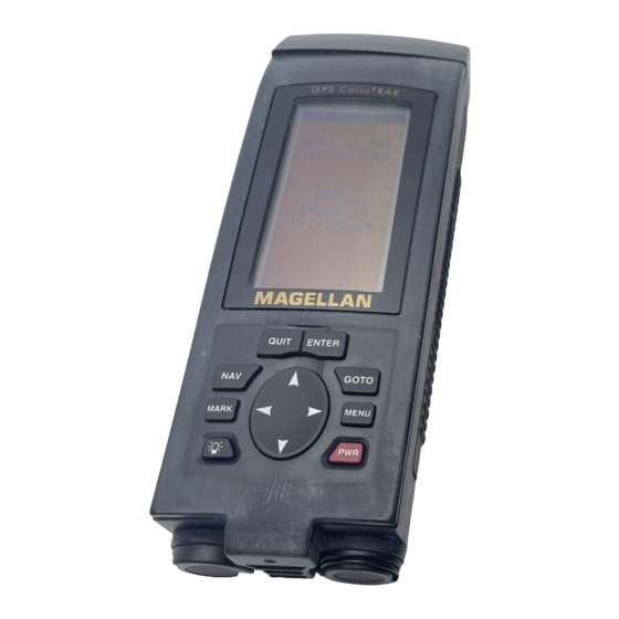
Page 13: Gps Colortrak Receiver
GPS ColorTRAK Receiver Detachable Quadrifilar Antenna Color Display ENTER key GOTO key MENU key QUIT key POWER key NAV key ARROW PAD MARK key LIGHT key Water Seal Battery Caps Magellan GPS ColorTRAK... -
Page 14: Using The Keypad
GOTO - Allows selection of a destination for a single leg route GOTO from a list of waypoints. This key also accesses the Man Over Board function. MARK - Creates waypoints or stores the current position. MARK Magellan GPS ColorTRAK... -
Page 15: Installing The Batteries
Installing the Batteries The GPS ColorTRAK uses four AA alkaline batteries that are installed from the bottom of the receiver. Use the rings to unscrew the water seal battery caps. Insert the batteries into the battery tubes, with the positive end first, two batteries in each side, and screw the battery caps until securely closed. -
Page 16: Using Your Gps Colortrak
Proper Handling - Signal Reception Because the GPS ColorTRAK receives information it needs from satellites orbiting the earth, the antenna needs to be raised with a relatively unobstructed view of the sky. -
Page 17: Holding The Receiver
Holding the Receiver GPS ColorTRAK is designed to fit comfortably in your hand. Hold the receiver in the palm of your hand with the antenna pointing towards the sky. First Time Use - Initializing the Receiver You do not need to initialize your receiver each time you use it unless the receiver’s memory has been cleared or if it has been... -
Page 18: Input Location Information
00000FT 09:23AM toggle between AM and PM. Press ENTER. The GPS ColorTRAK will not automatically change due to daylight savings. You will have to reset the time using SETUP as explained in the Customizing section The cursor moves to the date field. Use the ARROWs to input the date and press ENTER. -
Page 19: Selecting Primary Usage
Land Marine Speed Bearing Distance Heading Velocity Made Good Course To Steer Estimated Time of Arrival Time To Go Cross Track Error Recorded Position Landmark Waypoint Units of Measure Miles/MPH or NM/KNOTS KM/KPH Magellan GPS ColorTRAK... -
Page 20: Getting A Fixed Position
At this point, you should go outside in an area where you can get a clear view of the sky. The GPS ColorTRAK will begin receiving data from the satellites in view 0 0 1 1 1 2... -
Page 21: Creating A Goto
027 ˚ 50.2 You will be returned to the POSITION screen with the information on the navigational requirements. Use the NAV key to view the other Navigation screens. Magellan GPS ColorTRAK... -
Page 22: Basic Operation
The nine NAV (navigation) screens (STATUS, POSITION, NAV 1, COM- PASS, NAV 2, PLOT, ROAD, SPEED and TIME ) provide you with neces- sary information you will need to use the GPS ColorTRAK as a navigational tool. NAV screens can be viewed by pressing NAV from any screen. You can scroll through the NAV screens by repeatedly pressing NAV or the UP/DOWN ARROWs from any NAV screen. -
Page 23: Using The Status Screen
Using the Status Screen The Status screen will be the first screen displayed, after the Magellan screen, once the unit is turned on. This screen gives you the general well-being of your GPS ColorTRAK by showing you satellite status and signal strengths, battery life and temperature. -
Page 24: Selecting Temp Units And Calibration In Your Status Screen
FAHRENHEIT or CELSIUS. Use the UP/DOWN ARROWs to highlight your choice and press ENTER. Setting Temperature Calibration. The GPS ColorTRAK comes with a factory default setting that can be changed to accommodate the environment that you are in. This enables you to calibrate the temperature creating an offset from the factory setting. -
Page 25: Using The Position Screen
Automatic Averaging in the POSITION Screen Automatic averaging gives you greater position accuracy. When navigating, your GPS ColorTRAK takes position fixes, however, when you are station- ary, at zero speed, the receiver begins averaging mode. Once you begin moving, position averaging ends and the receiver begins displaying instanta- neous position fixes while you navigate. -
Page 26: Using The Nav 1 Screen
Ideally, when you are navigating, the Position Icon and the Destination Icon should line up, one above the other. Magellan GPS ColorTRAK... -
Page 27: Customizing The Nav 1 Screen
ENTER. You will return to VMG 7.2 the NAV 1 screen, still in the customize mode. 028° 01:09P You can continue to customize the display or 02H24M press QUIT to exit. L26° 01:09P 36°C BLANK Magellan GPS ColorTRAK... -
Page 28: Using The Compass Screen
The NorthFinder ™ feature displays the position of the sun and moon icons, when above the horizon, which allows you to determine the direction of north and your destination while standing still. The destination icon shows the general direction in which you should be travelling. Magellan GPS ColorTRAK... -
Page 29: Customizing The Compass Screen
DST, SOG, COG, VMG, CTS, TMP and Blank. To customize your COMPASS screen, press MENU while viewing the COMPASS screen. Highlight CUSTOMIZE and press ENTER. Use the UP/DOWN ARROWs to select the field you want to change and press ENTER. Magellan GPS ColorTRAK... -
Page 30: Using The Nav 2 Screen
UP/DOWN ARROWs to highlight your 028° choice and press ENTER. You will return to 01:09P 02H24M the NAV 2 screen, still in the customize L26° mode. You can continue to customize the display or press QUIT to exit. 01:09P 36°C BLANK Magellan GPS ColorTRAK... -
Page 31: Using The Plot Screen
RIGHT/LEFT ARROWs. An additional feature of the PLOT screen is PAN-N-SCAN. PAN-N-SCAN allows you to use the ARROWs to scroll through the PLOT screen enabling you to create waypoints and routes graphically. Magellan GPS ColorTRAK... -
Page 32: Selecting Pan-N-Scan
MENU. Highlight WPT INFO and press ENTER. The waypoint information screen will appear in place of the PAN-N-SCAN screen. Press QUIT to return to PAN-N-SCAN with the waypoint name at the top of the screen. Default setting is ON. Magellan GPS ColorTRAK... -
Page 33: Setting Track History
TRACK UP (direction you are moving is at the top of the screen), COURSE UP (the destination of the current leg is at the top of the screen) and NORTH UP (North is at the top of the screen). Magellan GPS ColorTRAK... - Page 34 MENU. Highlight PLOT SETUP and press 1 MINUTE ENTER. Use the UP/DOWN ARROWs to 2 MINUTES select COURSE PROJECTION and press 5 MINUTES 10 MINUTES ENTER. A pop-up menu appears allowing you to select OFF or a time. Magellan GPS ColorTRAK...
-
Page 35: Setting Hide Data/Show Data
If you are off course, such that the destination icon is off the screen, an arrow icon will appear to point you in the direction to get back on course. Magellan GPS ColorTRAK... -
Page 36: Setting Hide Wpts/Show Wpts
VMG 7.2 UP/DOWN ARROWs to highlight your 028°m 36°C choice and press ENTER. You will return to BLANK the ROAD screen, still in the customize mode. You can continue to customize the display or press QUIT to exit. Magellan GPS ColorTRAK... -
Page 37: Using The Speed Screen
You may want to reset the Odometer field to zero. While viewing the SPEED screen, press MENU, highlight ODOM RESET to zero and press ENTER. WARNING A pop-up window will appear. Select YES or RESET NO and press ENTER. ODOMETER TO 000? Magellan GPS ColorTRAK... -
Page 38: Resetting The Trip Odometer
03:54:21 and elapsed time in regards to the route you are navigating in. The first data field can be 01:09:24 customized to correct the current time and to OF ARRIVAL select the time format. 04:34:20 ELAPSED 02:24:56 Magellan GPS ColorTRAK... -
Page 39: Selecting Time Format
This is the fastest way to save your position. To save a waypoint with a receiver-created name, press MARK, MARK. The waypoint will be saved with a receiver-generated name beginning with WPT001, WPT002 and so on. Magellan GPS ColorTRAK... -
Page 40: Saving Your Position Fix With A User-Created Name
A waypoint is a recorded position that can be used in a route or a GOTO. You can save up to 500 waypoints in your GPS ColorTRAK and refer back to them at any time, as long as the waypoints have been saved. -
Page 41: Creating A Goto
0 0 5 4 2 TRIP 0 5 4 This completes the basic operation of the GPS ColorTRAK. From the information provided, you can now navigate from place to place quickly and easily. The following chapters provide you with additional information on using your GPS ColorTRAK that build upon what you have learned. -
Page 42: Working With Waypoints
Use the ARROWs to highlight the data field 900FT you wish to change and press ENTER. Again, 11:23:35PM 12JUN97 use the ARROWs to make your changes. NO CAMP Press ENTER to exit the edit mode for that FIRES SAVE EDITS data field. DELETE MSG Magellan GPS ColorTRAK... -
Page 43: Creating/Editing/Deleting A Message In A Waypoint
DOWN ARROW to highlight CLEAR MSG and press ENTER. Saving Changes to the Selected Waypoint To save your edits, follow the instructions on EDIT WPT selecting a waypoint. Highlight SAVE EDITS CAMP and press ENTER. 34˚06.56N 117˚49.60W 900 FT 11:23:35PM 12JUN97 CREATE MSG SAVE EDITS Magellan GPS ColorTRAK... -
Page 44: Projecting A Waypoint
You can also input information into the coordinate fields. Once you have the necessary information in the data fields and the receiver has projected the position, you can save the position by pressing MARK. Magellan GPS ColorTRAK... -
Page 45: Sorting A Waypoint
ENTER. Highlight the waypoint you wish to delete and press ENTER. Press MENU, highlight DELETE WPT and press ENTER. A pop-up window will appear. Use the UP/ DELETE DELETE DOWN ARROWs to select YES or NO and WPT023? press ENTER. Magellan GPS ColorTRAK... -
Page 46: Working With Routes
GOTO route. While in the GOTO screen, press MENU, highlight CLEAR GOTO and press ENTER. Your GOTO will be deleted. If there are no active GOTOs, then Clear GOTO will not be displayed in the MENU. Magellan GPS ColorTRAK... -
Page 47: Creating A Man Over Board Route
01 to 31. For ROUTES SETUP example, yout first backtrack will read SUN/MOON B01P01. The backtrack waypoints will be CONTRAST ALARM/MSG listed in the menu just as other waypoints. BACKTRACK routes can be deleted just as other routes. Magellan GPS ColorTRAK... -
Page 48: Creating A Multi-Leg Route
To end the creation process, use the UP/DOWN SAVE ROUTE ARROWs to highlight SAVE ROUTE and press ENTER. ˚ Press MENU, highlight SAVE ROUTE and MENU INSERT press ENTER. SAVE ROUTE WAYPOINTS ROUTES SETUP SUN/MOON FISH/HUNT CONTRAST ALARM/MSG Magellan GPS ColorTRAK... -
Page 49: Viewing/Editing A Route
While viewing the route you wish to change a waypoint in, use the UP/ DOWN ARROWs to highlight the waypoint that you want to change and press ENTER. Magellan GPS ColorTRAK... -
Page 50: Adding A Waypoint At The End Of A Route
While viewing the route you wish to delete a VIEW/EDIT waypoint from, use the UP/DOWN HOME CAMP ARROWs to highlight the waypoint you want to delete and press MENU. Highlight DELETE and press ENTER. SAVE ROUTE ˚ Magellan GPS ColorTRAK... -
Page 51: Saving A Route
While navigating in your route from home to campsite, you may decide you want to deactivate (turn off ) the route and return to it later. Press MENU and highlight ROUTES. Highlight the route that you wish to deactivate. Press MENU, highlight DEACTIVATE and press ENTER. Magellan GPS ColorTRAK... -
Page 52: Reversing A Route
After your last trip using your home to campsite route, you decide you no longer want to visit those sites. You can delete the route from your receiver. Press MENU, highlight ROUTES and press ENTER. Highlight the route that you wish to delete, press MENU, highlight DELETE and press ENTER. Magellan GPS ColorTRAK... -
Page 53: Auxiliary Functions
EXCELLENT FROM 06:15AM data screen and the Fish/Hunt data screens. 07:45 AM FROM 10:24PM 11:58PM You can change the AT and ON fields just as GOOD FROM 04:12PM you did previously, if desired. 07:40PM FROM 06:37AM 10:05AM Magellan GPS ColorTRAK... -
Page 54: Selecting The Simulate Mode
Highlight AUTO to turn the Simulate on and set a simulated route. If USER is selected, you will be asked to input USER COG and press ENTER, then input SOG 000˚ and press ENTER to display a simulate activated window. Default setting is OFF. Magellan GPS ColorTRAK... -
Page 55: Selecting Contrast
Selecting Alarm/Message Accessing the Alarm/Message Screen While navigating, you may decide to set an alarmin your GPS ColorTRAK. The GPS ColorTRAK has four types of alarms: Anchor alarm, which will notify you when your anchored boat has drifted; Arrival alarm, which will notify you when you are within the arrival circle of your destination ;... -
Page 56: Selecting Anchor Alarm
The pop- up window will display the arrival circle distance as well as any message you have inputted for the waypoint. The alarm will sound until you turn it off. The default is OFF. Magellan GPS ColorTRAK... -
Page 57: Selecting Xte Alarm
ENTER. A pop-up screen will appear with 250FT 500FT your choices for alarm settings of OFF, 100, 0.2 MI 0.5 MI 250, 500 feet, 0.2, 0.5 and 1.0 miles. High- 1.0 MI light your selection and press ENTER. Magellan GPS ColorTRAK... -
Page 58: Viewing The Alarm/Msg Menu
Viewing the Alarm/MSG Menu While viewing the Alarm/MSG screen, press MENU MENU. A menu will display a screen option DEFAULTS to DEFAULTS and CLEAR MSG. CLEAR MSG WAYPOINTS ROUTES SETUP SUN/MOON CONTRAST ALARM/MSG Magellan GPS ColorTRAK... -
Page 59: Selecting Alarm Defaults
The message buffer may become cluttered with information. You can use the CLR MSG to delete the messages. While viewing the Alarm/MSG menu, CLR MSG CLEAR highlight CLR MSG and press ENTER. A MESSAGES? pop-up window will be displayed, select YES or NO and press ENTER. Magellan GPS ColorTRAK... - Page 60 Magellan GPS ColorTRAK...
-
Page 61: Customizing (Setup)
ENTER. Follow the steps requested to ELEV MODE TIME FORMAT initialize, as done when the receiver was NAV UNITS TEMP UNITS NORTH REF initialized the first time (see Getting Started). LIGHT TIMER BEEPER PERSONALIZE CLEAR MEMORY NMEA BAUD RATE SIMULATE Magellan GPS ColorTRAK... -
Page 62: Disabling Nav Screens
ENTER. If a format is required for the coordinate LAT/LON system you have chosen, a pop-up menu will DEG/MIN.MM DEG/MIN.MMM be displayed. Highlight your selection and DEG/MIN/SEC press ENTER. Magellan GPS ColorTRAK... -
Page 63: Selecting Map Datum
3D (3-Dimensional). You may find 2D useful if you know the elevation of your position and the elevation will not change. For example, if you are at sea level, you could use 2D because you know that your elevation is zero. Magellan GPS ColorTRAK... -
Page 64: Selecting Time Format
If UTC is selected, the receiver will return to Setup. If LOCAL24HR or LOCAL AM/PM are selected, a pop-up menu will be displayed prompt- ing you to input the correct time. Use the ARROWs and press EN- TER. Magellan GPS ColorTRAK... -
Page 65: Selecting Nav Units
Default setting is NM/KNOTS for marine use. Selecting North Reference The GPS ColorTRAK uses magnetic north as a default reference for all navigation computations. You can change this to true north (good, if you are using a map) or back to magnetic north (default, good to use if you are using a compass) under SETUP. -
Page 66: Selecting Light Timer
Press MENU, from any screen, highlight BEEPER SETUP and press ENTER. Highlight BEEPER and press ENTER. A pop-up menu KEYS ONLY ALARM ONLY will be displayed, highlight your choice and KEYS /ALARM press ENTER. Default setting is ALARM ONLY. Magellan GPS ColorTRAK... -
Page 67: Selecting Personalize
A pop-up menu will be displayed, giving CLEAR MENU options for clearing. Highlight your choice TRACK HIST WPT/ROUTES and press ENTER. BACK WPTS ROUTES RESET DFALT If you clear all memory, the receiver will clear everything and power itself off. Magellan GPS ColorTRAK... -
Page 68: Selecting Nmea
Selecting Baud Rate Connection to external devices requires that the baud rate of the data being sent or received by the GPS ColorTRAK be matched to the baud rate of the external device. Your choices are 1200, 4800, 9600 and 19200 baud. -
Page 69: Troubleshooting
Availability (SA) can cause the elevation values to fluctuate. Battery life seems shorter than it should be: 1. Make sure that you are using four AA alkaline batteries. Magellan System recommends Eveready Energizers ™ for use in the GPS ColorTRAK. -
Page 70: Commonly Asked Questions
Can I use NiCad batteries in my GPS ColorTRAK? Yes. However, the battery life of your GPS ColorTRAK will be dimin- ished as well as the possibility of an incorrect reading on the battery life gauge with the use of NiCad batteries. -
Page 71: Contacting Magellan
Representatives are available Monday through Friday from 7 AM to 5 PM, PST. Faxes can be sent to Customer Service at (909) 394-7070 . If necessary, you can also return your unit to Magellan for repair (Please call for assistance first). If possible, please notify us before shipping the unit by Parcel Post or UPS, and include a description of the problem, your name, address and a copy of your sales receipt. -
Page 72: Nmea Data Messages
Data status, cross track error, direction to steer, origin, destination land- mark, landmark location, bearing to destination, and velocity toward the destination. Time, latitude, longitude, speed, heading, and date. Track (magnetic and true) and groundspeed (knots and KPH). Magellan GPS ColorTRAK... - Page 73 2-3 Lat, N or S of waypoint 4-5 Long, E or W of waypoint 6-7 Bearing, True 8-9 Bearing, Magnetic 10-11Distance, naut. miles Waypoint identifier Geographic Position — Latitude/Longitude GLL,1111.11,a,yyyyy.yy,a,hhmmss.ss,A*hh Latitude, N/S Longitude, E/W UTC of position Status A = Data valid Magellan GPS ColorTRAK...
- Page 74 A = arrival circle entered Status: A = perpendicular passed at waypoint Bearing origin to destination, M/T Destination waypoint ID 11-12 Bearing, present position to destination, Magnetic or True 13-14 Heading to steer to destination waypoint, Magnetic or True Magellan GPS ColorTRAK...
-
Page 75: Gga Global Positioning System Fix Data
SC104 Type 1 or 9 update, null field when DGPS is not used Differential reference station ID, 0000-1023 Geographic Position — Latitude/Longitude GLL,1111.11,a,yyyyy.yy,a,hhmmss.ss,A*hh Latitude, N/S Longitude, E/W UTC of position Status A = Data valid V = Data not valid Magellan GPS ColorTRAK... -
Page 76: Gsa Gps Dop And Active Satellites
(message number), minimum value 1. 2) A variable number of “PRN-Elevation-Azimuth-SNR” sets are allowed up to a maximum of four sets per message. Null fields are not required for unused sets when less than four sets are transmitted. Magellan GPS ColorTRAK... - Page 77 Magnetic variation, sense (E or W) CHECKSUM (Mandatory in this sentence) The formats listed are NMEA formats and Magellan receivers may not output all of the information listed for a particular format. A complete copy of the NMEA specifications can be obtained from:...
-
Page 78: Available Datums
Ordinance Survey of GB, Vietnam) 1936 TIMBA Timbalai GUAM Guam TOKYO Tokyo GUNSG G. Segara USER DEFINED GUNSR VOIRO HAWAI Hawaii WGS72 World Geodetic System HERAT Herat North 1972 HJORS Hjorsey 1955 YACAR Yacare HUTZU Hu-tzu-shan ZANDE Zanderij Magellan GPS ColorTRAK... -
Page 79: Specifications
Temp. Range: Operating 14˚F to 140˚F to (-10˚C to 60˚C) Storage -40˚F to 167˚F (-40˚C to 75˚C) Power: Source 4 AA alkaline batteries or 9-35 VDC with optional power cable Battery Life Up to 30 hours continuous operation Magellan GPS ColorTRAK... -
Page 80: Coordinate Systems
Positions are locations that are described in a unique way so that one loca- tion cannot be confused with another. This is done by using a coordinate system to describe locations. Your Magellan receiver has the ability to use any one of seven different coordinates systems; LAT/LON (latitude and longitude), UTM (Universal Transverse Mercator), OSGB, Irish Grid, Finnish Grid, Swedish Grid, or Swiss Grid. - Page 81 Great Britain. They must be used with the GRB36 datum, which also describes Great Britain. This coordinate system cannot be used in any other part of the world. The GPS ColorTRAK automati- cally selects the GRB36 datum when the OSGB coordinate system is se- lected in Setup.
-
Page 82: What Is Gps
Since it contains general information, an almanac can be collected from any satellite. A receiver with a current almanac in its memory knows to look for satellites, given its last position and the time of day. Magellan GPS ColorTRAK... -
Page 83: Accuracy
The differential beacon receiver receives and demodulates the signal, then relays it to the user’s differential-ready GPS receiver. The user’s GPS receiver applies the corrections to the positioning information it collects to compute Magellan GPS ColorTRAK... -
Page 84: More Information On Gps
You must also be within range of a differential radio beacon. More Information on GPS For information relating to the operation of your Magellan GPS receiver, call Magellan at (800) 707-9971 and ask for Technical Support. General information on the Global Positioning System and satellite status is available from the Civil GPS Information Center (GPSIC) in Virginia. -
Page 85: Accessories
Accessories Accessories for your GPS ColorTRAK are available from your Magellan dealer or you can order directly from Magellan using the order card supplied with your receiver or call Magellan at (800) 669-4477 (press 3 twice to place an order). -
Page 86: Antenna Removal
Antenna Removal Antenna Removal. The GPS ColorTRAK has a quadrifilar antenna that can be removed. The antenna may be removed in order to connect an external antenna. To remove the antenna, hold the receiver in one hand and rotate the antenna to the stop at the 1 o’clock position (as shown below). - Page 87 Map makers may use a different model to chart their maps, so position coordinates will differ from one datum to another. The datum for the map you are using can be found in the legend of the map. Magellan GPS ColorTRAK...
- Page 88 The angular distance east or west of the prime meridian (Greenwich Meridian) as measured by lines perpendicular to the parallels and converging at the poles from 0˚to 180˚. Magnetic North The direction relative to a magnetic compass. Magellan GPS ColorTRAK...
- Page 89 Velocity Made Good. The component of the velocity that is in the direction of the destination. Waypoint WPT. A location saved in the receiver’s memory which is obtained by entering data, editing data, calculating data or saving a current position. Used to create routes. Magellan GPS ColorTRAK...
- Page 90 Cross Track Error. The perpendicular distance between the present position and the courseline. Given as a distance, right or left, of course when facing the destination. Magellan GPS ColorTRAK...
- Page 91 Magellan GPS ColorTRAK...
- Page 92 Keys 4-5 Cross Track Error (XTE) 10, 18, 21, 26, 48 Course over Ground (COG) Landmark (LMK) 10 17, 19, 26, 27, 28 LAT/LON 16, 53; Course Projection 25 troubleshooting 60 Customer Service 62 Light Timer 57 Magellan GPS ColorTRAK...
- Page 93 Projecting a Waypoint 35 Power On 8, 13 Waypoint creating 31; editing 33; hide/show 27; naming 30, 31; saving 11, 30, 34 Reception 7 Routes 37; activating/deactivat ing a route 42; adding a XTE see Cross Track Error Magellan GPS ColorTRAK...
- Page 95 S Y S T E M S C O R P O R AT I O N 960 Overland Court, San Dimas, CA 91773 (909) 394-5000 22-10303-001...