Sign In
Upload
Manuals
Brands
Lorenz Manuals
GPS
Compact 7 Sun Color
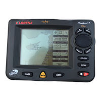
Lorenz Compact 7 Sun Color Chartplotter Manuals
Manuals and User Guides for Lorenz Compact 7 Sun Color Chartplotter. We have
1
Lorenz Compact 7 Sun Color Chartplotter manual available for free PDF download: User Manual
Lorenz Compact 7 Sun Color User Manual (112 pages)
Brand:
Lorenz
| Category:
GPS
| Size: 3.63 MB
Table of Contents
Table of Contents
3
1 Introduction
9
Conventions
9
Features
10
Specifications
10
Main Characteristics
10
Phisical Characteristics
12
Basics
13
2 Before You Begin
15
The Keyboard
15
Turning the Chartplotter on and off
16
Turning on
16
Turning off
17
Changing Keypad Backlight and Contrast
17
Selecting the Language
17
External Connections
18
GPS Connection for CHARTPLOTTER with EXTERNAL GPS RECEIVER
18
Autopilot Connection
20
External NMEA Connection
20
C-COM GSM Plus Connection
21
Beacon Receiver Connection
22
For Chartplotter with External GPS Receiver
22
For Chartplotter with Internal GPS Receiver
22
Additional C-Cards
22
Inserting C-CARD
23
Removing C-CARD
23
Menu Options
24
Data Entry
24
3 For the New User
25
Screen Display Configuration
25
Charts and Text Area
25
Depth Graph
27
GPS Data Page
27
Navigation Data Page
28
Graphic Data (Rolling Road) Page
28
Basic Settings
29
Course Vector
29
Screen Amplifier
29
Advanced Functions
29
User Points
29
Depth Window
29
Units Selection
30
Nav Aids Presentation
30
Input/Output Menu
30
Port 1/Port 2/Port 3 Input
30
Port 1/Port 2/Port 3 Output
31
Port 1/Port 2/Port 3 NMEA Output Messages Selection
31
GPS Setup Menu
31
Internal GPS for CHARTPLOTTER with INT . GPS RECEIVER
31
Restart GPS
31
Differential Correction Source
32
Navigation Speed
32
Send & Receive Marks/Routes
32
C-Link
32
Cable Wiring Page
32
C-Voice Menu
32
Navigation
32
Echosounder
33
Output Port
33
A-B-C-D Function
33
Inserting the A-B-C-D Points
33
Deleting the A-B-C-D Points
34
Navigating on the A-B-C-D Points
34
Navigating to a Single Destination
34
Distance and Bearing to Target
34
Time to Go
34
Deleting Target
35
C-Map Nt Max Information
35
Map Menu
36
Perspective View
36
Palette for COLOR CHART PLOTTER
36
Map Orientation
37
Zoom Type
37
Fonts & Symbols
37
Dynamic Nav-Aids
38
Mixing Levels
38
Safety Status Bar
38
Currents Prediction
39
Other Map Configurations
40
Getting Automatic Info
43
Info on Objects with Pictures
44
Change Picture Size
44
Info Tree and Expanded Info Page
44
Info Function
45
Getting Port Info
45
Getting Tide Info
45
Find Function
47
Finding Nearest Services
47
Find Port
47
Searching by Name
47
Searching Port into Selected Range
47
Finding Tide Stations
48
Finding Wrecks
48
Finding Obstructions
48
Man Overboard (Mob)
48
Inserting MOB
48
Deleting MOB
49
4 For the Experienced User
51
More about Creating and Using Routes
51
Waypoint
51
Adding Waypoint
51
Creating a Route
52
Deleting Waypoint
52
Deleting Route
53
Distance and Bearing to Target
53
Deleting Target
54
Moving Waypoint
54
Time to Go
54
Inserting Waypoint
55
Editing Waypoint
56
Finding Info about Waypoints: User Points List Page
57
Finding User Points
57
Deleting All Stored User Points
58
Deleting All User Points with the same Symbol
58
Deleting All User Points with the same Type
58
Deleting Selected User Point
58
Send/Receive User Points
58
Routes
58
Selecting Route
58
Deleting Route
59
Finding Information about a Route: Route Report
59
Reversing Route
59
Changing Speed & Fuel Values
60
Deleting Route
60
Reversing Route
60
Route Name
60
Selecting Route
60
Send/Receive Route
60
Using Marks & Events
61
Marks
61
Adding Mark
61
Deleting Mark
61
Goto
61
Moving Mark
61
Editing Mark
62
Add to Route
63
Finding Information about Marks: User Points List Page
63
Events
63
Adding Event
64
Deleting Event
64
Editing Event
64
Goto
64
Add to Route
65
Finding Information about Events: User Points List Page
65
More about A-B-C-D Function
65
Inserting the A-B-C-D Points
65
Deleting the A-B-C-D Points
66
Deleting the A-B-C-D Segment
66
Moving the A-B-C-D Points
66
Inserting the A-B-C-D Points
66
Navigating on the A-B-C-D Points
66
Using the Track Functions
66
Selecting Active Track
67
Enabling Track Storing
67
Displaying Track
67
Selecting Track Line Pattern
67
Deleting Track
67
Deleting Selected Track
67
Selecting Track Memorizing Type
68
Selecting Distance
68
Selecting Time
68
User C-Card Menu
68
Saving File
69
Loading File
70
Deleting File
70
Formatting Usr C-CARD
70
Changing Userc-CARD
70
C-Link
71
How C-Link System Works
71
C-Link Navigation Data Transfer
71
Operations
72
Introductive Elements
72
C-Link Serial Connection
73
Master Chart Plotter
73
Operating Mode
73
Slave Chart Plotter
73
Stop Current Navigation
73
C-Link Navigation Data: Acquisition and Display
74
Inhibit Navigation Operation
74
Inhibit Route Following
74
MOB Handling
74
Notes
74
Graphical Representation on Map Display
75
Route Data Report
75
Quick Info
76
Quick Info on Single Destination
76
Route Navigation: Quick Info on the Destination
76
5 Advanced Settings
77
Setup
77
Time Reference
77
Time Format
77
Date Format
78
Wind Speed
78
Beeper
78
Extern Waypoint
78
Backlight Timeout
78
Fix
78
Fix Correction
79
Compute Correction
79
Correction Offset
79
Position Filter
79
Speed Filter
79
Filter Dump
79
Dead Reckoning
80
Static Navigation
80
Navigate
80
Coordinate System
80
Fix Datum
80
Map Datum
81
Map Orientation and Resolution
81
Rolling Road Scale
81
Reset Total and Partial Trip
81
Compass
81
Bearings
82
Variation
82
Calibration
82
Alarms
82
Arrival Alarm
82
XTE Alarm
83
Anchor Alarm
83
Depth Alarm
83
Grounding Alarm
83
Grounding Alarm Range
84
Grounding Alarm Report
84
Simulation Menu
84
Simulation Mode
84
Speed
84
Heading
84
Date and Time
85
Cursor Control
85
C-Staff
85
C-Meteo
85
Fish Finder Menu
86
6 For the Technician
87
Dimensions
87
Installation and Removing
88
External Wiring
90
Typical Connections
91
Troubleshooting
94
Problems and Solutions
94
Help
94
If You Need Assistance
94
World Background Charts
95
Worldwide Background Update
95
System Test
95
RAM Menu
96
DIM Menu
96
Cartridges
96
Serial Ports
97
Modem Test
97
A Terms
99
B Smart DGPS WAAS Receiver
105
Technical Specifications
105
Pysical Characteristics
105
Electrical Characteristics
105
GPS Performance
105
Environmental Characteristics
106
Wiring
106
Software Interface
106
Mechanical Characteristics & Mounting
107
Installing
107
Dimensions
108
Analytical Index
109
Advertisement
Advertisement
Related Products
Lorenz Compact 7 Plus
Lorenz Excalibur 7 Speed
Lorenz 7S509
Lorenz 7S532
Lorenz 7S559
Lorenz 7S579
Lorenz 7S604
Lorenz 7S629
Lorenz 7S699
Lorenz 7S729
Lorenz Categories
Metal Detector
GPS
Watch
Amplifier
Accessories
More Lorenz Manuals
Login
Sign In
OR
Sign in with Facebook
Sign in with Google
Upload manual
Upload from disk
Upload from URL