Sign In
Upload
Manuals
Brands
Leica Geosystems Manuals
Scanner
T-Scan Collect
Leica Geosystems T-Scan Collect Manuals
Manuals and User Guides for Leica Geosystems T-Scan Collect. We have
1
Leica Geosystems T-Scan Collect manual available for free PDF download: Reference Manual
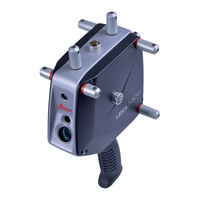
Leica Geosystems T-Scan Collect Reference Manual (139 pages)
Brand:
Leica Geosystems
| Category:
Scanner
| Size: 5 MB
Table of Contents
1 Introduction
2
Purchase
2
Trademarks
2
Validity of this Manual
2
Feedback
2
Contact
2
Table of Contents
3
2 Contents
3
3 Revisions
7
4 Scan Collect - Software - Introduction
8
Installation and Program Start
8
Licensing
8
5 Working with Viewers
9
Viewer
9
Status Indicators
13
Additional Coordinate Axes
14
Data Explorer
14
6 Customizing the User Interface
21
7 Measurement
25
Selection of Measurement Mode
25
Measurement Settings
25
General
26
Line Scanner
26
Surface Mode
28
Point Mode
32
Static Polyline Mode
33
Dynamic Polyline Mode
35
Starting a Measurement
35
Surface Mode
35
Point Mode
36
Static Polyline Mode
37
Dynamic Polyline Mode
38
Stopping a Measurement
39
8 Interactive Tools
40
Selection Mode
41
Interactive Clipping
41
Check Accuracy
41
Cross Sections
44
Create Reference Points
45
Fill Holes (Triangle Mesh)
46
Create Bridges (Triangle Mesh)
47
Smoothing (Triangle Mesh)
48
Decimate Mesh (Triangle Mesh)
49
Sharpen Edges (Triangle Mesh)
50
Alignment Calibration
50
9 Calibration
51
Calibrate Measurement Range
51
Preparation
51
Procedure
51
Alignment Calibration
54
Requirements for an Alignment Sphere
54
Measurement Strategy
54
Step-By-Step Guide
57
10 Working with Files
60
Create New Project
60
Open Existing Project
60
Save Project
60
Save Project under New Name
60
Import Data
60
Using the File Menu
61
Using the Data Explorer
61
Using Drag and Drop
61
Export Data
61
Using the Data Explorer
62
11 Processing of Data Sets
63
Transform Data
63
Transform
63
Transform to Nominal Points
64
Planes Alignment
70
3-2-1 Alignment
73
Scale
77
Mirror
77
Optimize Data
77
Smoothing
77
Decimating
78
Matching
78
Global Matching
78
Tolerance Based Matching
83
Optimize Triangle Meshes
86
Remove Unassociated Areas
86
Remove Outliers
87
Noise Reduction
87
Curvature Based Decimation
88
Smoothing
88
Interactive Tools
88
12 Post-Processing
89
13 Calculation of Feature Lines
93
Calculation of Feature Lines
94
Calculation of V-Lines
96
Interactive Generation of Polylines
97
Processing of Polylines and Triangle Meshes
98
Viewer Control
100
14 Service
101
15 Tracking System
102
Initialize
102
Disconnect/Connect
102
Environmental Parameters
102
Laser Control
103
Reflectors
103
Information
103
Go Birdbath
104
Go Zero Position
104
Move Station
104
Measuring the Pass Points
105
Selection of Pass Points
106
Moving the Station
107
Measuring the Pass Points
107
Transformation Results
108
Invoking Move Station Again
109
Release Motors
110
16 Digitize
111
Start
111
Stop
111
Information
111
17 Settings
113
Cross Sections
113
Matching
114
Viewer
116
General Settings
116
Lines
116
Surfaces
117
Other Settings
118
Dynamic Camera
119
Coordinate Axes
120
Accuracy Check
120
Measuring Mode
120
Measurement
121
Acoustic Feedback
121
Materials
122
Adjust Size Automatically
123
Display Scanner
123
Display T-Probe
124
Display T-Probe Coordinates
124
Keep on Top
125
18 Extras
126
Execute Macro
126
19 Help
127
About T-Scan Collect
127
20 Appendix
129
DCOM Configuration
129
T-Scan Collect Vs. T-Scan Interface
132
21 Index
136
Advertisement
Advertisement
Related Products
Leica Geosystems T-Scan
Leica Geosystems TS15
Leica Geosystems TS11
Leica Geosystems TPS700 Series
Leica Geosystems TPS700auto
Leica Geosystems TM6100A
Leica Geosystems Zeno Tab 2
Leica Geosystems TCPS27
Leica Geosystems TS12
Leica Geosystems 3D Disto
Leica Geosystems Categories
Measuring Instruments
Laser Level
Analytical Instruments
Scanner
Receiver
More Leica Geosystems Manuals
Login
Sign In
OR
Sign in with Facebook
Sign in with Google
Upload manual
Upload from disk
Upload from URL