Sign In
Upload
Manuals
Brands
Garmin Manuals
GPS
GPSMAP 496
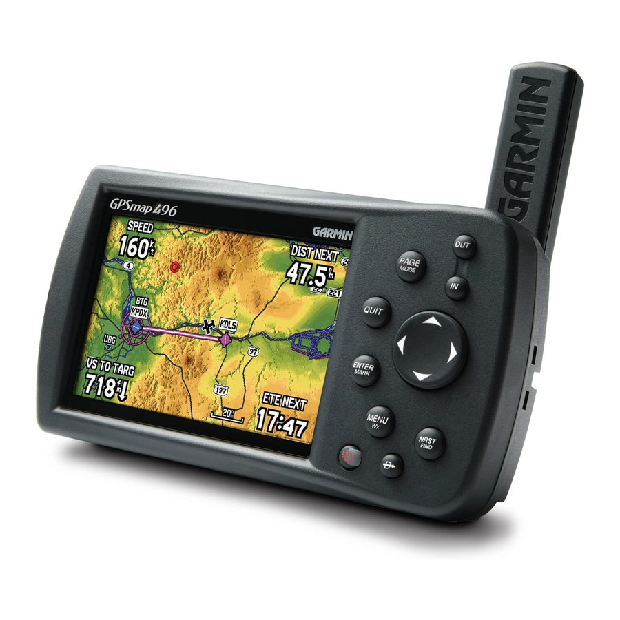
Garmin GPSMAP 496 Manuals
Manuals and User Guides for Garmin GPSMAP 496. We have
8
Garmin GPSMAP 496 manuals available for free PDF download: Owner's Manual, Features, Quick Reference Manual, Specifications, Declaration Of Conformity
Garmin GPSMAP 496 Owner's Manual (196 pages)
portable aviation receiver
Brand:
Garmin
| Category:
GPS
| Size: 4 MB
Table of Contents
About this Manual
3
Manual Conventions
3
Table of Contents
4
Warning
7
Caution
8
Getting Started
9
Unit Overview
9
Charging the GPSMAP 496
10
Information about Charge Mode
10
Turning on the GPSMAP 496
11
Adjusting the Backlight and Volume
11
Getting Satellite Signals
12
Viewing GPS Status with the GPS Tab
12
Receiver Status
13
Gps Tab Options
14
Gps Tips
14
Learning about the Keypad
15
Using the GPSMAP 496
16
Understanding Terms
16
Selecting Options and Entering Data
17
Entering Data
18
Mapsource Detailed Maps
18
Simulator Mode
19
Entering a New Location
20
Basic Operation in Aviation Mode
21
Aviation Mode Page Sequence
21
Creating a Direct to
22
Viewing Details for the Destination
23
Viewing Frequency Restrictions
24
Finding a Nearby Point
26
Aviation Nearest Categories
26
Selecting a Nearby Point as Your Destination
27
Viewing Details for a Nearby Point
27
Viewing Communication Frequencies
28
Viewing Airspace Alert Information
28
Viewing Additional Airspace Information
29
Setting Airport Criteria
30
Selecting an Approach
31
Understanding Vectors
32
Finding Points on Land
33
Marking a Waypoint
34
Creating a Flight Plan (Route)
35
Following Your Flight Plan
36
Track Your Progress on the Map Page
36
Aviation Mode
37
Map Page
37
Selecting Map Ranges
38
Map Orientation
38
Panning the Map
39
Airspace Information
40
Smart Airspace
40
Clearing Unwanted Details from the Map
41
Measuring Distance
41
Setting the Bug Indicator
42
Setting up the Map Page
42
Changing the Page Layout and Data Fields
43
Terrain Page
45
Terrain Information
45
Obstacle Information
45
Terrain and Obstacle Color Code
45
Setting up the Terrain Page and Alerts
47
Panel Page
48
Manually Setting a Course
49
Setting up the Panel Page
49
VNAV (Vertical Navigation)
50
Using the VNAV Feature
50
Active Route Page
52
Position Data Page
53
Flight Log
54
Viewing the Flight Log
54
Deleting Flight Records
54
Aircraft Information
55
Calculating the Weight & Balance
56
E6B Tab
57
XM Audio Page
59
Using Favorites
61
Basic Operation in Automotive Mode
63
Automotive Mode Page Sequence
63
Navigating in Automotive Mode
64
Finding an Item
66
Using the Find from Feature
66
Recently Found Items
67
Find Menu Options
68
Viewing the Information Page
68
Creating Routes
69
Creating Waypoints
71
Marking Your Present Location
71
Creating Waypoints from the Map
72
Creating a Waypoint by Entering Coordinates
73
Following an Automotive Route
74
Editing Your Route
75
Entering Custom Avoids
75
Creating a Detour
76
Adding and Editing Stops (Via Points)
76
Automotive Mode Pages and Features
77
Map Page
77
Highway Page
78
Using the Highway Page
78
Highway Page Options
79
Current Route Page
80
Saving the Current Route
80
Trip Computer
81
Editing and Managing Routes
82
Viewing All of Your Saved Routes
82
Using the Route Options
82
Navigating a Saved Route
83
Editing a Route
83
Editing and Managing Waypoints
86
Adding a Waypoint to a Route
88
Waypoint Options Menu
88
Averaging the Waypoint's Location
88
Projecting a Waypoint
89
Organizing Waypoints into Categories
90
Managing Points
91
User Points Tab
91
Deleting Waypoints
92
Proximity Points
93
Managing Your Tracks
95
Setting up and Saving Your Tracks
95
Navigating a Saved Track
98
Tracback Tips
98
Basic Operation in Marine Mode
99
Marine Mode Page Sequence
99
Navigating in Marine Mode
100
Man Overboard (MOB)
100
Marine Mode Pages and Features
101
Map Page
101
Compass Page
102
Using the Marine Timer
103
Dsc
104
Understanding Position Reports
105
Understanding Distress Calls
105
Receiving Dsc Calls
105
DSC Call List
106
Dsc Directory
107
Navigating to a Position Report or Distress Call
108
Setting up Dsc
108
Main Menu
109
GPS Tab
109
Weather Tab
110
XM Tab
110
Flights Tab
111
Route Tab
111
Points Tab
112
Track Tab
112
Sonar Tab
113
Aircraft Tab
113
Alarms Tab
114
Celestial Tab
117
Tide Sub Tab
118
Message Tab
121
Display Tab
122
Sound Tab
123
Setup Tab
124
Location Sub Tab
128
Selecting a Different Heading Reference
129
Advanced Nmea Output Setup
133
Using XM WX Weather
134
Viewing XM WX Weather
134
Setting XM WX Weather Options
135
Weather Explorer Tab
136
Using the Weather Tab
138
Weather Options
139
Finding Weather Information
141
Setting up and Using Sonar
143
Showing Sonar on the Map Page
143
Using the Sonar Page
144
Adjustment Options
145
Adjusting the Sonar Page
145
Resizing the Split Screen
147
Using the Pointer on the Sonar Page
147
Setting up the Sonar Page
148
Calibrating the Water Speed
149
Setting up the Sonar Display
150
Understanding Sonar
151
Understanding the Sonar Display
151
Transducer Coverage
152
Viewing the Sonar Temperature Tab
154
Reset the Temperature Graph
154
Tis (Traffic Information Service)
155
TIS Limitations
156
TIS Symbology
158
TraffiC Ground Track
159
TraffiC Warning Window
159
Map Page
160
TIS Operational Procedures
161
VHF Comm
162
Appendix
163
Specifications
163
Care Information
164
Cleaning the Unit
164
Immersing the Unit in Water
164
Optional Accessories
165
Installation Information
166
Connecting the Power/Data Cable
166
Connecting to a Gtx 330 Mode S Transponder
167
Connecting to a Garmin Vhf Comm Radio
167
Information about Usb Drivers
168
Serial Communications Port
168
Using Ximage for Customized Waypoint Symbols
169
Installing and Removing Data Cards
169
Learning about GPS
171
Common GPS Terms
171
What Is Differential GPS (DGPS)
171
Differential Field
171
What Is WAAS/EGNOS
172
LORAN TD Setup
173
LORAN TD Feature
173
Using the LORAN TD Format
173
Map Datums and Location Formats
175
What Are Map Datums
175
What Is a Location Format
175
Digital Selective Calling (DSC)
176
What Is a Maritime Mobile Service Identity (MMSI)
176
How Are Mmsi Assignments Obtained
177
How Can Garmin Help You with Dsc
177
Jeppesen Database Information
178
Database Updates
178
Messages
179
Data Field Options
182
License Agreement and Warranty
184
Software License Agreement
184
Product Registration
184
Contact Garmin
184
Limited Warranty
185
Aopa Airport Directory Notice
186
Weather Data Warranty
186
XM Satellite Radio Service Agreement
188
Fcc Compliance
188
Index
189
Advertisement
Garmin GPSMAP 496 Owner's Manual (164 pages)
Portable aviation receiver
Brand:
Garmin
| Category:
GPS
| Size: 5 MB
Table of Contents
Table of Contents
4
Introduction
5
Warnings
6
Battery Warnings
7
Important Information
7
Care Information
8
Cleaning the Unit
8
Immersing the Unit in Water
8
Getting Started
9
Unit Overview
9
Charging the GPSMAP 496
10
Turning on the GPSMAP 496
11
Getting Satellite Signals
12
Receiver Status
13
Gps Tab Options
14
Gps Tips
14
Learning about the Keypad
15
Using the GPSMAP 496
16
Selecting Options and Entering Data
17
Simulator Mode
19
Entering a New Location
20
Basic Operation in Aviation Mode
21
Aviation Mode Page Sequence
21
Creating a Direct to
22
Finding a Nearby Point
25
Setting Airport Criteria
29
Selecting an Approach
30
Understanding Vectors
31
Finding Points on Land
32
Marking a Waypoint
33
Creating a Flight Plan (Route)
34
Following Your Flight Plan
35
Aviation Mode
36
Map Page
36
Map Orientation
37
Selecting Map Ranges
37
Panning the Map
38
Airspace Information
39
Smart Airspace
39
Clearing Unwanted Details from the Map
40
Measuring Distance
40
Setting the Bug Indicator
41
Changing the Page Layout and Data Fields
42
Terrain Page
44
Panel Page
47
Manually Setting a Course
48
Active Route Page
51
Position Data Page
52
Flight Log
53
Aircraft Information
54
E6B Tab
56
Basic Operation in Automotive Mode
58
Automotive Mode Page Sequence
58
Navigating in Automotive Mode
59
Finding an Item
61
Recently Found Items
62
Find Menu Options
63
Creating Routes
64
Creating Waypoints
66
Creating a Waypoint by Entering Coordinates
68
Following an Automotive Route
69
Editing Your Route
70
Creating a Detour
71
Automotive Mode Pages and Features
72
Map Page
72
Highway Page
73
Current Route Page
75
Trip Computer
76
Editing and Managing Routes
77
Navigating a Saved Route
78
Editing a Route
78
Editing and Managing Waypoints
81
Adding a Waypoint to a Route
83
Projecting a Waypoint
84
Organizing Waypoints into Categories
85
Deleting Waypoints
87
Proximity Points
88
Managing Your Tracks
90
Navigating a Saved Track
93
Tracback Tips
93
Basic Operation in Marine Mode
94
Marine Mode Page Sequence
94
Navigating in Marine Mode
95
Marine Mode Pages and Features
96
Map Page
96
Compass Page
97
Using the Marine Timer
98
Dsc
99
Understanding Distress Calls
100
Understanding Position Reports
100
Receiving Dsc Calls
100
Dsc Directory
102
Navigating to a Position Report or Distress Call
103
Setting up Dsc
103
Main Menu
104
GPS Tab
104
Flights Tab
104
Route Tab
105
Points Tab
105
Track Tab
105
Sonar Tab
106
Aircraft Tab
106
Alarms Tab
107
Celestial Tab
110
Tide Sub Tab
111
Message Tab
114
Display Tab
115
Sound Tab
116
Setup Tab
117
Location Sub Tab
122
Advanced Nmea Output Setup
126
Setting up and Using Sonar
127
Showing Sonar on the Map Page
127
Using the Sonar Page
128
Adjustment Options
129
Resizing the Split Screen
131
Setting up the Sonar Page
132
Calibrating the Water Speed
133
Setting up the Sonar Display
134
Understanding Sonar
135
Transducer Coverage
136
Viewing the Sonar Temperature Tab
138
VHF Comm
139
Appendix
140
Specifications
140
Optional Accessories
141
Installation Information
142
Connecting to a Gtx 330 Mode S Transponder
143
Connecting to a Garmin Vhf Comm Radio
143
Using Ximage for Customized Waypoint Symbols
144
Information about Usb Drivers
144
Installing and Removing Data Cards
145
Declaration of Conformity (Doc)
146
Learning about GPS
147
LORAN TD Setup
148
Map Datums and Location Formats
150
Digital Selective Calling (DSC)
151
Jeppesen Database Information
152
Messages
153
Data Field Options
155
License Agreement and Warranty
157
Limited Warranty
158
Index
159
Garmin GPSMAP 496 Owner's Manual (48 pages)
XM Radio Smart Antenna
Brand:
Garmin
| Category:
Radio Antenna
| Size: 1 MB
Table of Contents
Terminology Used Throughout this Manual
5
Product Registration
6
Table of Contents
7
Able of
7
Getting Started
8
Unit Overview
8
Connecting the GXM 30A to a Garmin Unit
9
Subscribing to XM WX Weather and Radio
10
XM WX Weather Features
12
Displaying Weather Information
12
NEXRAD Radar
13
Satellite Mosaic
14
Lightning
15
Storm Cells
16
Hurricanes
17
Surface Winds
18
Winds Aloft
19
Surface Pressure
20
Fronts
21
Visibility
22
County Warnings
23
Water Temperature
24
Wave Period
24
Wave Direction
25
Wave Height
25
Marine Warnings
26
Buoy Reports
27
Metar
28
Airmet
29
Sigmet
30
Tfr
31
Echo Tops
32
Freezing Level
33
Forecast
33
Taf
34
XM Radio
34
Appendix
35
GXM 30A Specifications
35
Feature Broadcast Rates
36
NEXRAD Abnormalities
37
NEXRAD Limitations
37
NEXRAD Overview
37
NEXRAD Intensity
38
FCC Compliance
39
Limited Warranty
40
Software License Agreement
42
XM Satellite Radio Service Agreement
42
Weather Data Warranty
43
TFR Data
44
Index
45
Advertisement
Garmin GPSMAP 496 Features (7 pages)
Visual Land Owner's manual MP3 Player GPSMAP 296
Brand:
Garmin
| Category:
GPS
| Size: 0 MB
Table of Contents
Gpsmap196
1
Gpsmap296
1
Gpsmap496
2
Garmin Portable GPS Accessories
3
NüVI 310 Features
3
Gpsmap96 & 96C
4
Etrex
4
Skyforce SKYMAPIIIC
5
Skyforce KMD150
5
Skyforce Accessories
5
Avmap Ekp-IV
5
Lowrance AIRMAP500
6
Lowrance AIRMAP600C
6
Lowrance AIRMAP1000
6
Lowrance AIRMAP2000C
6
Avmap Geopilot & Geopilotplus
6
Garmin GPSMAP 496 Quick Reference Manual (2 pages)
Garmin GPSMAP 400: Reference Guide
Brand:
Garmin
| Category:
GPS
| Size: 0 MB
Table of Contents
Where to Creating and Using Waypoints
1
Turning the Unit on or off Using the Keypad
2
Acquiring GPS Satellite Signals
2
Creating and Using Routes
2
Adjusting the Backlight
2
Panning the Navigation Chart
2
Zooming in and out on the Map
2
Garmin GPSMAP 496 Specifications (2 pages)
Brand:
Garmin
| Category:
GPS
| Size: 2 MB
Garmin GPSMAP 496 Quick Reference Manual (2 pages)
Garmin GPSMAP 496: Quick Reference
Brand:
Garmin
| Category:
GPS
| Size: 0 MB
Garmin GPSMAP 496 Declaration Of Conformity (1 page)
Declaration of Conformity
Brand:
Garmin
| Category:
GPS
| Size: 0 MB
Advertisement
Related Products
Garmin GPSMAP 498C - Marine GPS Receiver
Garmin GPSMAP 492 - Marine GPS Receiver
Garmin GPSMAP 498
Garmin GPSMAP 495
Garmin GPSMAP 4210
Garmin GPSMAP 478 - Marine GPS Receiver
Garmin GPSMAP 430x - Marine GPS Receiver
Garmin GPSMAP 440x - Marine GPS Receiver
Garmin 400/500
Garmin GPSMAP 45000 series
Garmin Categories
GPS
Watch
Car Navigation system
Avionics Display
Marine Equipment
More Garmin Manuals
Login
Sign In
OR
Sign in with Facebook
Sign in with Google
Upload manual
Upload from disk
Upload from URL