
Esterline CMA-9000 Manuals
Manuals and User Guides for Esterline CMA-9000. We have 2 Esterline CMA-9000 manuals available for free PDF download: Operator's Manual
Esterline CMA-9000 Operator's Manual (802 pages)
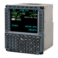
Flight Management System
Table of Contents
-
-
-
Preflight54
-
Initial Leg69
-
-
Subject Page90
-
-
By Clear Key100
-
Leg Sequencing102
-
Fly-By Waypoints102
-
-
Eta and Efa104
-
Rnp Modification122
-
Route 2 Option123
-
Nearest126
-
-
-
-
General141
-
Vfr Approaches154
-
-
-
-
Introduction175
-
-
-
General185
-
Entry Procedures186
-
Continue to Hold199
-
-
-
User Database225
-
Carp Re-Entry283
-
Exit from Carp283
-
Carp Wind Entry284
-
-
General297
-
Egi Navigation300
-
Position Update308
-
Dme Navigation312
-
Irs System Pages324
-
-
-
General329
-
Com Library 1/N402
-
Nav Library 1/N404
-
Adf Library 1/N405
-
Uhf Library 1/N407
-
Df Library 1/N411
-
-
-
-
-
Arrivals 1/X447
-
Comm Status 1/1471
-
Departures 1/X477
-
Deselect 1/1483
-
Display 1/1486
-
Ess Failure 1/1494
-
Fix Info 1/1495
-
Gps Deselect 1/1506
-
Hold 1/X515
-
Ident 1/2522
-
Radial585
-
RTE X 1/X589
-
RTE X 2/X596
-
RTE X LADDER 1/1599
-
RTE X LEGS 1/X605
-
RTE X SECTOR 1/1617
-
RTE X SQUARE 1/1621
-
Sarsat Data 1/X625
-
Setup 1/1634
-
-
Introduction695
-
Radial-To713
-
Search Pattern714
-
-
Introduction717
-
Map Mode718
-
Plan Mode719
-
Introduction726
-
Efis Displays728
-
Typical Route728
-
Parallel Entry730
-
Offset Entry731
-
Procedure Turn732
-
Map Center Step733
Advertisement

Esterline CMA-9000 Operator's Manual (561 pages)
flight management system
Table of Contents
-
Section 1
28 -
Section 2
44 -
Section 3
58-
Preflight61
-
Initial Leg75
-
Section 4
82 -
Section 5
92-
By Clear Key102
-
Fly-By Waypoints104
-
Leg Sequencing104
-
Eta and Efa106
-
Rnp Modification122
-
Route 2 Option123
-
Nearest127
-
Section 6
138-
General140
-
Vfr Approaches151
-
Procedure Turns155
-
-
Section 7
162-
Introduction164
-
-
Section 8
172-
General174
-
Entry Procedures175
-
Continue to Hold184
-
Prior to Entry185
-
-
Section 9
186 -
Section 10
195-
General197
-
Gps Navigation198
-
Position Update199
-
Dme Navigation200
-
Irs System Pages206
-
-
Section 11
207-
General209
-
Vor Library 1/N232
-
Adf Library 1/N234
-
Hf Library 1/N235
-
-
Section 12
241-
Overview243
-
-
Accuracy245
-
Integrity245
-
Continuity245
-
-
-
Accuracy246
-
Integrity246
-
Continuity246
-
-
-
Accuracy247
-
Integrity247
-
Continuity247
-
-
-
Section 13
253 -
Section 14
260-
-
Arrivals 1/X263
-
Calc/Conv 1/2266
-
Calc/Conv 2/2266
-
Comm Status 1/1269
-
Departures 1/X272
-
Deselect 1/1275
-
Display 1/1276
-
Dme Status 1/1277
-
Ess Failure 1/1278
-
Fix Info 1/1278
-
Flight Log 1/1279
-
FUEL 1/2 Page280
-
Hold 1/X284
-
Ident 1/2289
-
Ident 2/2290
-
Nav Data 1/1301
-
Pos Init/Ref 1/3309
-
Progress 1/4316
-
Progress 2/4316
-
Progress 4/4322
-
Rta Progress 3/4323
-
RTE X 1/X324
-
RTE X 2/X329
-
-
Section 15
362-
Perf Init 1/1
367 -
Crz 2/5
381-
Crz Sched 1/1381
-
-
Des 3/5
390-
Des Sched 1/1390
-
-
Appr 4/5
398-
Appr Ref 1/2398
-
Appr Ref 2/2400
-
Go Around 5/5401
-
Vnav Profile 1/2404
-
Des Forecast 1/2407
-
Des Forecast 2/2409
-
Legs 1/X410
-
Legs Eta 1/X413
-
-
Progress 1/4
415-
Hold 1/X415
-
Rta Progress 3/4416
-
-
Ident 2/2
420 -
Eng out Crz 2/5
428 -
Eng out Clb 1/5
428-
E/O Sched428
-
-
-
Section 16
430-
Introduction432
-
Radial-To450
-
Section 17
452 -
Section 18
474 -
Section 19
504-
Overview
508 -
Preflight
516 -
-
Speeds520
-
Speed Schedules520
-
Speed Limiting521
-
-
TAKEOFF REF Page523
-
CLB Page524
-
LEGS Page524
-
PROFILE Page525
-
-
Takeoff
526 -
Climb
527 -
Cruise
533-
Cruise Winds533
-
Maximum Altitude533
-
Early Descent548
-
Late Descent548
-
End-Of-Descent553
-
-
Approach
555-
Target Speed557
-
Second Route
559
-