Sign In
Upload
Manuals
Brands
ComNav Manuals
Fish Finder
M10
ComNav M10 Manuals
Manuals and User Guides for ComNav M10. We have
2
ComNav M10 manuals available for free PDF download: Installation & Operation Manual
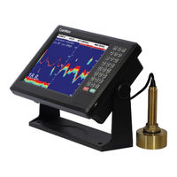
ComNav M10 Installation & Operation Manual (80 pages)
MULTI-FUNCTION CHART-PLOTTER AND AUTOMATIC IDENTIFICATION SYSTEM
Brand:
ComNav
| Category:
Plotter
| Size: 5 MB
Table of Contents
Welcome
3
Warranty Notice
3
General Notice
3
Copyright
3
Warning
3
Technical Support
5
Document History
5
About this Manual
5
Manual Format
5
Table of Contents
6
List of Figures
9
List of Tables
10
Overview
12
Safety Notes
12
Figure 1 - the M10
12
Installation
13
Tools Required
14
Power Supply
14
Environmental Considerations
14
Hazard Warning
14
Warnings and Cautions
15
Regulations and Safety
15
Use and Care
15
Getting Started with M10
16
About the M10
16
Button Function and Operation
16
Figure 2 - M10 Front Panel
16
Table 1 - Front Panel Button Description
17
Ports and Interfaces
18
Figure 3 - M10 Ports and Interfaces Schematic
18
Table 2 - Ports and Communication Interfaces Description
19
Installation Instructions
20
GNSS Antenna Installation
20
AIS Antenna Installation
20
Horizontal Installation
20
Figure 4 - GNSS Antenna Installation
20
Figure 5 - Horizontal VHF Antenna Installation Guidelines
20
Vertical Installation
21
Figure 6 - Vertical VHF Antenna Installation Guidelines
21
Operation and Settings
22
Homepage
22
Introduction to the Status Bar
22
Figure 7 - Status Bar Display Description
22
App Dynamic Bar Introduction
23
App Fixed Column Introduction
23
Message Notification Popup
24
Settings
24
Figure 8 - Message Notification Popup
24
Figure 9 - Settings Page
24
User Login
25
Wifi
25
Cellular Mobile Network
25
Bluetooth
25
Ethernet
25
Software Update
25
Online Upgrade
25
SD Upgrade
25
Currency
26
Figure 10 - Settings Showing SD Upgrade, Software Update and Other Settings
26
Display and Brightness
27
Sound
27
Notice
27
Advanced Settings
27
Custom Keys
27
Nmea
27
Speed and Course Filtering
28
Unit Setting
28
Azimuth and Magnetic Declination
28
Screen Sharing
28
Chart
29
Chart Page Indicator Description
29
Data Window
29
Figure 11 - Chart Indicator Description
29
Compass
30
Figure 12 - Compass Direction
30
Figure 13 - Compass Direction Settings: (A) for North-Up, (B) for Heading/Course-Up and (C) for Route-Up
30
Measure
31
Center
31
Track
31
Figure 14 - Chart Showing Operation Box
31
Add Waypoint
32
Figure 15 - Create New Track. Enter Track Name
32
Figure 16 - Waypoint Creation
32
Add Route
33
Figure 17 - Point Edit
33
Figure 18 - Waypoint Edit Page
33
Figure 19 - Add Page and Route
34
Figure 20 - Line Edit and Symbol Edit Pages
34
Waypoint Navigation Page
35
Route Navigation Page
35
Figure 21 - Edit Route Window
35
Figure 22 - Waypoint Navigation
35
Chart Page Operation
36
Chart Data Source Switch
36
Track
36
Navigation Data
36
History Navigation
36
Plot Data
36
Mob
36
Figure 23 - Function Menu Item
36
Display Setting
37
Mode Selection
37
Chart Display
37
Figure 24 - Display Setting
37
Ownship Display
38
Figure 25 - Ownship Symbol
38
AIS Target Display
39
AIS Information Window
39
Figure 26 - AIS Information Window
39
My Data
40
Window Button
40
Figure 27 - Information Display Content
40
Advanced Settings
41
Ais List
41
AIS List Page
41
Figure 28 - AIS List Page
41
Figure 29 - AIS Portrait Icon
42
Figure 30 - Detailed Ship Information
43
Figure 31 - Batch Operation
43
Ship Parameters
44
Figure 32 - Ship Parameters
44
Figure 33 - Ship Static Parameters
45
Table 3 - Ship Type Description
46
Radar
47
Figure 34 - AIS Radar
47
Group Management
48
Figure 35 - Group Management
48
Figure 36 - Add Group
49
Ship Parameters
50
NAVI Data
50
Navi Data List
50
Figure 37 - Navi Data List
50
History Navi
51
Waypoint and Route Operation
51
Figure 38 - History Navigation
51
Plot Data
52
Plot Data List
52
Figure 39 - Plot Data
52
Plot Data Operation
53
Figure 40 - Add Plot Point Window: Click to Add a Point
53
Figure 41 - Add Plot Point: Click to Confirm
53
Figure 42 - Add Plot Line
54
Figure 43 - Line Edit
54
Figure 44 - Polygon Edit
54
Track
55
Figure 45 - Track List
55
Dashboard
56
Figure 46 - Dashboard
56
Figure 47 - Dashboard Setting to Switch Displays
56
Sailing Data
57
Figure 48 - Dashboard Display Settings
57
Figure 49 - Sailing Data
57
Mob
58
Display Mode
58
Figure 50 - MOB
58
Sms
59
Sos
59
Figure 51 - Display Mode Page
59
Figure 52 - SMS Page
59
Alarm
60
Ownship Alarm
60
Figure 53 - SOS Message
60
Figure 54 - Alarm Log
60
AIS Alarm
61
Alarm Log
61
Gnss
62
Figure 55 - GNSS Window
62
Tide
63
Figure 56 - Tide Window
63
Figure 57 - Tidal Information
63
Calendar
64
Switching Record
64
Figure 58 - Switching Record Window
64
Video Surveillance
65
Installation Connection Diagram
65
Video Input Screen
65
Figure 59 - Wiring Connection Diagram
65
Video Surveillance Operation Menu
66
Camera Management
66
Video Management
66
Screenshot Management
66
Alarm Information Management
66
Video Monitoring Setting
66
Figure 60 - Video Surveillance Operation Menu
66
Fishing Logs
67
Figure 61 - Fishing Log
67
Figure 62 - Fish Species Input
68
Figure 63 - Fishing Log
68
G2B GNSS Compass Access
69
Figure 64 - Wiring Connection between G2B and M10
69
Figure 65 - Advanced Settings and Dashboard
69
Figure 66 - Baud Rate Setup for G2B and M10
70
Mechanical Specifications
72
Figure 67 - Mechanical Specification Diagram
72
Technical Specification
73
LIMITED Three YEAR WARRANTY
76
No Other Warranties
76
Limitation of Liability
77
Customer Remedies
77
User Notes
79
Advertisement
ComNav M10 Installation & Operation Manual (67 pages)
Brand:
ComNav
| Category:
Fish Finder
| Size: 2 MB
Table of Contents
Welcome
3
Warranty Notice
3
General Notice
3
Copyright
3
Warning
3
Technical Support
5
Document History
5
About this Manual
5
Manual Format
5
Table of Contents
6
List of Figures
9
List of Tables
9
Overview
11
Safety Notes
11
Figure 1 - the M10
11
Installation
12
Tools Required
13
Power Supply
13
Environmental Considerations
13
Hazard Warning
13
Warnings and Cautions
14
Regulations and Safety
14
Use and Care
14
Getting Started with M10
15
About the M10
15
Front Panel and Keyboard Functionality
15
Figure 2 - M10 Front Panel
15
Figure 3 - Keyboad
15
Table 1 - Keyboard Button Description
18
Operation and Settings
19
System Overview
19
Main Page Display
19
Figure 4 - Main Page Display
19
Figure 5 - Track Info. Window
20
Chart Display
21
Figure 6 - Chart Display
21
Figure 7 - AIS Display
21
Figure 8 - Compass Display
21
Chart Operation
22
Move Chart
22
Zoom In/Out
22
Backlight Brightness
22
Change the Chart Display Mode
22
Rotate Chart Page
22
Figure 9 - Data Display
22
Main Menu Operation
23
Track Operation
23
Track Colour Change
23
Record Track and Change Track Parameters
23
Delete Track
23
Waypoint Operation
23
Add Waypoint
23
Modify Waypoint
24
Delete Waypoint
24
Call Waypoint
25
Marker Operation
25
Add Marker
26
Modify Marker
26
Delete Marker
26
Beacon Operation
27
Add Beacon
27
Modify Beacon
27
Delete Beacon
28
Move Beacon
28
Route Operation
28
Add Route
28
Modify Route
28
Delete Route
29
Call Route
29
Select Waypoint of the Route
29
Accessory
29
Tide
30
View Chart
30
Calendar
30
Distance Measurement
30
Mob
30
Drawline
31
Add Draw Line on the Chart
31
Drawline Point Operation
31
Figure 10 - Add Drawline
31
Drawline List
32
Notes on Navigation
32
Figure 11 - Drawline Point Operation
32
Figure 12 - Drawline List
32
Waypoint Navigation
33
Route Navigation
33
Typewriting
33
Parameter Settings
33
System Settings
33
Alarm Settings
34
Display Switch Settings
34
Figure 13 - System Settings Menu
34
Display and Sound Settings
35
View Hardware Information
35
Signal Check
35
Versions
35
Figure 14 - Display and Sound Settings
35
Operation Guide
36
Data Exchange
36
AIS Operation
36
AIS Vessel Information
36
Figure 15 - AIS Vessel Information
36
AIS Vessels Display Settings
37
Figure 16 - Ship List Information
37
Figure 17 - AIS Vessels Dislay Settings
37
Enhanced A-Mode
38
Safety Message
38
Outbox
38
Inbox
38
New Message
38
Drafts
38
Figure 18 - Send a New Message
38
Address
39
AIS Static Parameters
39
Figure 19 - Address Window
39
Figure 20 - AIS Static Parameters
39
AIS Navi Parameters
40
Figure 21 - AIS Navi Parameters Window
40
Function Introduction
41
Image Split
41
Image Speed
41
Figure 22 - Horizontal (Left) and Vertical (Right) Images
41
Image Partition Ratio
42
Scene
43
Figure 23 - Partition between Map and Fish Finder Shown from Left to Right as 3:1, 2:1, 1:1, 1:2,1:3
43
Figure 24 - Zoom Feature for a Horizontal and Vertical Split Images
44
Echo Colour Tone
45
Figure 25 - Bottom Locked Images for Horizontal and Vertical Split Images
45
Decolouration
46
Depth Unit
46
VRM Display
46
Figure 26 - Monochrome (Left), 8- Colour (Center), 16-Colour (Right)
46
Depth Alarm
47
Fish Alarm
48
Figure 27 - Fish Alarm
48
Gain
49
Table 2 - Fish Size Setting for Different Ranges
49
Range
50
Shift
50
Interference Reduction
51
White Line
51
Background Colour
52
Echo Signal Level
52
Noise Reduction
53
Auto Gain Correction
53
A-Scope
53
Figure 28 - A-Scope
53
Sonic Speed Set
54
Draft Set
54
Fish Finder Simulation
55
Figure 29 - an Illustration of Depth. Note the Difference between Sea Surface and Sensor
55
Figure 30 - Fish Finder Simulation
55
Mechanical Specifications
57
Figure 31 - Frontal and Side-View Dimensions in Millimeters
57
Figure 32 - Installing the M10 to the Bracket
57
Figure 33 - Counter Mounting Diagram. Units in Millimeters
58
Figure 34 - Ceiling Mounting Diagram. Units in Millimeters
58
Ports and Interfaces
59
Figure 35 - Back of the M10 Showing Ports
59
Figure 36 - NMEA Interface Wiring Diagram
60
Ordering Information
61
Table 3 - Order Information
61
Warranty
63
User Notes
66
Advertisement
Related Products
ComNav M600
ComNav SinoGNSS M300 Mini(G)
ComNav SinoGNSS M300 Pro
ComNav Categories
Autopilot System
Receiver
Marine Equipment
Remote Control
Compass
More ComNav Manuals
Login
Sign In
OR
Sign in with Facebook
Sign in with Google
Upload manual
Upload from disk
Upload from URL