Table of Contents
Advertisement
Advertisement
Table of Contents

Related Manuals for Columbus V 900

Summary of Contents for Columbus V 900
-
Page 1: User Manual
V 900 Multifunction GPS Data Logger User Manual ©2009 Victory Co Ltd... - Page 2 Thank you for choosing our product. Before using it, make sure you have read this User's Manual and understood how to correctly use and maintain it. This will start your pleasant GPS positioning experience! CAUTION! This Manual is intended to guide you through the safe and correct use of the product and its accessories, avoiding improper operations that may result in injury of yourself or any other person or cause device damage.
-
Page 3: Table Of Contents
Contents Relevant Software Packing List Time Album Parts Description How to install Part Names Configuring settings Functions of button Managing tracks LEDs and audible alerts Adding voice and photos Setting track points Part Names Exporting a track Accessories Configuring the device Track conversion options About GPS Google Earth... -
Page 4: Packing List
Packing List Please make sure that your package includes the following Please make sure that your package includes the following items. items. Multifunction GPS Data Logger Main Unit AC Adaptor (Input: 110-250V, optional) Car Charger (Input: 12-24V) Charging Cable (Support Auto ON/OFF Function 2 meters) Protective Case Carrying Strap... -
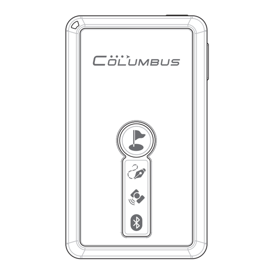
Page 5: Parts Description
Parts Description Part Names Power/Function button Microphone Voice Record Button Power Connector Main Status LED GPS Active Antenna (Built-in) Li-polymer Battery (Built-in) Point of Interest Button Log LED GPS Status LED Bluetooth LED MicroSD Card Slot Hand Strap Hole... -
Page 6: Functions Of Button
Parts Description Functions of Button Power/Function Button Long press the key to turn on or off the power supply. Short press it to change among the three modes: Log + Navigation, Log, and Navigation. Refer to P.17 for detailed operations. Point of Interest Button Short press the button to mark the current position as a POI (Point of interest). -
Page 7: Leds And Audible Alerts
Parts Description LEDs and Audible Alerts There are 3 graphic LEDs on V-900 front face. A status LED is located at the top left. A mini speaker is integrated in the unit. These provide vivid audible and visual indications. Log LED GPS LED Bluetooth LED Log LED indicates the... -
Page 8: Part Names
Function Description The unit is a multifunction GPS data logger used to receive and log geographical position information on an external memory card. You can use the unit and its software for Navigation The unit can be used as a normal Bluetooth GPS receiver, enabling positioning and navigation through a Bluetooth connection with a terminal (smart phone, PDA, computer, etc.) on which a navigation map is installed. - Page 9 Function Description Track Log 1. This data logger can run offline in a standalone mode, in which it is not connected to any terminal. In this mode, it can log the date, time, latitude, longitude, altitude, speed, direction, voice, positioning mode, positioning type, PDOP, HDOP, VDOP, etc.
- Page 10 Function Description Over-speed Alarm This device allows you to set a certain speed value. When your car travels faster than this value, the unit emits sharp audible alarm until the speed falls below the value. When you drive your car at a high speed, this provides you with the convenience to control the maximum vehicle speed solely with the audible alarm of the unit without occasionally checking the speedometer reading, thereby ensuring driving safety.
-
Page 11: Accessories
Accessories AC Adapter The AC adaptor is designed with a wide voltage range(100- 240 V), for global versatility. The adaptor is for indoor use only. Exceeding its specified voltage range can damage the adaptor or device and result in an electric shock accident. Disconnect the power plug immediately after the charging is completed. -
Page 12: About Gps
About GPS The Global Positioning System (GPS) is a satellite-based navigation system made up of a network of 24 satellites placed into orbit by the U.S. Department of Defense. GPS was originally intended for military applications, but in the 1980s, the government made the system available for civilian use. -
Page 13: Getting Started
Getting Started How to Charge the Battery This device is built in with a 1000mAh Li-polymer battery, which allows for hundreds of charge-discharge cycles. Proper charging and discharging can effectively maximize the service life of the battery. ● For indoor applications, use the AC adaptor included in the accessories. ●... -
Page 14: Place And Carry Your Receiver
Getting Started Place and Carry Your Receiver This device is built in with a MTK 51-channels, -159dBm highly sensitive super single chipset. It can easily fix positions at most places in your car. If you bring it with you, you also can use it to fix positions in relatively unfavorable outdoor environments. -
Page 15: Memory Card Selection & File Format
Getting Started Preparing for Use Memory card selection and file format This device supports MicroSD cards of most brands. The supported storage capacity is 64M to 2G. If you need to use the audio recording function, only high-speed memory cards with the capacity of more than 512M are supported because the access speeds of small-capacity cards are limited. -
Page 16: Setting Camera Date And Time
Getting Started Setting camera date and time If the internal clock of your digital camera is incorrectly set, there can be error between the captured photos and track positions. Please adjust the camera time by following the correct procedure below. ●... -
Page 17: Introduction And Operating Modes
Getting Started Start to Use Introduction and changeover of operating modes V-900 has three normal operating modes. You may switch between these modes using the Power/Function button as follows: Long press the for 3 seconds or Long press the for 3 seconds Bluetooth disconnection over 15 Power Off a long beep and shuts down. -
Page 18: Bluetooth Connection
Getting Started Establishing Bluetooth connection with a terminal (illustrated with the Windows Mobile 6.0 system) ® First of all, long press the power button to turn on the device. (1) Open "Setting Bluetooth" (2) Click "New...", then search (3) Find the Bluetooth on smart phone, select Bluetooth device. -
Page 19: Acquiring Position And Navigating
Getting Started Acquiring position and navigating (1) Long press the “power button” for 3s to turn on the device. (2) In a relatively open outdoor environment, point the device reception antenna to the sky. Wait for several minutes until the position is fixed. (The “GPS LED”... -
Page 20: Logging Your Joureny
Logging Your Journey Logging a Track Before running the track logging, you should correctly format your memory card. Refer to P.15 for the operation. After the device is turned on and already in the positioning state, it automatically logs the current track point once per second. A single track may be unlimited in length. -
Page 21: Adding A Voice Mark Point
Logging Your Journey Adding a Point of Interset Adding a voice mark point You can add a voice mark to your traveling track at any time*. This is the simplest and most interesting way to take notes along your journey. After that a symbol can be generated on the map to facilitate your recollection in the future. -
Page 22: Adding A Poi Manually
Logging Your Journey Adding a POI manually Starting a new track You can highlight the current You can terminate the track place of interest anytime and you are logging and start a anywhere. After that a new track on your memory symbol is generated on the card. -
Page 23: Integrating Photos With A Map
Logging Your Journey Integrating Photos with a Map Before using this function, always adjust the camera clock to the synchronized GPS time. Refer to P.16 for the detailed operation. After the time is accurately adjusted, you can bring the device together with the camera and take photos. -
Page 24: Spy Tracking Mode
Logging Your Journey Spy Tacking Mode The device is uniquely designed with the Super long Dormant Tracking Mode Sky Tracking Mode In this mode the device intermittently runs realizing super long battery duration of up to 30 days. In this operating mode, the device is waked up started fixes the position and logs the track information at a certain time interval The Bluetooth function is turned off When the device is standby the main status LED intermittently... -
Page 25: Vehicular Auto On/Off
Logging Your Journey Vehicular Auto ON/OFF When you use the device in your car, please charge it using the car changer and the charging cable. Auto ON/OFF and standard charging can be realized, that is, the device is turned on as soon as the vehicle is started and the power supply to the car cigarette lighter socket is connected, and turned off as soon as the vehicle is shut down and the power supply is disconnected. -
Page 26: Relevant Software
Relevant Software Time Album How to install The device comes with a CD-ROM that presents the "TIME ALBUM" software. The software is specially designed for the device. You may use it to add photos, voice, and other information to a track, which can be viewed and played back on map software. -
Page 27: Configuring Settings
Relevant Software Configuring settings Always configure the following settings when you launch and use “TIME ALBUM” for the first time. (1) You need to correct the GPS (2) Set the vehicle you will take: Car time, which is the GMT time. Mode or Fly Mode. -
Page 28: Adding Voice And Photos
Relevant Software Adding voice and photos (1) Copy tracks, audio records, photos, and other files from your memory card to the hard disk. (2) Click the "Add photos and voice" button. Select the location of the audio records and photos. The software automatically looks for and matches the audio records and photos applicable to the current track and adds them to the track. -
Page 29: Configuring The Device
Relevant Software Configuring the device (1) Click the "Device Setting" button. An interface is launched. Click "Generate” to generate a Config.TXT file. With the help of the USB reader, copy the file to the root directory of your memory card. (2) The “Device Setting”... -
Page 30: Google Earth
Relevant Software Google Earth How to install Click the Google Earth icon and complete the installation. ® Playing back a track Double click the track file (with an extension of KMZ) generated by "TIME ALBUM" to play back the track of your journey in Google Earth . Click an ®... -
Page 31: Details On Track Points
Relevant Software Details on track points This device can record the following types of track point in Google Earth : ® (1) Start point. The data (2) End point. The data (3) Way point. It is the point of the first point of the last most common type of second on each track. -
Page 32: Visual Gps
Relevant Software Visual GPS First, copy "VisualGPSce" from your computer to your PDA/smart phone (Pocket PC OS). Before running the software, establish a Bluetooth connection between the device and the terminal. Refer to P.18 for the operation. (1) Click "VisualGPS", choose (2) Setup com port: baud rate: (3) You can check these "Connect"... -
Page 33: Troubleshooting
Troubleshooting Signal reception Symptoms Causes and Remedy Page ● No satellite signal Battery level is low. Charge the receiver. received ● Avoid using the receiver under an automobile Intermittent windshield that contains metallic wires or has positioning been coated with a film, or in a house, tunnel, or underground parking lot, or on a patio-like Inaccurate land, or near high-voltage cables, or in any... -
Page 34: Bluetooth Connection
Troubleshooting Bluetooth Connection Symptoms Causes and Remedy Page Failure to ● Make sure that the receiver-terminal distance is establish a within the effective range. Bluetooth ● The receiver or terminal has been connected connection with with another Bluetooth device. the terminal ●... -
Page 35: Photos And Audio Records
Troubleshooting Symptoms Page Causes and Remedy Log LED ● Make sure that you have correctly plugged the continuously memory card. flashes and the ● Make sure that the memory card has been device emits formatted to FAT/FAT16. audible alarms ● The device supports Micro SD/T-Flash memory cards with a capacity of 64M - 2G. -
Page 36: Power
Troubleshooting Power Symptoms Causes and Remedy Page The device does ● Battery level is low. Charge the device. not respond when ● You cannot turn it on when charging with the I press the Power button to turn it AC adaptor. ●... - Page 37 Memo...
-
Page 38: Specification
Specification Update Frequency: 1 Hz (Default) Product Specification: ■ Data Bit: 8 Parity: N Stop bit: 1 Dimension: 43(L)x74(W)x9.9(H)mm Output Format: $GGA, $GSA, $RMC, $GSV Weight: 55g Volume: 32cc Bluetooth: ■ Chipset: MTK ARM Super single chip Compatible Bluetooth Device with Serial Port Channels: 51-channel all-in-view tracking Profile (SPP) Frequency: 1575.42Mhz(L1, C/A code), built-in... -
Page 39: Car Charger
Specification Copyright ©2008 VICTORY. All rights Power Supplies: ■ reserved. Main Unit: Built-in rechargeable Lithium polymer battery with capacity (1000mAh) Reproduction, transfer, distribution or storage of part or all of the contents in this document in any The duration of V-900's built-in battery is dependent on your selected operating mode. - Page 40 info Please visit http://cbgps.com for more information. The newest software at http://cbgps.com/software The user manual is made of 100% recyclable paper pulp. English Ver 1.2c PRINTED IN CHINA 3 G 0 9 0 5 V1 . 2...
Need help?
Do you have a question about the V 900 and is the answer not in the manual?
Questions and answers