Garmin GPSMAP 178C Owner's Manual
Color chartplotter & depth-finder
Hide thumbs
Also See for GPSMAP 178C:
- Owner's manual (134 pages) ,
- Specifications (2 pages) ,
- Manual (2 pages)
Table of Contents
Advertisement
Advertisement
Table of Contents

Related Manuals for Garmin GPSMAP 178C


Summary of Contents for Garmin GPSMAP 178C
- Page 1 GPSMAP 178C owner’s manual...
- Page 2 Information in this document is subject to change without notice. Garmin reserves the right to change or improve its products and to make changes in the content without obligation to notify any person or organization of such changes or improvements.
-
Page 3: Introduction
Part Two is divided into sections that provide detailed references to the advanced features and opera- tions of the GPSMAP 178C Sounder. This allows you to concentrate on a specifi c topic quickly and look up detailed information about the GPSMAP 178C Sounder. -
Page 4: Fcc Compliance
FCC Compliance FCC Compliance The GPSMAP 178C Sounder complies with Part 15 of the FCC interference limits for Class B digital devices FOR HOME OR OFFICE USE. These limits are designed to provide more reasonable protection against harmful interference in a residential installation, and are more stringent than “outdoor” require- ments. -
Page 5: Warnings And Cautions
– and, as always, the user is responsible for their prudent use. Use the GPSMAP 178C at your own risk. To reduce the risk of unsafe operation, carefully review and understand all aspects of this Owner’ s Manual—and thoroughly practice operation using the simulator mode prior to actual use. -
Page 6: Warranty And Serial Number
Garmin retains the exclusive right to repair or replace the unit or software or offer a full refund of the purchase price at its sole discretion. SUCH REMEDY SHALL BE YOUR SOLE AND EXCLUSIVE REMEDY FOR ANY BREACH OF WARRANTY. -
Page 7: Capabilities
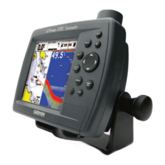
Designed for detailed electronic charting capability, the Garmin GPSMAP 178C Sounder is a pow- erful navigation device that can give you the information you need: Precision Performance • High-contrast, 256-color LCD screen with backlighting • 12-channel parallel receiver tracks and uses up to 12 satellites for fast, accurate positioning •... -
Page 8: Packing List
Before installing and getting started with your unit, please check to see that your package includes the following items. If any parts are missing, please contact your Garmin dealer immediately. Standard Package: • GPSMAP 178C Sounder Unit •... -
Page 9: Table Of Contents
Introduction ......i Preface/Registration ..... i Software License Agreement . -
Page 10: How To" Index
“How To” Index The list to the right is provided to help you quickly fi nd some of the more important procedures you may use on your new GPSMAP 178C. viii TO DO THIS: Turn the unit on or off ......... . 4 Adjust screen backlighting . -
Page 11: Section One: Getting Started
(ZOOM) OUT Key The OUT key adjusts the map scale to display a larger area with less detail. (Zooms out) (ZOOM) IN Key The IN key adjusts the map scale to display a smaller area with more detail. (Zooms in) PAGE Key The PAGE key selects the main pages in sequence and returns display from a submenu page. -
Page 12: Selecting Options
Selecting Options and Entering Data You can select and activate options and enter data to customize the GPSMAP 178C Sounder to fi t your requirements. You can use the ENTER/MARK key and ARROW KEYPAD to select options, enter names and numbers in data fi... -
Page 13: Entering Data
Naming a waypoint or placing any sort of data that has not been predefi ned requires the use of both the ARROW KEYPAD and the ENTER/MARK key. To enter a name or number in a data fi eld: 1. Once you have accessed a page with programmable data fi elds (e.g. ‘ Waypoint Edit’) you can use the ARROW KEYPAD to move the cursor (Highlight) to fi... -
Page 14: Initializing The Receiver/Power On
GPSMAP 178C Sounder Warning Screen Initializing the Receiver The fi rst time you power up your GPSMAP 178C Sounder, the receiver must be given an oppor- tunity to collect satellite data and establish its present position. To ensure proper initialization, the GPSMAP 178C Sounder is shipped from the factory in AutoLocate mode, which allows the receiver to “fi... -
Page 15: Initializing The Receiver
Once the receiver has collected information from at least three satellites, the top of the screen dis- plays either “Ready (2D or 3D)”, and the GPSMAP 178C Sounder is ready for use. Getting Started Initializing the Receiver Point to your approximate loca- tion and press ENTER/MARK. -
Page 16: Tour/Backlighting
The GPS Information Page appears as the receiver begins acquiring satellites. From this or any other page, you may also adjust the screen backlighting. The GPSMAP 178C’ s adjustable screen backlighting is controlled with the POWER key. The back- light can cycle through minimum, user-defi ned, and maximum backlight levels by repeatedly pressing the POWER key. -
Page 17: Simulator Mode
While in Simulator mode, a ‘Running Simulator’ message appears after 2 minutes of inactivity. Now you’re ready to continue the rest of the simulated tour. Keep in mind that the GPSMAP 178C Sounder does not track satellites in simulator mode, and this mode should never be used for actual navigation. -
Page 18: Main Pages/Map Page
Map Page Main Pages The Map Page is one of six main pages used in the GPSMAP 178C Sounder’ s system. The six main pages are the Map Page, Map/Sonar Split Page, Sonar Page, Compass Page, Highway Page, and Active Route Page. -
Page 19: Map Cursor
Using the Map Cursor Working from the Map Page is a simple process that centers around the use of the cursor. Con- trolled by the ARROW KEYPAD, the cursor is an important tool that can be used to pan to other map locations, mark and edit waypoints and routes, and review position data of on-screen map items and waypoints. -
Page 20: Marking Waypoints
Getting Started Marking Waypoints Press ENTER/MARK after entering the name. You can choose from a list of useful symbols. There are two Diver Down waypoint symbols to select from: the International and U.S. versions. To mark your present position: 1. Hold down the ENTER/MARK key until the ‘New Waypoint’ window appears then release the key. The window shows a default three-digit waypoint name/number (001), symbol (dot), and position. -
Page 21: Using The Nav Key
For our simulated trip, you’re going to select a pre-programmed tour route using the fi rst method. This also shows how the MENU key is used throughout the GPSMAP 178C Sounder system to provide tab style options and functions. Let’ s start by changing the position to where the practice route is located. -
Page 22: Simulated Tour
Getting Started Simulated Tour You can also Invert a route to follow it in reverse. The Set Position, Track Control, Track and Speed fi elds only show while in simulator mode. To activate the practice route stored in memory for navigation: 1. -
Page 23: Reviewing/Creatingmap Waypoints
You’ll now have a clearer picture of the route you are navigating. Keep in mind that when you exceed the usable range of the built-in database or the optional MapSource or BlueChart data in use, the range fi eld displays ‘overzoom’ to indicate that you should exercise extreme caution using the map data. -
Page 24: Map/Sonar Split Page
You may adjust the size of the split (pg 32). Press PAGE key to proceed to the Sonar Page. Sonar Page The Sonar Page is where your GPSMAP 178C Sounder becomes a powerful fi shfi nder. The top left of the screen contains data fi elds, while the Adjustment Bar above the data fi elds allows direct access to the settings most commonly changed while using the Sonar Page. -
Page 25: Getting Started
Using the Adjustment Menu The Adjustment Menu allows direct access to the settings and features most commonly used on the Sonar Page. There are 10 main adjustment options available: Range, Zoom, View/ Span, Gain, Target Level, Whiteline, Frequency, Depth Line, Noise Reject, and Scroll. The currently selected option appears in the upper left of the display with up and down arrows on either side of the option name. -
Page 26: Compass Page
Pointer Arrow Compass Page Now that we’re navigating to an actual destination, let’ s move on to the GPSMAP 178C Sounder’ s navigation pages by pressing the PAGE key. Compass Page The Compass Page provides graphic steering guidance to a destination waypoint, with an emphasis on the bearing to your destination and current direction of travel. -
Page 27: Highway Page
Page as your primary navigation page (in lieu of the Compass Page) when your main concern is follow- ing a defi ned course. Whenever the GPSMAP 178C Sounder is in simulator mode, you can also adjust your speed and course from the Highway Page using the ARROW KEYPAD. As you head toward each waypoint in the tour route, try adjusting your boat speed and course to get a feel for how the Highway Page works. -
Page 28: Changing Data Fields
Getting Started Highway Page You may choose from several different types of data Notice that as you get off course, the highway moves to give you graphic guidance to get back on course. You can zoom in or out on the Highway display for a smaller or larger view. Five available set- tings range from 1X to 16X, with a default setting of 8X. -
Page 29: Changing Data Fields/Active Route Page
The layout of the data fi elds may also be changed to show more fi elds (with a smaller number size) or less fi elds (with a larger number size). This setting is available on all of the Main Pages, except the Active Route Page. -
Page 30: Main Menu Page/Deleting Waypoints
As you’ve seen, the primary pages provide map, sonar, and navigation information. The tour’ s last page is the Main Menu page, which allows access to the GPSMAP 178C Sounder’ s waypoint, route, and planning functions, as well as various operational and navigation setup features, and celestial and tide data. -
Page 31: Powering Off Unit
2. When the screen is blank, release the POWER key. The next section of the manual describes the pages and functions of the GPSMAP 178C Sounder in detail. If you are unable to locate a specifi c option or function, please refer to the Index. -
Page 32: Section Two: Reference
• When suffi cient map coverage is not available to keep the boat centered, the boat icon moves toward the edge of the display. When the ARROW KEYPAD is pressed, the GPSMAP 178C enters cursor mode. In cursor mode: • The cursor can be moved over the map display using the ARROW KEYPAD. -
Page 33: Using The Cursor
• Whenever you zoom in cursor mode, the cursor is centered on screen. • To return to position mode, press the QUIT key. When the cursor reaches the edge of the map, the unit may pause as it loads new map data. -
Page 34: Zooming
The scale value represents the distance from one end of the scale bar to the other. The GPSMAP 178C’ s system has a built-in worldwide database to 20 mi, with more detailed coverage available through the use of the optional BlueChart or MapSource data. The GPSMAP 178C displays cartography as long as there is chart information available for the range you’ve selected. -
Page 35: Map Page Options
Map Page Options Many features of the GPSMAP 178C are menu driven. Each of the main pages have an options menu, allowing you to custom tailor the corresponding page to your preferences and/or select special features that specifi cally relate to that page. The data window, located at the top of the main pages provides a user-selectable layout of various types of useful data. -
Page 36: Map Page Options
Reference Map Page Options Cursor Coordinates Distance and Bearing Map Cursor Full screen map shown Main Menu— Map Confi guration Tab • Measure Distance— allows you to measure the bearing and distance between any two points on the map display. To measure the Bearing/distance between two points: 1. - Page 37 General Tab Detail— Most, More, Normal, Less, Least: controls how much map detail displays. Those features which have a specifi ed scale or turned “Off” are unaffected by this setting. Orientation— North Up— fi xes the top of the map display to a north heading; Track Up Below—...
- Page 38 Some types of data only shows up to certain zoom scales. Navaids Tab— Symbol Set— Auto, GARMIN, NOAA, International: controls the desired navaid symbol set. Auto - BlueChart maps are drawn using symbols similar to the NOAA/NIMA standard. Non- BlueChart maps are drawn using traditional Garmin symbols.
- Page 39 Nav Line Tab— Heading Line— On/Off: draws an extension from the end of the boat icon in the direction of travel. Bearing Line— On/Off: toggles the black/white line which points to the current navigation point. Course Line— Auto, Off, 20 ft.-800 mi.: sets the maximum zoom scale at which the desired course line should appear on the screen.
- Page 40 Reference Map Page: Options Changing Page Layout Highlight the fi eld you wish to change 3. The current setting displays, press ENTER to change. Use the ARROW KEYPAD to highlight the desired setting, then press ENTER. 4. Press QUIT when fi nished. •...
- Page 41 • SPEED – Speed over ground • TIME OF DAY – Current time • TIME TO DESTINATION – Time to fi nal waypoint • TIME TO NEXT – Time to next waypoint • TO COURSE – Bearing to desired track •...
-
Page 42: Map/Sonar Split Page
Reference Map/Sonar Split Page Map/Sonar Split Page You may resize the split to the left or right. Map/Sonar Split Page The Map/Sonar Split Page combines the Map Page on the left half with the Sonar Page on the right by default. The menu options for this page are the same as the Map Page. Any setting changes made from the Map/Sonar Split Page will also affect the Map Page. -
Page 43: Sonar Page
Sonar Page The Sonar Page is where your GPSMAP 178C Sounder becomes a powerful fi shfi nder. Fish are displayed as colored arches or as fi sh icons in three different sizes. Thermoclines are shown as shades of blue. The sonar display may also be set to show a split screen view of a zoomed portion of the sonar, bottom lock (display scaled from the bottom up), or a combination of these options (see pg. -
Page 44: Adjustment Menu
Reference Sonar Page: Adjustment Menu Zoom Adjustment Range Adjustment 4X Split Zoom Display (Dual Frequency Mode) 3. Press ENTER or QUIT to exit the adjustment window; or press LEFT/RIGHT on the ARROW KEYPAD to view another adjustment window. To change a setting back to ‘Normal’ or ‘Auto’: 1. - Page 45 Once activated, the zoomed picture becomes the Sonar Page display. You may also cycle through the sonar zoom display levels by pressing the IN or OUT keys. The Zoom function can be deactivated by pressing the OUT key until the ‘No Zoom’ setting appears. View/Span—...
-
Page 46: Sonar Page Options
Sonar Page Options The GPSMAP 178C Sounder’ s Sonar Page features a menu page that provides access to additional functions and to layout and data fi eld options. -
Page 47: Sonar Page Options
• Show/Hide Pointer — allows you to reference sonar items and mark underwater waypoints. This makes it easier to fi nd and use an object such as a stump for a future fi shing location. When using this feature, the Sonar Page pauses. The pointer does not move off the paused display and cannot show an area that has scrolled off the screen. - Page 48 Reference Sonar Page Options Double-Arrow ‘ Size Split’ Menu Resizing the Split Sonar Display Options Fish Symbols Off— All available information is displayed . Suspended targets displays as fi sh symbols. Background information is displayed . Same as above with the target depth attached. Suspended targets display as fi...
-
Page 49: Sonar Tab Options
If the unit is unable to track the bottom for any reason, the digits in the depth window fl ashes on and off to alert you that the unit is not tracking the bottom. Scale — controls the depth ‘Scale’ displayed vertically along the right side of the graph. The depth ‘Scale’... - Page 50 Reference Sonar Page Options Keel Offset: Transducer at Surface Enter (+) positive number to show depth from bottom of keel Keel Offset: Transducer at Bottom of Keel Enter (-) negative number to show depth from surface Calibrating the Speed Sensor To calibrate the water speed: 1.
-
Page 51: Compass Page
Once you start moving, the pointer is correct. The GPSMAP 178C’ s Compass Page features a menu page that provides access to layout and data fi eld options. The data window, located at the top of the page, provides a user-selectable layout of vari- ous types of useful data. -
Page 52: Highway Page
Highway Page Highway Page When a Go To, TracBack, or route has been activated, the GPSMAP 178C’ s Highway Page provides digital and graphic steering guidance to the destination. The top half of the Highway Page features user-selectable data fi elds that display useful navigation data. The bottom section of the screen provides visual guidance to the waypoint on a graphic highway display. -
Page 53: Highway Page Options
30-31. Active Route Page When a route is activated in the GPSMAP 178C Sounder system, the Active Route page shows each waypoint of the active route, along with various, user-selectable types of data. For additional details on the Active Route Page, see page 64. -
Page 54: Waypoints
Creating and Using Waypoints The Garmin GPSMAP 178C stores up to 3000 alphanumeric waypoints with a user-defi ned icon, comments, depth, or water temperature available for each waypoint. Waypoints can be created using three basic methods: •... -
Page 55: Creating Waypoints Graphically
When you move the cursor over a map item, you see a highlighted description of that item. The GPSMAP 178C uses the map item text shown on the cartography as the default name and symbol for the new waypoint. -
Page 56: Additional Options For Creating Waypoints
Reference Creating Waypoints Highlight the position fi eld and use the ARROW KEYPAD to enter the desired position coordinates. Select a point from which to project a new waypoint. Additional Options For Creating Waypoints Waypoints may also be created by manually entering position coordinates through the Points tab of the Main Menu. -
Page 57: Waypoint Menu Options
3. To select another location from which to project a waypoint, highlight the fi eld next to ‘From’ and press ENTER. The ‘Find’ screen appears. Highlight the desired type of location ( waypoints, cities, etc.) and press ENTER. Use the submenus to narrow down your search (for more information see ‘Find’... -
Page 58: Reviewing And Editing Waypoints
Reference Reviewing/Editing Waypoints Waypoint Review Page— Highlight ‘OK’ and press ENTER to exit/save changes. Changing a Waypoint symbol. Reviewing and Editing Waypoints Once you have created and stored a waypoint, it may be modifi ed, reviewed, renamed, moved, or deleted at any time through the Waypoint Review and Waypoint Edit pages. To access the Waypoint Review page: 1. -
Page 59: Editing Waypoints
To change the comment/position coordinates/depth/water temperature: 1. Highlight the desired fi eld and press ENTER. 2. Use the ARROW KEYPAD to edit/enter the data. To drop to the next line, press to the right on the ARROW KEYPAD. Press ENTER when done. On the Waypoint Review and Waypoint Edit pages, you may also delete the selected waypoint, view the waypoint on the map, and move the waypoint on the map. -
Page 60: Waypoint Lists
Options Menu Waypoint Lists The GPSMAP 178C’ s Main Menu Page features two waypoint submenu tabs, ‘User’ and ‘Proxim- ity’, that let you manage a large number of waypoints quickly and effi ciently. The submenu tabs also provide a continuously updated proximity waypoint alarm function that can be used to defi ne an alarm circle around submerged hazards, shallow waters, etc. -
Page 61: Proximity Waypoint List
Once a waypoint is deleted from the list, it cannot be recovered from the unit. It is advisable to backup important waypoints to a computer using an optional PC cable and interface software, save them to a data card, or write them down by hand. To delete an individual waypoint from the ‘User’... - Page 62 Reference Waypoint Lists Proximity Waypoints List Proximity Waypoint Proximity Circle A dashed circle appears showing the alert boundary for the proximity waypoints. To add a proximity waypoint: 1. Use the ARROW KEYPAD to highlight an empty space on the Proximity list and press ENTER. The ‘Find’...
-
Page 63: Going To A Destination
Going to a Destination Using the NAV key, the GPSMAP 178C provides three ways to navigate to a destination: Go To Point, Follow Route, and Follow Track (TracBack). Once you are actively navigating, you see a straight line that always runs from your current location to the destination on the Map Page. The easiest method for selecting a destination is the ‘Go To’... -
Page 64: Tracback Navigation
Reference Going to a Destination/ TracBack Navigation ‘Go To MAP Point’ allows you to navigate to a spot on the map that is not a waypoint or map item. Highlight ‘Save’ and press ENTER to save an active track log. To activate an existing waypoint or map item as a ‘Go To’... -
Page 65: Tracback Navigation
ENTER. Once a TracBack has been activated, the GPSMAP 178C takes the track log currently stored in memory and divides it into segments called ‘legs’. Up to 50 temporary ‘turns’ (BEGIN, TURN 1, TURN 2, TURN 3,..., TURN X, END) are created to mark the most signifi... -
Page 66: Mob: Man Overboard
For more information on setting up the Track options and saved tracks, see pages 75. MOB Key The GPSMAP 178C’ s Man OverBoard function (MOB) lets you simultaneously mark and set a course to a position for quick response to emergency situations. -
Page 67: Routes
The second way is to ‘Edit as Text’ from the Route Review page, allowing you to see a list of the waypoints as you create, review, or modify the route. All of the GPSMAP 178C’ s route functions are accessed through the Main Menu page or the NAV key. -
Page 68: Following
Reference Creating a Route/ Following a Route Choose the type of point you want to add to the route. Choose a waypoint from either the ‘By Name’ or ‘Nearest’ tab list. To create a route using text from the Route Review page: 1. -
Page 69: Route List Page
1. Press the NAV key, highlight ‘Stop Navigation’ and press ENTER. Route List Page The GPSMAP 178C Route List page (‘Route’ tab of the Main Menu) displays all the routes currently stored in memory, along with a descriptive name for each route. By pressing MENU while on the Route List page, the following menu options appear: ‘New Route’... -
Page 70: Route Review Page
Reference Route Review Page Route Name Data Fields Route Points Data Totals Route Review Options Menu Route Review Page Once you have created a route, the Route Review page allows you to edit a selected route. To access the Route Review page: 1. -
Page 71: Editing Routes
• Edit on Map — review and modify the route displayed for each point (waypoint or map item) on a map page. You may also use the cursor to insert a new route point on a route leg, review the waypoint or map item. -
Page 72: Editing Routes
(shown) to create a new route point. The GPSMAP 178C’ s route edit mode also allows you to insert a new route point in any route leg using the map cursor. To insert a new point between two existing route waypoints: 1. - Page 73 • Trip Planning — The Route Review and Active Route pages also display trip-planning information for each leg or the entire route. Available information includes Course, ETA, Fuel (to point), Leg Distance, Leg Fuel, Leg Time, Sunrise and Sunset (at point location) and Time To (point). To use the trip planning feature: 1.
-
Page 74: Active Route Page
Active Route Page Menu Options Active Route Page Whenever you have activated a route in the GPSMAP 178C, the Active Route page shows each point (waypoint or map item) of the active route, with the point name, distance and choice of Course, ETA, Fuel to point, Leg Distance, Leg Fuel, Leg Time, Sunrise and Sunset at point location, or Time To point for each point from your present position. -
Page 75: Find Key
Find Key The FIND key allows you to search the unit for user waypoints, map items, and any optional BlueChart or MapSource information loaded on a data card. Press the FIND key to search for items from your current location by default. You may also search from other locations. When you press FIND, a list of available items to search for appears. -
Page 76: Find Options
Reference Find Options Additional Information Tabs Distance, Bearing, Coordinates of item Additional Option Buttons Additional Information Window Find Menu Options To view details about an item: 1. With the desired item highlighted in the search results list, press ENTER. 2. An Information page appears with details about the item organized in a tabbed format. Depending on the type of item, additional options are available for viewing the item on the map, viewing notes on a MapSource or BlueChart map, viewing a tide chart, viewing a list of maps on your data card, and viewing the next item in the search results list. -
Page 77: Main Menu Page
“tab” format. The Main Menu page is avail- able from any page in the GPSMAP 178C’ s system, and is accessed through the MENU key. See pages 2-3 for additional instructions changing settings and entering data. -
Page 78: Main Menu: Gps Tab
As soon as the GPSMAP 178C has collected the necessary data from the best satellites in view to calculate a fi x, the status fi eld indicates a 2D or 3D status. The unit then updates the position, date and time. -
Page 79: Waas Capability
WAAS satellites are numbered 33 or higher when viewing the sky view on your GPSMAP 178C. Initial reception of the WAAS signal may take up to 15-20 minutes, then 1-2 minutes afterwards. When WAAS differential correction has been received for GPS satellites (numbers 32 or below), a ‘D’... - Page 80 Reference Main Menu: GPS Tab When the GPSMAP 178C is using a differential correction signal (either WAAS or DGPS), a “D” is displayed at the bottom of the signal strength indicator bars for the satellites that are corrected. The status fi eld shows one of the following conditions: •...
- Page 81 NOTE: If a DGPS receiver is attached to the unit and Garmin DGPS, RTCM In/NMEA Out, or Other DGPS is enable on Port 2, WAAS is automatically disabled (WAAS Off). It is not possible for the GPSMAP 178C to receive WAAS and DGPS corrections at the same time.
- Page 82 Reference Station Name Date Tide Chart Event Times Main Menu—Tide Tab You can select from a list of nearest stations. Tide Tab— shows a graphical chart that displays tide station information in a 24-hour span starting at midnight station time. You can choose from different dates and over 3000 tide stations around the USA coastline, Alaska, Hawaii, western Canada and several of the Caribbean islands.
-
Page 83: Main Menu: Tide Tab
To select the nearest tide station from you current location: 1. From the “Tide” tab, highlight the ‘At’ fi eld and press ENTER. 2. Highlight the desired station of the list and press ENTER twice. If you are not within this range, you see a message “None Found”. Use the ‘Nearest To Other’ Find option and select a location closer to a tide station. -
Page 84: Trip Tab
Reference Main Menu: Trip Tab/ Celestial Tab Main Menu— Trip Tab Date/Time Position Sun/Moon Skyview Event Times Window Moon Phase Position Overhead (90°) 45° 20° Horizon (0°) Main Menu— Celestial Tab Trip Tab— displays Trip Odometer, Moving Average Speed, Total Average Speed, Maximum Speed, Stopped Time, Moving Time, Total Time, and Odometer. -
Page 85: Track Tab
Points Tab— contains the ‘User’ and ‘Proximity’ waypoint lists. See page 50. Route Tab— contains a list of available routes. See page 59. Track Tab— lets you specify whether or not to record a track log (an electronic ‘breadcrumb trail’ recording of your path), defi... - Page 86 Reference Main Menu: Track Tab Reviewing a saved track The track name automatically appears when highlighted on the ‘Saved’ list and NAV is pressed. Saved Submenu Tab— manages a list of any saved track logs, allows TracBack activation, map display of saved logs.
-
Page 87: What Is A Maritime Mobile Service Identity (Mmsi)
Position Report and as a unique identifi er to the Coast Guard when used in an emergency Distress Call. In order to obtain a Maritime Mobile Service Identity (MMSI) number, users must register their VHF radio with the FCC (Form 605). Garmin does not supply this number! - Page 88 For more information regarding MMSI’s visit: http://www.navcen.uscg.gov/marcomms/gmdss/ mmsi.htm. HOW CAN GARMIN HELP YOU WITH DSC? To receive Distress Calls or Position Reports, you must have a DSC-equipped chartplotter as well as a VHF radio with DSC support. During normal, non-emergency Position Report communication, Channel 70 (156.525 MHz) has been set aside as the VHF/DSC digital call channel.
- Page 89 When the Garmin GPSMAP 178C is connected to a VHF with DSC support, the GPS unit displays a Call List, Log, and a Directory available to store incoming information received from another user’ s DSC capable VHF/GPS combination.
-
Page 90: Dsc Directory
Reference Main Menu: DSC Tab DSC Entry Review DSC Log DSC Call List The DSC Call List displays the current calls received. The GPS can manage up to 50 calls. When ‘calls’ are received, they are updated constantly to give the most current information, even if the unit is left unattended. - Page 91 DSC users. DSC Setup Garmin chartplotters have the ability to turn DSC ‘On’ or ‘Off’. This option is benefi cial for users who have more than one GPS chartplotter. If you want only DSC to display on a particular chartplotter, turn DSC off on the remaining Garmin chartplotters that support DSC.
-
Page 92: Card Tabs
Card Tab— interface control for saving waypoints, routes and tracks to a data card.When data is saved to a data card, it may be exchanged with other compatible units and Garmin’ s MapSource PC program. To transfer data to/from a data card: 1. -
Page 93: Temp Tab
Map Tab— contains setup options for the Map Page. See page 25. Hiway Tab— contains setup options for the Highway Page. See page 43. Temp ( Temperature) Tab— displays the water temperature log (if equipped with a temperature transducer/sensor). The chart reads from right to left, so that the most recent temperature measured is displayed on the far right side of the chart. -
Page 94: Units Tab
• Defaults – restores settings on System page to default values. • All Unit Defaults – restores all settings to Garmin’ s original setup values for the entire unit. Units SubmenuTab— defi nes settings for Position Format, Map Datum, Heading, Distance, Speed, Elevation, Depth, and Temperature. - Page 95 If you are using a map or chart in conjunction with your GPS, make sure the settings under the ‘Units’ tab of the GPSMAP 178C match that of the map or chart. This infor- mation should be displayed somewhere on the map or chart.
-
Page 96: Comm Tab
GPSMAP 178C to external NMEA devices, a DGPS beacon receiver, a personal computer, another Garmin GPSMAP 178C, etc. If a DGPS receiver is used, WAAS capability is automatically turned to ‘Off’. The unit supports two input/output ports. See page 96 for more information on wiring and NMEA information. - Page 97 Port 2: • Garmin DGPS – used to connect the GPSMAP 178C with a Garmin DGPS beacon receiver. • Other DGPS – allows DGPS input using a standard RTCM format, without any output capabili- ties. • NMEA In/NMEA Out – supports the input/output of standard NMEA 0183 data and DSC. You may also adjust the NMEA output.
- Page 98 If ‘Garmin DGPS’ or ‘RTCM In/NMEA Out’ format is selected, additional fi elds are provided to control a Garmin differential beacon receiver directly from your GPSMAP 178C. You may have the unit automatically scan for the DGPS beacon signal or you can enter the beacon frequency and bit rate on the unit and the information is used to tune the beacon receiver.
-
Page 99: Nmea Interface
NMEA Interface If you are going to interface the GPSMAP 178C with another piece of equipment (such as a radio or autopilot), the unit needs to be set to output NMEA data. More information on wiring and NMEA data may be found on page 96. -
Page 100: Alarm Tab
Advanced NMEA Setup Page Main Menu—Alarm Tab (System Submenu) GPSMAP 178C NMEA Sentence Output (NMEA version 3.01 compliant) Always transmitted: GPRMC, GPGGA, GPGLL, GPBWC, GPVTG, GPXTE, GPRMB, SDDBT, SDDPT, SDMTW, SDVHW Switchable sentences: GPGSA, GPGSV, GPWPL, GPRTE Garmin proprietary: PGRME, PGRMZ, PGRMM Alarm Tab—... -
Page 101: Set Alarms
and off. Sonar Submenu Tab Shallow Water/ Deep Water – set alarms to sound when you enter an area of specifi ed depth that is too shallow and/or too deep. You must be receiving sonar data for this function to work. Water Temperature –... -
Page 102: Appendix A: Installation
3. Once the GPSMAP 178C unit has been installed, connect the cable to the antenna connector on the back of the display unit. Make sure that you turn the antenna cable connector 1/4 turn clock-... -
Page 103: Unit Installation
• The mounting surface should be heavy enough to support the unit and protect it from exces- sive vibration and shock. • For GPSMAP 178C with a built-in internal antenna, it should be mounted in a location that has the clearest, most unobstructed view of the sky in all directions to ensure the best reception. - Page 104 Appendix A Unit Installation Installing the Unit on the Mounting Bracket 1. Align the slot on the back of the unit with the long mounting knob and slide in place. It may be necessary to adjust the long mounting knob to spread the bracket arms apart. (Turn counter-clock- wise to widen the bracket arms, clockwise to tighten.) 2.
- Page 105 Flush Mounting the GPSMAP 178C External Antenna Unit The GPSMAP 178C External Antenna only can be fl ush mounted on a fl at panel. When fl ush mounting the GPSMAP 178C, be sure to choose an appropriately sized location for the unit. Check that all cables reach the unit mounting location before beginning installation.
-
Page 106: Wiring And Interfacing
703-836-4229 FAX www.rtcm.org Connecting the Power/Data Cable The power/data cable connects the GPSMAP 178C to 10-35 volt DC system and provides interface capabilities for connecting external devices. The color code in the diagram below indicates the appro- priate harness connections. -
Page 107: Selecting A Transducer
Since many mounting locations vary, there are a variety of standard and optional transducers, and accessories which are available. See your local Garmin dealer or contact Garmin to help you in your selection of optional transducers and accessories. -
Page 108: Transom Mount Installation
Proper transducer installation is key to getting the best performance from your new unit. If the transducer lead is too short, extension cables are available from your Garmin dealer. DO NOT cut the transducer lead or any part of the transducer cable, as this voids your warranty. The cable cannot be spliced and connected to any existing (Garmin or non-Garmin) transducer cables. -
Page 109: Shoot-Thru-Hull Installation
To avoid drilling a hole to mount a thru-hull transducer, a transom mount transducer may be used with epoxy inside a boat (“shoot-thru-hull” installation). For a transducer to be mounted inside the hull (shoot-thru, not thru-hull), the boat must be fi berglass, no core (contact your boat manufacturer if you are unsure). -
Page 110: Testing The Installation
Press the POWER button and the GPSMAP 178C should power on. If the unit fails to power on, verify that the wiring adapter is seated properly in the back of the unit, the Red and Black wires are connected to the correct polarity, and that the fuse is installed and not blown. -
Page 111: Installing And Removing Data Cards
If you insert a data card and get a ‘card format not recognized’ message, try removing the card and reinserting it. If the card is still not recognized, contact the Garmin or your Garmin dealer for assis- tance. Data cards are not waterproof, should not be exposed to moisture or excessive static charges, and should be stored in the case supplied with the card. -
Page 112: Appendix B: Loran Td
Appendix B Loran TD On the Units Tab of the Main Menu, press MENU, then highlight ‘Loran TD On’ and press ENTER to select Loran TD. Or, highlight the Position Format fi eld, highlight ‘Loran TD’ and press ENTER to select Loran TD. -
Page 113: Loran Td Setup
Because of this the unit can navigate to a TD coordinate anywhere in the world. For more information on Loran TDs, you may download Garmin’ s “Loran TD Position Format Handbook” from the Garmin web site. -
Page 114: Appendix C: Map Datums
Appendix C Map Datums The ‘ User’ datum is based on a WGS-84 Local datum and is an advanced feature for unlisted or custom datums. To learn more, check your local library or on the world wide web for educational materials on datums and coordinate systems. Adindan Adindan- Ethiopia, Mali, Senegal, Sudan Afgooye... -
Page 115: Map Datums
Kandawala Kandawala- Sri Lanka Kerguelen Islnd Kerguelen Island Kertau 1948 West Malaysia, Singapore L. C. 5 Astro Cayman Brac Island Liberia 1964 Liberia 1964- Liberia Luzon Mindanao Luzon- Mindanao Island Luzon Philippine Luzon- Philippines (excluding Mindanao Isl.) Mahe 1971 Mahe 1971- Mahe Island Marco Astro Marco Astro- Salvage Isl. -
Page 116: Appendix D: Messages
Arrival At Waypoint— You have arrived at the destination waypoint. Basemap Failed Unit Needs Repair— Internal problem with the unit. Contact your dealer or Garmin Customer Service (pg. iv) to have the unit serviced. Battery Alarm— Specifi ed amount of input voltage has been detected. - Page 117 Shallow Water Alarm— Specifi ed shallow water alarm depth has been detected below transducer. Sonar Failed Unit Needs Repair— Internal problem with the unit. Contact your dealer or Garmin Customer Service (page. iv) to have the unit serviced. Appendix D Messages Track Already Exists: <track name>—...
-
Page 118: Appendix E: Navigation Terms
Appendix E Avg Speed— The average of all second-by-second speed readings since last reset. Bearing (BRG)— The compass direction from your present position to a destination waypoint. Navigation Terms Course— The desired course between the active ‘from’ and ‘to’ waypoints. Distance (Dist)—... - Page 119 Odometer— A running tally of distance travelled, based upon the distance between second-by-second Appendix E position readings. Off Course— The distance you are off a desired course in either direction, left or right. Also referred Navigation Terms to as ‘cross-track error’ or ‘course error’. Speed—...
-
Page 120: Appendix F: Time Offsets
Appendix F Time Offsets A simple way to determine your local time offset is how many hours you are behind or ahead of UTC (also called ‘Greenwich’ or ‘zulu’ time). Example: EST (Eastern Standard Time) is 5 hours behind UTC, so your offset would be -5. Adding one hour for day- light savings would make EDT (Eastern Daylight Time) - 4. -
Page 121: Appendix G: Understanding Sonar
In Example 3 (page 113) you can see that the branches and the fi sh where the strongest second- ary returns are indicated in black on the display. That is brief description of how your GPSMAP 178C operates. Let’ s take a look at how this data can help you to improve your fi shing. -
Page 122: Transducer Coverage
When using the GPSMAP 178C in ‘Dual’ frequency mode, the unit transmits both 50kHz and 200kHz signals at the same time. The ‘Dual’ frequency capability of the GPSMAP 178C allows you to have a large coverage area and still retain good bottom resolution. When in ‘Dual’ frequency mode the unit uses the narrow cone angle (200kHz) to display detailed bottom information, keeping “Dead... - Page 123 Understanding the Graph It is important to understand that the unit does not display a 3-D representation of the underwater environment. The unit can display multiple things at the same time, but cannot determine where the return originated – only when it was received. Examples 1 and 2 provide a look at the underwater world from a top view, and illustrate how these views would be displayed on the graph.
-
Page 124: Understanding The Graph
Whiteline The GPSMAP 178C can help you to determine if the bottom is hard or soft. When the sonar soundwaves are refl ected back by the bottom, a hard bottom returns a stronger signal than a soft bottom. -
Page 125: Understanding The Graph
Appendix G One of the unique features offered by Garmin is See-Thru technology. See-Thru technology allows the GPSMAP 178C to “see” through thermoclines and helps locate fi sh where they live; and fi sh love Understanding the Graph thermoclines! A rough defi nition of a thermocline is a break in water where the water temperature changes faster than the water above it. -
Page 126: Specifications
AutoLocate: Approx. 2 minutes Update Rate: 1/second, continuous GPS Accuracy: Position*: <15 meters (49 feet), 95% typical* Velocity: 0.05 meters/sec steady state DGPS (USCG) Accuracy: Position: 3-5 meters (10-16 feet) with optional Garmin DGPS receiver, 95% typical* Velocity: 0.05 meters/sec steady state... -
Page 127: Appendix H: Specifi Cations/Unit Care
After submersion, be certain to remove the data card and dry the compartments before reuse. To resolve problems that cannot be remedied using this guide, contact Garmin Customer Support in the U.S.A. at 800-800-1020 or Garmin Europe at 44-1794-519944. -
Page 128: Appendix I: Index
Appendix I Index Accuracy 69 Accuracy Alarm 90 Accuracy Circle 29 Active Route Page 19, 43, 64 Adjustments, Sonar 36 Adjustment Menu 15, 33, 34, 36 Alarm Tab 90, 91 Anchor Drag Alarm 90 Append to Route 47 Arrival Alarm 90 ARROW KEYPAD 1 AutoLocate 71 AutoZoom 27... -
Page 129: Enter Key
DSC Entry Review 80 DSC Log 80 DSC Position Report 78, 79 DSC Setup 81 DSC Simulation 82 DSC Tab 77-81 DSC Tabs 82 Dual Frequency 14 Editing Routes 60-63 Editing Waypoints 48, 49 Elevation Units 85 Entering Data 3 ENTER Key 1 Erasing Tracks 75 FCC Compliance ii... - Page 130 Appendix I Index MapSource 27 Map Cursor 9 Map Datums 85, 104, 105 Map Information Page 27 Map Item 11 Map Outlines 29 Map Page 8, 9, 22 Map Page Options 25 Map Scales 12, 24 Map Split Sonar Detail 39 Marking Position 44 Marking Waypoints 10 MARK Key 1, 44, 45...
- Page 131 Reset Max Speed 74 Reset Odometer 74 Reset Trip 74 Retail Demonstration 7 Reviewing Routes 60 Reviewing Tracks 76 Reviewing Waypoints 48 Routes 57 Routes, Copying 59 Routes, Creating 57, 58 Routes, Deleting 59 Routes, Editing 60-63 Routes, Following 58, 59 Routes, Reviewing 58, 60 Routes, TracBack 54 Routes, Trip Planning 63...
-
Page 132: Warranty
Appendix I Index Temperature Time Duration 83 Temperature Units 85 Thermoclines 115 Tides 72, 73 Tide Tab 73 Time Format 86 Time Offsets 110 Time Zone 86 TracBack 54-56, 76 Tracks, Deleting 76 Tracks, Erasing 75 Tracks, Reviewing 76 Tracks, Saved 76 Tracks, Saving 75 Track Color 75 Track Interval 75... - Page 134 For the latest free software updates (excluding map data) throughout the life of your Garmin products, visit the Garmin web site at www.garmin.com. © Copyright 2004 Garmin Ltd. or its subsidiaries Garmin International, Inc. 1200 East 151 Street, Olathe, Kansas 66062, U.S.A.
Need help?
Do you have a question about the GPSMAP 178C and is the answer not in the manual?
Questions and answers
How do I change the date on my Garmin 178C Sounder?