Table of Contents
Advertisement
Quick Links
Advertisement
Table of Contents

Subscribe to Our Youtube Channel
Related Manuals for AkuSense AS-31C


Summary of Contents for AkuSense AS-31C
- Page 1 AS-31C User Manual AS-31C User Manual V1.1...
-
Page 2: Table Of Contents
AS-31C user manual Contents 1. Product description ................2 2. Specification ..................2 3. Installation ....................3 Installation environment ............3 3.2 Mounting ..................4 3.3 Electrical connection ..............4 4. Operation instruction ................. 5 4.1 System configuration ..............5 4.2 Network configuration ..............5 4.3 Viewing scanned image ............5... -
Page 3: Product Description
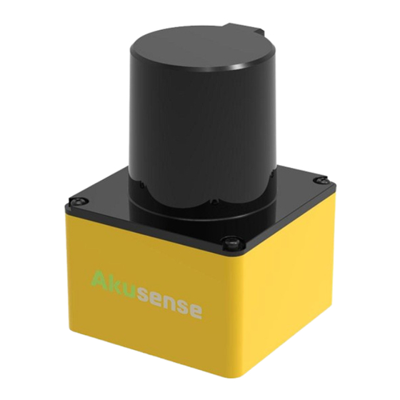
AS-31C user manual 1. Product description AS-31C is a single-line LiDAR launched by Akusense, using the pulsed time-of-flight principle (Pulsed ToF) for distance measurement. Through internal high-speed rotating mirror in lidar, the invisible infrared laser emitted by the ranging module is deflected to different angle, so as to scan and measure environmental profiles within 270°of the same horizontal plane. -
Page 4: Installation
The laser emission and reception area of AS-31C in the vertical direction is shown in Figure 1. When installing, please refer to the area marked with slashes in Figure 1 as the benchmark, and reserve at least 5 mm of vertical open space up and down to ensure that the laser emission and reception are not blocked. -
Page 5: Mounting
DC5521 female power socket (5.5 mm/2.1 mm) and an RJ45 Ethernet male connector (as shown in Figure 4). 1A (or higher) power adapter should be used to power the AS-31C. After the power is on and connected to the computer/ switch via the LAN cable,data communication with the AS- 31C can be performed. -
Page 6: Operation Instruction
User Manual of Firewall Software. 4.3 Viewing scanned image Once the AS-31C is connected to a computer and the system is properly set up, the LVS2D software can be used to view the live scanned image. The main interface of LVS2D software is... - Page 7 Main interface of LVS2D software It contains the following functional areas: Device list area, used to display all AS-31C lidars connected to the computer. LVS2D supports mDNS/DNS-SD, which can automatically detect the connected lidars and display them in the list. Users can choose to view the scanned image of specific lidar by clicking each item in the list, and the name of the selected lidar will be displayed in green bold.
-
Page 8: Dimensions
Coordinate display area is used to display the current mouse pointer, as well as the coordinate position and distance information of the current highlighted scan point. The reference coordinate system is the AS-31C device coordinate system, and all values are in meters. -
Page 9: Interface Box
AS-31C user manual 5.2 Interface box...
Need help?
Do you have a question about the AS-31C and is the answer not in the manual?
Questions and answers