Table of Contents
Advertisement
Quick Links
Precautions
Very important information. Please read this section carefully before using this product.
This product is intended to provide turn-by-turn instructions to safely guide you to your desired
destination. Please make sure that all persons using this navigation software carefully read these
precautions and the operating instructions in Nextar software manual.
Nextar cannot accept any responsibility whatsoever for accidents resulting from failure to observe
these precautions.
Your personal judgment, traffic regulations, and common sense must always take
precedence over instructions produced by the software.
This product is not a substitute for your driving technique, driving knowledge or especially
your personal judgment. Route suggestions made by this navigation system should never
supersede any traffic regulations, your personal judgment, or your knowledge of safe driving
practices. If you feel that a route suggestion made by the software instructs you to perform an
unsafe or illegal maneuver, places you in an unsafe situation, or routes you into an area that
you consider unsafe, do not follow the instructions. Your personal judgment, traffic regulations,
and common sense must always take precedence over instructions produced by the software.
When your vehicle is moving, keep your eyes on the road instead of looking at the screen. If
you need to look at the screen for a prolonged time, always park the car in a safe manner and
in accordance with all traffic regulations.
Do not select or input destinations, change settings or otherwise manually operate this soft-
ware unless you have parked your car in a safe manner, observing all traffic regulations.
If you are responding to an emergency, it may not be prudent to rely on this system unless
you have no other means to obtain accurate directions. The database does not include all of
the facilities and streets necessary for emergency response, and the system's maps may not
reflect recent changes in roads, traffic controls and driving conditions. Use your own judgment
in these situations.
The database utilized by this software is the most accurate and up-to-date database available.
Because of road closures, construction, weather, new roads and other conditions, the data-
base might not contain accurate information regarding all streets and locations. If so, the sys-
tem might not be able to correctly guide you on your route or may inaccurately estimate the
time needed to reach your destination. Please use your judgment in these cases. Renewing
your subscription to the database will aid in keeping it up-to-date.
There are situations when the navigation system will incorrectly display the vehicle's position
on the map. Usually this situation will correct itself automatically. Use your own judgment at all
times. If you need to reset the position, pull over in a safe manner observing all traffic regula-
tions.
Precautions
1
Advertisement
Table of Contents

Related Manuals for Nextar M3-RE


Summary of Contents for Nextar M3-RE
- Page 1 Please make sure that all persons using this navigation software carefully read these precautions and the operating instructions in Nextar software manual. Nextar cannot accept any responsibility whatsoever for accidents resulting from failure to observe these precautions. Your personal judgment, traffic regulations, and common sense must always take precedence over instructions produced by the software.
-
Page 2: Points To Observe For Safe Usage
Failure to follow the following instructions can result in severe injury or death. Read this manual carefully and make sure you understand the cautions. Nextar is not re- sponsible for problems resulting from failure to observe the precautions, warnings, and in structions in this manual. -
Page 3: Table Of Contents
Contents 1 — GPS Basics __________________________________________________________ Main Map Display ..4 Map Displays Modes..4 Turn-By-Turn Views ..5 Browsing the Map Display ..6 Zooming In and Out ..6 Data Entry ..7 2 — Set Destinations_________________________________________________________ 8 To Set a Destination Using an Address ... -
Page 4: Gps Basics
Nextar GPS is a full-featured GPS navigational voice guidance program that uses statistical and probability analysis to help you select and set destinations quickly and easily. As you travel, Nextar GPS displays your location on the map. Voice guidance tells you when and where to turn. The main screen displays turn directions, compass heading, distance to next maneuver, and street names. -
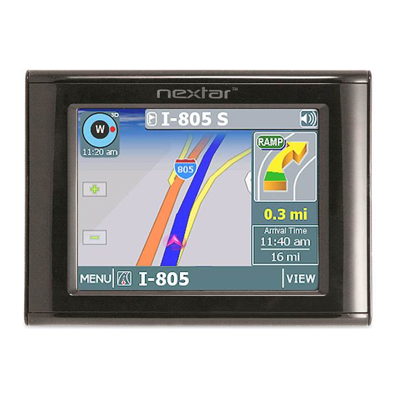
Page 5: Turn-By-Turn Views
The map displays a 3D perspective. Turn-By-Turn Views Once you set a destination and select GO, the screen displays Turn-By-Turn views. Main Turn-by-Turn View Split Map View Nextar GPS Blue line shows route. Next maneuver. Tap to repeat the voice instruction. Distance to next maneuver. -
Page 6: Browsing The Map Display
Maneuvers List View Browsing the Map Display Tap on the map to enter Browse Mode. (See below.) Tap-and-drag to scroll the map. Tap on a POI icon, and then tap “i” in lower right to view related information. To exit Browse Mode, tap the “X” in the upper right corner. Zooming In and Out Tap + or - to change the zoom level. -
Page 7: Data Entry
Nextar GPS Data Entry When you set a destination, GPS may prompt you to enter required information, such as the name of a city or the name of a street. As you enter information, the screen highlights the characters that are likely to be next. -
Page 8: Set Destinations
Use this option to go to the center of a city you choose. Follow the prompts to set a destination. GPS displays the destination location. (See below.) Choose GO. Voice instructions will guide you to your destination while the screen displays your present location and Turn-By-Turn information. -
Page 9: To Set A Destination Using A Point Of Interest
Use this option to go to a point of interest near your current location. Use this option to go to a point of interest near your destination. Follow the prompts to set a destination. Once you set a destination, GPS displays the destination location on the map. (See below.) Choose GO. -
Page 10: To Set A Destination Using Cross Roads
Use this option to go to an address in a city you choose. Use this option to go to an address in a region you choose. Follow the prompts to set a destination. Once you set a destination, GPS displays the destination location on the map. (See below.) Choose GO. -
Page 11: To Set A Destination Using An Item In Favorites
Use this option to set a location or destination as Home. Use this option to rename a location in the Favorites list. Use this option to delete a location in the Favorites list. To Cancel a Route Choose: > Nextar GPS >... -
Page 12: To Save A Destination As A Favorite Or Home Location
To Save a Destination as a Favorite or Home Location Set a destination, and then choose: Next: —Or— Browse to the desired location on the map, and then choose: > —Or— Choose: > Select an item in the list, and then choose: 2 —... -
Page 13: Program Settings
3 — Program Settings > Tap to select options, and then tap OK. > Tap to select an option, and then tap OK. > Use this option to set a starting point that is different than the current GPS position. -
Page 14: Route Settings
Route Settings > > Demo Mode > > Exit > > GPS Status > > About GPS > > Tap to select an option, and then tap OK. Use this mode to preview a route. -
Page 15: Icons And Controls
4 — Icons and Controls Compass and GPS Icon Name Heading-Up North-Up Compass User Interface Controls and Icons Control or Icon Name Current Vehicle Position and Heading Icon Browse Mode Cursor Browse Mode indicator Current Street / Next Cross Street Toggle... - Page 16 Keys Scroll Buttons OK Button VIEW Options Button GO / SAVE & GO Nextar GPS Description Deletes characters like a Backspace key. Tap to return to the main map display. Displays the next valid characters only. The highlighted characters represent the three most likely characters.
-
Page 17: Turn-By-Turn Icons
Control or Icon Name Route Calculation Crite- ria button SET ORIGIN POI Icons Green Flag Checkered Flag Turn-By-Turn Icons Control 4 — Icons and Controls Description Tap to cycle through the route calculation criteria options. Tap to set the current location as the starting vehicle posi- tion. - Page 18 Nextar GPS Control Description The name of the street on which you will be turning next ap- pears at the top of the display. The background color changes from grey to red as you approach the intersection to make the next maneuver.
- Page 19 Nextar, Inc. Any unauthorized distribution of this manual is expressly forbidden. Nextar may find it necessary to modify, amend, otherwise change, or update this manual. We reserve the right to do this at any time, without any prior notice. All specifications and features are subject to change without notice.
Need help?
Do you have a question about the M3-RE and is the answer not in the manual?
Questions and answers