Table of Contents
Advertisement
Quick Links
PYXIS GPS
model tracker
Quick Reference Guide V1.5
© ffelectronics – August 2022
Introduction
The PYXIS tracker is a free-flight model aircraft recovery system based on the Global Navigation
Satellite System (GNSS), which uses multiple satellite networks such as GPS, GLONASS, Galileo,
Beidou and other regional systems. It does not require the user to transmit any data, operates
independently of any telephone or Internet reception, and works anywhere on earth where there
is free line of sight to four or more satellites.
The PYXIS tracker consists of a receiver (handheld unit) and a beacon (transmitter installed on the
model). Each unit has its own GNSS module which makes it aware of its position. A long-range
radio link allows the transmission of the model's position to the hand unit which, in combination
with the data from a local electronic compass, displays the distance and the bearing in a straight
line to the model, whatever the path taken for the approach.
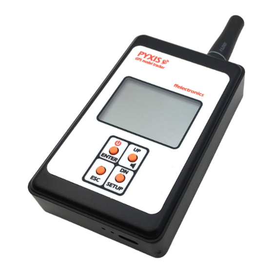
PYXIS Receiver
Advertisement
Table of Contents

Related Manuals for ffelectronics PYXIS GPS

Summary of Contents for ffelectronics PYXIS GPS
- Page 1 PYXIS GPS model tracker Quick Reference Guide V1.5 © ffelectronics – August 2022 Introduction The PYXIS tracker is a free-flight model aircraft recovery system based on the Global Navigation Satellite System (GNSS), which uses multiple satellite networks such as GPS, GLONASS, Galileo, Beidou and other regional systems.
- Page 2 Switching the receiver ON/OFF Press and hold the button (2 seconds approx.) to switch the receiver ON/OFF Handheld unit LCD model direction north direction disabled radio signal from model buzzer status enabled position local GPS status OK - updated model GPS status model on the ground unknown (flashing)
- Page 3 PYXIS Beacon Positioning Position the beacon with the radio antenna wire vertical out of the top of the pylon. If the pylon is made of conductive material (e.g. carbon), the narrower upper part of the beacon (approximately 4.5mm high) should protrude completely from the top of the pylon outline. Bottom side LED indications The green and red LEDs visible on the bottom side of the beacon provide various indications.
- Page 4 If no position updates from the beacon are received (beacon not powered, discharged battery or searching the GPS signal), the model GPS icon will be displayed as follows: • solid with an exclamation mark next to it ʘ that means that the handheld unit is pointing in an outdated position (the latest position received from the same beacon) •...
- Page 5 SYSTEM SETTINGS - MENU ITEMS Press and hold SETUP to enter the setup menu. The following describes each available menu item. LRN BEACON ID menu (learn beacon ID) Each beacon is manufactured with a 4-digit unique identifier (beacon ID). This menu allows to bind a new beacon to the handheld unit receiver.
- Page 6 DEL BEACON ID menu (delete beacon ID) This menu deletes all stored beacon IDs. • Enter SETUP > DEL BEACON ID • Confirm with <YES> if all the stored beacon IDs must be deleted or <NO> if they must be kept TRACKING menu This entry opens the tracking submenu (default menu automatically entered at power up)
- Page 7 SYSTEM BATTERIES DURATION Receiver built-in battery (1000mAh 1C) > 20 hours continuously Beacon battery (170mAh 20C) > 30-36 hours (estimated) PYXIS beacon power supply requirements The Pyxis beacon can be powered with an external power source (e-timer output, shared LiPo etc.) use the supplied red-black soft silicone pigtail.
Need help?
Do you have a question about the PYXIS GPS and is the answer not in the manual?
Questions and answers