Table of Contents
Advertisement
Quick Links
PYXIS GPS
model tracker
Quick Reference Guide V1.2
© ffelectronics – Sep 2017
Introduction
The PYXIS tracker is a free flight model retrieval system based on the Global Navigation Satellite
System (GNSS), that uses multiple satellite networks like GPS, GLONASS, Galileo, Beidou and other
regional systems. It does not require the user to transmit any data, operates independently on any
telephonic or internet reception and works anywhere on the Earth where there is an unobstructed
line of sight to four or more satellites.
The PYXIS tracker is made up of a receiver (hand-unit) and a beacon (transmitter installed on the
model). Each unit has its own GNSS module that makes it aware of its location. A long-range radio
link allows the transmission of the model position to the hand-unit, that in combination with the
data from a local electronic compass, displays the distance and the heading in a straight line to the
model, whatever the route followed to approach it.
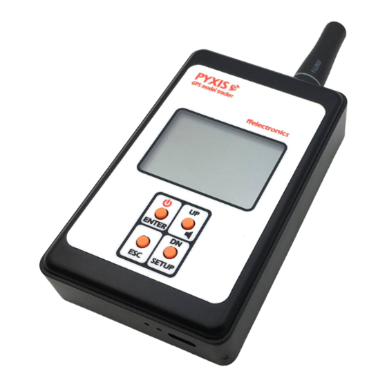
PYXIS Receiver
Advertisement
Table of Contents

Related Manuals for ffelectronics PYXIS GPS

Summary of Contents for ffelectronics PYXIS GPS
- Page 1 PYXIS GPS model tracker Quick Reference Guide V1.2 © ffelectronics – Sep 2017 Introduction The PYXIS tracker is a free flight model retrieval system based on the Global Navigation Satellite System (GNSS), that uses multiple satellite networks like GPS, GLONASS, Galileo, Beidou and other regional systems.
- Page 2 Switching the receiver ON/OFF Press and hold the button (2 seconds approx) to switch the receiver ON/OFF Displayed icons direction to model buzzer status radio signal from model position local position model position unknown beacon ID (flashing) old/outdated Unknown distance to model (flashing) Multifunction keyboard operation Press and hold SETUP to enter the setup menu.
- Page 3 at longer time intervals. The beacon is capable to wake up if the model is moved or lift, acquire the new position and resume its cyclic transmission. OPERATE THE SYSTEM How model tracking works With the model flying, the beacon transmits a position update every 10 seconds, the radio signal from the beacon to the receiver has no obstacles and the range is very long.
- Page 4 SYSTEM SETTINGS - MENU ITEMS Press and hold SETUP to enter the setup menu. The following describes each available menu item. Learn Beacon Id Each beacon is manufactured with a unique identifier (beacon ID). This menu allows to bind a new beacon to the receiver.
- Page 5 Direction Adjustment This menu allows a fine adjustment of the arrow direction to compensate for magnetic declination (difference between true North and magnetic North in different places of the Earth). Usually this adjustment is not needed, as the direction error decreases with the distance from the beacon. •...
Need help?
Do you have a question about the PYXIS GPS and is the answer not in the manual?
Questions and answers