Table of Contents
Advertisement
Advertisement
Table of Contents

Related Manuals for AllyNav Geodetic R26


Summary of Contents for AllyNav Geodetic R26
- Page 1 SHANGHAI ALLYNAV TECHNOLOGY CO., LTD. Geodetic GNSS Receiver R26 User Manual...
-
Page 2: Table Of Contents
SHANGHAI ALLYNAV TECHNOLOGY CO., LTD. Contents Geodetic GNSS Receiver ......................1 R26 User Manual .......................... 1 Disclaimer ............................2 User Notice ............................3 Foreword ............................4 Company Profile ..........................5 1.Product Description........................6 2. Technical Parameter ........................7 3. Appearance introduction ......................10 3.1 Appearance of R26 product .................... -
Page 3: Disclaimer
The Company disclaims all responsibilities other than those stated in the terms and conditions of sale of its products. Shanghai Allynav Technology Co.,Ltd. makes no warranties, express or implied, for the sale and use of its products, including suitability for a particular purpose, merchantability, or liability for infringement of any patent,copyright or other intellectual property rights. -
Page 4: User Notice
SHANGHAI ALLYNAV TECHNOLOGY CO., LTD. User Notice 1.Before using this product, please read all the user information provided with the product carefully to understand the use method and precautions of this product. 2.During the outdoor installation of the geodesic GNSS receiver, the R26 receiver and related accessories should be properly waterproofed for a long time. -
Page 5: Foreword
Welcome to the geodetic GNSS receiver. This manual mainly describes how to use the geodetic GNSS receiver in detail. Technical Support: From the date of purchasing Shanghai Allynav Technology Co.,Ltd. products, users will enjoy the technical services and upgrade policies provided by Shanghai Allynav Technology Co.,Ltd. for a long time. -
Page 6: Company Profile
SHANGHAI ALLYNAV TECHNOLOGY CO., LTD. Company Profile Shanghai Allynav Technology Co.,Ltd. is a high-tech enterprise integrating R&D, production, sales and service. Based on Beidou satellite navigation, it expands Beidou industry applications and is committed to providing customers with all-round and multi-field Beidou high-precision navigation and positioning. -
Page 7: Product Description
Survey and Mapping Standard Edition Instruction Manual 1.Product Description Shanghai Allynav Technology Co.,Ltd. is a high-precision RTK product mainly used in precision agriculture, construction machinery industry, RTK measurement industry to receive satellite signals and determine ground space position . The device consists of a large-capacity battery, inertial navigation module, GNSS antenna, satellite positioning module, Bluetooth, radio module, and storage module. -
Page 8: Technical Parameter
Survey and Mapping Standard Edition Instruction Manual (6) The base station and the mobile station can be interchanged, and the equipment can be used as both a base station and a mobile station for surveying and mapping; (7) Built-in 8G large-capacity memory card, which can store important job data in real time;... - Page 9 Survey and Mapping Standard Edition Instruction Manual Cold start time: <45s Hot start time: <30s Recapture: <1s Physical Properties Working temperature: -20℃~+60℃ Storage temperature: -25℃~+60℃ Physical size: 136mm X136mmX147mm Weight: 1.16kg Shock and Vibration: 2m drop resistance Indication: 4 LED power indicator Buttons: 2 buttons Electrical Parameters Power consumption: ≤4.0W/10.5W...
- Page 10 Survey and Mapping Standard Edition Instruction Manual Configuration List R26 Radio Deluxe Edition name model quantity unit Remark Radio inertial R26 receiver navigation Single version 12V power adapter 12V / 3A Single Rod antenna QT450GT piece Nine core aerial plug Short piece download setting line...
-
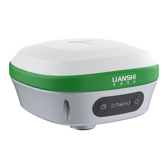
Page 11: Appearance Introduction
Survey and Mapping Standard Edition Instruction Manual 3. Appearance introduction 3.1 Appearance of R26 product 3.2 R26 function indication 3.2.1 Interface function R26 receiver interface Contains a nine-core aerial plug and a TNC interface. The definition of the connector is as follows: POW/COM: used for receiver charging and data exchange between the board and the receiver backplane;... - Page 12 Survey and Mapping Standard Edition Instruction Manual 3.2.2 Panel function R26 receiver panel indicator unit Contains four indicators and two buttons. Indicator light: Press and hold the power button for 2 seconds to turn on the power. After turning on the power, the 4 lights flash once, and then the POW light is always on, which means the boot is successful.
-
Page 13: Working Mode Configuration Instructions
Survey and Mapping Standard Edition Instruction Manual 4.Working Mode Configuration Instructions R26 baseboard firmware R2X M_V1.0.5 presets 6 working modes and 2 control states. LS-GNSS-R2X M_V1.0.6 (firmware version) ID:R26 (device model) PN: 312605801090767 (device PN code) SN:1121112088 (device SN code) COM1 38400bps (external CONFIG debug port baud rate) COM2 115200bps (internal GNSS port baud rate) COM3 115200bps (internal IMU port baud rate) -
Page 14: Parameter Configuration And Firmware Upgrade
Survey and Mapping Standard Edition Instruction Manual 5.Parameter configuration and firmware upgrade 5.1 Parameter configuration Motherboard: Built-in UM482 board, which can be configured through the instructions of the UM4B0 board. Factory default baud rate: COM1 38400/COM2 115200/COM3 115200 Bottom plate: It can be configured separately by commands common to the chassis and commands for each module. -
Page 15: Precautions For Use
Survey and Mapping Standard Edition Instruction Manual 6. Precautions for use 1. The receiver GNSS antenna must be installed in an outdoor open air environment (to avoid blocking), otherwise the device will not work properly. 2. The power supply voltage of the receiver must be 7~35VDC. 3. -
Page 16: After-Sales Service
Survey and Mapping Standard Edition Instruction Manual 7. After-sales service From the date of purchasing Lianshi's products, users will enjoy the technical services and upgrade policies provided by Shanghai Allynav Technology Co.,Ltd. for a long time. Company technical service hotline: 021-61200180... - Page 17 Survey and Mapping Standard Edition Instruction Manual —Increase the separation between the equipment and receiver. —Connect the equipment into an outlet on a circuit different from that to which the receiver is con nected. —Consult the dealer or an experienced radio/TV technician for help.
Need help?
Do you have a question about the Geodetic R26 and is the answer not in the manual?
Questions and answers