Furuno CI-68 Operator's Manual
Doppler sonar current indicator
Hide thumbs
Also See for CI-68:
- Brochure & specs (2 pages) ,
- Installation manual (75 pages) ,
- Operator's manual (64 pages)
Table of Contents
Advertisement
Quick Links
Advertisement
Table of Contents
Troubleshooting

Related Manuals for Furuno CI-68


Summary of Contents for Furuno CI-68
- Page 1 DOPPLER SONAR CURRENT INDICATOR CI-68...
- Page 2 Printed in Japan Printed in Japan All rights reserved. All rights reserved. PUB.No. OME-72520 PUB.No. OME-72520 ( ( DAMI DAMI ) ) CI-68 CI-68 Your Local Agent/Dealer Your Local Agent/Dealer FIRST EDITION : FIRST EDITION : OCT. OCT. 2003 2003 : : NOV.
- Page 3 Continued use of the equipment can cause fire or electrical shock. Contact a FURUNO agent for service. Do not disassemble or modify the equipment. Fire, electrical shock or serious injury can result.
- Page 4 WARNING LABEL A warning label is attached to the transceiver and monitor units. Do not remove the labels. If a label is missing or damaged, contact a FURUNO agent or dealer about replacement. Transceiver Unit WARNING Name: Warning Label (1)
-
Page 5: Table Of Contents
TABLE OF CONTENTS FOREWORD ...v SYSTEM CONFIGURATION ...vi DISPLAY EXAMPLE ...vii 1. OPERATIONAL OVERVIEW... 1-1 1.1 Controls... 1-1 1.2 Turning the Power On/Off... 1-2 1.3 Adjusting LCD Brilliance ... 1-3 1.4 Choosing a Display... 1-4 1.4.1 Tide vector display ... 1-4 1.4.2 Ship’s speed display ... - Page 6 4. MAINTENANCE & TROUBLESHOOTING ... 4-1 4.1 Routine Maintenance... 4-1 4.2 Replacing Fuses ... 4-2 4.3 Troubleshooting ... 4-3 4.4 Diagnostics ... 4-4 4.4.1 General test... 4-4 4.4.2 Panel test ... 4-6 4.4.3 Test pattern ... 4-7 4.5 Error Messages and Alerts ... 4-8 APPENDIX ...AP-1 MENU TREE...
-
Page 7: Foreword
FOREWORD A Word to the Owner of the CI-68 Congratulations on your choice of the FURUNO CI-68 Doppler Sonar Current Indicator. We are confident you will see why FURUNO has become synonymous with quality and reliability. For over 50 years FURUNO Electric Company has enjoyed an enviable reputation for innovative and dependable marine electronics equipment. -
Page 8: System Configuration
SYSTEM CONFIGURATION MONITOR UNIT MU-100C CONTROL UNIT CI-6888 System configuration CONTROL UNIT CI-6888 : Standard Supply : Optional Supply : Local Supply... -
Page 9: Display Example
DISPLAY EXAMPLE Object and color Tide of layer 1: Yellow Tide of layer 2: Purple Tide of layer 3: Light-blue Own ship speed vector: Green Heading line: White (dashed) Tide vector display... -
Page 11: Operational Overview
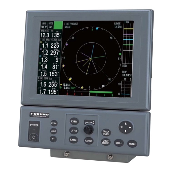
OPERATIONAL OVERVIEW 1.1 Controls FURUNO Control POWER Turns power on or off. F1 – F3 Function keys (menu shortcut keys) LYR1 – LYR3 Set tide measuring depths for respective layers. Setting Knob Sets measuring depth and range. RANGE Sets range. The range which can be set depends on mode. -
Page 12: Turning The Power On/Off
The equipment conducts the diagnostic test to check for proper operation between the transceiver unit and the control unit and displays the results. After the diagnostic test is completed the last-used display appears. CI-68 CI-6888 VOL. 6651000-XX.XX MEM. 1 CI-6810 VOL. -
Page 13: Adjusting Lcd Brilliance
1.3 Adjusting LCD Brilliance You can adjust the brilliance of the FURUNO-supplied monitor as below. To adjust the brilliance of a commercial monitor, see its owner’s manual. 1. Press the [BRILL] key to open the brilliance adjustment window. Note: Execute the next step within five seconds after displaying the brilliance adjustment window. -
Page 14: Choosing A Display
1. OPERATIONAL OVERVIEW 1.4 Choosing a Display This current indicator has six main displays: tide vector display, ship’s speed display, course plot display, text display, echo level display and graph display. You may choose a display by pressing the [DISP MODE] key. 1.4.1 Tide vector display The tide vector display mainly shows tide speed and direction for three layers with a vector. -
Page 15: Ship's Speed Display
1. OPERATIONAL OVERVIEW 1.4.2 Ship’s speed display The ship’s speed display shows ship’s fore-aft and port-starboard speeds in analog and digital form. Synthesized Speed Vector (Green) Ship’s speed display 1.4.3 Graph display The graph display plots water temperature and depth data in graph form. Graph display... -
Page 16: Course Plot Display
1. OPERATIONAL OVERVIEW 1.4.4 Course plot display The course plot display plots ship’s track along with tide vectors. Course plot display 1.4.5 Text display The text display provides various nav data in digital format. Text display... -
Page 17: Echo Level Display
1. OPERATIONAL OVERVIEW 1.4.6 Echo level display The echo level display shows the strength of the echoes captured by three sounding beams. Note that ECHO LEVEL in the MODE menu must be set to ON to show the echo level display. -
Page 18: Setting Measuring Depths
1. OPERATIONAL OVERVIEW 1.5 Setting Measuring Depths Set the depths at which you wish to measure tide speed and direction as below. Note that layer 3 cannot be set when BTM TIDE TRACK in the MENU 1 menu is set to ON. 1. -
Page 19: Choosing Speed Tracking Mode
1.6 Choosing Speed Tracking Mode The tracking mode is available in ground tracking, water tracking, NAV and automatic. Ground tracking: Absolute ship and tide movements based on ground and current (tide display (bottom echo must be present). Water tracking: Ship and tide movements relative to near-surface water and tide differential between tide layers. -
Page 20: Choosing The Range
1. OPERATIONAL OVERVIEW 1.7 Choosing the Range You may choose the speed range as follows: 1. Press the [RANGE] key to show the range setting window. Range setting window (example: range setting window for tide vector display) 2. Within five seconds after completing step 1, operate the Setting Knob or the CursorPad to set the range. -
Page 21: Interpreting The Displays
INTERPRETING THE DISPLAYS 2.1 Tide Vector Display Note: Tide vector display... - Page 22 2. INTERPRETING THE DISPLAYS Description of indications on tide vector display Item Heading Ship’s heading fed from a heading sensor. Mode Shows current tracking mode, as selected with the [TRACK MODE] key. Mode marker Shows tracking mode and echo availability for last three minutes, scrolling from right to left.
- Page 23 Item Tide speed and direction is shown for three layers (measuring depths). The Tide speed and displayable range is 0.0 to 9.9 kts for speed and 0° to 359° for course. Data direction shown depends on the measuring mode as follows: Ground tracking mode: Speed and direction values of measuring layers represent movement of layer relative to ground.
- Page 24 2. INTERPRETING THE DISPLAYS Item Heading line The heading line is a dashed line which shows ship’s heading. It extends from ship’s position (center of vector display) to the edge of the vector display. The line can be turned on or off with HEADING LINE in the DISP1 menu. Tide/tide Tide vectors may be turned on or off with LAYER 1, LAYER 2 and LAYER 3 in differential vector...
-
Page 25: Ship's Speed Display
2.2 Ship’s Speed Display Description of ship’s speed display indications Item Ship’s speed* (In Port-starboard and fore-aft speeds are synchronized when SCALE SYNC in GT, WT) or the DISP2 menu is set to ON. The available speed setting range is 0.0 to 30.0 Water tracking (kt). - Page 26 2. INTERPRETING THE DISPLAYS Description of ship’s speed display indications (con’t from previous page) Item Own ship vector* Fore-aft speed history graph Port-starboard history graph *: Speed used for calculation depends on setting of SHIP SPD MODE in the DISP1 menu. GT/WT: Speed is calculated according to tracking mode, ground speed for ground tracking mode and water speed for water tracking mode.
-
Page 27: Graph Display
2.3 Graph Display Description of graph display indications Item Text window Tide (or tide differential, speed) graph Note: Graph display Description The text window may be turned on or off with TEXT WINDOW in the DISP1 menu. When the text window is turned off, 12 hours of graph data are shown. - Page 28 2. INTERPRETING THE DISPLAYS Description of graph display indications (con’t from previous page) Item Water temperature graph The water temperature graph may be turned on or off with TEMP GRAPH in the DISP1 menu. Mode marker The mode marker shows by color which tracking mode is in use. Green: Blue: Background: Ship’s speed error...
-
Page 29: Course Plot Display
2.4 Course Plot Display Description of course plot display indications Item Text window Ship’s track Tide vector North mark Scale Tide display interval Position Course plot display Description The text window can be turned on or off with TEXT WINDOW in the DISP2 menu. -
Page 30: Echo Level Display
2. INTERPRETING THE DISPLAYS 2.5 Echo Level Display Description of echo level display indications Item Echo level Echo display range 2-10 Echo level display Description Echo status of beam 1 (fore), beam 2 (starboard) and beam 3 (port) is displayed in eight colors. The echo display range can be set with ECHO RANGE in the MENU 1 menu. -
Page 31: Error Display
12.0 (1) No data is being input from the transceiver unit to the display unit. If this occurs, contact a FURUNO agent or dealer. (2) This display appears when the ground tracking echo for ground tracking, reference layer for water tracking or GPS data from the GPS navigator is abnormal. In this case data is not reliable. - Page 32 2. INTERPRETING THE DISPLAYS Tide for three layers/tide differential 2.3 140 ® 2.3 140 Tide and tide differential error displays (3) Displayed when echo for a measuring layer is not present. The readout for the offending measuring layer is not reliable. (4) Displayed when the depth setting for a measuring layer is improper.
-
Page 33: Customizing The System
CUSTOMIZING THE SYSTEM Less-often used functions are stored in the menu. There are four main menus, MENU 1, MENU 2, ALARM and INSTALLATION. The MENU 2 and INSTALLATION menus have three sub menus each. 3.1 Menu Operation 1. Press the [MENU] key to open the menu. The last-used menu appears. MODE menu 2. - Page 34 3. CUSTOMIZING THE SYSTEM 3. Press ◄ or ► to choose the main menu desired among MENU 1, MENU 2, ALARM and INSTALLATION menus. Then, the menu changes according to your selection. For the MENU 2 and INSTALLATION menus the sub menu title appears. To choose a sub menu, press ▼...
-
Page 35: Function Keys
3.2 Function Keys 3.2.1 Programming the function keys The function keys ([F1]-[F3]) provide menu shortcut operation. You may program the keys as follows: 1. Press the [MENU] key to display the main menu. 2. Choose menu desired. Note: The ALARM and INSTALLATION menus cannot be used. 3. -
Page 36: Menu 1 Menu
3. CUSTOMIZING THE SYSTEM 3.3 MENU 1 Menu This menu mainly provides items for adjustment of tide parameters. MENU 1 menu SHIP SPEED AVG Choose the averaging time for the ship’s speed display. The choices are 15, 30, 60 and 90 seconds. - Page 37 BOTTOM SEARCH BOTTOM SEARCH enables reacquisition of temporarily lost ground echo, in the water tracking mode. When the bottom echo is lost for a short while due to air bubbles, or the equipment tends to track on false bottom, acquire the bottom echo manually as follows: 1.
- Page 38 3. CUSTOMIZING THE SYSTEM ECHO RANGE Choose the maximum depth to display echoes, from among 50, 100, 150, 200, 250, 300, 350, 400, 450, 500 (m). Turn echo TVG on or off. GAIN Adjust echo level display color. The higher the digit the nearer to the strongest color (reddish brown).
-
Page 39: Menu 2 Menu
3. CUSTOMZING THE SYSTEM 3.4 MENU 2 Menu 3.4.1 MODE menu This menu mainly turns displays on or off. All displays cannot be turned off; at least one must be turned on. Any display turned off on the MODE menu is removed from selection with the [DISP MODE] key. -
Page 40: Disp1 Menu
3. CUSTOMIZING THE SYSTEM ECHO LEVEL Enable or disable the echo level display. BACKGROUND CLR Choose the background color from among black, white and blue. 3.4.2 DISP1 menu DISP1 menu TIDE RANGE Set the tide range for the tide vector display, graph display and echo level display. The choices are 0.5, 1.0, 2.0, 3.0, 5.0 and 10.0 (kts). - Page 41 DISPLAY MODE Set display orientation for head-up or north-up. Heading device required for North-up. Head-up and north-up display modes SHIP SPD MODE Choose the tracking mode to use to display drift angle, fore-aft speed and port-starboard speed on the ship’s speed and text displays. MODE Choose the item to show on the graph display, among tide, tide differential and ship’s speed.
-
Page 42: Disp2 Menu
3. CUSTOMIZING THE SYSTEM 3.4.3 DISP2 menu ECHO LEVEL Turn the echo level display on or off on the tide vector display. DISP MODE Choose how to show the echo level display. SOUNDER: Echo strength shown in eight colors. GRAPH: Echo strength shown by graph. Beam 1 Beam 3 Beam 2... - Page 43 SCALE SYNC Choose whether to interlock port-starboard speed range with fore-aft speed range or not. DRIFT SCALE Set the port-starboard speed range on the ship’s speed display. The choices are 0.5, 1.0, 2.0, 3.0, 5.0 and 10.0 (kt). Note: You may adjust DRIFT SCALE at any time, however you must turn off SCALE SYNC in the DISP2 menu for it to become active.
-
Page 44: Alarm Menu
3. CUSTOMIZING THE SYSTEM 3.5 ALARM Menu The ALARM menu sets the parameters for the tide speed and tide direction alarms, ship’s speed alarm and trip distance alarm. When an alarm setting is violated, the audible alarm sounds and a warning message (flashing) appears. To silence the audible alarm, press the CursorPad. -
Page 45: Setting/Canceling Tide Speed, Tide Direction, Tide Differential And Ship's Speed Alarms
3. CUSTOMZING THE SYSTEM 3.5.2 Setting/Canceling tide speed, tide direction, tide differential and ship’s speed alarms This section shows how to set the tide speed, tide direction, tide differential and ship speed alarms. As an example, for LAYER 1, set the tide speed alarm for 1-2 kts and tide direction alarm for 350°-10°. - Page 46 3. CUSTOMIZING THE SYSTEM Alarm setting screen (tide, ship’s speed) 6. Use ◄ or ► to set minimum speed; ▲ or ▼ to set maximum speed. As you operate an “arrow,” the radius of the inner or outer circle is increased or decreased accordingly. Your screen should now look something like the one shown below.
-
Page 47: Setting The Trip Alarm
° ° ° 11. Press any function key to return to the ALARM menu. “ in LAYER 1. When the alarm setting is violated, the audible alarm sounds and an alarm message appears. 12. Press the [MENU] key to close the menu. 3.5.3 Setting the trip alarm Trip distance alarm The trip distance alarm sounds when the vessel has traveled more than the preset distance. -
Page 48: Disabling/Enabling The Audible Alarm
3. CUSTOMIZING THE SYSTEM Trip time alarm The trip alarm sounds when the preset trip time has elapsed. 1. Press the [MENU] key to open the menu. 2. Press ▲ to place the cursor on the main menu title field. 3. -
Page 49: Maintenance & Troubleshooting
MAINTENANCE & TROUBLESHOOTING Periodic checks and maintenance are important for maintaining performance. This chapter contains maintenance and troubleshooting instructions to be followed to obtain optimum performance and the longest possible life of the equipment. Before attempting any maintenance or troubleshooting procedure, please review the safety information below. 4.1 Routine Maintenance General checks Check the following monthly. -
Page 50: Replacing Fuses
4. MAINTENANCE & TROUBLESHOOTING 4.2 Replacing Fuses The transceiver unit, monitor unit and control unit are equipped with a fuse which protects them from overvoltage and equipment fault. If a fuse blows, find the cause before replacing it. If it blows again after replacement, contact your dealer for advice. All fuses are located inside the units. -
Page 51: Troubleshooting
4.3 Troubleshooting Below are simple troubleshooting procedures which the user may follow to try to restore normal operation. If normal operation cannot be restored, do not attempt to check inside any unit. Any repair work is best left to a qualified technician. If…... -
Page 52: Diagnostics
4. MAINTENANCE & TROUBLESHOOTING 4.4 Diagnostics The current indicator is equipped with several test facilities to check it for proper operation. 4.4.1 General test The general test mainly checks the ROM, RAM and voltages. 1. Press the [MENU] key to open the menu. 2. - Page 53 6651001 ° Description of control unit test results VOL: Program version no. of the OCK Board (66P3927) MEM: Check of 1: ROM, 2: SRAM and 3: EEPROM SIO: OK if normal; NG if abnormal. Description of transceiver unit test results VOL: Program version no.
-
Page 54: Panel Test
4. MAINTENANCE & TROUBLESHOOTING 4.4.2 Panel test The panel test checks the keys and setting knob on the control unit for proper operation. 1. Open the MENU 1 menu and choose PANEL from TEST. 2. Press any function key to start the test. A screen for testing the control unit appears on the display. -
Page 55: Test Pattern
3. Press ► to change the picture in the sequence shown above. You may reverse the order by pressing ◄. Note: You may adjust the brilliance of the FURUNO-supplied monitor by operating the [BRILL] key. 4. To quit the test, press the [MENU] key to return to the MENU 1 menu. -
Page 56: Error Messages And Alerts
4. MAINTENANCE & TROUBLESHOOTING 4.5 Error Messages and Alerts The current indicator displays an error message and sounds the audible alarm when error is detected. To silence the alarm, press any arrow on the CursorPad for transceiver-related alarm or turn off the alarm in the ALARM menu in case of control unit-related alarm. In case of multiple errors, the error or alert having the highest priority is displayed. -
Page 57: Appendix
APPENDIX MENU TREE Default settings shown in bold italic. 15 sec 2 min LAYER 1 32 CMPS 150 m BLACK HEAD UP GT/WT TIDE NORTH 3.0 kt AP-1... - Page 58 MENU TREE AP-2 SOUNDER 1 kt 16 kt 1:20000 LONG ° 10.0...
-
Page 59: Tide Measurement In Nav Mode
TIDE MEASUREMENT IN NAV MODE The accuracy of tide measurement in the NAV mode depends heavily on gyrocompass accuracy. Setting ship’s heading The current indicator has a NAV mode which measures tides in deep waters where ground tracking is not available. To achieve reliable measurements, however, you must feed accurate heading (gyro) data and ship’s position (or speed and course) data to the current indicator. - Page 60 TIDE MEASUREMENT IN NAV MODE Why gyro data is important in the NAV mode If you consider the difference of tide vector calculations in the ground tracking mode and the NAV mode, you can see the importance of gyro (heading) data. Tide calculation in the ground tracking mode In the ground tracking mode, the current indicator derives tide information from the...
- Page 61 Tide calculation in NAV mode In the NAV mode, the current indicator derives tide information from the following data: (1) Ship’s speed/course fed from navigator (GPS) (nav speed = pseudo ground speed) (2) Ship’s speed/course based on target layer (water speed) (3) Bearing of ship’s bow (heading by gyro) Here, nav speed (1) is the ship’s speed vector sensed by the navigator, and the...
-
Page 62: Principle Of Operation
PRINCIPLE OF OPERATION PRINCIPLE OF OPERATION When a moving vessel emits an acoustical pulse into the water at an angle, a portion of the emitted energy is reflected from the bottom and other microscopic objects in the sound path, such as plankton or air bubbles. The frequency of the received signal is shifted from the transmitted frequency in proportion to the relative velocity between the vessel and underwater reflecting objects. - Page 63 Ship’s Speed (Here, speed is a vector value including velocity and direction.) Depending on the base of measurement, ship’s speed is expressed in two ways: Ship’s speed and course relative to bottom (fixed base) Ground tracking speed: (Absolute speed) Ship’s speed and course relative to water layer just below the Water tracking speed: (Relative speed) vessel (floating base)
- Page 64 PRINCIPLE OF OPERATION Absolute Tide = (1) – (2) Fixed Tide Differential Tide differential is a relative movement of tides at different depths, layer (A) and layer (B). To calculate tide differential, the following two data are used: 1) Ship’s speed and course based on layer (A) 2) Ship’s speed and course based on layer (B) Tide differential between two layers is, then, given as a difference of these two speed vectors.
- Page 65 Tide, Nav-tide and Tide Differential Tide (absolute tide) Absolute tide can be measured in the ground tracking mode. 10 NM (1 hour trip) Start of trip Layer A Fixed Assume that the ship and layer A are moving in the same direction, and ship’s speeds based on ground (Vg) and on layer A (Vwa) are measured as;...
- Page 66 PRINCIPLE OF OPERATION Tide differential Tide differential is a relative movement of tides at different depths. It can be measured in the ground tracking, water tracking and NAV modes. Start of trip Layer A (Moving) Layer B (Moving) 2 kt 5 kt Assuming that the ship, layer A and layer B are moving in the same direction, and ship’s speeds based on layer A (Vwa) and on layer B (Vwb) are measured as;...
- Page 67 In the water tracking mode, watermass just below the transducer (near-surface layer) is taken as the base of all measurements (virtual ground). Therefore, the ship and tide speeds in the water tracking mode are not absolute but relative to this near-surface layer. = 9 kt (Ship’s speed based on near-surface layer) Vwa = 8 kt (Ship’s speed based on layer A) Vwb = 5 kt (Ship’s speed based on layer B)
- Page 68 PRINCIPLE OF OPERATION Tide differential calculations in water tracking mode Tide speeds of layer A (C1) and layer B (C2) relative to near-surface layer (Vw) are calculated as follows: Tide differential based on layer A (speed of layer B as viewed from layer A) D1 = Vw - Vwa (Speed of layer A based on near-surface layer) D2 = Vw - Vwb (Speed of layer B based on near-surface layer) The tide differential (Dd) between layers A and layer B is;...
-
Page 69: Specifications
SPECIFICATIONS OF CI-68 TIDE Speed Accuracy Direction No. of measuring layers 3 Range of measurement 2-150 m SPEED Speed Accuracy Direction Depth of measurement (ground tracking mode) underwater conditions.) DISPLAY Display TRANSMISSION Frequency FUNCTIONS Modes of measurement Ground tracking, water tracking, nav-aided, automatic... - Page 70 10.2 Control unit 10.3 Transceiver unit Current loop, NMEA 0183 ver. 1.5/2/0/3.0, IEC 61162-1 Ed. 2 IEC 61162-2, current indicator (FURUNO’s own format) ZDA, RMC, RMA, GGA, GLL, VTG, HDT, HDM, HDG, DBT, DPT, System time, measuring position, heading, bearing, depth, water...
-
Page 71: Index
INDEX ALARM menu ...3-12 Alarms disabling audible alarm...3-16 disabling/enabling...3-16 ship’s speed...3-13 tide differential ...3-13 tide speed and direction ...3-13 trip alarm (distance)...3-15 trip alarm (time) ...3-16 Background color...3-8 Bearing mode ...3-4 Bottom search ...3-5 Bottom tide tracking...3-5 BRILL key ...1-3 Brilliance ...1-3 Control description...1-1 Course plot display... - Page 72 INDEX Panel dimmer ...3-6 Panel test...4-6 POWER switch ...1-2 RANGE key ...1-10 Scale...2-19, 3-11 Scale sync ...3-11 Ship speed display on/off ...3-7 Ship’s speed averaging ...3-4 Ship’s speed display description ...2-15 overview...1-5 Ship’s speed mode ...3-9 Ship’s speed vector on/off ...3-8 Ship’s track on/off ...3-11 IN-2 Test pattern ...
Need help?
Do you have a question about the CI-68 and is the answer not in the manual?
Questions and answers