Table of Contents
Advertisement
L76X GPS HAT User Manual
OVERVIEW
This is a Raspberry Pi GNSS HAT which supports Multi-GNSS systems: GPS, BDS, and QZSS, with
advantages such as fast positioning, high accuracy, low power consumption, and so on.
It is an easy way to enable global positioning function for your Raspberry Pi.
FEATURES
⚫
Supports Multi-GNSS systems: GPS, BDS, and QZSS
⚫
EASY™, self track prediction technology, help quick positioning
⚫
AlwaysLocate™, intelligent controller of periodic mode for power saving
⚫
Supports DGPS, SBAS (WAAS/EGNOS/MSAS/GAGAN)
⚫
UART communication baudrate: 4800~115200bps (9600bps by default)
⚫
Onboard battery holder, supports ML1220 rechargeable battery, for preserving ephemeris
information and hot starts
⚫
4x LEDs for indicating the module working status
⚫
Comes with development resources and manual (examples for Raspberry Pi/Arduino/STM32)
SPCIFICATIONS
GPS SPECIFICIATIONS
⚫
Band: GPS L1(1575.42Mhz), BD2 B1 (1561.098MHz)
◼
Channels: 33 tracking ch, 99 acquisition ch, 210 PRN ch
◼
C/A code
◼
SBA: WAAS, EGNOS, MSAS, GAGAN
⚫
Horizontal position accuracy:
◼
Autonomous: <2.5mCEP
⚫
Time-To-First-Fix @-130dBm (EASY™ enabled):
◼
Cold starts: <15s
◼
Warm starts: <5s
◼
Hot starts: <1s
⚫
Sensitivity:
◼
Acquisition: -148dBm
◼
Tracking: -163dBm
◼
Re-acquisition: -160dBm
L76X GPS HAT
User Manual
1 / 15
Advertisement
Table of Contents

Summary of Contents for Waveshare L76X GPS HAT
-
Page 1: Overview
L76X GPS HAT User Manual L76X GPS HAT User Manual OVERVIEW This is a Raspberry Pi GNSS HAT which supports Multi-GNSS systems: GPS, BDS, and QZSS, with advantages such as fast positioning, high accuracy, low power consumption, and so on. -
Page 2: General Specifications
L76X GPS HAT User Manual ⚫ Dynamic performance: ◼ Altitude (max): 18000m ◼ Velocity (max): 515m/s ◼ Acceleration (max): 4G GENERAL SPECIFICATIONS ⚫ Communication interface: UART ⚫ Baudrate: 4800~115200bps (9600bps by default) ⚫ Update rate: 1Hz (default), 10Hz (max) ⚫... -
Page 3: Table Of Contents
L76X GPS HAT User Manual CONTENT Overview .............................. 1 Features ............................1 Spcifications ..........................1 GPS Specificiations ........................ 1 General Specifications ......................2 Hardware.............................. 4 Testing in PC ............................6 Hardware connection........................6 Demo codes ............................8 Download Demo code ........................8 Arduino examples ......................... -
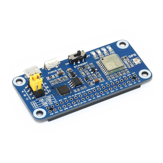
Page 4: Hardware
L76X GPS HAT User Manual HARDWARE L76B module USB TO UART port CP2102: USB TO UART converter 10. GNSS antenna connector CAT24C32: EEPROM 11. Battery holder: supports ML1220 rechargeable battery, for preserving RT9193-33: power manager ephemeris information and hot starts Backup mode wakeup button 12. - Page 5 L76X GPS HAT User Manual Backup mode: FORCE ON button is used to exit Backup mode. Relate to Standby mode, the consumption of Backup mode is lower. In this mode, module stop searching satellite. UART1 is inaccessible, only the backup memory (GPS messages and several user variables used for quick start) in RTC area works.
-
Page 6: Testing In Pc
2. Connect GPS antenna. Wire A by yellow jumpers. Turn the STANDBY switch to OFF. 3. Connect L76X GPS HAT to PC by USB cable, then the PWR indicator lights on 4. Waiting for about 1s. TXD LED become to flash, which mean that data is transmitting 5. - Page 7 Receiver menu, choose Port, and select the correct com port (refer to Devices Manager). Set baud rate: 9600 then click button to connect L76X GPS HAT. U-center display information after connecting. 7. If you want to check the area better, you can install GoogleEarthPluginSetup.exe tool, which allow you to choose Google Earth under View menu 【Note】The result you get from Google Earth maybe different with actual area because of...
-
Page 8: Demo Codes
L76X GPS HAT User Manual DEMO CODES DOWNLOAD DEMO CODE Find the product in Waveshare website, open the wiki and download demo code from wiki. Unzip: Arduino: Arduino examples based on Arduino UNO Raspberry Pi: Raspberry Pi examples include wiringpi and python codes... -
Page 9: Expected Result
L76X GPS HAT User Manual Connect L76X GPS HAT to UNO PLUS by Dupont lines, short B by yellow jumpers L76X GPS HAT Arduino EXPECTED RESULT It requires about 35s to locate (first time). Open serial monitor and set baud rate to 9600. Data printed first is original data. -
Page 10: Copy Examples
L76X GPS HAT User Manual Plug L76X GPS HAT to Raspberry Pi, short B by yellow jumpers COPY EXAMPLES Insert SD card (which has installed Raspbian image) to PC by card reader Copy Raspberry Pi examples ( the folder we download and unzip above) to BOOT directory of SD card Exit and insert the card to Raspberry Pi, then start. -
Page 11: Enable Serial Port
L76X GPS HAT User Manual sudo pip install spidev sudo apt-get install python-imaging sudo apt-get install python-smbus sudo apt-get install python-serial ENABLE SERIAL PORT UART interface should be used for communicating, so we need to enable hardware serial of Raspberry... -
Page 12: Running Codes
L76X GPS HAT User Manual Install minicom: sudo apt-get install minicom Using minicom: minicom -D /dev/ttyS0 -b 9600 【Note】If you use Raspberry Pi zero, the serial port should be ttyAMA0, you can confirm the port by command: ls -l /dev/serial0... -
Page 13: Stm32 Example
Enter to wake it up. 【Note】Even the default baud rate of L76X GPS HAT is 9600, it is changed to 115200 in code. If you find that 9600 cannot work next time, please check if it is changed. -
Page 14: Expected Result
L76X GPS HAT User Manual Wire L76X GPS HAT to STM32 board, short B by yellow jumpers. And connect USB to UART (USART1) interface of STM32 board to PC L76X GPS HAT STM32 PA10 EXPECTED RESULT Open serial assistant software in PC, set baud rate to 115200 Data printed first is original data. -
Page 15: Faq
4. Why the locating result is different with smart phone? - L76X GPS HAT use satellite locating. Smart phone use AGPS, LBS, WIFI and Bluetooth locating as well except satellite. Smart phone locate much faster. And the multi-satellite system used by smart phone are different with L76X’s...
Need help?
Do you have a question about the L76X GPS HAT and is the answer not in the manual?
Questions and answers