
Subscribe to Our Youtube Channel
Related Manuals for Xinuo XF-1069GF

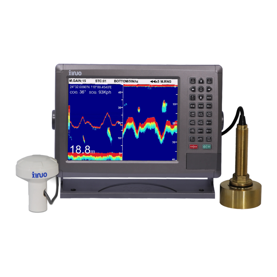
Summary of Contents for Xinuo XF-1069GF
- Page 1 GPS & Chart Plotter & Echo Sounder ◆ XF-1069GF OPERATION MANUAL ©1996-2017. Xinuo information technology (xiamen) Corporation limited...
-
Page 2: Table Of Contents
GPS Chart Plotter & Echo Sounder Contents Contents................................. 1 1-1 Introduction............................. 7 1-1-1 Appearance of the Product....................... 7 1-1-2 Packing List..........................7 1-1-3 Installation of GPS Antenna......................7 1-1-4 Getting Started..........................7 1-1-5 Keyboard Instruction........................8 2-1 System Overview..........................12 2-1-1 Main Page..........................12 2-1-2 Page Scene..........................13 2-2 Chart Operation............................14 2-2-1 Move Chart..........................14... - Page 3 GPS Chart Plotter & Echo Sounder 2-8-3 Delete Route..........................20 2-8-4 Call Route..........................20 2-8-5 Select Waypoint of the Route....................20 2-9 Accessory.............................. 20 2-9-1 Tide............................. 20 2-9-2 View Chart..........................20 2-9-3 Calendar............................ 20 2-9-4 Distance Measure........................21 2-10 MOB..............................21 2-11 Draw Line............................21 2-11-1 Add Draw Line on the Chart....................
- Page 4 4-1-17 Echo Signal Level........................41 4-1-18 Noise Reduction........................42 4-1-19 Auto Gain Correction......................42 4-1-20 A-Scope........................... 42 4-1-21 Sonic Speed Set........................43 4-1-22 Draft Set..........................43 4-1-23 Fish Finder Simulation......................44 Appendix 1: XF-1069GF Installation Overall Dimensions..............45 Appendix 2: XF-1069GF Wiring Diagram....................46...
- Page 5 Instructions: All rights reserved. Information in this manual is subject to update without notice. XINUO reserves the right to change or update the contents without obligation to notify any person or organizations. You can visit the XINUO web site: www.xinuo.com to know the latest updated information and operation of this or other XINUO products.
- Page 6 11. Virtually, all data sources might contain some inaccurate or incomplete data. The data is only for your reference and we cannot guarantee any accident, injury or proper damage. All legal responsibility and other obligation will not be taken by XINUO.
- Page 7 GPS Chart Plotter & Echo Sounder OVERVIEW This chapter generally introduces the appearance of the product and the button functions on the keyboard.
-
Page 8: Introduction
1-1 Introduction 1-1-1 Appearance of the Product XF-1069GF are 10.4 inch GPS Chart Plotter with 800*600TFT pixels resolution. They are all suitable for table installation, flush mounting and ceiling installation. They can be connected with other related auxiliary equipment, and the display can be adjusted to the best angle of view. -
Page 9: Keyboard Instruction
GPS Chart Plotter & Echo Sounder 1-1-5 Keyboard Instruction Key Name Description 〖Zoom in/Range↑〗 1】Map:map show of detailed information 2】Fish Finder:reduce range scope 〖Zoom out /Range↓〗 1】Map:show of global information 2】Fish Finder:increase range scope 〖Arrow Keys〗 1】Map:button select,cursor move ←↑→↓ 2】Fish Finder:Adjust the value of depth\ sub-range\sub-shift by↑↓. - Page 10 GPS Chart Plotter & Echo Sounder Key Name Description 〖Menu〗 1】 Map:press once to【Main menu】,Press twice to 【parameters setting】 2】 Fish Finder:Popup【Fish Finder】 〖Cancel〗 Cancel option or exit menu. Hide cursor and move map by 〖 Arrow Keys 〗 on map, show cursor by press〖Cancel〗again.
- Page 11 GPS Chart Plotter & Echo Sounder Key Name Description 2】 Fish Finder:adjust sub-range by arrow keys↑↓. Note:Sub-range is available in zoom in map , zoom in sea bed and B.D. 〖GOTO/Depth〗 1】 Map:To call navigation data. It can call the Forward Navi and Reverse Navi of waypoint, route, etc.
- Page 12 GPS Chart Plotter & Echo Sounder INTRODUCTION This chapter will guide you on how to use this GPS Navigator / Plotter and to be quickly familiar with the system operation.
-
Page 13: System Overview
GPS Chart Plotter & Echo Sounder 2-1 System Overview 2-1-1 Main Page Chart direction. It defaults north and will Ship position Info. change accordingly with chart rotation. Calendar Strength of satellite signal Cursor Info. Note: the actual page may be different from the legend. The ship position Info. -
Page 14: Page Scene
GPS Chart Plotter & Echo Sounder – being full with pink indicates strong signal and blank means weak signal even no signal received. Generally it needs at least 3 or more than 3 satellite signals to locate. Tips: above four windows can be open or closed according to the following methods: press 〖MENU〗... -
Page 15: Chart Operation
GPS Chart Plotter & Echo Sounder 2-1-2-3 Compass Scene 2-1-2-4 Data Scene 2-2 Chart Operation 2-2-1 Move Chart Press〖ARROW〗to move cursor to view the chart. When cursor is moved to the edge of the page, the chart will refresh automatically. 2-2-2 Zoom IN/OUT the Chart 〖... -
Page 16: Rotate Chart Page
GPS Chart Plotter & Echo Sounder 2-2-5 Rotate Chart Page Press 〖ROTATE CHART〗 to view the rotated chart page. The system provides four directions of rotation. It defaults to Due North. The compass shown in red on the chart is the direction of north. -
Page 17: Waypoint Operation
GPS Chart Plotter & Echo Sounder 2-5 Waypoint Operation 2-5-1 Add Waypoint The system can store 10000 waypoints. You can add waypoints through the following options. Option 1: Press〖WPT〗to add In chart page, press〖ARROW〗to move cursor to the desired point in the chart. Press〖WPT〗 to pop up 【Edit waypoint】... -
Page 18: Call Waypoint
GPS Chart Plotter & Echo Sounder Notes: The following waypoints cannot be deleted: The waypoints whose coordinate data is empty. Waypoints of the route. Locked waypoints. 2-5-4 Call Waypoint Option 1: Call the selected waypoint in the chart Move cursor to the desired waypoint, press〖OK〗to pop up【Waypoint operation】and select 【Invoke waypoint】. -
Page 19: Delete Marker
GPS Chart Plotter & Echo Sounder Option 2: Enter the list to modify Enter 【Marker List】, press〖↓〗〖↑〗to select the desired marker, press〖OK〗to pop up 【Marker operation】, and select【Modify marker】. Option 3: Quick modification 〗in【Marker List】 to modify marker. Enter〖DST〗or〖 2-6-3 Delete Marker Delete a single marker Enter【Marker List】, select the desired marker, press〖OK〗, and select【Delete marker】in the 【Marker operation】. -
Page 20: Delete Beacon
GPS Chart Plotter & Echo Sounder 2-7-3 Delete Beacon Enter【Beacon List】, select the desired beacon, press〖OK〗, and select【Delete beacon】in the【Beacon operation】. The system will pop up confirmation box. Select ‘Yes’ to delete it. Tips: If you want to clear all beacons, you can select【Delete all】in the【Beacon operation】. Notes: The locked beacons or the beacons whose coordinate data is empty cannot be deleted. -
Page 21: Delete Route
GPS Chart Plotter & Echo Sounder 2-8-3 Delete Route Enter 【Route List】 , select desired route, press 〖OK〗 and select 【 Delete routes】 in the【Route operation】to delete the selected route or select【Delete all】to clear all routes. 2-8-4 Call Route There are two navigation modes: Forward navigation and Reverse navigation. Option 1: Select route in the Route List Enter 【Route List】and select desired route , press 〖OK〗... -
Page 22: Distance Measure
GPS Chart Plotter & Echo Sounder Operation: Press〖↓〗〖↑〗to view Gregorian calendar month date of last year and next year. Press 〖←〗〖→〗to view last month and next month of the current year. 〖 〗 is to view the date of today. Press〖Quit〗to exit current menu. 2-9-4 Distance Measure The function can measure the distance between any two points in the chart. -
Page 23: Draw Line Point Operation
GPS Chart Plotter & Echo Sounder • Select【Yes】: ‚ Select【No】: 2-11-2 Draw line Point Operation In the chart page, move cursor to one draw-line point and press 〖OK〗 to pop up 【Draw line point operation】, as shown below: 2-11-3 Draw line List Press 〖MENU〗... -
Page 24: Typewriting
GPS Chart Plotter & Echo Sounder Tips: In route navigation mode, if you want to change course temporarily and turn to the next waypoint from the previous waypoint, you can press 〖 NEXT POINT 〗 otherwise press 〖PREVIOUS POINT〗to call the previous waypoint of the route. 2-13 Typewriting Invoke: Select the textbox and press〖OK〗to invoke typewriting function. -
Page 25: Alarm Settings
GPS Chart Plotter & Echo Sounder 2-14-2 Alarm Settings Function: To set alarm switches and alarm scopes. How to call out:【Param. settings】->【Alarm settings】->Press〖OK〗 Operation: Press〖↓〗 〖↑〗to select desired parameters, press〖←〗 〖→〗to select parameter values. Press〖DIGIT〗keys to set the alarm scope. Select 【Save】to save the settings and press〖QUIT〗to exit the current menu. - Page 26 GPS Chart Plotter & Echo Sounder 2-15-6 Signal Check Function: Check if the signal receiving of the device is normal. How to call out:【Param. settings】->【Signal check】 Operation : Press〖OK〗and 〖↓〗 〖↑〗 to set【Signal Channel】 as GPS/AIS. The corresponding statements will be displayed in the textbox below 【 Signal Channel 】 . You can continue/ pause/ reset the signal test using〖←〗〖→〗and〖OK〗...
- Page 27 GPS Chart Plotter & Echo Sounder INTRODUCTION This chapter is just for XF-1069GF. It will make you be quickly familiar with the AIS operation.
-
Page 28: Ais Operation
GPS Chart Plotter & Echo Sounder 3-1 AIS Operation The GPS navigator/plotter can be connected with AIS equipment to show the AIS output for dynamic vessel location in the chart. It provides intuitive vision of nearby ships’ information, such as location, course, speed, MMSI, call sign, name and size etc. which gives reference and basis for collision avoidance and navigation plan. -
Page 29: Ais Display Settings
GPS Chart Plotter & Echo Sounder 3-1-2 AIS Display Settings Select【AIS display settings】in the【AIS functions】 and press〖OK〗to pop up【AIS vessels display settings】. 3-1-3 Enhanced-A Mode Select【Enhanced-A mode】in the【AIS functions】and press〖OK〗to switch on/off. 3-1-4 Safety Message Select【Safety message】in the【AIS functions】and press〖OK〗to pop up【Safety message】 . 3-1-5 Outbox Select【Outbox】in the【AIS functions】and press〖OK〗to pop up【Outbox】window. -
Page 30: Address
GPS Chart Plotter & Echo Sounder 3-1-9 Address Select【Address】in the【AIS functions】and press〖OK〗to pop up【Address】window. 3-1-10 AIS Static Parameters Select【AIS static parameters】in the【AIS functions】and press〖OK〗to pop up【AIS static parameters】window. 3-1-11 AIS Navi Parameters Select【AIS navi parameters】in the【AIS functions】and press〖OK〗to pop up【AIS navi parameters】window. - Page 31 GPS Chart Plotter & Echo Sounder INTRODUCTION This chapter will guide you how to use the fish finder function.
-
Page 32: Function Introduction
GPS Chart Plotter & Echo Sounder 4-1 Function Introduction 4-1-1 Image Split Horizontal Vertical On map screen: Press〖MENU〗to enter【Main Menu】, select 【Fish Finder】. Select 【01 Image Split】in 【Fish Finder Menu】, press 〖←〗、〖→〗to select image partition mode. On fish finder screen: Press 〖MENU〗... -
Page 33: Image Partition Ratio
GPS Chart Plotter & Echo Sounder 7】6:2 frames for 1 data collection 8】7:4 frames for 1 data collection 9】8:2 frames for 1 data collection 4-1-3 Image Partition Ratio This setting is available when map and fish finder are both displayed on the screen. Press 〖MENU〗... - Page 34 GPS Chart Plotter & Echo Sounder 1】Single frequency Press〖Center/Frequency〗to switch 50khz or 100khz under singe frequency image. 2】Double frequency Press 〖 Center/Frequency 〗 to adjust image position of 50khz and 100khz under singe dual image. 3】Frequency / Zoom Press〖Center/Frequency〗to switch 50khz or 100khz under this image. Normal zoom in image will be displayed on up in horizontal mode or left in vertical mode...
- Page 35 GPS Chart Plotter & Echo Sounder 4】 Frequency/Bottom Press 〖Center/Frequency〗 to switch 50khz or 100khz under this image. Sea bed zoom in image will be displayed on up in horizontal mode or left in vertical mode...
-
Page 36: Echo Color Tone
GPS Chart Plotter & Echo Sounder 5】Frequency / B.D Press 〖 Center/Frequency〗 to switch 50khz or 100khz under this image. Bottom locked image will be displayed on up in horizontal mode or left in vertical mode 4-1-5 Echo Color Tone Three pallets can be selected:single, 8 colors, 16 colors. -
Page 37: Decoloration
GPS Chart Plotter & Echo Sounder 〖←〗、〖→〗to select echo pallet. Monochrome 8 colors 16colors 4-1-6 Decoloration Decoloration is mainly used to eliminate the color that is under corresponding setting level, that is, eliminate the weak echo close to the fish, and making the fish show more obviously. The user can according to the actual situation of achromatic level settings: 1,2,3,4.。... -
Page 38: Depth Alarm
GPS Chart Plotter & Echo Sounder 2】hide VRM will be hidden on the screen. Press 〖navigation/depth〗can show it. 3】Auto Show 5 seconds after press 〖navigation/depth〗 button and then hide automatically after another 5 seconds. 4-1-9 Depth Alarm. Depth alarm can be set : off, depth-water, Low-water. 1】... -
Page 39: Fish Alarm
GPS Chart Plotter & Echo Sounder 4-1-10 Fish Alarm When fish alarm is on, if the sensor detective requested size and color setting fish, system will display “Fish Alarm”on the screen with voice prompt at the same time. 1】Fish Alarm On On map screen:... -
Page 40: Gain
GPS Chart Plotter & Echo Sounder On map screen: Press〖MENU〗to enter【Main Menu】, select 【Fish Finder】. Select 【11 Fish Alarm Level】 in【Fish Finder】 , press 〖←〗、〖→〗to set fish level alarm.. On fish finder screen: Press〖MENU〗to enter【Fish Finder】, Select 【10 Fish Alarm Level】in【Fish Finder】 , press 〖←〗、〖→〗to set fish level alarm. -
Page 41: Shift
GPS Chart Plotter & Echo Sounder 2】Manual Range Manual range status will be shown on the title of fish finder image. Press〖zoom in/M.RNG↑〗narrow the range in current image. Press〖Zoom out/M.RNG↓〗wide the range in current image. 3】Auto Range Auto range status will be shown on the title of fish finder image. From shallow to deep sea, when the image of the echo sound reaches the bottom of the screen, system will automatically switch to the next larger range. -
Page 42: White Line
GPS Chart Plotter & Echo Sounder Users can according to their actual needs of the interference reduction settings: Off, Week, Strong. On map screen: Press 〖 MENU〗 to enter 【 Main Menu】 , select【Fish Finder】 . Select【16 Interference Reduction】 in【Fish Finder】 , press 〖←〗、〖→〗to set Interference Reduction mode. On fish finder screen:... -
Page 43: Noise Reduction
GPS Chart Plotter & Echo Sounder When in soft ground and muddy ground ,user can choose a smaller echo signal classification, to make the echo display for darker colors, such as red and orange; when in hard, especially shallow water, you can choose a larger Echo signal classification, to avoid the plankton and garbage caused by weak echoes in the echo image shows a darker color, so that the screen display is too complex. -
Page 44: Sonic Speed Set
GPS Chart Plotter & Echo Sounder On map screen: Press〖MENU〗to enter【Main Menu】, select 【Fish Finder】. Select 【20 A-Scope】in【Fish Finder】 , press 〖←〗、〖→〗to set A-scope on/off.. On fish finder screen: Press 〖MENU〗to enter【Fish Finder】, Select 【20 A-Scope】in【Fish Finder】, press〖←〗 、 〖→〗to set A-scope on/off. A-Scope 4-1-21 Sonic Speed Set Sonic speed value is initially set to 1500 m/s. -
Page 45: Fish Finder Simulation
GPS Chart Plotter & Echo Sounder Note: When you add a draft correction value, the depth value represents the depth from the sea level to the seafloor rather than from the sensor surface. Be more careful when navigating the ship in shallow water. 4-1-23 Fish Finder Simulation The simulation function is used to show the echo pattern to the customer, explain the detailed function, the adjustment operation such as gain, STC, frequency switch aren’t available. -
Page 46: Appendix 1: Xf-1069Gf Installation Overall Dimensions
GPS Chart Plotter & Echo Sounder Appendix 1: XF-1069GF Installation Overall Dimensions 1.Appearance and Dimension (Unit: mm) 2.Installation Diagram 3. Counter Mounting Diagram (Unit: mm) 4. Celling Mounting Diagram (Unit: mm) -
Page 47: Appendix 2: Xf-1069Gf Wiring Diagram
GPS Chart Plotter & Echo Sounder Appendix 2: XF-1069GF Wiring Diagram The definitions of external interfaces are shown as above: [1] POWER [2] NMEA [3] TD [4] GPS ANT Power connector is a 2-pins plug. The red cable is for positive power supply input while the black (or blue) cable is for the negative power supply input. - Page 48 Xinuo Information Technology (Xiamen) Corporation Limited Address: No.17-701 Wanghai Road, Software Park 2nd Phase, Xiamen, China. Tel: +86-592-3300300 Fax: +86-592-3300310 Http://www.xinuo.com E-mail: info@xinuo.com Service call: 400-8868-592 170727...
Need help?
Do you have a question about the XF-1069GF and is the answer not in the manual?
Questions and answers
Wie schalte ich (zurück) auf den Senior Modus? Xinuo 1069