
Related Manuals for DAVIS Mark 3

Summary of Contents for DAVIS Mark 3
- Page 1 How to Find Your Position with the Mark 3 Sextant STANDARD MARK 3 EDITED BY ROBERT B. KLEID © 2008 Davis Instruments Corp. #011...
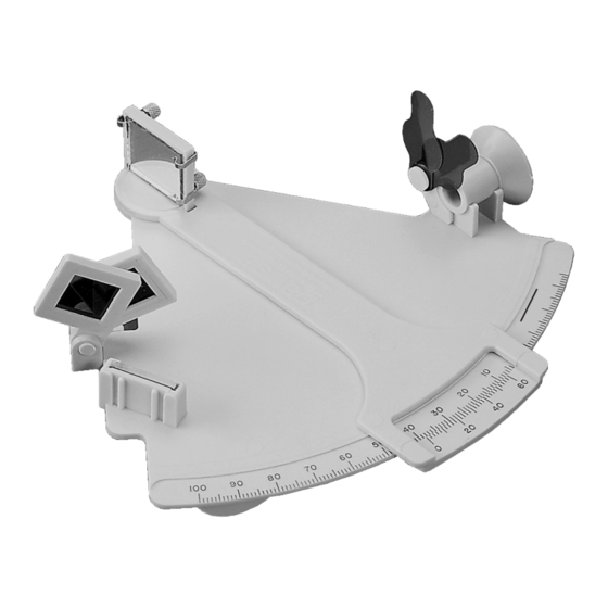
- Page 2 INDEX SHADES PIECE INDEX ARM HORIZON MIRROR OPTIONAL PROTECTIVE CASE Contact your local dealer or Davis Instruments to order. R014A Sextant Case R014B Foam Set for case Mark 3 Sextant User’s Guide Product #011 © 2008 Davis Instruments Corp. All rights reserved.
- Page 3 HOW TO FIND YOUR POSITION WITH A SEXTANT This booklet has been written as an introduction to your new Davis sextant. By studying its pages, you will learn how to operate your sextant, how to find the alti- tude of the sun, and how to use your readings to calculate location. The meridian transit method of navigation described is both easily learned and simply applied.
- Page 4 MARK 3 SEXTANT ADJUSTMENT Adjusting your Mark 3 Sextant is easy and should be done each time it is used. All adjustments are made with the index mirror, the large movable mirror at the pivot of the index arm (it is not necessary to adjust the small horizon mirror, as the unit construction makes it impossible to be very much in error).
- Page 5 Finally, remove the index error. Set the sextant at zero and look at the horizon. With the sextant still held to your eye, turn the screw that is furthest from the frame at the back of the index mirror until the two horizons move together and form one straight line.
- Page 6 To measure the sun’s altitude, stand facing the sun with the sextant in your right hand. With your left hand on the index arm, look through the eye piece at the hori- zon and move the index arm until the sun is visible through the two mirrors and index shades.
- Page 7 LATITUDE, LONGITUDE, and the NAUTICAL MILE A great circle is a circle on the surface of the earth, the plane of which passes through the center of the earth. A small circle is a circle whose plane does NOT pass through the center of the earth. The equator and the meridians are great cir- cles, while parallels of latitude are small circles which become progressively smaller as the distance form the equator increases.
- Page 8 DECLINATION Every star and planet, including the sun, has a ground position, i.e., the spot on the earth directly beneath it. Standing at the sun’s ground position (G.P.), you would have to look straight up to see the sun; if you were to measure its altitude with a sextant, you would find the altitude was 90°.
- Page 9 FINDING LOCAL NOON & THE SUN’S ALTITUDE AT MERIDIAN PASSAGE A meridian is an imaginary line drawn on the earth’s surface from pole to pole; a local meridian is one which passes through the position of an observer. When the sun crosses the local meridian, it is at its highest point.
- Page 10 meridian at 11:43:30 (exactly half the time between 11:23:30 and 12:03:30). Next, you find the Greenwich Mean Time (GMT) of your local noon by listening to the radio time signal, correcting any error your watch may have had. In this example, you tune in the time signal and find that GMT is now 22:10:00.
- Page 11 FINDING LATITUDE The altitude of the sun at local noon may also be used to calculate latitude. First, the measured altitude must be corrected for index error, height of eye, refraction, and semi-diameter. Refraction correction is negligible for altitudes above 25°, while the semi-diameter correction averages 0°...
- Page 12 Presentations shown here are commonly used by navigators to help insure the accuracy of their calculations: Figure 13 Figure 14 Longitude Diagram Latitude Diagram (view of earth looking at (view of earth looking at the South Pole) the Equator) Figure 14 Position plot on a chart.
- Page 13 (see below). It may be used by individuals exploring inland far from the sea, or by students or experienced navigators to practice celestial navigation without traveling to large bodies of water. Davis Instruments manufactures the Davis #144 Artificial Horizon, pictured here. The instrument is wind-proof and corrosion resis- tant;...
- Page 14 4. Line the two suns up by continuing to move the index arm. For a lower limb observation, bring the bottom of the mirror image into coincidence with the top of the image on the liquid. 5. After the observation has been made, apply the index correction. 6.
- Page 15 Figure 17 Since the sextant does not have a compass, you don’t need to worry about varia- tion or deviation. However, you must use at least three lines of position. THE SEXTANT AS A HELIOGRAPH You can use the sextant mirror to flash the sun’s rays several miles to attract attention, or to signal another person who is too far away for your voice to reach.
- Page 16 STUDENT NAVIGATION TABLES The tables on the following pages give the approximate declination and equation of time of the sun. Latitude calculated with these values will be accurate to about ± 15'. The tables are thus intended for study purposes only, although they may be used for emergency navigation.
- Page 17 REFERENCE: Approximate Declination & Equation of Time Page 15...
- Page 18 Page 16...
- Page 19 Page 17...
- Page 20 REPLACEMENT PARTS OTHER DAVIS SEXTANTS Contact your local dealer or Davis In addition to the Mark 3, Davis offers Instruments to order. Specify that your two models of master marine sextants. sextant is the #011 Mark 3. R011A Index Shade Assembly R011B 4 Springs, 2 Screws, 3 Nuts R011C Index &...
Need help?
Do you have a question about the Mark 3 and is the answer not in the manual?
Questions and answers