Sign In
Upload
Manuals
Brands
Garmin Manuals
GPS
GPSMAP 8000 Series
Garmin GPSMAP 8000 Series Manuals
Manuals and User Guides for Garmin GPSMAP 8000 Series. We have
9
Garmin GPSMAP 8000 Series manuals available for free PDF download: Owner's Manual, Instructions Manual, Installation Instructions Manual, Quick Start Manual
Garmin GPSMAP 8000 Series Owner's Manual (232 pages)
Brand:
Garmin
| Category:
GPS
| Size: 15.51 MB
Table of Contents
Table of Contents
3
Introduction
15
Protective Cover
15
Device Overview
15
Using the Touchscreen
16
On-Screen Buttons
16
Locking and Unlocking the Touchscreen
18
Connector View (8X10, 8X12, and 8X16 Models)
18
Connector View (8X17, 8X22, and 8X24 Models)
19
Connector View (8700 Models)
20
Connector View (9000 Models)
21
Tips and Shortcuts (MFD Models)
22
Tips and Shortcuts (8700 Model)
23
Accessing Owner's Manuals on the Chartplotter
23
Accessing the Manuals from the Web
23
Garmin Support Center
23
Memory Cards
24
Inserting Memory Cards (GPSMAP 8X10/8X12/8X16/9X19/9X22/9X24/9X27)
25
Inserting a Memory Card (GPSMAP 8X17/8X22/8X24/87Xx)
26
Acquiring GPS Satellite Signals
26
Selecting the GPS Source
26
Customizing the Chartplotter
27
Home Screen
27
Pinning a Feature Button
28
Rearranging the Category Items
28
Menu Bar
28
Hiding and Showing the Menu Bar
29
Setting the Vessel Type
29
Adjusting the Backlight
29
Adjusting the Color Mode
29
Enabling Screen Lock
30
Turning on the Chartplotter Automatically
30
Automatically Turning off the System
30
Customizing Pages
30
Customizing the Startup Screen
30
Recommended Startup Image Dimensions
31
Creating a New Combination Page
31
Adding a Smartmode Layout
32
Customizing the Layout of a Smartmode or Combination Page
32
Deleting a Combination Page
32
Customizing the Data Overlays
33
Resetting the Station Layouts
33
Presets
33
Managing Presets
33
Saving a New Preset
33
Controlling the Chartplotter
34
Voice Control
34
Changing the Voice Control Language
34
Supported Headsets
34
Pairing a Wireless Headset with a Garmin Chartplotter
34
Using a Wireless Headset with a Garmin Chartplotter
34
Chartplotter Voice Commands
35
GRID Remote Control
38
Pairing the GRID Device with the Chartplotter from the Chartplotter
38
Pairing the GRID Device with the Chartplotter from the GRID Device
38
Rotating the GRID Remote Input Device
38
Activecaptain App
39
Activecaptain and Garmin Bluenet Considerations
39
Activecaptain Roles
39
Getting Started with the Activecaptain App
40
Enabling Smart Notifications
40
Receiving Notifications
41
Managing Notifications
41
Making Notifications Private
41
Updating Software with the Activecaptain App
42
Updating Charts with Activecaptain
42
Chart Subscriptions
42
Communication with Wireless Devices
42
Wi-Fi Network
43
Setting up the Wi-Fi Network
43
Connecting a Wireless Device to the Chartplotter
43
Changing the Wireless Channel
43
Changing the Wi-Fi Host
43
Wireless Remote Control
43
Pairing the Wireless Remote Control with the Chartplotter
43
Turning on and off the Remote Backlight
44
Disconnecting the Remote Control from All Chartplotters
44
Wireless Wind Sensor
44
Connecting a Wireless Sensor to the Chartplotter
44
Adjusting the Wind Sensor Orientation
44
Viewing Boat Data on a Garmin Watch
44
Viewing Boat Data on a Garmin Nautix™ Device
45
Charts and 3D Chart Views
45
Detailed Charts
45
Activating a Marine Chart Subscription
46
Purchasing a Chart Subscription with Activecaptain
46
Renewing Your Subscription
46
Navigation Chart and Fishing Chart
47
Chart Symbols
47
Zooming in and out Using the Touchscreen
47
Measuring a Distance on the Chart
48
Creating a Waypoint on the Chart
48
Viewing Location and Object Information on a Chart
48
Viewing Details about Navaids
48
Navigating to a Point on the Chart
49
Premium Chart Features
50
Fish Eye 3D Chart View
51
Viewing Tide Station Information
51
Animated Tide and Current Indicators
52
Showing Tides and Current Indicators
52
Showing Satellite Imagery on the Navigation Chart
52
Viewing Aerial Photos of Landmarks
53
Automatic Identification System
53
AIS Targeting Symbols
53
Heading and Projected Course of Activated AIS Targets
54
Activating a Target for an AIS Vessel
54
Viewing Information about a Targeted AIS Vessel
54
Deactivating a Target for an AIS Vessel
54
Showing AIS Vessels on a Chart or 3D Chart View
55
Setting the Safe-Zone Collision Alarm
55
Viewing a List of AIS Threats
55
AIS Aids to Navigation
56
AIS Distress Signals
57
Navigating to a Distress Signal Transmission
57
AIS Distress Signal Device Targeting Symbols
57
Enabling AIS Transmission Test Alerts
57
Turning off AIS Reception
57
Chart Menu
58
Chart Layers
58
Chart Layer Settings
58
Depth Layer Settings
59
My Vessel Layer Settings
59
Laylines Settings
59
User Data Layer Settings
60
Other Vessels Layer Settings
60
Water Layer Settings
60
Depth Range Shading
61
Weather Layer Settings
61
Radar Overlay Settings
62
Chart Settings
62
Fish Eye 3D Settings
62
Supported Maps
63
Garmin Quickdraw Contours Mapping
63
Mapping a Body of Water Using the Garmin Quickdraw Contours Feature
63
Adding a Label to a Garmin Quickdraw Contours Map
64
Garmin Quickdraw Community
64
Connecting to the Garmin Quickdraw Community with Activecaptain
64
Downloading Garmin Quickdraw Community Maps Using Activecaptain
64
Sharing Your Garmin Quickdraw Contours Maps with the Garmin Quickdraw Community Using Activecaptain
64
Connecting to the Garmin Quickdraw Community with Garmin Connect
65
Sharing Your Garmin Quickdraw Contours Maps with the Garmin Quickdraw Community Using Garmin Connect
65
Downloading Garmin Quickdraw Community Maps Using Garmin Connect
65
Garmin Quickdraw Contours Settings
66
Navigation with a Chartplotter
66
Basic Navigation Questions
67
Route Color Coding
67
Destinations
68
Searching for a Destination by Name
68
Selecting a Destination Using the Navigation Chart
68
Searching for a Marine Services Destination
68
Setting and Following a Direct Course Using Go to
68
Stopping Navigation
69
Waypoints
69
Marking Your Present Location as a Waypoint
69
Creating a Waypoint at a Different Location
69
Marking a man Overboard or Other SOS Location
69
Projecting a Waypoint
69
Viewing a List of All Waypoints
69
Editing a Saved Waypoint
70
Moving a Saved Waypoint
70
Browsing for and Navigating to a Saved Waypoint
71
Deleting a Waypoint or an MOB
71
Deleting All Waypoints
71
Routes
71
Creating and Navigating a Route from Your Present Location
72
Creating and Saving a Route
72
Viewing a List of Routes and Auto Guidance Paths
72
Editing a Saved Route
72
Finding and Navigating a Saved Route
73
Browsing for and Navigating Parallel to a Saved Route
73
Initiating a Search Pattern
74
Deleting a Saved Route
74
Deleting All Saved Routes
74
Auto Guidance
74
Setting and Following an Auto Guidance Path
74
Creating and Saving an Auto Guidance Path
75
Adjusting a Saved Auto Guidance Path
75
Canceling an Auto Guidance Calculation in Progress
75
Setting a Timed Arrival
75
Auto Guidance Path Configurations
76
Adjusting the Distance from Shore
77
Tracks
77
Showing Tracks
77
Setting the Color of the Active Track
78
Saving the Active Track
78
Viewing a List of Saved Tracks
78
Editing a Saved Track
78
Saving a Track as a Route
78
Browsing for and Navigating a Recorded Track
78
Deleting a Saved Track
78
Deleting All Saved Tracks
78
Retracing the Active Track
79
Clearing the Active Track
79
Managing the Track Log Memory During Recording
79
Configuring the Recording Interval of the Track Log
79
Boundaries
79
Creating a Boundary
80
Converting a Route to a Boundary
80
Converting a Track to a Boundary
80
Editing a Boundary
80
Linking a Boundary to a Smartmode Layout
80
Setting a Boundary Alarm
80
Disabling All Boundary Alarms
80
Deleting a Boundary
81
Deleting All Saved Waypoints, Tracks, Routes, and Boundaries
81
Sailing Features
81
Setting the Vessel Type for Sailing Features
81
Sail Racing
81
Starting Line Guidance
81
Setting the Starting Line
81
Using the Starting Line Guidance
82
Starting the Race Timer
82
Stopping the Race Timer
82
Setting the Distance between the Bow and the GPS Antenna
82
Laylines Settings
83
Polar Tables
83
Importing a Polar Table Manually
84
Showing Polar Data in Data Fields
84
Setting the Keel Offset
85
Sailboat Autopilot Operation
86
Wind Hold
86
Changing the Wind Hold Type
86
Engaging Wind Hold
87
Engaging Wind Hold from Heading Hold
87
Adjusting the Wind Hold Angle
87
Tack and Gybe
87
Tacking and Gybing from Heading Hold
87
Tacking and Gybing from Wind Hold
87
Setting a Tack Delay
87
Enabling the Gybe Inhibitor
88
Heading Line and Angle Markers
88
Setting the Heading Line and Angle Markers
88
Viewing Sailing Vessel Data
88
Sonar Fishfinder
89
Stopping the Transmission of Sonar Signals
89
Traditional Sonar View
89
Split-Frequency Sonar View
89
Split-Zoom Sonar View
90
Garmin Clearvü Sonar View
90
Garmin Sidevü Sonar View
91
Sidevü Scanning Technology
92
Measuring Distance on the Sonar Screen
92
Panoptix Sonar Views
92
Livevü down Sonar View
93
Livevü Forward Sonar View
94
Realvü 3D Forward Sonar View
95
Realvü 3D down Sonar View
96
Realvü 3D Historical Sonar View
97
Frontvü Sonar View
98
Livescope Sonar View
98
Perspective View
99
Selecting the Transducer Type
99
Selecting a Sonar Source
99
Renaming a Sonar Source
100
Creating a Waypoint on the Sonar Screen
100
Pausing the Sonar Display
100
Viewing Sonar History
100
Sonar Sharing
100
Zooming in a Panoptix Livevü or Livescope Sonar View
101
Adjusting the Level of Detail
101
Adjusting the Color Intensity
102
Sonar Setup
102
Setting the Zoom Level on the Sonar Screen
103
Setting the Scroll Speed
103
Adjusting the Range
103
Sonar Noise Rejection Settings
104
Sonar Appearance Settings
104
Sonar Alarms
105
Advanced Sonar Settings
106
Transducer Installation Settings
106
Sonar Frequencies
107
Selecting the Transducer Frequency
107
Creating a Frequency Preset
107
Turning on the A-Scope
108
Panoptix Sonar Setup
108
Adjusting the Realvü Viewing Angle and Zoom Level
108
Adjusting the Realvü Sweep Speed
108
Livevü Forward and Frontvü Sonar Settings
109
Setting the Livevü and Frontvü Transducer Transmit Angle
109
Setting the Frontvü Depth Alarm
110
Livevü and Frontvü Appearance Settings
110
Livevü and Frontvü Layout Settings
110
Realvü Appearance Settings
111
Panoptix Transducer Installation Settings
111
Setting the Bow Offset
112
Calibrating the Compass
112
Livescope and Perspective Sonar Settings
113
Livescope and Perspective Sonar Setup
113
Livescope and Perspective Appearance Settings
114
Livescope and Perspective Layout Settings
114
Livescope and Perspective Transducer Installation Settings
114
Radar
115
Radar Interpretation
115
Radar Overlay
115
Radar Overlay and Chart Data Alignment
116
Transmitting Radar Signals
116
Stopping the Transmission of Radar Signals
116
Setting up the Timed Transmit Mode
116
Enabling and Adjusting a Radar no Transmit Zone
116
Adjusting the Radar Range
117
Tips for Selecting a Radar Range
117
Motionscope Doppler Radar Technology
117
Enabling a Guard Zone
117
Defining a Circular Guard Zone
118
Defining a Partial Guard Zone
118
Marpa
118
MARPA Targeting Symbols
119
Acquiring MARPA Targets Automatically
119
Removing MARPA Targets Automatically
119
Assigning a MARPA Tag to an Object
119
Removing a MARPA Tag from a Targeted Object
119
Viewing Information about a MARPA-Tagged Object
119
Viewing a List of AIS Threats
119
Showing AIS Vessels on the Radar Screen
120
VRM and EBL
120
Showing and Adjusting the VRM and the EBL
120
Measuring the Range and Bearing to a Target Object
120
Echo Trails
121
Advertisement
Garmin GPSMAP 8000 Series Owner's Manual (62 pages)
Brand:
Garmin
| Category:
GPS
| Size: 2.92 MB
Table of Contents
Table of Contents
3
Introduction
9
Device Overview
9
Using the Touchscreen
9
On-Screen Buttons
9
Tips and Shortcuts
9
Locking the Touchscreen
9
Accessing Owner's Manuals on the Chartplotter
9
Downloading the Manuals
9
Getting more Information
9
Inserting a Memory Card
9
Software Update
10
Loading the New Software on a Memory Card
10
Updating the Device Software
10
GPS Satellite Signals
10
Selecting the GPS Source
10
Customizing the Chartplotter
10
Home Screen
10
Adding an Item to Favorites
10
Customizing Pages
10
Customizing the Layout of a Smartmode or Combination Page
10
Adding a Smartmode Layout
11
Adding a Custom Combination Screen
11
Customizing the Data Overlays
11
Resetting the Station Layouts
11
Presets
11
Saving a New Preset
11
Managing Presets
11
Setting the Vessel Type
11
Adjusting the Backlight
11
Adjusting the Color Mode
11
Navigation Chart and Offshore Fishing Chart
12
Zooming in and out Using the Touchscreen
12
Selecting a Map
12
Measuring a Distance on the Chart
12
Chart Symbols
12
Creating a Waypoint on the Chart
12
Viewing Location and Object Information on a Chart
12
Viewing Details about Navaids
12
Navigating to a Point on the Chart
12
Heading Line and Angle Markers
13
Setting the Heading and Course over Ground Lines
13
Turning on Angle Markers
13
Premium Charts
13
Viewing Tide Station Information
13
Animated Tide and Current Indicators
13
Showing Tides and Current Indicators
14
Showing Satellite Imagery on the Navigation Chart
14
Viewing Aerial Photos of Landmarks
14
Automatic Identification System
14
AIS Targeting Symbols
14
Heading and Projected Course of Activated AIS Targets
14
Showing AIS and MARPA Vessels on a Chart or on a 3D Chart View
15
Activating a Target for an AIS Vessel
15
Viewing Information about a Targeted AIS Vessel
15
Deactivating a Target for an AIS Vessel
15
Viewing a List of AIS and MARPA Threats
15
Setting the Safe-Zone Collision Alarm
15
AIS Distress Signals
15
Navigating to a Distress Signal Transmission
15
AIS Distress Signal Device Targeting Symbols
15
Enabling AIS Transmission Test Alerts
15
Navigation and Fishing Chart Setup
16
Waypoints and Tracks Settings on the Charts and Chart Views
16
Chart Appearance Settings
16
Other Vessels Settings on the Charts and Chart Views
16
Laylines Settings
17
Fish Eye 3D Settings
17
Garmin Quickdraw™ Contours Mapping
17
Mapping a Body of Water Using the Garmin Quickdraw Contours Feature
17
Adding a Label to a Garmin Quickdraw Contours Map
17
Garmin Quickdraw Community
17
Accessing the Garmin Quickdraw Community
17
Sharing Your Garmin Quickdraw Contours Maps with the Garmin Quickdraw Community
17
Downloading Garmin Quickdraw Community Maps
18
Garmin Quickdraw Contours Settings
18
Navigation with a Chartplotter
18
Basic Navigation Questions
18
Destinations
19
Searching for a Destination by Name
19
Selecting a Destination Using the Navigation Chart
19
Searching for a Marine Services Destination
19
Stopping Navigation
19
Waypoints
19
Marking Your Present Location as a Waypoint
19
Creating a Waypoint at a Different Location
19
Marking an SOS Location
19
Viewing a List of All Waypoints
19
Deleting a Waypoint or an MOB
20
Deleting All Waypoints
20
Setting and Following a Direct Course Using Go to
20
Routes
20
Creating and Navigating a Route from Your Present Location
20
Creating and Saving a Route
20
Viewing a List of Routes and Auto Guidance Paths
20
Editing a Saved Route
20
Browsing for and Navigating a Saved Route
20
Browsing for and Navigating Parallel to a Saved Route
20
Deleting a Saved Route
21
Deleting All Saved Routes
21
Auto Guidance
21
Setting and Following an Auto Guidance Path
21
Creating and Saving an Auto Guidance Path
21
Adjusting a Saved Auto Guidance Path
21
Canceling an Auto Guidance Calculation in Progress
21
Setting a Timed Arrival
21
Auto Guidance Path Configurations
21
Adjusting the Distance from Shore
22
Tracks
22
Showing Tracks
22
Setting the Color of the Active Track
22
Saving the Active Track
22
Viewing a List of Saved Tracks
22
Editing a Saved Track
22
Saving a Track as a Route
22
Browsing for and Navigating a Recorded Track
22
Deleting a Saved Track
22
Clearing the Active Track
23
Managing the Track Log Memory During Recording
23
Configuring the Recording Interval of the Track Log
23
Boundaries
23
Creating a Boundary
23
Converting a Route to a Boundary
23
Converting a Track to a Boundary
23
Editing a Boundary
23
Setting a Boundary Alarm
23
Deleting a Boundary
23
Starting Line Guidance
24
Setting the Starting Line
24
Using the Starting Line Guidance
24
Starting the Race Timer
24
Stopping the Race Timer
24
Setting the Distance between the Bow and the GPS Antenna
24
Laylines Settings
24
Setting the Keel Offset
24
Sailboat Autopilot Operation
25
Wind Hold
25
Setting the Wind Hold Type
25
Engaging Wind Hold
25
Engaging Wind Hold from Heading Hold
25
Adjusting the Wind Hold Angle with the Autopilot
25
Tack and Gybe
25
Tacking and Gybing from Heading Hold
25
Tacking and Gybing from Wind Hold
25
Setting a Tack and Gybe Delay
25
Garmin Clearvü Sonar View
26
Sidevü Sonar View
26
Sidevü Scanning Technology
26
Split-Zoom Sonar View
26
Split-Frequency Sonar View
26
Panoptix Sonar Views
26
Livevü down Sonar View
26
Livevü Forward Sonar View
27
Realvü 3D Forward Sonar View
27
Realvü 3D down Sonar View
27
Realvü 3D Historical Sonar View
27
Frontvü Sonar View
27
Changing the Sonar View
27
Selecting the Transducer Type
27
Calibrating the Compass
28
Creating a Waypoint on the Sonar Screen
28
Measuring Distance on the Sonar Screen
28
Pausing the Sonar Display
28
Viewing Sonar History
28
Sonar Sharing
28
Selecting a Sonar Source
28
Garmin GPSMAP 8000 Series Owner's Manual (66 pages)
Brand:
Garmin
| Category:
GPS
| Size: 5.97 MB
Table of Contents
Table of Contents
3
Introduction
9
Device Overview
9
Using the Touchscreen
9
On-Screen Buttons
9
Locking and Unlocking the Touchscreen
9
Tips and Shortcuts
9
Accessing Owner's Manuals on the Chartplotter
9
Downloading the Manuals
9
Garmin Support Center
10
Inserting a Memory Card
10
Acquiring GPS Satellite Signals
10
Selecting the GPS Source
10
Customizing the Chartplotter
10
Home Screen
10
Adding an Item to Favorites
10
Customizing Pages
10
Customizing the Layout of a Smartmode or Combination Page
10
Adding a Smartmode Layout
10
Creating a New Combination Page
11
Deleting a Combination Page
11
Customizing the Data Overlays
11
Resetting the Station Layouts
11
Presets
11
Saving a New Preset
11
Managing Presets
11
Setting the Vessel Type
11
Adjusting the Backlight
11
Adjusting the Color Mode
11
Customizing the Startup Screen
12
Turning on the Chartplotter Automatically
12
Automatically Turning off the System
12
Activecaptain™ App
12
Activecaptain Roles
12
Getting Started with the Activecaptain App
12
Updating Software with the Activecaptain App
12
Updating Charts with Activecaptain
12
Communication with Wireless Devices
13
Wi-Fi Network
13
Setting up the Wi-Fi Wireless Network
13
Connecting a Wireless Device to the Chartplotter
13
Changing the Wireless Channel
13
Changing the Wi-Fi Host
13
Charts and 3D Chart Views
13
Navigation Chart and Fishing Chart
13
Zooming in and out Using the Touchscreen
14
Chart Symbols
14
Measuring a Distance on the Chart
14
Creating a Waypoint on the Chart
14
Viewing Location and Object Information on a Chart
14
Viewing Details about Navaids
14
Navigating to a Point on the Chart
14
Premium Charts
14
Viewing Tide Station Information
15
Animated Tide and Current Indicators
15
Showing Tides and Current Indicators
15
Showing Satellite Imagery on the Navigation Chart
15
Viewing Aerial Photos of Landmarks
15
Automatic Identification System
15
AIS Targeting Symbols
15
Heading and Projected Course of Activated AIS Targets
16
Activating a Target for an AIS Vessel
16
Viewing Information about a Targeted AIS Vessel
16
Deactivating a Target for an AIS Vessel
16
Viewing a List of AIS and MARPA Threats
16
Setting the Safe-Zone Collision Alarm
16
AIS Distress Signals
16
Navigating to a Distress Signal Transmission
16
AIS Distress Signal Device Targeting Symbols
16
Enabling AIS Transmission Test Alerts
16
Chart Menu
17
Chart Layers
17
Chart Layer Settings
17
Depth Layer Settings
17
My Vessel Layer Settings
17
Laylines Settings
17
User Data Layer Settings
17
Other Vessels Layer Settings
18
Water Layer Settings
18
Weather Layer Settings
18
Radar Overlay Settings
18
Chart Settings
18
Fish Eye 3D Settings
18
Supported Maps
18
Garmin Quickdraw Contours Mapping
18
Mapping a Body of Water Using the Garmin Quickdraw Contours Feature
19
Adding a Label to a Garmin Quickdraw Contours Map
19
Garmin Quickdraw Community
19
Connecting to the Garmin Quickdraw Community with Activecaptain
19
Downloading Garmin Quickdraw Community Maps Using Activecaptain
19
Sharing Your Garmin Quickdraw Contours Maps with the Garmin Quickdraw Community Using Activecaptain
19
Connecting to the Garmin Quickdraw Community with Garmin Connect
19
Sharing Your Garmin Quickdraw Contours Maps with the Garmin Quickdraw Community Using Garmin Connect
19
Downloading Garmin Quickdraw Community Maps Using Garmin Connect
19
Garmin Quickdraw Contours Settings
20
Depth Range Shading
20
Navigation with a Chartplotter
20
Basic Navigation Questions
21
Destinations
21
Searching for a Destination by Name
21
Selecting a Destination Using the Navigation Chart
21
Searching for a Marine Services Destination
21
Stopping Navigation
21
Waypoints
21
Marking Your Present Location as a Waypoint
21
Creating a Waypoint at a Different Location
21
Marking an SOS Location
21
Deleting a Waypoint or an MOB
22
Deleting All Waypoints
22
Setting and Following a Direct Course Using Go to
22
Routes
22
Creating and Navigating a Route from Your Present Location
22
Creating and Saving a Route
22
Viewing a List of Routes and Auto Guidance Paths
22
Editing a Saved Route
22
Browsing for and Navigating a Saved Route
22
Browsing for and Navigating Parallel to a Saved Route
23
Deleting a Saved Route
23
Deleting All Saved Routes
23
Auto Guidance
23
Advertisement
Garmin GPSMAP 8000 Series Owner's Manual (52 pages)
Brand:
Garmin
| Category:
GPS
| Size: 2.45 MB
Table of Contents
Table of Contents
3
Customizing the Chartplotter
7
Introduction
7
Downloading the Manuals
7
Front View
7
Getting more Information
7
Gps Satellite Signals
7
Home Screen
7
Adding a Custom Combination Screen
8
Adding an Item to Favorites
8
Resetting the Station Layouts
8
Software Update
7
Adjusting the Backlight
8
Adjusting the Color Mode
8
Adding a Smartmode Layout
8
Charts and 3D Chart Views
8
Navigation Chart and Offshore Fishing Chart
9
Chart Symbols
9
Showing a Different Chart
9
Viewing Location and Object Information on a Chart
9
Zooming in and out Using the Touchscreen
9
Premium Charts
10
Viewing Details about Navaids
10
Viewing Tide Station Information
10
Showing Satellite Imagery on the Navigation Chart
11
Viewing Aerial Photos of Landmarks
11
Automatic Identification System
11
Ais Targeting Symbols
11
Chart and 3D Chart View Settings
12
Turning off Ais Reception
12
Setting the Safe-Zone Collision Alarm
12
Ais Distress Signals
12
Navigation and Fishing Chart Setup
13
Chart Appearance Settings
13
Navigation with a Chartplotter
14
Basic Navigation Questions
14
Searching for a Destination by Name
14
Selecting a Destination Using the Navigation Chart
14
Searching for a Marine Services Destination
14
Creating a Waypoint at a Different Location
14
Marking an Sos Location
14
Deleting All Waypoints
15
Auto Guidance
16
Auto Guidance Line Configurations
17
Showing Tracks
17
Stopping Navigation
18
Retracing the Active Track
18
Synchronizing User Data Across the Garmin Marine Network
18
Setting the Keel Offset
19
Sailing Features
19
Sail Racing
19
Starting Line Guidance
19
Sonar
20
Sonar Views
20
Sailboat Autopilot Operation
20
Wind Hold
20
Traditional Sonar View
20
Downvü Sonar View
20
Sidevü Sonar View
21
Split-Zoom Sonar View
21
Split-Frequency Sonar View
21
Changing the Sonar View
22
Creating a Waypoint on the Sonar Screen
22
Measuring Distance on the Sonar Screen
22
Pausing the Sonar Display
22
Viewing Sonar History
22
Sonar Sharing
22
Selecting a Sonar Source
22
Renaming a Sonar Source
22
Adjusting the Level of Detail
22
Adjusting the Color Intensity
23
Adjusting the Range of the Depth or Width Scale
23
Setting the Zoom Level on the Sonar Screen
23
Setting the Scroll Speed
23
Sonar Frequencies
23
Selecting Frequencies
24
Creating a Frequency Preset
24
Customizing the Panoptix Sonar Views
24
Adjusting the Appearance of the Livevü Sonar Views
24
Setting the Livevü Transducer Transmit Angle
24
Adjusting the Realvü Viewing Angle and Zoom Level
24
Adjusting the Appearance of the Realvü Sonar Views
24
Adjusting the Realvü Sweep Speed
24
Turning on the A-Scope
24
Selecting the Transducer Type
24
Realvü Sonar Settings
25
Livevü Sonar Settings
25
Sonar Noise Rejection Settings
25
Sonar Appearance Settings
25
Sonar Alarm Settings
25
Advanced Sonar Settings
25
Transducer Installation Settings
26
Sonar Recordings
26
Recording the Sonar Display
26
Stopping the Sonar Recording
26
Deleting a Sonar Recording
26
Playing Sonar Recordings
26
Radar
26
Radar Display Modes
26
Changing the Radar Mode
27
Transmitting Radar Signals
27
Adjusting the Radar Range
27
Tips for Selecting a Radar Range
27
Zooming in and out of the Radar Screen
27
Marking a Waypoint on the Radar Screen
27
Sentry Mode
27
Enabling Timed Transmit
27
Setting the Standby and Transmit Times
27
Enabling a Guard Zone
27
MARPA Targeting Symbols
28
Assigning a MARPA Tag to an Object
28
Viewing a List of AIS and MARPA Threats
28
Showing AIS Vessels on the Radar Screen
28
VRM and EBL
28
Radar Overlay
28
Radar Overlay and Chart Data Alignment
28
Showing the Radar Overlay
29
Setting a Custom Park Position
29
Enabling and Adjusting a Radar no Transmit Zone
29
Stopping the Transmission of Radar Signals
29
Optimizing the Radar Display
29
Radar Gain and Clutter
29
Echo Trails
30
Radar Display Settings
30
Radar Appearance Settings
30
Front-Of-Boat Offset
30
Selecting a Different Radar Source
31
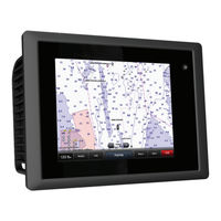
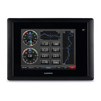
Garmin GPSMAP 8000 Series Owner's Manual (36 pages)
GPSMAP® 8000 Glass Helm Series
Brand:
Garmin
| Category:
Marine GPS System
| Size: 6.58 MB
Table of Contents
Table of Contents
3
Introduction
7
GPSMAP 8000 Series Front View
7
Inserting a Memory Card
7
Using the Touchscreen
7
Locking the Touchscreen
7
Tips and Shortcuts
7
GPS Satellite Signals
7
Stations and Station Layouts
7
Customizing the Home Screen
7
Customizing the Layout of a Page
7
Resetting the Station Layouts
8
Adjusting the Backlight
8
Adjusting the Color Mode
8
Charts and 3D Chart Views
8
Chart Symbols
8
Showing a Different Chart
8
Zooming in and out Using the Touchscreen
8
Viewing Location and Object Information on a Chart
8
Navigating to a Point on the Chart
9
Viewing Details about Navaids
9
Premium Charts
9
Viewing Tide Station Information
9
Animated Tide and Current Indicators
9
Showing and Configuring Tides and Currents
10
Showing Satellite Imagery on the Navigation Chart
10
Viewing Aerial Photos of Landmarks
10
Automatic Identification System
10
AIS Targeting Symbols
10
Heading and Projected Course of Activated AIS Targets
10
Showing AIS and MARPA Vessels on a Chart or on a 3D Chart View
10
Activating a Target for an AIS Vessel
11
Viewing Information about a Targeted AIS Vessel
11
Deactivating a Target for an AIS Vessel
11
Viewing a List of AIS and MARPA Threats
11
Setting the Safe-Zone Collision Alarm
11
AIS Distress Signals
11
Navigating to a Distress Signal Transmission
11
AIS Distress Signal Device Targeting Symbols
11
Enabling AIS Transmission Test Alerts
11
Turning off AIS Reception
11
Navigation and Fishing Chart Setup
12
Waypoints and Tracks Settings on the Charts and Chart Views
12
Chart Appearance Settings
12
Other Vessels Settings on the Charts and Chart Views
12
Fish Eye 3D Settings
12
Navigation with a Chartplotter
12
Basic Navigation Questions
13
Destinations
13
Searching for a Destination by Name
13
Selecting a Destination Using the Navigation Chart
13
Searching for a Marine Services Destination
13
Courses
13
Setting and Following a Direct Course Using Go to
13
Setting and Following a Course Using Auto Guidance
13
Autopilot Navigation
13
Recalculating the Auto Guidance Route
13
Waypoints
14
Marking Your Present Location as a Waypoint
14
Creating a Waypoint at a Different Location
14
Marking and Navigating to an MOB Location
14
Viewing a List of All Waypoints
14
Editing a Saved Waypoint
14
Moving a Saved Waypoint
14
Browsing for and Navigating to a Saved Waypoint
14
Deleting a Waypoint or an MOB
14
Deleting All Waypoints
14
Viewing a List of Routes
15
Editing a Saved Route
15
Browsing for and Navigating a Saved Route
15
Browsing for and Navigating Parallel to a Saved Route
15
Deleting a Saved Route
15
Deleting All Saved Routes
15
Tracks
15
Showing Tracks
15
Setting the Color of the Active Track
15
Saving the Active Track
15
Deleting a Saved Track
16
Deleting All Saved Tracks
16
Retracing the Active Track
16
Clearing the Active Track
16
Managing the Track Log Memory During Recording
16
Configuring the Recording Interval of the Track Log
16
Deleting All Saved Waypoints, Routes, and Tracks
16
Sonar
16
Changing the Sonar View
16
Pausing the Sonar Display
16
Turning on the A-Scope
17
Sonar Setup
17
Sonar Settings
17
Sonar Noise Rejection Settings
17
Sonar Appearance Settings
17
Sonar Alarm Settings
17
Advanced Sonar Settings
17
Transducer Installation Settings
17
Garmin GPSMAP 8000 Series Owner's Manual (43 pages)
Brand:
Garmin
| Category:
GPS
| Size: 4.65 MB
Table of Contents
GPSMAP 8000 Series Front View
2
Inserting a Memory Card
2
Accessing Owner's Manuals on the Chartplotter
2
Software Update
2
Customizing the Chartplotter
3
Adjusting the Backlight
4
Charts and 3D Chart Views
4
Premium Charts
5
Automatic Identification System
6
Setting the Safe-Zone Collision Alarm
7
AIS Distress Signals
7
Turning off AIS Reception
7
Chart and 3D Chart View Settings
8
Navigation and Fishing Chart Setup
8
Chart Appearance Settings
8
Navigation with a Chartplotter
9
Basic Navigation Questions
9
Deleting All Waypoints
10
Auto Guidance
11
Auto Guidance Line Configurations
12
Showing Tracks
13
Retracing the Active Track
13
Stopping Navigation
13
Sailing Features
14
Laylines Settings
14
Sailboat Autopilot Operation
15
Sonar Views
15
Panoptix ™ Sonar Views
16
Creating a Waypoint on the Sonar Screen
17
Measuring Distance on the Sonar Screen
17
Sonar Sharing
17
Adjusting the Level of Detail
18
Adjusting the Color Intensity
18
Adjusting the Range of the Depth or Width Scale
18
Setting the Zoom Level on the Sonar Screen
18
Setting the Scroll Speed
18
Sonar Frequencies
19
Customizing the Panoptix Sonar Views
19
Turning on the A-Scope
19
Selecting the Transducer Type
20
Sonar Setup
20
Transducer Installation Settings
21
Sonar Recordings
21
Transmitting Radar Signals
22
Defining a Circular Guard Zone
23
Radar Targeting and MARPA
23
MARPA Targeting Symbols
23
Radar Overlay
24
Setting a Custom Park Position
24
Enabling and Adjusting a Radar no Transmit Zone
24
Garmin GPSMAP 8000 Series Instructions Manual (15 pages)
Installation Instructions
Brand:
Garmin
| Category:
Marine GPS System
| Size: 2.06 MB
Table of Contents
Registering Your Device
1
Contacting Garmin Product Support
1
Antenna Mounting Considerations
3
Connecting to Power
5
Cable and Connection Considerations
5
Garmin Marine Network Considerations
6
NMEA 0183 Connection Considerations
6
Updating the Device Software
12
Physical Specifications
12
Power Specifications
12
NMEA 0183 Information
13
Garmin GPSMAP 8000 Series Installation Instructions Manual (14 pages)
Brand:
Garmin
| Category:
Fish Finder
| Size: 1.71 MB
Table of Contents
Antenna Mounting Considerations
3
Connecting to Power
5
NMEA 0183 Connection Considerations
6
Lamp or Horn Connections
11
Physical Specifications
13
Garmin GPSMAP 8000 Series Quick Start Manual (4 pages)
Quick Start Manual
Brand:
Garmin
| Category:
Marine GPS System
| Size: 2.93 MB
Advertisement
Related Products
Garmin GPSMAP 8012
Garmin GPSMAP 8008
Garmin nuvi 885T
Garmin GPSMAP 86
Garmin Camper 890
Garmin GPSMAP 8X22
Garmin GPSMAP 8X10
Garmin GPSMAP 8X12
Garmin GPSMAP 86sci
Garmin GPSMAP 87 Series
Garmin Categories
GPS
Watch
Car Navigation system
Avionics Display
Marine GPS System
More Garmin Manuals
Login
Sign In
OR
Sign in with Facebook
Sign in with Google
Upload manual
Upload from disk
Upload from URL