Garmin GPSMAP 7400 Series Owner's Manual
Hide thumbs
Also See for GPSMAP 7400 Series:
- Owner's manual (176 pages) ,
- Installation instructions manual (9 pages) ,
- Installation insrtuctions (7 pages)

Related Manuals for Garmin GPSMAP 7400 Series


Summary of Contents for Garmin GPSMAP 7400 Series
- Page 1 GPSMAP 7400/7600 Series ® Owner’s Manual February 2015 Printed in Taiwan 190-01841-00_0B...
-
Page 3: Table Of Contents
Viewing Aerial Photos of Landmarks ........5 Stopping Navigation ..............12 Automatic Identification System ..........5 Synchronizing User Data Across the Garmin Marine AIS Targeting Symbols ............5 Network ..................12 Heading and Projected Course of Activated AIS Targets ..5 Deleting All Saved Waypoints, Routes, and Tracks .... - Page 4 Changing the Sonar View ............ 16 Echo Trails ................24 Creating a Waypoint on the Sonar Screen ....... 16 Radar Display Settings ............24 Measuring Distance on the Sonar Screen ........ 16 Radar Appearance Settings ..........24 Pausing the Sonar Display ............16 Front-of-Boat Offset .............
- Page 5 Surface Winds ..............33 Disconnecting the Remote from All Chartplotters ....39 Wave Height, Wave Period, and Wave Direction ....33 Using the Garmin Helm Application with the Chartplotter ..39 Viewing Forecast Sea Conditions Information for Another Chartplotter Data Management ........39 Time Period ................
- Page 6 Restoring Backup Data to a Chartplotter ........40 Saving System Information to a Memory Card ......40 Appendix............... 40 Registering Your Device ............40 Digital Switching ............... 40 Rotating the GRID Joystick ............40 Cleaning the Screen ..............40 Screenshots ................40 Capturing Screenshots ............
-
Page 7: Software Update
® website at www.garmin.com presents up-to-date Select Download next to Garmin Marine Network with SD information about your product. The support pages will provide card. answers to frequently asked support questions, and you can download software and chart updates. There is also contact Read and agree to the terms. -
Page 8: Adding A Custom Combination Screen
Home. • To change the function of the portion of the screen, select When multiple displays are installed on the Garmin Marine the area to change, and select a function from the list on Network, you can group them together into a station. A station the right. -
Page 9: Navigation Chart And Offshore Fishing Chart
Navigation Chart: Shows navigation data available on your pre- • When you are offshore, select BlueChart® g2. loaded maps and from supplemental maps, if available. The Measuring a Distance on the Chart data includes buoys, lights, cables, depth soundings, From a chart or the Radar overlay, select a location. marinas, and tide stations in an overhead view. -
Page 10: Premium Charts
Viewing Details about Navaids Fishing Charts: Shows the chart with enhanced bottom contours and without navigational data. This chart works well From the Navigation chart, Fishing chart, Perspective 3D chart for offshore deep-sea fishing. view, or Mariner’s Eye 3D chart view, you can view details about High Resolution Satellite Imagery: Provides high-resolution various types of navigation aids, including beacons, lights, and satellite images for a realistic view of the land and water on... -
Page 11: Showing Satellite Imagery On The Navigation Chart
Showing Satellite Imagery on the Navigation Chart Symbol Description Target is lost. A green X indicates that the AIS transmission NOTE: This feature is available with premium charts, in some from the vessel is lost, and the chartplotter displays a areas. -
Page 12: Chart And 3D Chart View Settings
From a chart or a 3D chart view, select Menu > Other signal transmission for collision avoidance, you track a distress Vessels > Display Setup. signal transmission to locate and assist a vessel or person. Select an option: Navigating to a Distress Signal Transmission When you receive a distress signal transmission, a distress •... -
Page 13: Navigation And Fishing Chart Setup
Navigation and Fishing Chart Setup direction of travel, and sets the data source for the heading line. NOTE: Not all settings apply to all charts and 3D chart views. World Map: Uses either a basic world map or a shaded relief Some settings require external accessories or applicable map on the chart. -
Page 14: Navigation With A Chartplotter
Navigating a Route From Your Present Marking an SOS Location location using the shortest Location. You can mark an SOS location. When a Garmin VHF radio is distance from the present connected using NMEA 2000, you can select different SOS location? types, such as Man Overboard and Piracy. -
Page 15: Deleting All Waypoints
Select the SOS type. Deleting a Waypoint or an MOB Select Info > User Data > Waypoints. If necessary, select OK to navigate to the man overboard location. Select a waypoint or an MOB. If you selected OK, the chartplotter sets a direct course back to Select Review >... -
Page 16: Auto Guidance
Select Add Turn. • To navigate the route from the destination point used when the route was created, to the right of the original The chartplotter marks the location of the turn with a route, select Backward - Starboard. waypoint. If necessary, select Done. -
Page 17: Auto Guidance Line Configurations
Adjusting a Saved Auto Guidance Path assess the placement of the Auto Guidance line using one or more familiar destinations that require navigation through a Select Info > User Data > Routes & Auto Guidance Paths. narrow waterway. Select a path, and select Review > Edit > Adjust Path. Dock your vessel or drop the anchor. -
Page 18: Stopping Navigation
You can share waypoints, tracks, and routes with all compatible Deleting a Saved Track devices connected to the Garmin Marine Network (Ethernet) automatically. Select Info > User Data > Tracks > Saved Tracks. NOTE: This feature is not available on all models. -
Page 19: Setting The Keel Offset
Sail Racing When necessary, select Sync to synchronize with the official race timer. You can use the device to increase the likelihood that your boat will cross the start line of a race exactly when the race begins. Stopping the Race Timer When you synchronize the race timer with the official race From the Sail Racing combination screen, select Stop. -
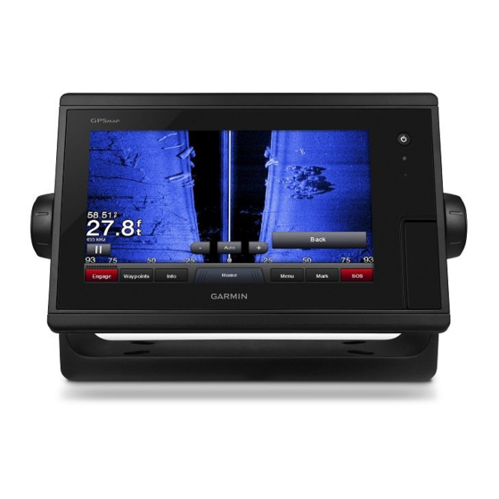
Page 20: Sonar Views
You can set the autopilot to maintain a specific bearing relative to the current wind angle. Your device must be connected to a When properly connected to an optional Garmin sounder NMEA 2000 or NMEA 0183 compatible wind sensor to perform ®... -
Page 21: Sidevü Sonar View
Traditional transducers emit a conical beam. The DownVü To receive Panoptix sonar, you need a compatible chartplotter scanning sonar technology emits a narrow beam, similar to the and a compatible transducer. shape of the beam in a copying machine. This beam provides a ThePanoptix sonar views allow you to see all around the boat in clearer, picture-like image of what is beneath the boat. -
Page 22: Changing The Sonar View
You can view the sonar data from all compatible sources on the RealVü 3D Down Sonar View Garmin Marine Network. You can view sonar data from a This sonar view shows a three-dimensional view of what is compatible external sonar module, such as a GCV sonar ™... -
Page 23: Adjusting The Color Intensity
Setting the Zoom Level on the Sonar Screen by adjusting the brightness for DownVü and SideVü/DownVü transducers. From a sonar view, select Menu > Zoom. If you want to see the highest intensity signal returns on the Select an option: screen, you can lower the gain or brightness to remove lower •... -
Page 24: Selecting Frequencies
Viewing two frequencies concurrently using the split-frequency • To select a different color palette for the bottom, select view allows you to see deeper with the lower frequency return Sonar Setup > Bottom Colors, and select an option. and, at the same time, see more detail from the higher •... -
Page 25: Realvü Sonar Settings
Sonar Appearance Settings Advanced: Configures various sonar display and data source settings (Advanced Sonar Settings). From a sonar view, select Menu > Sonar Setup > Appearance. Installation: Configures the transducer (Transducer Installation Color: Sets the color scheme and color gain. Settings). -
Page 26: Transducer Installation Settings
Narrow beam widths are better for high-speed operation and When you connect your compatible chartplotter to an optional rough sea conditions. They also can improve bottom Garmin marine radar, such as a GMR 1226 xHD2 or a GMR 24 ™... -
Page 27: Changing The Radar Mode
Sentry Changing the Radar Mode mode works with all Garmin GMR model radars. From a combination screen or SmartMode layout with radar, Enabling Timed Transmit select Menu >... -
Page 28: Marpa Targeting Symbols
Removing a MARPA Tag from a Targeted Object From the Radar screen, select a MARPA target. When you connect your chartplotter to an optional Garmin marine radar, you can use the Radar overlay to overlay radar Select MARPA Target > Remove. -
Page 29: Showing The Radar Overlay
compromised, the Radar overlay may not align perfectly with the From a radar screen or the radar overlay, select Menu > chart data. Gain. Select an applicable option for the connected radar: Showing the Radar Overlay • To set the gain automatically once, based on average The radar overlay displays data based on the most recently conditions, the range of the radar signal, and the selected used radar mode. -
Page 30: Echo Trails
Adjusting Sea Clutter on the Radar Screen Automatically NOTE: Not all options and settings are available on all radar and You can set the chartplotter to automatically adjust the chartplotter models. appearance of clutter caused by choppy sea conditions. Turning on Echo Trails NOTE: Depending upon the radar in use, the sea clutter setting From a radar screen or the radar overlay, select Menu >... -
Page 31: Selecting A Different Radar Source
Selecting a Different Radar Source Selecting a higher percentage reduces rudder activity at the expense of heading performance. The higher the percentage, Select an option: the more the course deviates before the autopilot corrects it. • From a radar screen or the radar overlay, select Menu > TIP: In choppy conditions at low speeds, increasing the Radar Setup >... -
Page 32: Setting Up And Following The Zigzag Pattern
Williamson turn pattern was initiated. The Williamson turn If you have a Garmin NMEA 2000 VHF radio connected to your pattern can be used in man overboard situations. chartplotter, these features are also enabled. -
Page 33: Man-Overboard Distress Calls Initiated From A Vhf Radio
Individual Routine Calls For information on placing distress calls from your radio, see the VHF radio owner’s manual. For information about marking an When you connect the chartplotter to a Garmin VHF radio, you MOB or SOS location, see Marking an SOS Location. -
Page 34: Viewing The Gauges
Viewing the Gauges Enabling Some Engine Gauge Status Alarms From the engine gauges screen, select Menu > Gauge Select A/V, Gauges, Controls. Setup > Status Alarms > Custom. Select a gauge. Select one or more engine gauge alarms to turn on or off. Select to view a different gauge page. -
Page 35: Customizing The Close-Hauled Wind Gauge
Select GPS Hdg. or Magnetic. Select Info > Tides & Currents > Tides. NOTE: When moving at low speeds or when stationary, the Current Station Information magnetic compass source is more accurate than the GPS source. NOTE: Current station information is available with certain detailed maps. -
Page 36: Clearing All Of The Messages
Select Info > Warning Manager > Save to Card. Setting Songs to Shuffle From the media screen, select Menu > Shuffle. Clearing all of the Messages If necessary, select an option. Select Info > Warning Manager > Clear Warning Manager. Listening to the Radio Saving a Channel as a Preset Media Player... -
Page 37: Siriusxm Satellite Radio
You can save your favorite channels to the presets list. and all decisions taken with respect to navigating in weather. Garmin will not be responsible for any consequences of using Select Media. SiriusXM weather information. -
Page 38: Weather Warnings And Weather Bulletins
For example, radar is broadcast at five-minute intervals. forecasts, coastal forecasts, and offshore forecasts. Weather When the Garmin receiver is turned on, or when a different bulletins may consist of either weather watches or weather weather feature is selected, the receiver must receive new data advisories. -
Page 39: Viewing Sea Conditions
City Forecasts together show a strong pressure gradient. Strong pressure gradients are associated with areas of stronger winds. City forecasts appear as weather symbols. The forecast is viewed in 12-hour increments. Pressure units are shown in millibars (mb), inches of Mercury (inHg), or hectopascals (hPa). -
Page 40: Selecting A Video Source
Garmin Marine Network. ® weather buoys, county warnings, and hurricane warnings. The Connecting a PoE device directly to a Garmin Marine Network Perspective 3D chart view can show weather radar. chartplotter damages the Garmin chartplotter and may damage Weather overlay settings configured for use on one chart are not the PoE device. -
Page 41: Configuring The Video Appearance
Camera Settings • To pan or tilt the camera, use the compass rose. Some cameras provide additional options to control the camera TIP: Hold in the compass rose to continue to move the view. camera in the desired direction. NOTE: Not all options are available on all camera models and Controlling a Video Camera Using Gestures chartplotter models. -
Page 42: Device Configuration
(if applicable), the software The Safe Depth and Safe Height settings influence how the version for an optional Garmin radar (if applicable), and the unit chartplotter calculates an Auto Guidance line. If an area has an ID number. You may need this information to update the system unknown water depth or an unknown obstacle height, the Auto software or to purchase additional map data information. -
Page 43: Communications Settings
AIS receivers, select NMEA High Speed. Select an option: • To support the input or output of Garmin proprietary data • If the placement of the Auto Guidance line is satisfactory, for interfacing with Garmin software, select Garmin. -
Page 44: Setting Alarms
Enter this value in steps 3 and 4 as a positive easily. You can connect a chartplotter to a Garmin Marine number. Network to receive data from and share data with other Garmin Marine Network-compatible devices and chartplotters. • If the transducer is installed at the bottom of the keel... -
Page 45: Changing The Wireless Channel
Changing the Wireless Channel If the wheel turns freely, check the cable connections. If you continue to get the message, contact Garmin product You can change the wireless channel if you have trouble finding support. or connecting to a device, or if you experience interference. -
Page 46: Waypoints And Routes
Insert a memory card into the card slot. Select GPX. Select Settings > System > System Information > Garmin To transfer data with Garmin devices again, select the ADM file Devices > Save to Card. type. If necessary, select the memory card to save system Copying Data from a Memory Card information to. -
Page 47: Troubleshooting
From Windows Explorer, open the Garmin\scrn folder on the Find out which map datum and position format was used ® memory card. when the original waypoint was created. Copy a .bmp file from the card and paste it to any location on If the original waypoint was taken from a map, there should the computer. -
Page 48: Software License Agreement
“Software”) in binary executable form in the normal operation of the product. Title, ownership rights, and intellectual property rights in and to the Software remain in Garmin and/or its third- party providers. You acknowledge that the Software is the property of Garmin... -
Page 49: Index
VHF 30 fuel onboard 38 Windows phone 30 camera zones 30 configuration 35 memory card 40 Garmin Marine Network 12, 38 controlling 35 detailed maps 40 Garmin product support, contact information 1 home position 35 MOB, device 6 gauges 28 pausing 35 music player 30, 31. See media player engine 28 standby 35 fuel 28 celestial information 29 limits 28... - Page 50 trails 7 timed transmit 21 user data settings 36, 38 deleting 12 radar display 24 synchronizing 12 Perspective 3D 34 system information 36 photos, aerial 5 Shadow Drive, enabling 25 position, tracking 27 vessel trails 7, 27 shoreline distance 11, 37 position report 27 radio 26 SideVü 15 power key 36 calling an AIS target 27 SiriusXM 31 powerboat 2, 12, 39 distress calls 26, 27 Satellite...
- Page 52 +27 (0)11 251 9999 + 46 7744 52020 +886 2 2642-9199 ext 2 +49 (0)180 6 427646 0808 238 0000 20 ct./Anruf. a. d. +44 (0) 870 8501242 deutschen Festnetz, Mobilfunk max. 60 ct./Anruf 913-397-8200 1-800-800-1020 © 2014–2015 Garmin Ltd. or its subsidiaries...