Garmin GPSMAP 751 Owner's Manual
Hide thumbs
Also See for GPSMAP 751:
- Quick start manual (4 pages) ,
- Installation instructions manual (8 pages)

Related Manuals for Garmin GPSMAP 751


Summary of Contents for Garmin GPSMAP 751
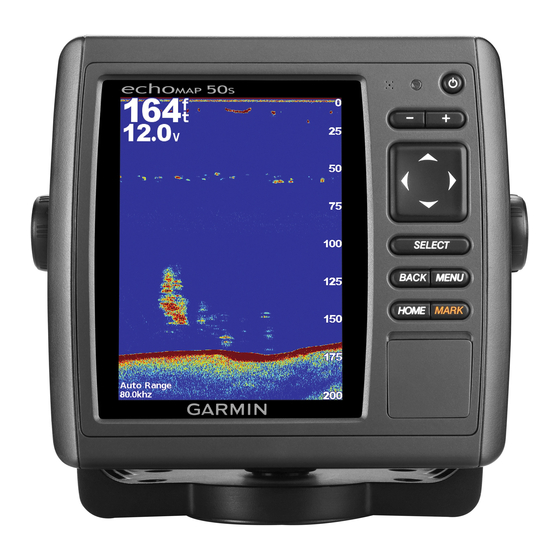
- Page 1 GPSMAP 500/700 Series and echoMAP 50/70 ™ ® Series Owner’s Manual February 2013 190-01556-00_0A Printed in Taiwan...
- Page 2 Garmin ® , the Garmin logo, BlueChart ® , g2 Vision ® , GPSMAP ® , and MapSource ® are trademarks of Garmin Ltd. or its subsidiaries, registered in the USA and other countries.
-
Page 3: Table Of Contents
Table of Contents Marking Your Present Location as a Waypoint ..... 8 Creating a Waypoint at a Different Location ......8 Marking and Navigating to an MOB Location ......8 Introduction..............1 Viewing a List of all Waypoints ..........8 Device Views ................ - Page 4 Viewing Tide Station, Current Station, or Celestial Turning On DSC ..............18 Information for a Different Date ........... 13 DSC List ................... 18 Viewing Information for a Different Tide or Current Station 13 Viewing the DSC List ............18 Viewing Almanac Information from the Navigation Chart ..13 Adding a DSC Contact ............
- Page 5 Setting the Keel Offset ............23 Calibrating a Water Speed Device ........23 Setting the Water Temperature Offset ........ 24 Communications Settings ............24 NMEA 2000 and NMEA 0183 ..........24 NMEA 0183 ..............24 NMEA 2000 ..............24 Communication with Wireless Devices ......24 Connecting a Bluetooth Wireless Device .......
-
Page 7: Introduction
You can use blank memory cards to transfer data such as waypoints, routes, and tracks to another Device Keys compatible Garmin chartplotter or a computer. Turns on and off the device when held. Open the access door on the front of the chartplotter. -
Page 8: Charts And 3D Chart Views
To open the Navigation chart, select Charts > Navigation Chart. Insert the memory card with the label facing to the right. Press the card in until it clicks. To open the Fishing chart, select Charts > Fishing Chart. Close the door. Zooming In and Out of the Chart The zoom level is indicated by the scale number at the bottom Charts and 3D Chart Views... -
Page 9: Viewing Location And Object Information On A Chart
NOTE: Auto Guidance is available with premium charts, in clearance. Carefully compare the course to all visual sightings, some areas. and avoid any land, shallow water, or other obstacles that may be in your path. From the Navigation chart or Fishing chart, select a location. If necessary, select Select. -
Page 10: Showing Satellite Imagery On The Navigation Chart
station indicator, the height of the tide at the station appears When connected to an external AIS device, the chartplotter can above the station indicator. show some AIS information about other vessels that are within range, that are equipped with a transponder, and that are Current direction indicators appear as arrows on the chart. -
Page 11: Showing Ais Vessels On A Chart Or 3D Chart View
When course over ground and heading information are provided alarm will sound 10 minutes before the vessel intersects the by an activated AIS target, but rate of turn information is not safe zone. provided, the projected course of the target is calculated based AIS Distress Signals on the course over ground information. -
Page 12: Navigation And Fishing Chart Setup
Chart Setup: See page Select a layout. Overlay Numbers: See page 6. This might appear in the Select a data field. Chart Setup menu. Select the type of data shown in the field. Chart Appearance: See page 6. This might appear in the Available data options vary based on the chartplotter and Chart Setup menu. -
Page 13: Other Vessels Settings On The Charts And Chart Views
Lane Width: Specifies the width of the navigation lane, which is Basic Navigation Questions the magenta line in some chart views that indicates the Question Answer course to your destination. How do I make the chartplotter point Navigate using Go To. See Other Vessels Settings on the Charts and Chart me in the direction in which I want to page... -
Page 14: Courses
When you start navigation (Go To, Route To, or Guide To), if you are connected through a NMEA 2000 ® network to a Courses compatible Garmin ® autopilot, you are prompted to engage the autopilot. CAUTION Stopping Navigation The Auto Guidance feature is based on electronic chart information. -
Page 15: Deleting A Waypoint Or An Mob
and avoid any land, shallow water, or other obstacles that may Creating and Saving a Route be in your path. This procedure saves the route and all the waypoints in it. The starting point can be your present location or another location. When using Go To, a direct course and a corrected course may pass over land or shallow water. -
Page 16: Deleting A Saved Route
• To navigate the route from the starting point used when Select a track. the route was created, to the right of the original route, Select Edit Track > Save Route. select Forward – Starboard. Browsing for and Navigating a Recorded Track •... -
Page 17: Deleting All Saved Waypoints, Routes, And Tracks
Viewing Engine and Fuel Gauges • To record the track plot based on a variance from your course, select Resolution > Change, and enter the Before you can view engine and fuel gauges, you must be maximum error allowed from the true course before connected to a NMEA 2000 network capable of sensing engine recording a track point. -
Page 18: Setting The Fuel Capacity Of The Vessel
You can display the total amount of fuel on-board either as a Select an option: numeric display that shows the total fuel or as a graphic display • To set the maximum and minimum values that appear that shows the level in each fuel tank. when the upwind close-hauled wind gauge appears, Select Gauges >... -
Page 19: Viewing Tide Station, Current Station, Or Celestial Information For A Different Date
You can adjust the range of the depth scale that appears on the right side of the screen. When properly connected to an optional Garmin sounder module and a transducer, your compatible chartplotter can be From a Sonar view, select Menu > Range. -
Page 20: Turning On The A-Scope
Surface Noise: Hides surface noise to help reduce clutter. When you connect your compatible chartplotter to an optional Garmin marine radar, such as a GMR™ 1206 xHD or a GMR 24 Color Gain: Adjusts the color of sonar returns. HD, you can view more information about your surroundings. -
Page 21: Radar Display Modes
Sentry guard zone in this mode, which identifies a safe zone around mode works with all Garmin GMR model radars. your boat. If you switch from Sentry mode to another mode,... -
Page 22: Marking A Waypoint On The Radar Screen
Marking a Waypoint on the Radar Screen From a Radar screen or the Radar overlay, select a location. When you connect your chartplotter to an optional Garmin marine radar, you can use the Radar overlay to overlay radar Select Create Waypoint. -
Page 23: Manually Adjusting Gain On The Radar Screen
may differ from the automatic gain setting used for another nearby clutter and targets more than it affects the appearance mode. of distant clutter and targets. A higher sea clutter setting reduces the appearance of clutter caused by nearby waves, but NOTE: Depending upon the radar in use, the gain setting it can also reduce or eliminate the appearance of nearby configured for use in one radar mode may or may not be... -
Page 24: Front-Of-Boat Offset
Man-Overboard Distress Calls Initiated from the If you have a Garmin NMEA 2000 VHF radio connected to your chartplotter, these features are also enabled. Chartplotter • The chartplotter allows you to quickly set up and send When your chartplotter is connected to a Garmin NMEA 2000 individual routine call details to your Garmin VHF radio. -
Page 25: Navigating To A Tracked Vessel
72. If you select a different channel, the chartplotter respect to driving or navigating in weather. Garmin will not be uses that channel for subsequent calls until you call using responsible for any consequences of using the weather data. -
Page 26: Siriusxm Equipment And Subscription Requirements
XM WX Satellite Weather data is broadcast at five-minute To view information about the warning or bulletin, select the intervals. When the Garmin receiver is turned on, or when a shaded area. different weather feature is selected, the receiver must receive... -
Page 27: Viewing A Marine Forecast Or An Offshore Forecast
• To view the weather forecast for the previous 12 hours, Wind Barb Wind Speed Wind Barb Wind Speed select Previous Forecast or , and to view previous Calm 20 knots forecasts, up to 48 hours ago, in 12-hour increments, select Previous Forecast or again. -
Page 28: Viewing Forecast Visibility Information For Another Time Period
You can select an area near a buoy to view forecast information. SiriusXM Radio From a weather chart, select a location on the chart. When you have a Garmin SiriusXM receiver connected to the Select Local Weather. chartplotter, you may have access to SiriusXM satellite radio, Select an option: depending on your subscription. -
Page 29: System Settings
You can view the software version, the basemap version, any Select Settings > My Vessel > Keel Offset. supplemental map information (if applicable), the software version for an optional Garmin radar (if applicable), and the unit Select based on the location of the transducer. -
Page 30: Setting The Water Temperature Offset
System: Enables NMEA 0183 output sentences for system The temperature offset compensates for the temperature information. reading from a temperature sensor. Garmin: Enables NMEA 0183 output sentences for Garmin Measure the water temperature using the temperature proprietary sentences. sensor or temperature-capable transducer that is connected Sounder: Enables NMEA 0183 output sentences for the to the chartplotter. -
Page 31: Connecting A Wireless Device To The Chartplotter
Connecting a Wireless Device to the Chartplotter Time Format: Sets a 12-hour, 24-hour, or UTC time format. Before you can connect a wireless device to the chartplotter Time Zone: Sets the time zone, or allows automatic selection wireless network, you must configure the chartplotter wireless based on GPS location. -
Page 32: Adjusting The Distance From Shore
Auto Guidance line using one or supplemental map information (if applicable), the software more familiar destinations that require navigation through a version for an optional Garmin radar (if applicable), and the unit narrow waterway. ID number. You may need this information to update the system software or to purchase additional map data information. -
Page 33: Copying Waypoints, Routes, And Tracks To Or From All Chartplotters On A Nmea 2000 Network
Select an option: Select Settings > System > System Information > Garmin Devices > Save to Card. • To create a new file, select Add New File, and enter a name. Remove the memory card. • To add the information to an existing file, select the file from the list. -
Page 34: Nmea 2000 Pgn Information
Type Sentence Description Type Description GPGGA GGA: Global positioning system 129283 Cross track error fix data 129284 Navigation data GPGLL GLL: Geographic position 129285 Navigation route and waypoint info (latitude and longitude) 129539 GNSS DOPs GPGSA GSA: GNSS DOP and active 129540 GNSS satellites in view satellites Receive... -
Page 35: Index
Index individual routine call 19 turning on 18, 26 navaids 3 distress call 18 navigation alarms 25 distress signal device 5 navigation chart 2, 4, 7, 22 aerial photos 4 DSC. See digital selective calling aerial photos 6 AIS 4, 5, 7 marine service points 7 alarm 5 panning 2 distress signal device 5 EBL 16 radar overlay 16... - Page 36 settings 22–25 water temperature log 14 radar display 17 waypoints 8 system information 23, 26 copying 27 shoreline distance 26 creating 8, 22 SiriusXM 20 deleting 9 SiriusXM Satellite Radio 22 editing 8 software, updating 27 overboard 8 sonar 13 navigating to 8 a-scope 14 radar 16 alarms 14 showing 6 appearance 14 sonar 13 bottom lock 13 tracked vessel 19 cone 7 viewing list of 8 depth 13 weather 22...
- Page 38 1200 East 151st Street Olathe, Kansas 66062, USA Garmin (Europe) Ltd. Liberty House, Hounsdown Business Park Southampton, Hampshire, SO40 9LR UK Garmin Corporation No. 68, Zhangshu 2nd Road, Xizhi Dist. New Taipei City, 221, Taiwan (R.O.C.) © 2013 Garmin Ltd. or its subsidiaries...