Sign In
Upload
Manuals
Brands
Volvo Penta Manuals
Marine Equipment
B9
Volvo Penta B9 Manuals
Manuals and User Guides for Volvo Penta B9. We have
1
Volvo Penta B9 manual available for free PDF download: Owner's Manual
Volvo Penta B9 Owner's Manual (108 pages)
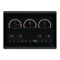
GLASS COCKPIT
Brand:
Volvo Penta
| Category:
Marine Equipment
| Size: 4.1 MB
Table of Contents
Table of Contents
3
Introduction
11
Device Overview
11
Glass Cockpit B7 and Glass Cockpit B9 Connector View
11
Glass Cockpit B12 Connector View
12
Status Icons
12
Using the Touchscreen
12
On-Screen Buttons
12
Tips and Shortcuts
12
Locking and Unlocking the Touchscreen
13
Accessing Owner's Manuals on the Chartplotter
13
Downloading the Manuals from the Web
13
Garmin Support Center
13
Inserting Memory Cards
13
Acquiring GPS Satellite Signals
13
Selecting the GPS Source
13
Customizing the Chartplotter
13
Home Screen
13
Pinning a Feature Button
14
Rearranging the Home Screen
14
Menu Bar
14
Hiding and Showing the Menu Bar
15
Setting the Vessel Type
15
Adjusting the Backlight
15
Adjusting the Color Mode
15
Customizing Pages
15
Customizing the Startup Screen
15
Creating a New Combination Page
15
Adding a Smartmode Layout
16
Customizing the Layout of a Smartmode or Combination Page
16
Deleting a Combination Page
16
Customizing the Data Overlays
16
Linking a Layout to the Control and Joystick Buttons
17
Resetting the Station Layouts
17
Presets
17
Saving a New Preset
17
Managing Presets
17
Controlling the Chartplotter
17
Voice Control
17
Enabling Voice Control
18
Supported Headsets
18
Pairing a Wireless Headset with a Garmin Chartplotter
18
Using a Wireless Headset with a Garmin Chartplotter
18
Chartplotter Voice Commands
18
GRID Remote Control
19
Pairing the GRID Device with the Chartplotter from the Chartplotter
19
Pairing the GRID Device with the Chartplotter from the GRID Device
19
Rotating the GRID Remote Input Device
19
Activecaptain App
19
Activecaptain Roles
19
Getting Started with the Activecaptain App
20
Enabling Smart Notifications
20
Receiving Notifications
20
Managing Notifications
20
Making Notifications Private
21
Updating Software with the Activecaptain App
21
Updating Charts with Activecaptain
21
Chart Subscriptions
21
Purchasing a Chart Subscription with Activecaptain
22
Activating the Chart Subscription Card
22
Downloading Updated Charts
22
Renewing Your Subscription
22
Communication with Wireless Devices
22
Wi-Fi Network
22
Setting up the Wi-Fi Network
22
Connecting a Wireless Device to the Chartplotter
22
Changing the Wireless Channel
23
Changing the Wi-Fi Host
23
Wireless Remote Control
23
Pairing the Wireless Remote Control with the Chartplotter
23
Turning on and off the Remote Backlight
23
Disconnecting the Remote Control from All Chartplotters
23
Wireless Wind Sensor
23
Connecting a Wireless Sensor to the Chartplotter
23
Adjusting the Wind Sensor Orientation
23
Viewing Boat Data on a Garmin Watch
23
Viewing Boat Data on a Garmin Nautix Device
24
Charts and 3D Chart Views
24
Navigation Chart and Fishing Chart
24
Chart Symbols
24
Zooming in and out Using the Touchscreen
25
Measuring a Distance on the Chart
25
Creating a Waypoint on the Chart
25
Viewing Location and Object Information on a Chart
25
Viewing Details about Navaids
25
Navigating to a Point on the Chart
25
Premium Charts
25
Fish Eye 3D Chart View
26
Viewing Tide Station Information
26
Showing Satellite Imagery on the Navigation Chart
27
Viewing Aerial Photos of Landmarks
27
Automatic Identification System
27
AIS Targeting Symbols
27
Heading and Projected Course of Activated AIS Targets
28
Activating a Target for an AIS Vessel
28
Setting the Safe-Zone Collision Alarm
28
Viewing a List of AIS and MARPA Threats
29
AIS Aids to Navigation
29
AIS Distress Signals
29
Turning off AIS Reception
30
Chart Menu
30
Chart Layers
30
Chart Settings
32
Fish Eye 3D Settings
33
Supported Maps
33
Garmin Quickdraw Contours Mapping
33
Mapping a Body of Water Using the Garmin Quickdraw Contours Feature
33
Adding a Label to a Garmin Quickdraw Contours Map
33
Garmin Quickdraw Community
33
Connecting to the Garmin Quickdraw Community with Activecaptain
34
Connecting to the Garmin Quickdraw Community with Garmin Connect
34
Garmin Quickdraw Contours Settings
35
Navigation with a Chartplotter
35
Basic Navigation Questions
36
Route Color Coding
36
Destinations
36
Searching for a Destination by Name
36
Selecting a Destination Using the Navigation Chart
36
Searching for a Marine Services Destination
36
Searching for a Volvo Penta Dealer
36
Setting and Following a Direct Course Using Go to
37
Stopping Navigation
37
Waypoints
37
Marking Your Present Location as a Waypoint
37
Creating a Waypoint at a Different Location
37
Marking a man Overboard (MOB) Location
37
Projecting a Waypoint
37
Viewing a List of All Waypoints
37
Editing a Saved Waypoint
37
Moving a Saved Waypoint
38
Browsing for and Navigating to a Saved Waypoint
38
Deleting a Waypoint or an MOB
38
Deleting All Waypoints
38
Routes
38
Creating and Navigating a Route from Your Present Location
38
Creating and Saving a Route
38
Viewing a List of Routes and Auto Guidance Paths
39
Editing a Saved Route
39
Finding and Navigating a Saved Route
39
Browsing for and Navigating Parallel to a Saved Route
39
Initiating a Search Pattern
39
Deleting a Saved Route
40
Deleting All Saved Routes
40
Auto Guidance
40
Setting and Following an Auto Guidance Path
40
Creating and Saving an Auto Guidance Path
40
Adjusting a Saved Auto Guidance Path
40
Canceling an Auto Guidance Calculation in Progress
40
Setting a Timed Arrival
40
Auto Guidance Path Configurations
40
Tracks
41
Showing Tracks
41
Setting the Color of the Active Track
41
Saving the Active Track
42
Viewing a List of Saved Tracks
42
Editing a Saved Track
42
Saving a Track as a Route
42
Browsing for and Navigating a Recorded Track
42
Deleting a Saved Track
42
Deleting All Saved Tracks
42
Retracing the Active Track
42
Clearing the Active Track
42
Managing the Track Log Memory During Recording
42
Creating a Boundary
43
Converting a Route to a Boundary
43
Converting a Track to a Boundary
43
Editing a Boundary
43
Linking a Boundary to a Smartmode Layout
43
Setting a Boundary Alarm
43
Disabling All Boundary Alarms
43
Deleting a Boundary
43
Deleting All Saved Waypoints, Tracks, Routes, and Boundaries
43
Sailing Features
43
Starting the Race Timer
44
Stopping the Race Timer
44
Setting the Distance between the Bow and the GPS Antenna
44
Laylines Settings
44
Polar Tables
44
Importing a Polar Table Manually
45
Showing Polar Data in Data Fields
45
Setting the Keel Offset
45
Heading Line and Angle Markers
45
Setting the Heading Line and Angle Markers
46
Water Sport Controls
46
Creating a Water Sports User Preset
46
Renaming a User Preset Button
46
Setting the Boat RPM or Speed
46
Setting the Speed Source
46
Adjusting the Trim Tabs
46
Adjusting the Power Trim
46
Adjusting the Ballast Tank Levels
46
Ballast Tank Tips
47
Adjusting Ballast Tank Drain and Fill Times
47
Turning on the Trim Assist Feature
47
Adjusting the Boat Load
47
Sonar Fishfinder
47
Stopping the Transmission of Sonar Signals
47
Traditional Sonar View
47
Split-Frequency Sonar View
47
Split-Zoom Sonar View
48
Garmin Clearvü Sonar View
48
Garmin Sidevü Sonar View
48
Sidevü Scanning Technology
48
Measuring Distance on the Sonar Screen
48
Panoptix Sonar Views
48
Livevü down Sonar View
49
Livevü Forward Sonar View
49
Realvü 3D Forward Sonar View
49
Realvü 3D down Sonar View
49
Realvü 3D Historical Sonar View
50
Frontvü Sonar View
50
Livescope Sonar View
50
Perspective View
50
Selecting the Transducer Type
50
Selecting a Sonar Source
51
Renaming a Sonar Source
51
Creating a Waypoint on the Sonar Screen
51
Pausing the Sonar Display
51
Viewing Sonar History
51
Sonar Sharing
51
Zooming in a Panoptix Livevü or Livescope Sonar View
51
Adjusting the Level of Detail
52
Adjusting the Color Intensity
52
Sonar Setup
52
Setting the Zoom Level on the Sonar Screen
53
Setting the Scroll Speed
53
Adjusting the Range
53
Sonar Noise Rejection Settings
53
Sonar Appearance Settings
54
Sonar Alarms
54
Advanced Sonar Settings
55
Transducer Installation Settings
55
Sonar Frequencies
55
Turning on the A-Scope
56
Panoptix Sonar Setup
56
Adjusting the Realvü Viewing Angle and Zoom Level
56
Adjusting the Realvü Sweep Speed
56
Livevü Forward and Frontvü Sonar Settings
56
Realvü Appearance Settings
57
Panoptix Transducer Installation Settings
58
Livescope and Perspective Sonar Settings
58
Livescope and Perspective Sonar Setup
59
Livescope and Perspective Appearance Settings
59
Livescope and Perspective Layout Settings
59
Livescope and Perspective Transducer Installation Settings
60
Radar
60
Radar Interpretation
60
Radar Overlay
60
Radar Overlay and Chart Data Alignment
60
Transmitting Radar Signals
61
Stopping the Transmission of Radar Signals
61
Setting up the Timed Transmit Mode
61
Enabling and Adjusting a Radar no Transmit Zone
61
Adjusting the Radar Range
61
Tips for Selecting a Radar Range
61
Motionscope™ Doppler Radar Technology
61
Enabling a Guard Zone
62
Defining a Circular Guard Zone
62
Defining a Partial Guard Zone
62
Marpa
62
MARPA Targeting Symbols
62
Acquiring MARPA Targets Automatically
62
Removing MARPA Targets Automatically
62
Assigning a MARPA Tag to an Object
63
Removing a MARPA Tag from a Targeted Object
63
Viewing Information about a MARPA-Tagged Object
63
Viewing a List of AIS and MARPA Threats
63
Showing AIS Vessels on the Radar Screen
63
VRM and EBL
63
Echo Trails
63
Turning on Echo Trails
63
Adjusting the Length of the Echo Trails
63
Clearing the Echo Trails
64
Radar Settings
64
Radar Gain
64
Radar Filter Settings
64
Radar Options Menu
65
Radar Setup Menu
65
Radar Appearance Settings
65
Radar Installation Settings
66
Radar My Vessel Layer Settings
66
Selecting a Different Radar Source
66
Autopilot
66
Autopilot Configuration
66
Selecting the Preferred Heading Source
66
Selecting the DPS Antenna as the Preferred Autopilot Heading Source
67
Opening the Autopilot Screen
67
Autopilot Screen
67
Adjusting the Step Steering Increment
67
Setting the Power Saver
67
Enabling Shadow Drive
67
Autopilot Overlay Bar
67
Engaging the Autopilot
67
Wave Height, Wave Period, and Wave Direction
85
Viewing Forecast Sea Conditions Information for Another Time Period
85
Viewing Sea Temperature Information
85
Surface Pressure and Water Temperature Data
85
Changing the Sea Surface Temperature Color Range
85
Visibility Information
85
Viewing Forecast Visibility Information for Another Time Period
85
Viewing Buoy Reports
85
Viewing Local Weather Information Near a Buoy
85
Weather Overlay
86
Viewing Weather Subscription Information
86
Viewing Video
86
Selecting a Video Source
86
Alternating Among Multiple Video Sources
86
Networked Video Devices
86
Using Video Presets on Networked Video Cameras
86
Camera Settings
86
Video Settings
87
Associating the Camera to a Video Source
87
Video Camera Movement Control
87
Configuring the Video Appearance
87
Garmin VIRB Action Cameras
88
Connecting a VIRB 360 Action Camera
88
Connecting a VIRB Action Camera
88
Controlling the VIRB Action Camera with the Chartplotter
88
Adding the VIRB Action Camera Controls to Other Screens
89
HDMI out Video Considerations
89
Pairing the GC™ 100 Camera with a Garmin Chartplotter
89
Surround View Camera System
90
Changing a Camera
90
Viewing a Camera Feed Full Screen
90
Changing the Surround View Camera Layout
90
Showing and Hiding the Visual Bumper
91
Adjusting the Visual Bumper
91
Showing the Distance Marker
91
Renaming a Camera
91
Device Configuration
91
System Settings
91
Sounds and Display Settings
91
GPS Settings
91
Station Settings
92
Viewing System Software Information
92
Viewing E-Label Regulatory and Compliance Information
92
Preferences Settings
92
Units Settings
92
Navigation Settings
92
Communications Settings
93
NMEA 0183 Settings
93
NMEA 2000 Settings
94
Marine Network
94
EVC Network
94
Setting Alarms
94
Navigation Alarms
94
System Alarms
95
Sonar Alarms
95
Setting Weather Alarms
95
Setting the Fuel Alarm
95
My Vessel Settings
95
Setting the Keel Offset
96
Setting the Water Temperature Offset
96
Setting the Exhaust Aftertreatment System (EATS) Mode
97
Calibrating a Water-Speed Device
97
Adding a Key
97
Setting the Speed Factor
97
Fuel Tank Settings
97
Seven Marine Engine Installation Settings
97
Other Vessels Settings
98
Settings that Are Synced on the Garmin Marine Network
98
Restoring the Original Chartplotter Factory Settings
98
Sharing and Managing User Data
98
Selecting a File Type for Third-Party Waypoints and Routes
99
Copying User Data from a Memory Card
99
Copying User Data to a Memory Card
99
Updating Built-In Maps with a Memory Card and Garmin Express
99
Backing up Data to a Computer
99
Restoring Backup Data to a Chartplotter
99
Saving System Information to a Memory Card
99
Appendix
100
Activecaptain and Garmin Express
100
Garmin Express App
100
Installing the Garmin Express App on a Computer
100
Registering Your Device Using the Garmin Express App
100
Updating Your Charts Using the Garmin Express App
101
Software Updates
101
Cleaning the Screen
102
Viewing Images on a Memory Card
102
Screenshots
102
Capturing Screenshots
102
Copying Screenshots to a Computer
102
Troubleshooting
102
My Device will Not Acquire GPS
102
Signals
102
My Device will Not Turn on or Keeps Turning off
102
My Device Is Not Creating Waypoints in the Correct Location
103
Contacting Volvo Penta Support
103
Specifications
103
Glass Cockpit B7 Specifications
103
Glass Cockpit B9 Specifications
103
Glass Cockpit B12 Specifications
104
Sonar Models Specifications
105
NMEA 2000 PGN Information
105
NMEA 0183 Information
106
J1939 Information
106
Advertisement
Advertisement
Related Products
Volvo Penta B7
Volvo Penta B12
Volvo Penta BWV
Volvo Penta BB231
Volvo Penta BB261
Volvo Penta 5.7 Gil-B
Volvo Penta 5.7 Gil-C
Volvo Penta 5.7 GXil-C
Volvo Penta 5.7 GXil-D
Volvo Penta 8.1 Gil-B
Volvo Penta Categories
Engine
Outboard Motor
Control Systems
Marine Equipment
Boat
More Volvo Penta Manuals
Login
Sign In
OR
Sign in with Facebook
Sign in with Google
Upload manual
Upload from disk
Upload from URL