Sign In
Upload
Manuals
Brands
Magellan Manuals
GPS
NAV 6500
Magellan NAV 6500 Manuals
Manuals and User Guides for Magellan NAV 6500. We have
1
Magellan NAV 6500 manual available for free PDF download: User Manual
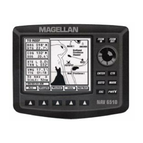
Magellan NAV 6500 User Manual (114 pages)
Magellan GPS Kit User Manual NAV 6500, NAV 6510
Brand:
Magellan
| Category:
GPS
| Size: 0.98 MB
Table of Contents
Table of Contents
5
Packing List
9
Conventions Used in this Manual
10
Commonly Used Terms
10
Getting Started
11
Magellan NAV 6500/NAV 6510 Description
11
Adjusting Contrast
13
Power ON/OFF
13
Adjusting Backlighting
14
First Time Use - Initializing the Receiver
14
Navigating with Your Receiver
16
Reference
17
Adjusting Contrast
17
Cancelling an Operation
17
General Usage
17
Inputting Data
17
Turning the Receiver ON/OFF
17
Adjusting Backlighting
18
NAV Screens
18
Satellite Status Screen
18
Map Screen
20
Setting the Map Scale
21
Using the Cursor Key on the Map Screen
21
Map Orientation
22
Track Plot Mode
23
Viewing Nav-Aid Attributes
23
Finding Distance & Bearing from a Point on the Map
25
Viewing Tide Information
26
Viewing Port Information
26
NAV 1 Screen
27
NAV 2 Screen
27
Customizing the Nav 2 Screen
28
Waypoints
28
Creating a Waypoint
29
Saving the Cursor Position as a Waypoint
29
Saving the Current Position Fix as a Waypoint
29
Modifying Waypoint Data Fields
30
Creating a Waypoint Using the MARK Key
30
Accessing the Waypoint List
31
Finding a Waypoint in the Waypoint List
31
Viewing a Waypoint from the Waypoint List
32
Editing a Waypoint from the Waypoint List
32
Deleting a Waypoint from the Waypoint List
33
Deleting All Waypoints in the Waypoint List
33
Creating a Waypoint from the Waypoint List
33
Viewing Nearest Waypoint
34
Deleting a Waypoint from the Map Screen
34
Moving a Waypoint
34
Routes
35
Creating a GOTO Route from Waypoint List
35
Creating a GOTO Route from Nearest List
36
Creating a GOTO Route by Waypoint Name
36
Creating a GOTO Route to the Cursor Position
37
Creating a MOB Route
37
Deleting a GOTO Route
37
Multi-Leg Routes
38
Creating a Multi-Leg Route Using the Map
38
Creating a Multi-Leg Route (Text Mode)
38
Activating a Route
39
Deactivating a Route
40
Reversing a Route from the Map Screen
40
Reversing a Route from the List
41
Editing a Route
41
Inserting a Waypoint in a Route
41
Removing a Waypoint from a Route
42
Appending a Waypoint to the End of a Route
42
Moving a Waypoint in a Route
43
Replacing a Waypoint in a Route Using Text Edit
43
Activating a Leg of a Route
44
Deleting a Route on the Map
45
Deleting a Route in the List
45
Copying a Route
45
Auxiliary Functions
46
The Aux Screen
46
General Setup Function
46
Adjusting Contrast
47
Setting Time Reference
47
Initializing Date/Time
47
Setting Time Format
48
Setting Date Format
48
Turning the Beeper on or off
48
Language Setting
48
Navigation Setup
49
Selecting Coordinate System
49
Selecting Map Datum
50
Selecting North Reference
50
Selecting Map Orientation
50
Setting Projected Course
51
NAV 2 Screen Setup
51
CDI/Units/Alarms Function
51
Selecting CDI Scale
52
Setting Distance Units
52
Setting Speed Units
52
Setting Depth Units
52
Activating Alarms
53
Setting Arrival Radius
53
Setting Anchor Alarm
53
Setting XTE Alarm
54
Turning Test Alarm on or off
54
Data Port Setup Functions
54
Setting NMEA Output
54
Changing NMEA Output Baud Rate
55
Turning NMEA Input on or off
55
Changing NMEA Input Baud Rate
55
Setting Differential Input Baud Rate
55
Map Configuration Functions
56
Turning Land Settings on and off
56
Turning Marine Settings on and off
56
Bathymetric Lines
57
Depth Areas Limit
57
Bathymetrics and Soundings Range
58
Turning Nav-Aid Settings on and off
58
Lights
59
Turning Other Settings on and off
59
Turning Chart Settings on and off
59
Plotter Mode
60
Track History Functions
60
Turning Track History on or off
61
Choosing Plotting Interval
61
Resolution by Dist
61
Resolution by Time
61
Percentage of Track Memory Used
61
Clearing Track Memory
62
Trip Planning Function
62
Calculator
62
Calculating Sunrise/Sunset and Lunar Information
63
Calculating Actual Current
63
Simulation Mode Function
64
Memory Reset
64
Color Setup
64
User C-Card
65
Map Shift
66
Troubleshooting
68
Warnings/Alarms
70
Tutorial
71
NAV 6500/NAV 6510 Appendix
77
Installation Instructions
77
Gimbal Mount Installation Instructions
78
Flush Mount Installation Instructions
80
Proper Antenna Installation - Signal Reception
82
Electrical Connections
82
Wiring Instructions
83
Navaid Icons
84
Nav-Aid Icons
84
Data Cartridges
89
List of Available Datums
90
NMEA Messages
91
Abbreviations
98
Specifications
100
Coordinate Systems
101
What Is GPS
103
Explanation of Data Terms
105
Glossary
107
Index
110
Advertisement
Advertisement
Related Products
Magellan GPS Satellite Navigator NAV 1200XL
Magellan NAV6000
Magellan NAV 6510
Magellan NAV 5200DX
Magellan NAV 5000
Magellan NAV 1200XL
Magellan NAV 1000 PLUS
Magellan N630
Magellan RoadMate N393M Series
Magellan N476
Magellan Categories
GPS
Car Navigation system
Security System
Keypad
Receiver
More Magellan Manuals
Login
Sign In
OR
Sign in with Facebook
Sign in with Google
Upload manual
Upload from disk
Upload from URL