Sign In
Upload
Manuals
Brands
Garmin Manuals
GPS
GPSMAP 190-01155-00
Garmin GPSMAP 190-01155-00 Manuals
Manuals and User Guides for Garmin GPSMAP 190-01155-00. We have
1
Garmin GPSMAP 190-01155-00 manual available for free PDF download: Owner's Manual
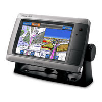
Garmin GPSMAP 190-01155-00 Owner's Manual (100 pages)
Garmin Chartplotter Owner's Manual
Brand:
Garmin
| Category:
GPS
| Size: 7 MB
Table of Contents
Introduction
3
Manual Conventions
3
Tips and Shortcuts
3
Table of Contents
4
Front and Back Panels
5
Getting Started
5
Turning off the Chartplotter
5
Turning on the Chartplotter
5
Adjusting the Backlight
6
Adjusting the Color Mode
6
GPS Satellite Signal Acquisition
6
Initial Chartplotter Settings
6
Inserting and Removing Data and Memory Cards
6
About the Home Screen
7
Viewing System Information
7
Charts and 3D Chart Views
8
Navigation Chart
8
Chart Symbols
9
Navigating to a Point on the Chart
9
Viewing Tide Station Information
11
Viewing Details about Navaids
12
Heading Line
13
Automatic Identification System
16
Perspective 3D
19
Bluechart G2 Vision
20
Mariner's Eye 3D
21
Fish Eye 3D
22
Fishing Chart
23
Showing Satellite Imagery on the Navigation Chart
24
Viewing Aerial Photos of Landmarks
24
Animated Tide and Current Indicators
25
Auto Guidance
25
Detailed Road and Point of Interest Data
25
About the Combination Screen
26
Combination Screen Configuration
26
Combinations
26
Configuration
26
Basic Navigation Questions
29
Navigation
29
Navigation with a Chartplotter
29
Waypoints
30
Routes
32
Creating and Saving a Route
33
Editing a Saved Route
33
Tracks
34
Navigating with a Garmin Autopilot
36
Marine Services Destinations
37
Where to
37
Almanac Data
40
Almanac, On-Boat, and Environmental Data
40
Current Information
41
Current Station Information
41
On-Boat Data
42
Environmental Data
45
Basic Device Configuration Questions
48
Device Configuration
48
Simulator Mode
48
Turning the Chartplotter on Automatically
48
Display Configuration
49
Navigation Preferences
49
Coordinate Systems
51
Information about Your Boat
54
Alarms
55
Chartplotter Data Management
56
Backing up Data to a Computer
57
Restoring Backup Data to a Chartplotter
57
Adjusting the Zoom Scale on the Radar Screen
58
Radar
58
Transmitting Radar Signals
58
Radar Display Modes
59
Sentry Mode
61
Waypoints and Routes on the Radar Screen
64
About the Radar Overlay
65
Optimizing the Radar Display
66
Radar Display Appearance
70
Radar Display Settings
71
Radar Overlay Display Appearance
73
Sonar
75
Sonar Views
75
Depth Log
77
Transducer Temperature Log
77
Sonar Display Appearance
78
Waypoints on the Sonar Screen
78
Configuring the Appearance of Suspended Targets
79
Selecting Frequencies
80
Sonar Alarms
81
Transducer Configuration
82
About the DSC List
83
Chartplotter and VHF Radio Functionality
83
Digital Selective Calling
83
Turning on DSC
83
Incoming Distress Calls
84
Man-Overboard Distress Calls Initiated from a VHF Radio
84
Man-Overboard Distress Calls Initiated from the Chartplotter
84
Position Tracking
85
Individual Routine Calls
87
Making an Individual Routine Call to an AIS Target
87
Appendix
88
Calibrating the Touchscreen
88
Specifications
88
Screenshots
89
System Information
89
Using WAAS/EGNOS
89
Viewing GPS Satellite Locations
89
NMEA 0183 and NMEA 2000
90
Agreement
93
Contacting Garmin Product Support
93
Declaration of Conformity
93
Registering Your Device
93
Software License Agreement
93
Index
94
Advertisement
Advertisement
Related Products
Garmin 190-01219-90
Garmin Oregon 190-01070-00
Garmin GPSMAP 190-01155-02
Garmin 190-00556-10
Garmin GPSMAP 190-00683-00
Garmin GPSMAP 190-00557-00
Garmin GPSMAP 192C
Garmin GPSMAP 195
Garmin GPSMAP GPSMAP 196
Garmin GPS 19x NMEA 0183
Garmin Categories
GPS
Watch
Car Navigation system
Avionics Display
Marine Equipment
More Garmin Manuals
Login
Sign In
OR
Sign in with Facebook
Sign in with Google
Upload manual
Upload from disk
Upload from URL