Sign In
Upload
Manuals
Brands
Garmin Manuals
GPS
aera 796
Garmin aera 796 Manuals
Manuals and User Guides for Garmin aera 796. We have
5
Garmin aera 796 manuals available for free PDF download: Pilot's Manual, Quick Reference Manual, Specifications
Garmin aera 796 Pilot's Manual (252 pages)
Brand:
Garmin
| Category:
GPS
| Size: 7.07 MB
Table of Contents
Table of Contents
13
Section 1 Overview
17
Unit Overview
17
Getting Started
18
Battery Installation
18
Charging the Battery
19
Mounting the Aera 795/796 in the Aircraft
20
Turning the Unit On/Off
20
GPS Receiver Status
22
Acquiring Satellites
23
Satellite Information
23
Display Orientation
24
Operation
24
Basic Touchscreen Operation
24
Dedicated Icons
26
Page Buttons (Optional)
26
Main Menu
27
Menus and Data Entry
31
Option Menus
31
Data Entry
31
Using Map Displays
34
Map Range
34
Auto Zoom
35
Map Panning
36
Map Overlays
38
Map Symbols
38
System Settings
39
Display
40
Sound
42
Additional Settings
43
Nearest Airport Criteria Settings
44
Present Position
45
Position
45
New Location
45
Simulator Mode
46
Section 2 Gps Navigation
47
Introduction
47
Data Fields
48
Gps Navigation
49
Data Field Options
50
Numeric Flight Data
51
Compass Arc
52
Hsi/Panel
53
Setting the Bug Indicator
54
Manually Setting a Course
54
Vertical Navigation (VNAV)
55
Using the VNAV Feature
56
Table of Contents
58
Map Display Setup
58
Map Orientation
59
Airports, Navaids, Cities & Roads
59
Airways
60
Waypoints
61
Waypoint Information
62
Waypoint Frequencies
64
Waypoint Weather and NOTAM Information
64
Airport Directory Waypoint Information
65
Viewing Chart Information by Identifier
66
Nearest Information
66
Textual Weather and NOTAM Information
69
Accessing Additional Information
71
Creating User Waypoints
74
Deleting User Waypoints
75
Select a City
76
Direct-To Navigation
80
Section 3 Flight Planning
83
Introduction
83
Data Fields
84
Flight Plan Creation
85
Flight Planning
86
Adding Waypoints to an Existing Flight Plan
87
Graphical Flight Planning
87
Flight Plan Storage
90
Flight Plan Activation
90
Flight Plan Editing
91
Editing Speed and Fuel Flow
91
Copying Flight Plans
92
Deleting Flight Plans
92
Inverting a Flight Plan
93
Importing/Exporting Flight Plans
94
Approaches
94
Selecting an Approach
95
Section 4 Hazard Avoidance
99
Weather
99
Sxm
100
Hazard Avoidance
100
Winds Aloft
104
Storm Cells
105
Freezing Level
110
Using S Irius XM Satellite Weather Products
113
Data Link Weather (FIS-B) (795 and 796)
117
Nexrad Abnormalities
120
Using FIS-B Weather Products
128
Terrain
132
Terrain Information
133
Obstacle Information
133
Terrain and Obstacle Color Code
134
Terrain Views
134
Terrain Alerts & Setup
135
Traffic
138
Traffic Information Service (TIS-A)
139
Traffic Warning Window
140
Data Link Traffic (GDL 39)
142
System Status
145
Traffic Description
146
Symbol Description
146
Section 5 Additional Features
155
Vision
156
Vision Operation
157
Airport Directory Data
159
Chartview
161
Aircraft Symbol
163
Chart Range
164
Jeppesen Database-Published Notams
164
Flitecharts
165
Aircraft Symbol
168
Flitechart Range
169
Flitecharts Cycle Number and Expiration Date
169
VFR/IFR Chart Viewing
170
Safetaxi
171
Safetaxi Cycle Number and Revision
172
Siriusxm ® Radio (Aera 796)
172
Activating Siriusxm Satellite Radio Services
173
Using Siriusxm Radio
174
Electronic Checklists
178
Section 6 Appendices
179
Appendix A: Messages, Alerts & Data Field Options
179
Miscellaneous Message Advisories
179
Airspace Messages
181
Data Field & Numeric Data Options
181
Aural Alerts
183
Appendix B: Abnormal Operation
185
Loss of GPS Position
185
Hazard Display with Loss of GPS Position
185
Appendix C: SD Cards and Databases
186
SD Card Use
186
Databases
187
Appendix D: Installation and Interfacing
193
Mounting the Aera 795/796 in the Aircraft
193
Connecting to a Computer
197
Interfacing
198
Connecting to a Garmin VHF Comm Radio
200
Connecting the GXM 40 Antenna (Aera 796)
202
Connecting to a GTX 330 Mode S Transponder
203
Table of Contents
204
Connecting to a GDL 39
204
Using an External GPS Antenna (Optional)
205
Appendix E: Battery and Care Information
207
Battery Information
207
Changing the Cigarette Lighter Adapter Fuse
207
Cleaning the Casing
208
Cleaning the Touchscreen
208
Protecting the Unit
208
Appendix F: General TIS-A Information
209
TIS-A Vs. TAS/TCAS
209
TIS-A Limitations
209
Appendix G: Utilities
213
Document Viewer
213
Scratch Pad
213
Flight Log
214
Track Log
216
Heading Line
219
E6B Calculator
220
Aircraft Profile
222
Weight & Balance
224
Proximity Waypoints
226
Appendix H: Display Symbols
229
VFR Symbols
229
IFR Symbols
230
Airspace Symbols
232
Appendix I: Map Datum and Location Formats
235
Map Datums
235
Location Formats
235
Appendix J: Glossary
237
Appendix K: License Agreement and Warranty
243
Contact Garmin
243
Software License Agreement
243
Limited Warranty
243
AOPA Airport Directory Notice
244
Ac-U-Kwik License Agreement
244
S Irius XM Satellite Radio Service Agreement
245
Weather Data Warranty
245
FCC Compliance
246
Industry Canada Compliance
246
Index
247
Advertisement
Garmin aera 796 Pilot's Manual (210 pages)
Brand:
Garmin
| Category:
GPS
| Size: 6.2 MB
Table of Contents
Table of Contents
11
Section 1 Overview
15
Unit Overview
15
Getting Started
16
Battery Installation
16
Charging the Battery
17
Mounting the Aera 795/796 in the Aircraft
18
Turning the Unit On/Off
19
GPS Receiver Status
20
Acquiring Satellites
21
Satellite Information
21
Display Orientation
22
Operation
22
Basic Touchscreen Operation
22
Dedicated Icons
24
Page Buttons (Optional)
24
Main Menu
25
Menus and Data Entry
29
Option Menus
29
Data Entry
29
Using Map Displays
32
Map Range
32
Auto Zoom
33
Map Panning
34
Map Overlays
36
Map Symbols
36
System Settings
37
Display
38
Sound
40
Additional Settings
41
Nearest Airport Criteria Settings
42
Present Position
42
Position
42
New Location
43
Simulator Mode
43
Section 2 GPS Navigation
45
Introduction
45
Data Fields
46
Gps Navigation
47
Data Field Options
48
Numeric Flight Data
49
Compass Arc
50
Hsi/Panel
51
Setting the Bug Indicator
52
Manually Setting a Course
52
Vertical Navigation (VNAV)
53
Using the VNAV Feature
54
Table of Contents
56
Map Display Setup
56
Map Orientation
57
Airports, Navaids, Cities & Roads
57
Airways
58
Waypoints
58
Waypoint Information
59
Waypoint Frequencies
61
Waypoint Weather Information
62
Airport Directory Waypoint Information
62
Viewing Chart Information by Identifier
63
Nearest Information
64
Textual Weather Information
66
Accessing Additional Information
68
Creating User Waypoints
71
Deleting User Waypoints
72
Select a City
73
Direct-To Navigation
77
Section 3 Flight Planning
79
Introduction
79
Data Fields
80
Flight Plan Creation
81
Flight Planning
82
Adding Waypoints to an Existing Flight Plan
83
Flight Plan Storage
84
Flight Plan Activation
84
Flight Plan Editing
85
Editing Speed and Fuel Flow
85
Copying Flight Plans
86
Deleting Flight Plans
86
Inverting a Flight Plan
87
Importing/Exporting Flight Plans
88
Approaches
88
Selecting an Approach
89
Activating Vectors-To-Final
91
Section 4 Hazard Avoidance
93
Sxm
93
Activating Services
93
S Irius XM Satellite Weather Products
94
Hazard Avoidance
95
Winds Aloft
97
Storm Cells
98
Freezing Levels
103
Surface Pressure
105
Using S Irius XM Satellite Weather Products
106
Terrain
109
Terrain Information
110
Obstacle Information
110
Terrain and Obstacle Color Code
111
Terrain Views
112
Terrain Alerts & Setup
113
Traffic Information Service (TIS)
115
TIS Symbology
115
TIS Alerts
116
Traffic Ground Track
117
Displaying Traffic Data
117
Section 5 Additional Features
119
Vision
120
Vision Operation
121
Additional Features
122
Airport Directory Data
123
Chartview
125
Aircraft Symbol
126
Chart Range
127
Jeppesen Database-Published Notams
127
Flitecharts
128
Aircraft Symbol
130
Flitechart Range
130
Flitecharts Cycle Number and Expiration Date
131
VFR/IFR Chart Viewing
131
Safetaxi
132
Safetaxi Cycle Number and Revision
133
Siriusxm ® Radio (Aera 796)
133
Activating Siriusxm Satellite Radio Services
134
Using Siriusxm Radio
135
Using Favorites
137
Adjusting the Volume
139
Electronic Checklists
140
Section 6 Appendices
141
Appendix A: Messages, Alerts & Data Field Options
141
Miscellaneous Message Advisories
141
Airspace Messages
143
Data Field & Numeric Data Options
143
Aural Alerts
145
Appendix B: Abnormal Operation
147
Loss of GPS Position
147
Hazard Display with Loss of GPS Position
147
Appendix C: SD Cards and Databases
148
SD Card Use
148
Databases
149
Appendix D: Installation and Interfacing
153
Mounting the Aera 795/796 in the Aircraft
153
Connecting to a Computer
157
Table of Contents
158
Connecting to a Garmin VHF Comm Radio
158
Connecting the GXM 40 Antenna (Aera 796)
160
Connecting to a GTX 330 Mode S Transponder
161
Interfacing
161
Using an External GPS Antenna (Optional)
163
Appendix E: Battery and Care Information
165
Battery Information
165
Changing the Cigarette Lighter Adapter Fuse
165
Cleaning the Casing
166
Cleaning the Touchscreen
166
Protecting the Unit
166
Appendix F: General TIS Information
167
TIS Vs. TAS/TCAS
167
TIS Limitations
167
Appendix G: Utilities
171
Document Viewer
171
Scratch Pad
171
Flight Log
172
Track Log
174
Heading Line
177
E6B Calculator
178
Aircraft Profile
180
Weight & Balance
182
Proximity Waypoints
184
Appendix H: Display Symbols
187
VFR Symbols
187
IFR Symbols
188
Airspace Symbols
190
Appendix I: Map Datum and Location Formats
193
Map Datums
193
Location Formats
193
Appendix J: Glossary
195
Appendix K: License Agreement and Warranty
201
Contact Garmin
201
Software License Agreement
201
Limited Warranty
201
AOPA Airport Directory Notice
202
S Irius XM Satellite Radio Service Agreement
202
Weather Data Warranty
203
FCC Compliance
204
Industry Canada Compliance
204
Garmin aera 796 Quick Reference Manual (70 pages)
Brand:
Garmin
| Category:
GPS
| Size: 1.65 MB
Table of Contents
Table of Contents
7
Section 1 Overview
9
Unit Overview
9
Getting Started
10
Battery Installation
10
Charging the Battery
12
GPS Receiver Status
12
Display Orientation
12
Operation
13
Basic Touchscreen Operation
13
Dedicated Icons
15
Page Buttons (Optional)
15
Main Menu
16
Menus and Data Entry
20
Option Menus
20
Data Entry
20
Using Map Displays
22
Map Range
22
Map Panning
23
Panning the Map
24
Map Overlays
26
Bluetooth
26
Section 2 Gps Navigation
27
Flight Data
27
Data Fields
27
Numeric Flight Data
27
Hsi/Panel
28
Setting the Bug Indicator
28
Manually Setting a Course
28
Vertical Navigation (VNAV)
29
Using the VNAV Feature
29
Waypoints
30
Nearest Information
31
Textual Weather and NOTAM Information
31
Gps Navigation
32
User Waypoints
33
Direct-To Navigation
33
Section 3 Flight Planning
35
Flight Plan Data Fields
35
Flight Plan Creation
35
Flight Planning
36
Adding Flight Plan Waypoints
37
Graphical Flight Planning
37
Flight Plan Storage
40
Table of Contents
40
Flight Plan Activation
40
Flight Plan Deletion
41
Approaches
41
Section 4 Hazard Avoidance
45
Weather
45
Siriusxm Weather (Aera 796 Only)
45
Data Link Weather (FIS-B) (795 and 796)
45
Hazard Avoidance
46
Terrain
47
Traffic
47
Traffic Information Service (TIS-A)
48
Data Link Traffic (GDL 39)
48
System Status
49
Section 5 Utilities
53
Flight Log
53
Track Log
53
E6B Calculator
54
Aircraft Profile
55
Weight & Balance
56
Section 6 Appendix
57
Miscellaneous Message Advisories
57
Airspace Messages
58
Data Field & Numeric Data Options
59
Aural Alerts
61
Loss of GPS Position
61
Hazard Display with Loss of GPS Position
62
License Agreement and Warranty
62
AOPA Airport Directory Notice
63
Ac-U-Kwik License Agreement
64
S Irius XM Satellite Radio Service Agreement
64
Weather Data Warranty
64
FCC Compliance
66
Industry Canada Compliance
66
Index
67
Advertisement
Garmin aera 796 Quick Reference Manual (60 pages)
Brand:
Garmin
| Category:
GPS
| Size: 1.09 MB
Table of Contents
Table of Contents
9
Section 1 Overview
11
Unit Overview
11
Getting Started
12
Battery Installation
12
Charging the Battery
14
GPS Receiver Status
14
Display Orientation
14
Operation
15
Dedicated Icons
15
Page Buttons
15
Main Menu
16
Basic Touchscreen Operation
20
Menus and Data Entry
21
Option Menus
21
Data Entry
22
Using Map Displays
23
Map Panning
23
Map Range
25
Map Overlays
25
Section 2 GPS Navigation
27
Flight Data
27
Data Fields
27
Numeric Flight Data
27
Hsi/Panel
28
Setting the Bug Indicator
28
Manually Setting a Course
28
Vertical Navigation (Vnav)
29
Using the VNAV Feature
29
Waypoints
30
Nearest Information
31
Weather Information (Aera 796)
31
User Waypoints
31
Direct-To Navigation
32
Gps Navigation
33
Section 3 Flight Planning
35
Flight Plan Data Fields
35
Flight Plan Creation
35
Adding Flight Plan Waypoints
36
Flight Plan Storage
37
Flight Plan Activation
38
Flight Plan Deletion
38
Approaches
39
Flight Planning
40
Table of Contents
41
Section 4 Hazard Avoidance
41
S Irius XM ® Weather (Aera 796)
41
Terrain
41
Traffic Information Service (Tis)
42
Section 5 Utilities
43
Flight Log
43
Track Log
43
E6B Calculator
44
Aircraft Profile
45
Weight & Balance
46
Section 6 Appendix
47
Miscellaneous Message Advisories
47
Airspace Messages
48
Data Field & Numeric Data Options
49
Aural Alerts
51
Loss of GPS Position
51
Hazard Display with Loss of GPS Position
51
License Agreement and Warranty
52
AOPA Airport Directory Notice
53
S Irius XM Satellite Radio Service Agreement
54
Weather Data Warranty
54
FCC Compliance
55
Industry Canada Compliance
55
Garmin aera 796 Specifications (2 pages)
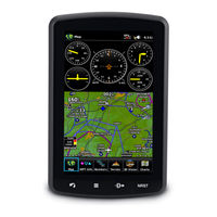
area portable touchscreen GPS
Brand:
Garmin
| Category:
GPS
| Size: 0.59 MB
Advertisement
Related Products
Garmin aera 500
Garmin aera 550
Garmin aera 510
Garmin aera 1900111700
Garmin aera 190-01117-02
Garmin aera 560
Garmin aera 795
Garmin AERA 660
Garmin Aera 760
Garmin Approach G5 North and Latin America
Garmin Categories
GPS
Watch
Car Navigation system
Avionics Display
Marine GPS System
More Garmin Manuals
Login
Sign In
OR
Sign in with Facebook
Sign in with Google
Upload manual
Upload from disk
Upload from URL