Sign In
Upload
Manuals
Brands
Brunton Manuals
GPS
Atlas MNS
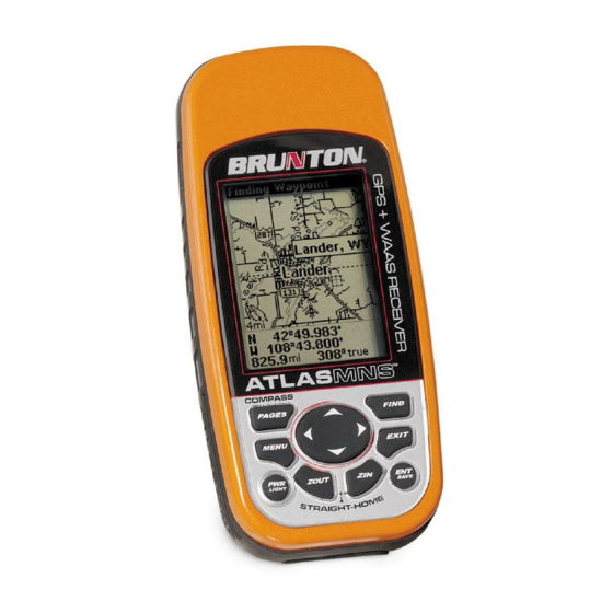
Brunton Atlas MNS Handheld GPS Manuals
Manuals and User Guides for Brunton Atlas MNS Handheld GPS. We have
1
Brunton Atlas MNS Handheld GPS manual available for free PDF download: Operation Instructions Manual
Brunton Atlas MNS Operation Instructions Manual (128 pages)
Handheld Mapping GPS Receiver
Brand:
Brunton
| Category:
GPS
| Size: 1 MB
Table of Contents
Operation Instructions
1
Table of Contents
3
Section 1: Read Me First
9
Capabilities and Specifications: Atlas-MNS
10
How Atlas Works
12
Introduction to GPS and WAAS
13
How to Use this Manual: Typographical Conventions
15
Arrow Keys
15
Keyboard
15
Menu Commands
15
Instructions = Menu Sequences
16
Section 2: Installation & Accessories
17
Power
17
Batteries
17
Battery Installation
18
Cigarette Lighter Power Adapter
18
NMEA Cable Connections
19
MMC or SD Memory Card Installation
20
To Remove an MMC
20
To Add an MMC or SDC
21
Infocards
22
External Antenna
22
R-A-M ® Bracket Mounting System
23
Other Accessories
24
Section 3: Easy Mode Operation
25
Keypad
25
Power/Lights on and off
26
Main Menu
26
Satellite Status Page
27
Navigation Page
28
Calibrate Compass
30
Compass Menu
32
Map Page
32
Atlas-MNS ™ Easy Mode Quick Reference
36
Find Your Current Position
37
Moving Around the Map: Zoom & Cursor Arrow Keys
37
Selecting any Map Item with the Cursor
38
Searching
38
Set Home Waypoint
40
Navigate to Cursor Position on Map
41
Navigate to a Point of Interest
42
Creating and Saving a Trail
42
Displaying a Saved Trail
43
Navigating or Backtracking a Trail
44
Visual Back Trailing
44
Navigate a Back Trail
44
Clearing or Erasing a Trail
46
Transfer Custom Maps and GPS Data Files
46
Custom Maps
46
GPS Data Files
47
Switch to Advanced Mode
49
Switch Back to Easy Mode from Advanced Mode
49
Section 4: Advanced Mode Operation
50
Keypad
50
Power/Lights on and off
51
Main Menu
51
Satellite Status Page
51
Status Menu
52
Position Page / SLEEP Mode
52
Position Menu
53
Naviagion Page
54
Compass Menu
56
Map Page
56
Map Menu
57
Moving Around the Map: Zoom & Cursor Arrow Keys
57
Find Distance from Current Position to Another Location
58
Find Distance from Point to Point
58
Find Your Current Position
58
Icons
59
Create Icon on Map
59
Create Icon at Current Position
59
Delete an Icon
60
Load GPS Data Files from an MMC
60
Navigate
61
Navigate Back Home
61
Navigate Back to Home Waypoint
61
Cancel Navigation
61
In Easy Mode
61
In Advanced Mode
61
Navigate a Route
61
Navigate to Cursor Position on Map
61
Navigate to an Icon
62
Navigate to Point of Interest (POI)
62
Navigate to a Waypoint
62
Navigate a Trail
62
Backtrack a Trail
63
Routes
63
Create and Save a Route
63
PC-Created Routes
64
Routes Created in Atlas
64
Delete a Route
65
Save GPS Data Files to an MMC
65
Searching
66
Switch to Easy Mode
67
Switch Back to Advanced Mode from Easy Mode
68
Trails
68
Create and Save a Trail
68
Clear a Trail
68
Delete a Trail
68
Edit a Trail Name
69
Transfer Custom Maps and GPS Data Files
69
Custom Maps
69
GPS Data Files
69
Utilities
70
Alarm Clock
70
Sun/Moon Rise & Set Calculator
70
Trip Calculator
70
Trip down Timer
70
Trip up Timer
70
Waypoints
70
Create a Waypoint
70
Create Waypoint on Map
70
Create Waypoint at Current Position
71
Create a Home Waypoint
71
Create a Waypoint by Average Position
71
Create a Waypoint by Projecting a Position
71
Select a Waypoint
72
Delete a Waypoint
72
Edit a Waypoint
72
Waypoint Name
72
Waypoint Symbol
72
Waypoint Position
72
Waypoint Altitude
72
Section 5: System & GPS Setup Options
73
Alarms
73
Auto Satellite Search
74
Check MMC Files and Storage Space
75
Com Port Configuration
75
Configure NMEA
76
Coordinate System Selection
76
Map Fix
78
Customize Page Displays
79
Customize Position Page
79
Customize Navigation Page
79
Customize Map Page
79
External Passive Antenna
80
GPS Simulator
80
Simulating Trail or Route Navigation
81
Map Auto Zoom
82
Map Data
82
Show Map Data
82
Popup Map Information
82
Draw Boundaries
83
Fill Land with Gray
83
Map Overlays (Range Rings; Lat/Long Grid)
83
Map Datum Selection
83
Map Detail Category Selection
84
Map Orientation
85
Navionics Charts
86
To Display a Navionics Chart
86
Port Information
87
To View Port Services Information
87
Tidal Current Information
88
To View Tidal Current Information
89
Tide Information
90
To View Tide Information
90
Pop-Up Help
91
Reset Options
92
In Advanced Mode
92
In Easy Mode
92
Screen Contrast and Brightness
92
Once in the Screen Menu
93
Set Language
94
Set Local Time
94
Once in the Time Settings Menu
95
Software Version Information
95
Sounds and Alarm Sound Styles
96
Once in the Sounds Menu
97
Track Smoothing
97
Trail Options
98
General Trail Options
98
Flash Trails on Screen Option
98
Update Trail Option
99
Update Trail Criteria (Auto, Time, Distance)
99
Trail Update Rate (Time, Distance)
100
Specific Trail Options
100
Delete Trail
100
New Trail
100
Trail Visible/Invisible and Other Trail Options
101
Units of Measure
101
Section 6: Searching
103
Find Addresses
103
Find any Item Selected by Map Cursor
105
Find Home Waypoint
106
Find Interstate Highway Exits
107
Find Map Places or Points of Interest (POI)
108
Find Streets or Intersections
110
Find Waypoints (Advanced Mode Only)
112
Section 7: Supplemental Material
115
Fcc Compliance
122
How to Obtain Service
126
Advertisement
Advertisement
Related Products
Brunton Atlas
Brunton ADC Wind
Brunton ADC Pro
Brunton ADC Summit
Brunton Multi-Navigator
Brunton Categories
Compass
Camping Equipment
Measuring Instruments
Binoculars
Solar panel
More Brunton Manuals
Login
Sign In
OR
Sign in with Facebook
Sign in with Google
Upload manual
Upload from disk
Upload from URL