Table of Contents
Advertisement
Advertisement
Table of Contents

Summary of Contents for Haiyang AQUA HGP-660
- Page 1 - 1 -...
-
Page 2: Table Of Contents
TABLE OF CONTENTS Important Notice AQUA Color LCD Charting System………………………………… 14 Welcome Introduction Specification Display Unite Interconnecting diagram Slots & SPEC of the connectors The Keyboard Page Select……………………………………………………………… 1. LAT/LON mode 2. Full Information 3. Large LAT/LON 4. Steering mode 5. - Page 3 3. Selecting WPT. 4. Editing WPT. Route ……………………………………………………………… 1. Instant Route 2. Creating Route 3. Selecting Route 4. Deleting Route 5. Reversing Route 6. Setting Point 7. Edit the existing route 8. Editing Route Track ……………………………………………………………… 1. Track On/Off 2. Changing Track Color 3.
- Page 4 GPS Setup 2/2 ……………………………………………………… 42 1. AIS Setup Setup 1/2 ……………………………………………………… 43 1. Distance/Speed unit 2. Present Position Size 3. Track Size 4. Track Display Interval 5. Time Interval 6. Distance Interval 7. Heading Line Length 8. True/Magnetic 9. Compass Modification 0.
- Page 5 Map Setting ............... 47 1. Vessel offset 2. Correction offset for LAT. 3. Correction offset for LOT. 4. Compute Correction 5. Depth unit 6. Fonts & Symbols 7. Mixing Levels 8. Perspective View 9. Dynamic Nav-Adis 0. Chart Boundaries Alarm ………………………………………………………………… 49 1.
- Page 6 Map Orientation ............1. True Motion 2. North up 3. Course up 4. Head up AIS System ..............Plotter Menu ............... 1. Track 2. Navigating 3. Mark 4. Object Information Cursor Menu ............... 1. WPT 2. Mark 3. Range/Bearing 4. Object Information Find .................
- Page 7 ………………………………………………………………………… 60 How GPS works Position Fixing Accuracy: HDOP The Installation of The GPS ANT. - 7 -...
- Page 8 - 8 - - 8 -...
- Page 9 - 9 -...
-
Page 10: Important Notice
Important Notice Keep this manual in a safe place where you can access it quickly. Manual This Manual must be passed to a new owner of the AQUA when it is Handling transferred. The Global Positioning System (GPS) consists of a total 24 GPS satellites that orbit the earth, enabling you to determine your position anywhere in the world, 24 hours a day, if you can receive satellite signals. - Page 11 Pictorials This manual uses the following symbols for easy understanding safety instructions. Always follow these instructions carefully. WARNING Always follow this safety instruction to prevent death or injury. Follow this safety instruction to avoid possible injury or damage to your property. CAUTION Symbol “△”...
- Page 12 Installation Cautions <For service Personnel> Follow installation instructions to avoid personal injury and system malfunction. Installation in Mount your AQUA on a rigid frame or base to prevent your unit from working loose. rigid location. Use correct Use the installation materials provided in the standard accessory Installation pack only.
- Page 13 Operation Notes <For operators> Observe the following operation notes, otherwise the system failure or deterioration can result. And periodical inspection and maintenance are required for keeping the system in an optimum condition. The waypoint and other registered data may become unreadable Backup important by unexpected failure.
-
Page 14: Aqua Color Lcd Charting System
AQUA Color LCD Charting System Welcome The AQUA Color LCD Charting System opens a new chapter of performance and integration in vessel navigation system display and management. Whether you are a Cruiser or Sport fisherman or both, AQUA gives you the information you need. CAUTION The AQUA is Color LCD Charting Systems employs the latest in proven technology to provide accurate navigation information. -
Page 15: Introduction
AQUA Color LCD Charting System Introduction The AQUA Color LCD Charting System is a premium multifunction command and control center. It combines in one unit, display of worldwide cartography, GPS navigation and Echo Sounder. AQUA front panel keyboard and its large screen with wide viewing area make placement easy. Although AQUA offers many advanced features, operation is simplified through the use of popup menus similar to those found on personal computers. - Page 16 AQUA Color LCD Charting System GETTING STARTED This getting Started section will help you become acquainted with the displays and the front panel keyboard functions of your AQUA Color LCD Charting System. This section is intended to demonstrate the main functions and basic operation of your AQUA System. More detailed procedures may be found in the Operation section.
-
Page 17: Specification
Antenna Unit: -25°C ~ 70°C 3. Performance Standard IMO Resolution MSC.112(73) 4. Back-up SD Card (Optional) 5. Optional HAIYANG Chart with SD Card CHARTPLOTTER SPECIFICATION 1. Display Method Mercado Projection 2. Display Mode True motion / North up / Course up / Head up 3. - Page 18 AQUA Color LCD Charting System 13. Output Data NMEA-0183 14. Input Data NMEA-0183 15. Alarm Arrival, Anchor, Off course, Interval timer GPS RECEIVER GENERAL SPECIFICATION 1. Receive Type L1 frequency(1575.42MHz), C/A code 2. Number of Channel 16 channels 3. Accuracy Position 2.5m CEP DGPS/SBAS 2.0m CEP 4.
-
Page 19: Display Unite
AQUA Color LCD Charting System Display Unit The heart of the AQUA Color LCD Charting System is the display unit. Within the display unit are the powerful central processor and integrated display system, built-in cartography. The bright 6.5 inch active matrix color LCD, is easily viewed over a wide area on the bridge or nav center. Knobs Slots Mounting Bracket... -
Page 20: Interconnecting Diagram
AQUA Color LCD Charting System Interconnecting diagram SPEC of the connectors Speaker (*see 16 page) Connector PWR&I/O Antenna Connector - 20 -... - Page 21 AQUA Color LCD Charting System Slots C-CARD slot C-MAP NT+ and C-MAP MAX NT are available Mini USB port Upgrade of new S/W and charts is available through port. particular upgrade S/W, “DNW” is necessary for upgrade. SD card slot Upgrade, back-up of user data(WPT, Mark, Track, etc) and loading data are available with a SD card of which the...
-
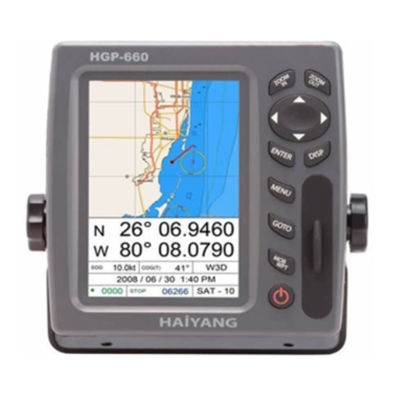
Page 22: The Keyboard
The Keyboard Cursor pad Select display mode & Clear Power & Brightness [ZOOM-IN] CHANGE THE CHART OF SCALE BIGGER IN PLOTTER [ZOOM-OUT] Change the chart of scale smaller in plotter [MENU] Menu opens menu to select options Cursor display: Place the cursor and press “GOTO’ to set WPT [GOTO] No cursor/Pointed WPT: Save WPT and set free the pointed WPT No cursor/No pointed WPT: List for WPT, route... - Page 23 - 23 -...
- Page 24 Page Select Pressing the key, [DISP], you will see the following pages. Move the red box with the arrow key and press the key, "ENTER". The chosen page will be active. Please, kindly note that the FF page will be available when the display is connected with a black box FF. - 24 -...
-
Page 25: Page Select
Page Select 1. Simply LAT/LOT mode Simple LAT/LON mode supplies LAT/LON, speed, bearing only. The large chart supports on display. Bearing Distance WPT’s Name WPT’s coordinates Time to Go Ship’s coordinates -Red: Receiving unavailable -Black: Receiving available -Skyblue: DGPS or SBAS (WASS/EGNOS) available *GPS Receiver Status INDICATION... -
Page 26: Full Information
Page Select 2. Full Information mode Full information mode supplied all details for navigation. (LAT/LON, Speed, Bearing, GPS status, Date & Time, Symbol of marks and numbers, Number of tracks, Number of receiving Satellites) Ship’s coordinates Course Over Ground GPS Receiving status Speed Over Ground Date and Time Receiving Satellites... -
Page 27: Large Lat/Lon
Page Select 3. Large LAT/LON mode Large LAT/LON shows receiver status, position in latitude and longitude, course over ground, speed over ground, date and time. Time and Date Receiving status Ship’s coorinates Course Speed Over Over Ground Ground - 27 -... -
Page 28: Steering Mode
Page Select 4. Steering mode The steering display provides steering information such as ship’s speed, course, range, bearing, TTG. Course Over Ground Bearing Compass Distance graphic Speed indicator Over Groun WPT’s Name Time to Go Cross Time Error -L: left -R: right - 28 -... -
Page 29: Highway Mode
Page Select 5. Highway Mode The highway Mode provides a 3D view of own ship’s progress toward destination (waypoint). Bearing WPT’s Name Course Over Ground Distance Ship Heading Speed XTE Radius Over Cross-Track Error Ground - 29 -... -
Page 30: Full Highway
Page Select 6. Full Highway mode The highway mode provides a 3D view of own ship’s progress toward destination (waypoint). WPT’s Name Ship Heading Course Over Speed Speed Over Ground Bearing Distance Time To Go Cross To Error -L: left -R: right - 30 -... -
Page 31: Full Gps Data
Page Select 6. Full GPS Data Full GPS data mode supplies all information of GPS data. Course Receiving Over status Ground Satellite status Satellite list -Black: no signal SAT. 1. Order -Blue: not used SAT. 2. Number of SAT. -Green: used SAT. 3. -
Page 32: Edit
Operations Edit Edit numbers, symbols, colors of Mark, WPT, Route. 1. Editing Character [←],[→]: move the position [↑],[↓]: move the bar [ZOOM IN][ZOOM OUT]: input letters [ENTER]: choice and input 2. Editing Number [←],[→]: move the position [↑],[↓]: change the number [ENTER]: choice and input - 32 -... - Page 33 Operations Edit 3. Editing Symbol [↑],[↓]: move the bar [ENTER]: choice and input 4. Editing Color [↑],[↓]: move the bar [ENTER]: choice and input - 33 -...
-
Page 34: Mob
Operations ※MOB/Mark key - without the cursor : MOB or inputting a mark at the present position MOB : ▶ [MOB/WPT] -> [ENTER] Mark : ▶ [MOB/WPT] -> all keys except [ENTER] - with cursor : only mark is available at the cursor ▶... -
Page 35: Mark
Operations MARK Mark means that a user indicates an important position or a point such as a fish heaven or a danger area for sailing. This is one of the most important functions in the plotter. 1. Creating Mark ▶ move the position to where you want and press [MARK/MOB]. - addition in the edit of mark: (※PLS, refer the edit list) 2. -
Page 36: Creating Destination Point
Operations Waypoint(WPT) Waypoints may be entered and stored in the waypoint library by any of two different methods. You may use the cursor to select locations from a chart, or store vessel present position as a waypoint 1. Creating destination point You can place the destination point and immediately start navigating to it. -
Page 37: Route
Operations Route 1. Instant Route Use waypoints to create a instant route for your sailing. The capacity of waypoints are 20 point. Every time you put waypoints on the screen, the temporary route is drawn on the screen. ▶ [CURSOR PAD]->[GOTO]->[CURSOR PAD]->[GOTO]->..->[ENTER] - Saving Instant Route: when saving the present instant route ▶... -
Page 38: Track
Operations Track The Track function provides a record of the path over which your vessel has traveled. A track is a series of lines connecting points of vessel present position which are plotted at wither time or distance intervals. Tracks are recorded and stored one at a time. AQUA supports five different tracks, each has up to ten thousand (10,000) points of track history. -
Page 39: Display On/Off
Operations Display ON/OFF The menu selects icons or symbols and lines displayed ON/OFF. ▶ [MENU]->[2.Display ON/OFF] ->[Enter]->[←][→] (* If you want to go to next page of the menu, press [MENU]) (* In C-MAP, it could be different from HY-chart.) - 39 -... -
Page 40: Datum
Operations GPS Setup It is available to control and confirm information in GPS receiver. (* For next page, press [MENU]) ▶ [MENU]->[3.GPS Setup] ->[Enter] GPS Setup 1/2 1. Datum: It shows GPS Datum. WGS-84, which is the worldwide standard is only available. (☞... -
Page 41: Average Sog
Operations GPS Setup 7-2. Average SOG(*): It sets time by second for average speed. It is a special function for a fishing boat. (※ Although you set a time to the menu, it is unavailable if the menu, No. 5(Smoothing ser is off.) (☞... - Page 42 Operations GPS Setup It is available to control and confirm information in GPS receiver. (* For next page, press [MENU]) GPS Setup 2/2 1. AIS Setup It sets AIS on/off, AIS Scale, CPA Alarm, CPA Limit, TCPA Alarm, TCPA Limit. Closest Point of Approach is the closest distance that will be achieved between your vessel and the tracked target, based on your vessel’s speed and direction and the target’s speed and direction.
- Page 43 - 43 -...
- Page 44 Operations Setup It is available to set the menu or units for user’s visual confidence. (* For next page, press [MENU]) ▶ [MENU]->[4.Setup] ->[Enter] Setup 1/2 1. Distance/Speed Unit: Select desired unit of measure for distance and speed. Choose from: nautical mile/knots (nm/kt), kilometer/kilometers per hour(km/kmh), yard/knot(yd/kt).
- Page 45 Operations Setup It is available to set the menu or units for user’s visual confidence. (* For previous page, press [MENU]) ▶ [MENU]->[4.Setup 1/2] ->[Enter]->[MENU] Setup 2/2 1. Displaying Time Setup: Provides for local time offset (-12:00 to +13 hours in 1/2 hour steps) from UTC. 2.
- Page 46 Operations Setup 8. Save Track Current Track save to Track data. 9. Load Track Saved Track load to display 0. Time Format Sets you preferred time between 12 hour and 24 hour. The default setting is 12 hour. - 46 -...
- Page 47 Operations Maintenance It is necessary to check the system or the version for maintenance and demonstrate AQUA with the simulators ▶ [MENU]->[5.Maintance] ->[Enter] 1. System Information It contains ID and the program version, and it has important information for maintenance and upgrade.
- Page 48 Operations Map Setting It is available to set the menu of the chart options. ▶ [MENU]->[6.Map Setting]->[Enter] 1. Vessel Offset It is possible to be set up positions of 0, 1/3, and 2/3 by the standard of the center of chart screen.
- Page 49 Operations Map Setting It is available to set the menu of the chart options. ▶ [MENU]->[6.Map Setting]->[Enter] 8. Perspective View Chart data may be projected in perspective mode during navigation. This function allows setting the panoramic View of the chart. As the upper side of the map is more compressed than the lower side, a wider map area is visible.
- Page 50 Operations Alarm Special notices are necessary on sailing. AQUA has four kinds of alarm, arrival, out of the course, anchor and time. ▶ [MENU]->[7.Alarm] 1. Arrival Alarm: When you approach into the waypoint range, it gives you a notice with alarm. 2.
- Page 51 Operations User Data Edit It is possible to set the menu of user data. (Track, Mark, WPT, Route) ▶ [MENU]->[8. User Data Edit]->[Enter] 1. Track On/Off It is available to set start and stop the track. 2. Track Color It is available to set the track color. Use curser to change the color. 3.
-
Page 52: Map Orientation
Operations Map Orientation There are four display modes for Main Screen that involve the Plotter or Radar screen. Both Plotter and Radar mode change together regardless ok which one is active when a mode change is made. The display modes are: Normal mode, North up, Course up, Head up ▶... -
Page 53: Ais System
Operations AIS System It is a vessel equipped with AIS. Information about the targets is being received by AIS Receiver and displayed on the screen. (☞ Refer to AIS Setup for GPS Setup 2/2 of AIS setup.) Name Name of ship, 20 characters. MMSI Maritime Mobile Service Identity. -
Page 54: Plotter Menu
Operations Plotter Menu Press [ENTER] key without cursor, it shows Plotter Menu. 1. Track It is possible to setup start and stop of Track. 2. Navigating It is possible to setup start and stop of Navigating. 3. Mark Mark is input on the Vessel Position. 4. -
Page 55: Find
Operations Find The charplotter allows finding Nearest Services, Port By name, Port by distance, Tide Stations, Wrecks, Obstructions. 1. Port Services To locate and display the nearest available facilities of a particular type. ▶ [ENTER]->[4.Object Information]->[ENTER]->[Zoom in]->PORT SERVICES->[ENTER] The icons of the available services are shown. Use the cursor key to select any facility and press [ENTER]. -
Page 56: Obstructions
Operations Find The charplotter allows finding Nearest Services, Port By name, Port by distance, Tide Stations, Wrecks, Obstructions. 6. Obstructions Searches for nearest Obstructions. ▶ [ENTER]->[4.Object Information]->[ENTER]->[Zoom in]->OBSTRUCTIONS->[ENTER] Use the cursor key to select the port. Press [ENTER] to locate the selected Obstrutions. - 56 -... - Page 57 - 57 -...
-
Page 58: Installation
Installation AQUA brings expandable display technology to your bridge or navigation station. A careful installation will assure maximum benefit from AQUA integrated features. Display Unit Location Select a location for your AQUA display unit that provides easy viewing from all likely operator’s positions. -
Page 59: Power Connection
Installation Drill a 1/4 in. diameter hole at each marked location. Mount the AQUA display bracket using bolts through the mounting surface. Place large flat washers on the opposite side of the mounting surface from the bracket and then install lock washers and nuts. Tighten securely. Install the display unit into the mounting bracket. -
Page 60: Reference
Reference - Care and Cleaning Your AQUA is made to withstand marine elements but a little care ensures a trouble free life. Accumulations of salt and sand, if not removed, will eventually mar the finish. No solvents or harsh cleaners should be used. The display unit may be wiped down with a damp cloth while avoiding the display window. - Page 61 For centuries, sailors have een searching for a reliable and precise method of travelling the worl d’s waterways. From celestial navigating to the modern navigation techniques as Loran, Decca navigator, Omega or Transit Satnav, each system has had its problems with weather, range and reliability.
- Page 62 The position calculation procedure is indicated in the following three steps: 1. GPS satellites continuously transmit their own precise orbital data and the GPS receiver comp utes their locations by receiving this data. 2. In this receiving process, the GPS receiver measures very accurate distances to the satellites, using the "Spread Spectrum Modulation"...
- Page 63 The installation of the GPS ANT. The GPS ANT must be installed at the highest area of the boat and the easiest place to catch the signal from the satellites. If there are obstacles around the GPS ANT, it isn't able to catch all signals.
-
Page 64: Power Diagram
- 64 -... - Page 65 - 65 -...
- Page 66 - 66 -...
- Page 67 Web-site: http://www.haiyang.co.kr Guarantee for One Year Haiyang Electronic Equipment Co., LTD warrants the produced Chartplotter and Fish Finder, AQUA for One (1) year for guarantee as bellows. 1.Main Unit: One (1) year guarantee after a user purchases the product within one (1) year 2.
Need help?
Do you have a question about the AQUA HGP-660 and is the answer not in the manual?
Questions and answers