
Summary of Contents for Cammenga PRECISION LENSATIC
- Page 1 THE OFFICIAL U.S. MILITARY PRECISION LENSATIC COMPASS INSTRUCTIONAL BOOKLET 100 Aniline Avenue, Suite 258 Holland, Michigan 49424 Phone (616) 392-7999 Fax (616) 392-9432 www.cammenga.com...
-
Page 2: Table Of Contents
INSTRUCTIONAL BOOKLET SECTION PAGE INTRODUCTION PARTS OF THE LENSATIC COMPASS DETERMINE DIRECTION (SIGHTING AN AZIMUTH) TO SET A COURSE (3 METHODS TO FOLLOW A BEARING) PROCEEDING ALONG AN AZIMUTH DECLINATION ADJUSTMENT (3 METHODS TO ORIENT A MAP) LOCATING POSITION USING INTERSECTION TOTAL DARKNESS USAGE DEFINITIONS GENERAL INFORMATION... -
Page 3: Introduction
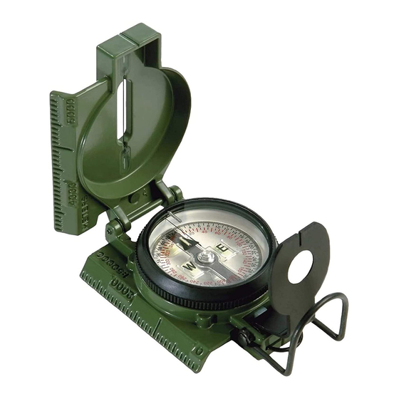
A. INTRODUCTION The instructions in this booklet are for the CAMMENGA LENSATIC COMPASS currently being distributed by the U.S. Army and Troop Command. This compass is known throughout the world for its precision, reliability, versatility, ruggedness and much more. It has helped to save lives in times of war and provided many with recreational and commercial usefulness in times of peace. - Page 4 Luminous Bezel Indicator: Used to mark an azimuth during day or night. 2. Dial: Displays direction in reference to Magnetic North. The Dial is divided into two scales; a. Outer - (black printing) graduated in mils. • 6400 mils to a circle •...
- Page 5 6. Case Cover: Closes to protect the compass and reduce carrying size. When opened wide (fig. 1), it can be used as a straight edge or ruler. When perpendicular (fig. 2), the Sight Wire (4) is used to set a course of movement. 7.
-
Page 6: Determine Direction
C. DETERMINE DIRECTION (SIGHTING AN AZIMUTH) 1. Open the lensatic compass as shown in figure 2. a. Case cover should be perpendicular (90°) to the case. b. Tilt the Lens Bracket about 30° from perpendicular. Be sure the Dial floats freely. 2. -
Page 7: To Set A Course
D. TO SET A COURSE (FOLLOW AN AZIMUTH) 1st Method 1. With the lensatic compass opened wide (fig. 1) and held level, turn it horizontally until the azimuth is directly under the black Index Line. Example: you want to follow an azimuth of 120 degrees. -
Page 8: Proceeding Along An Azimuth
3rd Method 1. Turn the fully opened compass and rotate the Bezel to align the lights in the case cover with the Luminous Bezel Indicator. 2. Rotate the Bezel counterclockwise to the azimuth desired. Each distinct click of the Bezel represents 3 degrees. Example: you want to follow a course of 120 degrees. -
Page 9: Declination Adjustment
a. Head for the point on the travel path that is beside the alternative steering mark. At this position sight a back azimuth to the old steering mark. A back azimuth is 180 degrees away from a traveled azimuth. If traveled azimuth is less than 180 degrees, add 180 degrees. - Page 10 2nd Method - With no declination diagram shown on the map. 1. Find the magnetic declination value in the map margin. This will state the difference between True North and Magnetic North to be so many degrees East or West. Example: Magnetic declination 11 degrees West means The North arrow of the lensatic compass will point 11 degrees West of True North.
-
Page 11: Locating Position Using Intersection
G. LOCATING POSITION USING INTERSECTION 1. Orient the map to the terrain. 2. Sight an azimuth to any visible terrain feature that appears on the map. 3. Place the fully opened lensatic compass on the map with the scale edge running through the terrain feature and with the compass reading the same as the azimuth sighted. -
Page 12: Definitions
I. DEFINITIONS 1. Azimuth - A horizontal angle in respect to North (360 degrees, 6400 mils). The number directly under the black Index Line reads an azimuth on the Dial in either degrees or mils. Example: azimuth of 90 degrees or 1600 mils (read 16) is due East. -
Page 13: General Information
3. Magnetic Declination - The horizontal angle (difference in degrees) between Magnetic North, Grid North, and True North. Magnetic declination varies from area to area and from time to time: Generally about 1’ (one minute) per year (There are 60 minutes to one degree). The declination will be shown in the marginal information on your map. - Page 14 Coordinates are determined using the North/South and East/West lines on a map (grid lines). Positions are determined on a map by intersecting coordinates. The lower left is the origin and coordinates are read to the right and then up. (see fig. 5) The position of “X”...
- Page 15 The CAMMENGA LENSATIC COMPASS uses induction damping to slow the rotation of the magnet. Induction damping allows the Dial to seek Magnetic North and come to a complete rest in much less time than a unit without induction damping. It is a velocity dependent force; that is, as the speed of the oscillation of the Dial comes to rest, the damping force is zero.
-
Page 16: Appendix
APPENDIX SECTION PAGE A. Introduction B. Parts of the Lensatic Compass Figure 1 1. Luminous Bezel Indicator 2. Dial 3. Scale Edge 4. Sight Wire 5. Bezel 6. Case Cover 7. Case 8. Thumb Loop 9. Lanyard 10. Lens Bracket 11.
Need help?
Do you have a question about the PRECISION LENSATIC and is the answer not in the manual?
Questions and answers