Table of Contents
Advertisement
Quick Links
Download this manual
See also:
User Manual
Advertisement
Table of Contents

Related Manuals for Voyager Trail Tech

Summary of Contents for Voyager Trail Tech
- Page 1 MOTO-GPS...
- Page 2 Quick-Start » Screens Main Tab Main Tab 2 Use the joystick Pan/Zoom Map Tab to navigate Mode up and down between Engine Engine screens. Temperature Temperature Review Altitude Altitude Tab Review User Tab User Tab 2...
-
Page 3: Quick Start
BACK Backs out of ENTER any screen or Confi rm menu. Press changes or 2-3 times to switch to next return to main screen. tab. Trail Tech Voyager... - Page 4 Introduction Introduction Trail Tech brings functionality and life to your If you call to request service for your Voyager motor vehicle with high quality and innovation. digital gauge, you need the date of purchase, To ensure long and trouble-free operation, this ...
- Page 5 Precautions Precautions WARNING: • Do not plug Voyager directly into a wall outlet • Check gap between wheel sensor and magnet except with a Trail Tech wall charger. periodically. • Read all instructions before using Voyager.
- Page 6 Voyager handheld without any sensors connected. However, physically bolting Voyager 4. How do I mount Voyager to my machine? to your vehicle provides many advantages over Vehicles with handlebars can use the included ...
- Page 7 sensor for several reasons: and hour meter are critical features. To maintain A . When using a wheel sensor, Voyager knows this accuracy, kits are provided with a wheel to stop logging when the vehicle stops moving. ...
- Page 8 9. My vehicle does not have a battery or a The fi rst sleep mode shows the clock on headlight. Can I run Voyager? Yes. Voyager the screen. Some features are turned off to ...
-
Page 9: Specifications
11 hours Critical Environment Amber/Red LED A lerts Battery Life (100% backlight) 6 hours Max Waypoints 300 waypoints Battery Charge Time 3-8 hours Max Track Points 72,500 points Max Route Points 72,500 points Max Tracks/Routes 300 each Trail Tech Voyager... -
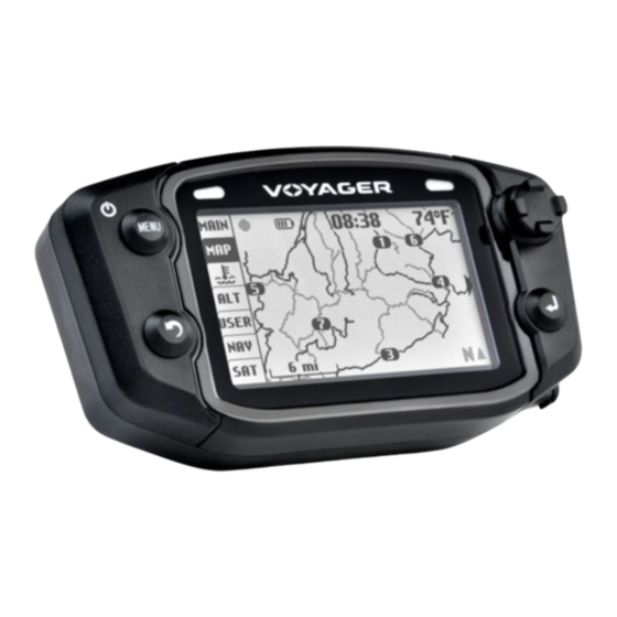
Page 10: Physical Features
Internal GPS A ntenna Yellow LED Red LED Joystick (UP, MENU Button LEFT, RIGHT, DOWN) BACK Button ENTER Button MicroSD Card Precision Wheel Sensor Engine Temperature Sensor Ignition Sensor Vehicle Power Ambient Temperature Sensor Trail Tech Voyager ... -
Page 11: Internal Battery
Antenna Holes Connector External Antenna: Voyager can run from the An external GPS antenna accessory will get better reception if internal battery, but it is the mounting location interferes with the reception of the internal ... - Page 12 Physical Features » Bar Mount Bar Mounting: The included bar clamps fi t 7/8” through 1-1/8” handlebars. Place the nuts and bolts as shown. Adjust angle as required. Trail Tech Voyager ...
- Page 13 Use the included M4 bolts to mount to any fl at surface. If other than provided screws are used, make sure they are not too long for mounting holes or they will damage internal components of Voyager.
- Page 14 MicroSD Card Tracks saved on your computer can be placed on the MicroSD memory card, then imported onto Voyager for viewing and route following. This is a great way to share tracks with your friends, or for pre-planning your own trips.
-
Page 15: Vehicle Power
12 volt battery. A lternately tap into the electrical procedure. system (preferably not interrupted by the key Cylinder Head Sensor: switch.) Voyager is For air-cooled machines. polarity independent. Spark Plug CHT Temperature ... -
Page 16: Sensor Notes
ALWAYS ON on. If the sensors aren’t installed, you need to enable logging regardless of connected sensors. Voyager can stay on for twice as long if you Voyager Voyager Set > GPS Settings > Log Option: ALWAYS disable the backlight. - Page 17 2. A speed sensor, on the non-spinning part of the wheel. The magnet spins around tripping the sensor switch ATV Speed each time--giving Voyager speed, distance and time Sensor data to compare with the GPS data.
- Page 18 The wheel sensor should be cable-tied to the brake line, then attached to the brake caliper. Magnet Passing Under Sensor Voyager can tell precisely how far and fast it’s traveled by how many times the magnet passes the sensor.
- Page 19 Measure the distance between the marks on the ground in millimeters (multiply inches by 25.4 to convert to mm). Use this number for your wheel size. For accuracy, the rider’s weight should be on the bike when making the measurement. Trail Tech Voyager...
- Page 20 (actual miles) x (current wheel size) (new wheel size) (current miles) 5 x 2110 X = 4.95 10550 X = 4.95 X = 2131 5. Enter the number you calculate from the above formula into Voyager. Trail Tech Voyager ...
-
Page 21: User Interface
User Interface » Main Tab User Interface Voyager has 7 tabbed screens: Main, Map, Main Tab Screen 2: Engine Temperature, A ltitude, User Defi nable, There are two screens in the Main Tab, hinted by ... - Page 22 upper right Waypoints are also shown on the map. If you corner of the have uploaded routes to Voyager, they will be screen.) Map Pan Mode displayed in gray so that you can follow along.
- Page 23 User Interface » Engine Temperature & A ltitude Tabs Engine Temperature Tab: Altitude Tab: Voyager displays a graph of the engine The A ltitude Tab displays a graph similar to temperature’s history for the current trip in the ...
-
Page 24: Data Blocks
Display 1-6 data blocks. if you turn • Bearing • A vg GPS Speed (2) off some blocks, Voyager will center • Compass Direction the remaining blocks on the screen for • Input Voltage •... - Page 25 Set a destination waypoint at base camp before Latitude / Longitude: leaving, and the navigation compass always Press RIGHT from the satellite screen to view points back in case you get lost.. your current latitude and longitude positions. Trail Tech Voyager...
-
Page 26: Quick Menu
Toggle logging OFF/ON. Even if set to ON, frequently used commands, like toggling GPS logging will still pause if Voyager is not moving, logging. The ride menu controls features related does not have a GPS fi x, or if the LOG OPTION ... -
Page 27: Select Destination
Reset Trip Distance(1) is visible both on the Writes all tracks and waypoints to a fi le on the Main screen and User screen. Voyager has a MicroSD card. By default, it does not export ... - Page 28 Routes can be erased, renamed, or individually Difference between Tracks and Routes: toggled on/off. A route appears grey on Voyager. It is intended to show where to ride (i.e. un-ridden trails and roads.) A track appears black on Voyager. It shows the ...
- Page 29 Menu » Ride Menu Waypoints: If you select a destination waypoint, Voyager Waypoint will know that you wish to navigate towards display can it. On the Navigation tab the distance to the be toggled, ...
- Page 30 or reset the Trip DST/stopwatch counters. Resetting ride memory erases all tracks, routes, and waypoints currently in internal memory. Note that Voyager is unable to erase data from the MicroSD Ride Menu > Import/Export card;;...
- Page 31 4. The MicroSD card can also be fi lled up, depending what size of card you are using. Voyager is unable to erase data from the MicroSD card;; if you need to free up space, do ...
-
Page 32: Settings Menu
User Menu » Set Menu Settings Menu: Unit > Speed/Distance Units: The settings menu contains the options that Choose miles or kilometers. control the behavior of Voyager. Unit > Altitude Units: Choose feet or meters. Unit > Temperature Units: Choose Fahrenheit or Celsius. -
Page 33: Power Settings
“Always” mode is meant for use only (since the last button press or wheel movement) when Voyager is plugged into the wall using the when connected to the external vehicle battery. AC adapter (if used on a vehicle, the vehicle ... -
Page 34: Gps Settings
it is moving. Over time this will cause inaccuracy due to GPS signal wander. ART will not increment if Voyager falls into sleep GPS > Speed/DST: mode. By default, this will not happen because ... - Page 35 Fast, normal or slow. Fast creates more detailed fi les, while slow creates smaller fi le sizes (but If set to “always,” then Voyager will use GPS lower fi delity data.) movement to determine when to stop logging.
-
Page 36: User Settings
Set how long until the left tabs disappear. Voyager tracks and is able to User > Signal Bars: display. If turned on, satellite signal strength bars will appear on the main tab screen. Trail Tech Voyager ... - Page 37 to switch between screens 1 and 2. of the screen. A uto-center does not function in Press the enter button for pan/zoom mode to pan/zoom mode (see page 22.) change that screen’s zoom setting. Trail Tech Voyager...
-
Page 38: Utility Menu
or fl ash when the Utility > Software Update: temperature Upgrades Voyager software. Visit reaches set www.trailtech.net for the latest releases. A fter points. downloading from Trail Tech, copy the fi le to the ... - Page 39 After you have prepared your tracks, you will copy them to a MicroSD card, then import them to Voyager. Because Voyager has memory limits, the GPX editor is also useful to reduce the size of tracks and merge tracks before importing.
- Page 40 The roads are tracks, and will be imported Google Earth tab. If there are trails in your area, in Voyager as bold lines, so you can tell the you will see them with small trail icons. Click the ...
- Page 41 On Selected Selected Hand Tool, Pans Pointer Tool, Select Tracks Tabs switch between line-art preview and Google Maps/Satellite/Earth view. Google Maps Tab - Earth view. Hold down the center mouse button to modify perspective. Trail Tech Voyager...
- Page 42 of the data points (so it loads faster in map for each data point (many data points make Voyager.) Select the track with the select tool, up a track segment.) then press the Filter button in the toolbar. ...
- Page 43 5. Click the Export button. The fi le will export in .OSM format which needs to be converted to .GPX for Voyager. Open the fi le in RideLeader, then save as .GPX. Consider deleting excess waypoints and fi ltering down track data ...
-
Page 44: Gps Babel
“GPSBabel converts waypoints, tracks, and fi les, then click apply. routes between popular GPS receivers and mapping programs.” Before uploading the exported fi le to Voyager, ~ www.GPSbabel.org open it in the RideLeader to delete excess ... -
Page 45: Google Earth
Use your mouse to spin the planet, or shift+mouse to change the 3D view angle. You can view tracks exported from Voyager, or downloaded from OHVtrails.net or Openstreetmaps.com. You can also draw tracks that can ... - Page 46 Google Earth can import GPX fi les directly from button in the toolbar. A dialog box Voyager. Select Export on Voyager to save the appears (ignore it for now.) Using your ...
- Page 47 Download your adventure at www.OHVtrails.net. Download trails and load them directly into Voyager. Entire trail systems are at your fi ngertips. Hiking trails not allowed;; all included trails are either motorcycle, A TV, or ...
- Page 48 Trail Tech, Inc. are intended to be imported from internet data Thank you for using Voyager Moto-GPS. If you or previous rides and followed along. While have further questions, do not hesitate to call ...
- Page 49 You may also have other rights which vary from state to state. *Because some states do not allow the exclusion of incidental or consequential damages, this exclusion may not apply to you. MADE IN AMERICA Trail Tech and Voyager are trademarks of Trail Tech, Inc. www.trailtech.net 360-687-4530...
Need help?
Do you have a question about the Trail Tech and is the answer not in the manual?
Questions and answers