Table of Contents
Advertisement
Advertisement
Table of Contents

Subscribe to Our Youtube Channel
Related Manuals for Midland ALAN MAP 600

Summary of Contents for Midland ALAN MAP 600
- Page 1 Advanced cartographic navigator ALAN MAP 600 ® User´s Manual...
-
Page 2: Table Of Contents
ALAN MAP 600 Bedienungsanleitung Important Warnings ....13 7.1.11 Changing map references (Datum) Symbols used..............3 7.1.12 Set AR ..............13 Warnings ..............3 ..............14 7.1.13 Time Introduction Main Menu..............14 Your MAP 600 .............4 Description of the main pages Description of MAP 600 Selecting the main pages ........... - Page 3 ALAN MAP 600 user’s manual Deleting all Waypoints..........25 ..39 15.1.2 Memory Effect on rechargeable batteries Appendix B – Tabelle der voreingestellten Kartensysteme 41 Narrowing waypoint list..........26 ROUTES 10.1 Normal Routes............27 ..............27 10.1.1 Creating ........28 10.1.2 Activating for Navigation ......28 10.1.3...
-
Page 4: Important Warnings
ALAN MAP 600 user’s manual Warnings Important Warnings Warning! Symbols used Pay close attention to all of the warnings below. Failing to observe these warnings may result in serious problems and/or damage For ease and convenience in reading this manual, symbols are and/or personal injury. -
Page 5: Introduction
ALAN MAP 600 user’s manual Introduction Principal features and abilities of your MAP 600: Your MAP 600 • Reception and acquisition of up to 12 satellites Congratulations on your purchase! The MAP 600 is a GPS- • Menu selectable in 6 different languages receiver with high precision map display, electronically GPS- •... -
Page 6: Description Of Map 600
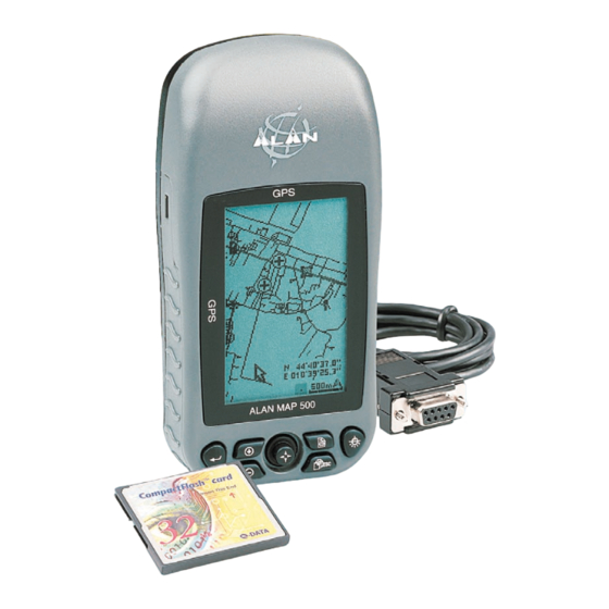
ALAN MAP 600 user’s manual Description of MAP 600 Buttons and controls 3.1.1 Front Panel [1] Integrated GPS-Antenna - for signal reception from GPS satellites. For optimal reception, the antenna should be pointed towards the sky at an angle of approx. 45 degrees. -
Page 7: Back Panel And Connections
ALAN MAP 600 user’s manual 3.1.2 Back Panel and Connections [9] Threaded junctures – for mounting on the bracket [10] Data socket (on the bottom of the receiver, under the protective cap) – for connecting to a PC via the DL 500 cable downloading of maps and various data, using a standard NMEA. -
Page 8: Preparation Unpacking
ALAN MAP 600 user’s manual Preparation 1 Compact Flash Memory card (CF-Card) Unpacking For memorizing digital maps, you can use CF cards of various When opening the box containing your receiver, ensure that the capacities: 16, 32, 64, 96, 128, 256 and 512 MB too. -
Page 9: Installation Of A Cf Memory Card And Batteries
ALAN MAP 600 user’s manual Installation of a CF memory card and batteries 4 Active external antenna The MAP 600 has a slot for Compact Flash memory cards (CF maps) with a capacity up to 512 MT for reading in detailed map The active antenna improves satellite reception for mobile use data. -
Page 10: The First Time You Use Your Map 600
ALAN MAP 600 user’s manual The first time you use your MAP 600 Initialisation of GPS receiver (first receiving) Before you use your navigation help for the first time, the MAP600 Turning on/off must determine his own position like all other GPS receivers 1. -
Page 11: Display Settings Rotating The Main
ALAN MAP 600 user’s manual Display settings Adjusting display contrast You can adjust the display contrast to optimize visibility in various Rotating the main pages lighting conditions. You can rotate viewing of the display in order to better use the 1. -
Page 12: Navigating The Command Menus
ALAN MAP 600 user’s manual Navigating the command menus Menu Settings Each page displays a series of options and settings, accessed This menu allows the user to personalize their receiver according through the command menu. to their needs and for optimum function of the device. This can The procedure for navigating the menus is as follows: be called up from any main page, as described above. -
Page 13: Backlight
ALAN MAP 600 user’s manual 4. Move the Joystick up/down to select the desired option NMEA 0183 compatible data interface device (e.g., transceiver, mapping instrument, etc). The available settings are: and press 5. If necessary, repeat steps 3 and 4 to change settings as (interface excluded) –... -
Page 14: Language
ALAN MAP 600 user’s manual 7.1.6 Language if it is necessary to change the coordinate format. Move the cursor left/ right to select the window Format. Use the With this feature, you set the language of the GPS menus. Italian,... -
Page 15: Time
ALAN MAP 600 user’s manual 7.1.13 Time Satellite – option to open the satellite page The GPS constellation allows to read data and time with extreme precision. Time is based on the Stop Navi/navigation – allows the changing of the Navigation... -
Page 16: Description Of The Main Pages
ALAN MAP 600 user’s manual Description of the main pages The centre of the internal circles indicates the perfectly vertical position. The numbers which appear are the identification Selecting the main pages numbers of the satellites received. The dark numbers represent... -
Page 17: Menu Of The Satellite Page
ALAN MAP 600 user’s manual 8.2.1 Menu of the satellite page Map page This page shows your position and direction of movement, shown Press the button to access the following options: by the symbol inside the GPS’ memorized map. In this map, you can create geographical references (waypoints) or routes a. -
Page 18: Menu Of The Map Page - Gerneral
ALAN MAP 600 user’s manual 50m – 100m - 200m (0.2miles) - 500m (0.5miles) – 1Km (1mile) – railway stations, hotels, restaurants, etc. These symbols can be 2Km (2miles) – 5Km (5miles) – 25Km (25miles) 100Km (100miles). made to appear/disappear individually on the map. -
Page 19: Search By City
ALAN MAP 600 user’s manual 8.3.2 Search by City 3.2 The Wild Card is recommended in areas, where all names starts similar (e.g. Plaza). Move the Cursor (left/right) to reach the Search by City is the search for reference points (e.g. town,... -
Page 20: Map Info
ALAN MAP 600 user’s manual 8.3.6 Navigating Route 4. Press the button. This will activate a menu which will allow you to select the search ray from your position (up to 5 Km or In the menu Navigating Route the settings and functions for 5 miles). -
Page 21: Map Scale
ALAN MAP 600 user’s manual k. Save, to save the Auto-Route. (Maximal 20 Auto-Routes d. Select Show fly Name with Name on or off, to show or could be stored) hide all dynamical Information which appears on the If a Auto-Route is created, in the Display the Name of the Auto- Screen when the Pointer is close the object. -
Page 22: Menu: Auto-Routing-Function
ALAN MAP 600 user’s manual - Hide All/Show All items To create a Auto-Route, you have to define Start- and Endpoint, - Hide Points/Show Points by pressing again 2 Seconds on the button and select - Hide Streets/Show Streets Calculate. Confirm the choise wit 4. -
Page 23: Trip Reset
ALAN MAP 600 user’s manual 8.4.2 Trip Reset Compass Page MAP 600 is equipped with a special timer which records when When you are navigating using a route or the GoTo function to you begin using your receiver to navigate and uses this to derive waypoint, the Compass page helps to hold your course with certain information (e.g., average trip speed, distance travelled... -
Page 24: Change Waypoint
ALAN MAP 600 user’s manual 8.5.2 Change Waypoint Waypoint When you reach a waypoint, you will want to monitor the data for the next waypoint. Using this command, you can switch to Waypoints are geographical references along a route which any waypoint on the route. -
Page 25: During The Navigation
ALAN MAP 600 user’s manual A waypoint is composed of a number of fields (from top to Modifying a Waypoint bottom): a. Name (name of the waypoint) is If you wish to modify a waypoint that has previously been written with a W followed by a... -
Page 26: Starting The Goto Function To A Waypoint
ALAN MAP 600 user’s manual 7. Move the Joystick up/down or left/right to highlight the field Deleting one or more Waypoints being modified (e.g., Name) and press to modify: the first If you want to delete a previously programmed waypoint: character in the field will be highlighted. -
Page 27: Narrowing Waypoint List
ALAN MAP 600 user’s manual Narrowing waypoint list 10 ROUTES If you have a number of waypoints programmed, you can narrow the list to reach the ones you wish to modify or delete The Map600 allows to create two different types of Routes: more easily. -
Page 28: Normal Routes
ALAN MAP 600 user’s manual 10.1 Normal Routes to confirm. 8. Press . The display will show the options 10.1.1 Creating available: 1. Ensure that you have at least two waypoints programmed. a. Add b. Insert c. Delete (einzelne Wegpunkte löschen) 2. -
Page 29: Activating For Navigation
ALAN MAP 600 user’s manual 10.1.2 Activating for Navigation Press again 7. You can now select an individual waypoint by moving the To navigate using a previously programmed Joystick up/down. Once you have selected the first waypoint, route: 1. Enter the... -
Page 30: Removing A Waypoint From A Route
ALAN MAP 600 user’s manual 2. Select Routes and press 6. Press and then 3. Select the route to modify and press 7. To confirm, press again 4. Move the Joystick up/down to highlight the list of waypoint 8. Press... -
Page 31: Auto-Routes
ALAN MAP 600 user’s manual 10.2 Auto-Routes the Button GoTo and press to confirm. This GoTo procedure also works to a defined waypoint. 10.2.1 Calculate Auto-Routes Start point, Middle point Endpoint could be selected by cursor in the map display or with help of the function search for objects. -
Page 32: Navigating Route
ALAN MAP 600 user’s manual 10.2.2 Navigating Route In the menu Navigating Route Edit AR Auto-Routing Information page appears. Here the Route could be changed or recalculated. Press the button to reach the folowing submenu (picture), which is expained under point 8.3.6. -
Page 33: Route Manager
ALAN MAP 600 user’s manual 10.2.4 Route Manager 11 Track memorizing When you are travelling using waypoints as reference indicators, In the Main menu (press two times ) you can manage the leave a track. Tracks consist of a series of positions relative to the... -
Page 34: Tracking Options
ALAN MAP 600 user’s manual interval between one position and the next (Time Interval). Use the Joystick and button as usual. 6. Move the Joystick up/down to highlight and press confirm. You will be returned to the page shown in step 2. -
Page 35: Troubleshooting
ALAN MAP 600 User’s Manual Troubleshooting 12. Troubleshooting If you run into difficulty with MAP 600, this table might help to resolve your problems. If not, contact your supplier or service centre and describe in as much detail as possible the way in which the device is malfunctioning. - Page 36 ALAN MAP 600 User’s Manual Troubleshooting PROBLEM POSSIBLE CAUSE SOLUTION REF. On the Map page, your position is not longer You have selected the View Map mode rather than Press the button Step 4 displayed Navigation mode of 8.2 You are unable to delete waypoints...
-
Page 37: The Global Positioning System (Gps) Network
ALAN MAP 600 User’s Manual The Global Positioning System (GPS) network 13. The Global Positioning System (GPS) network 13.2 Satellite Frequency and control signals Each satellite transmits a low-power radio signal in the UHF frequency range; the frequencies used are designated as L1, L2, etc. GPS receivers, such as the PMR- GPS is a world-wide radio navigation system formed by a group of 24 satellites (21 GPS unit, listen on the L1 frequency of 1575.42 MHz. -
Page 38: The Gps Receiver
ALAN MAP 600 User’s Manual Technical characteristics 13.4 The GPS receiver 14. Technical characteristics The GPS receiver, (in this case, the PMR-GPS unit), uses NAVSTAR satellite signals as a way of determining exact position on earth. Mathematically, you need four satellite ranges to accomplish these coordinates. -
Page 39: Technical Characteristics Assistence
ALAN MAP 500 User’s Manual Technical characteristics Interface 14.1. Assistance • Optional USB cable for PC We recommend you to write the serial number of your transceiver in the space pro- Data vided below. This number is found on the rear panel of the transceiver and will be •... -
Page 40: Memory Effect On Rechargeable Batteries
ALAN MAP 600 user’s manual varies according to the type of charger and the capacity of the 15 Appendix A – information about using batteries batteries utilized. • Charge the batteries while they are in the receiver – use the The GPS functions with two AA batteries, which should be optional car battery charger. - Page 41 ALAN MAP 600 user’s manual • Do not disconnect the battery charger before the batteries are completely recharged. • Completely discharge and recharge your batteries at least twice a month. In any case, the most effective solution for avoiding memory effect is to rotate the use of two sets of batteries, keeping one charged set on hand while the other set is in use in the GPS.
-
Page 42: Appendix B - Tabelle Der Voreingestellten Kartensysteme
ALAN MAP 600 ALAN MAP 500 User’s Manual User’s Manual Appendix B – Reference table of pre-loaded maps 16. Appendix B – Reference table of pre-loaded maps MAP 600 supports 219 references from pre-loaded maps (including the most commonly used WGS-84 factor pre-defined) as listed in the below table. - Page 43 ALAN MAP 500 User’s Manual ALAN MAP 600 User’s Manual Appendix B – Reference table of pre-loaded maps Datum Ellipsoid Region of use Name in ALAN 41. Campo Inchauspe -148 136 International 1924 Argentina Campo Inchauspe 42. Canton Astro 1966...
- Page 44 ALAN MAP 600 User’s Manual Appendix B – Reference table of pre-loaded maps Datum Ellipsoid Region of use Name in ALAN 85. Indian Everest (Pakistan) Pakistan Indian- Pakistan 86. Indian 1954 Everest (India 1830) Thailand Indian 1954 87. Indian 1960...
- Page 45 ALAN MAP 600 User’s Manual Appendix B – Reference table of pre-loaded maps Datum Ellipsoid Region of use Name in ALAN 131. North American 1927 Clarke 1866 Mean for Belize; Costa Rica; El Salvador; Guatemala; N-Amer’27-Costa Rica, El Salvador Honduras; Nicaragua 132.
- Page 46 ALAN MAP 600 User’s Manual Appendix B – Reference table of pre-loaded maps Datum Ellipsoid Region of use Name in ALAN 174. Qatar National -128 -283 International 1924 Qatar Qatar National 175. Qornoq -189 International 1924 Greenland (South) Qornoq 176. Reunion...
Need help?
Do you have a question about the ALAN MAP 600 and is the answer not in the manual?
Questions and answers