Garmin Astro 320 Owner's Manual
Gps-enabled dog tracking system
Hide thumbs
Also See for Astro 320:
- Owner's manual (22 pages) ,
- Quick start manual (13 pages) ,
- Getting started manual (2 pages)
Table of Contents
Advertisement
Advertisement
Table of Contents

Related Manuals for Garmin Astro 320


Summary of Contents for Garmin Astro 320
- Page 1 Astro ® owner’s manual GPS-enabled dog tracking system...
- Page 2 All rights reserved. Under the copyright laws, this manual may not be copied, in whole or in part, without the written consent of Garmin. Garmin reserves the right to change or improve its products and to make changes in the content of this manual without obligation to notify any person or organization of such changes or improvements.
-
Page 3: Table Of Contents
Table of Contents Introduction ...5 Getting Started ... Installing Batteries in the Astro ... Charging the DC 40 ... Turning On the Devices ... Attaching the DC 40 to Your Dog ... Device Overviews ... Manual Conventions ... Tracking Your Dog Communication with the DC 40 ... - Page 4 Viewing Device Information ... Caring for the Devices ... Specifications ... Battery Information ... Data Management ... Appendix ...65 Contacting Garmin Product Support ... Registering Your Device ... Buying Accessories ... Replacement Parts ... Data Field Options ... Troubleshooting ...
-
Page 5: Introduction
Introduction WARNINg See the Important Safety and Product Information guide in the product box for product warnings and other important information. getting Started notice Do not attempt to track your dog using the Astro and the DC ® ™ have completed these tasks. -
Page 6: Charging The Dc 40
Introduction Charging the DC 40 Charge the DC 40 completely before using it on a hunt. Charging a depleted DC 40 battery takes 4½ hours. 1. Connect the power cable appropriate electrical source. ➋ 2. Slide the charging clip DC 40. 3. -
Page 7: Acquiring Satellite Signals
➋ ➌ The red LED flashes (single ➌ blink) when the DC 40 is on and searching for satellite signals. TIP: Turn on the DC 40, and let it acquire satellites before you put it on your dog. Acquiring Satellite Signals Before you can track your dog using the Astro and the DC 40, both devices must acquire GPS satellite signals. -
Page 8: Device Overviews
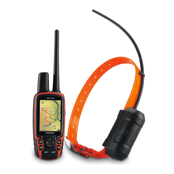
Introduction Device Overviews Astro notice Avoid using a high-powered radio (greater than 5 watts) in close proximity to the Astro. It may cause irreversible damage to the Astro. ➊ ➋ ➌ ➍ ➎ GPS antenna ➊ VHF antenna ➋ ➌ Display ➍... - Page 9 DC 40 ➋ ➌ Astro 320 and DC40 Owner’s Manual ➊ ➋ ➌ ➊ ➍ Keypad MARK BACK ➍ Introduction VHF antenna Collar GPS antenna Power key Press to view the Dog Tracker page. Press to mark your current location. Press to cancel data entry or return to the previous menu or page.
-
Page 10: Adjusting The Backlight
Introduction MENU Press to open the menu for the active page. Press twice to open the main menu. ENTER Press to select options and acknowledge messages. Rocker Press to view or scroll through options and to move the map pointer. Press to zoom in on the map. -
Page 11: Status Information
Scroll A bar that appears on the right side of a list that is too long to fit on the screen. Use the Rocker to scroll through a list. Press IN or OUT to scroll a set of items. Default The original factory settings. -
Page 12: Using The On-Screen Keyboard
Introduction Using the On-Screen Keyboard A keyboard appears when you enter text. • Use the Rocker to select a character, and press ENTER. • Select to backspace. • Select to shift. • Press IN or OUT to change the character mode of the keyboard. •... -
Page 13: Tracking Your Dog
Tracking Your Dog NOTE: The DC 40 does not transmit its location to the Astro, and the Astro does not indicate the location of the DC 40, until both devices have acquired satellite signals. Communication with the DC 40 The DC 40 that was packaged with your Astro was linked with the Astro at the factory. -
Page 14: Dog Status Icons
Tracking Your Dog ➊ ➋ ➌ Dog pointer (direction to ➊ the dog) Dog name ➋ Dog status icon ➌ Distance to the dog ➍ 2. If you have additional dogs, use the Rocker to scroll through the list of dogs. -
Page 15: Editing Dog Information
Treed Unknown* *The unknown status icon indicates that the DC 40 has not acquired a satellite signal and that the Astro cannot determine the location of the dog. Editing Dog Information The Astro assigns a default name, “Dog,” to the DC 40 packaged with the Astro. -
Page 16: Tracking Your Dog On The Map
Tracking Your Dog Tracking Your Dog on the Press MAP to follow your dog on the map. ➋ ➌ • The dog location icon appears with the dog name • The track of the dog’s movements appears as a red (color is customizable) line •... -
Page 17: Assigning A Dog Id Manually
3. Follow the on-screen instructions. Dog Signal Troubleshooting Each dog you track has its own ID number. If two dogs within range of the Astro have the same ID, the Astro warns you of a conflicting ID signal. Follow the on-screen instructions to resolve the conflict. -
Page 18: Collar Lock
Tracking Your Dog Collar Lock You can use the Collar Lock feature to PIN protect your dog’s ID signal. Other Astro users must enter the PIN in order to track your dog. Other Astro users can still add your dog by physically touching the Astro to the DC 40. - Page 19 • Go to www.garmin.com/products /astro for more information and www.garmin.com/astro tutorial. Pausing the Devices During a Hunt If you are moving the dogs during a hunt and you do not want to record the transportation of the dogs, you can pause the tracking of all dogs.
- Page 20 Tracking Your Dog About Line-of-Sight Radio Communication The Astro and DC 40 use radio signals to communicate. Objects in the path of radio signals degrade the quality of the signals. Keeping an unobstructed line of sight between your Astro and your dog’s DC 40 produces the best communication signal.
-
Page 21: Waypoints, Routes, And Tracks
Waypoints, Routes, and Tracks Waypoints Waypoints are locations you record and store in the device. After you mark a location with your Astro, it is saved as a waypoint. Marking Your Vehicle Location 1. From the main menu, select Start New Hunt. -
Page 22: Moving A Waypoint On The Map
Waypoints, Routes, and Tracks TIP: For navigation settings, see page Editing a Waypoint Before you can edit a waypoint, you must create a waypoint. 1. From the main menu, select Tools > Waypoint Mgr.. 2. Select a waypoint. 3. Select an attribute (such as the name). -
Page 23: Averaging Your Location
Deleting a Waypoint 1. From the main menu, select Tools > Waypoint Mgr.. 2. Select a waypoint. 3. Press MENU. 4. Select Delete > Yes. Repositioning a Waypoint You can change the position of a waypoint. For example, if you move your vehicle, you can change the location to your current position. -
Page 24: Routes
Waypoints, Routes, and Tracks Projecting a Waypoint You can create a new location by projecting the distance and bearing from a marked location to a new location. 1. From the main menu, select Tools > Waypoint Mgr.. 2. Select a waypoint. 3. -
Page 25: Viewing The Active Route
5. Select an option: • To view the point on the map, select Review. • To change the order of the point on the route, select Move Down or Move Up. • To add an additional point on the route, select Insert. The additional point is inserted before the point you are editing. -
Page 26: Recording Track Logs
Waypoints, Routes, and Tracks Recording Track Logs 1. From the main menu, select Setup > Tracks > Track Log. 2. Select Record, Do Not Show or Record, Show On Map. If you select Record, Show On Map, a line on the map indicates your track. -
Page 27: Marking A Location On A Saved Track
Digital Elevation Models Maps Using Digital Elevation Models (DEM) maps, you can create a track elevation profile that includes elevation data. Go www.garmin.com/cartography /ontheTrail for more information about US Topo maps. Saving the Entire Track Log 1. From the main menu, select Tools >... -
Page 28: Archiving Track Manually/Automatic
Waypoints, Routes, and Tracks Starting a TracBack You can use TracBack ® track to navigate back to the beginning of a track. This can be helpful when finding your way back to camp or your vehicle. 1. From the main menu, select Tools > Track Manager. -
Page 29: Sharing Data Wirelessly
Sharing Data Wirelessly Before you can share data wirelessly, you must be within 10 feet (3 m) of a compatible Garmin device. Sharing Waypoints, geocaches, Routes, and Tracks 1. From the main menu, select Tools > Share Wirelessly. 2. Select Send or Receive. -
Page 30: Map
The example shows enhanced map detail using City Navigator . Go to www.garmin.com. ® position icon represents your location on the map. As you travel, the position icon moves and leaves a track log (trail). -
Page 31: Measuring Distance
Measuring Distance You can measure the distance between two points. 1. Press MAP > MENU. 2. Select Measure Distance. An arrow appears at your current location. 3. Move the arrow to the point you want to measure from, and press ENTER. -
Page 32: Stopping Navigation
3. Select an item from the list. Finding Photos Before you can navigate to a photo with location information, you must download (http://my.garmin.com) or transfer a photo to the device (page 62). 1. From the main menu, select Find >... -
Page 33: Detailed Maps
The detailed maps contain millions of points of interest, such as restaurants, hotels, and auto services. Go to www.garmin.com/us/maps/. Finding an Address 1. From the main menu, select Find > Addresses. 2. Enter the state or province, city, street number, and street name. -
Page 34: Navigation Tools
Navigation Tools Navigation Tools Navigation tools include features that compliment the GPS functions of the Astro. • Compass (page • Sight ‘N Go (page • Trip computer (page • Elevation plot (page • Proximity alarms (page • Area calculation (page •... - Page 35 the bearing pointer points toward the top of the compass, you are traveling directly toward your destination. • The compass ring ➌ indicate North orientation. Navigating with the Course Pointer This is most useful if you are navigating on water or where there are no major obstacles in your path.
-
Page 36: Calibrating The Compass
Navigation Tools 2. Move back to the “course line to destination” to compensate for deviation and to get back on course. Calibrating the Compass notice Calibrate the electronic compass outdoors. Do not stand near objects that influence magnetic fields, such as cars, buildings, or overhead power lines. -
Page 37: Trip Computer
4. Select an option: • Select Set Course to navigate to the distant object. • Select Project Waypoint (page 24). Trip Computer The trip computer displays your current speed, average speed, maximum speed, trip odometer, and other helpful statistics. Customizing the Trip Computer 1. -
Page 38: Elevation Plot
Navigation Tools Elevation Plot By default, the elevation plot displays the elevation for distance. To customize the elevation plot, see page Viewing Points on the Elevation Plot 1. From the main menu, select Tools > Elevation Plot. 2. Press left or right on the Rocker to scroll across the plot. -
Page 39: Calibrating The Altimeter
2. Press MENU. 3. Select Adjust Zoom Ranges. 4. Use the Rocker to set the zoom range on the vertical axis. 5. Use the Rocker to set the zoom range on the horizontal axis. Calibrating the Altimeter 1. Go to a location where the elevation or barometric pressure is known. -
Page 40: Satellite
Navigation Tools 3. Select Calculate when finished.. 4. If necessary, select Change Units to change the units of measure. 5. Select Save Track. Satellite The satellite page shows your current location, GPS accuracy, satellite locations, and signal strength. Changing the Satellite View 1. -
Page 41: Device Tools
Device Tools Viewing the Calendar and Almanacs You can view device activity, such as when a waypoint was saved, and almanac information for the sun and moon, and hunting and fishing. 1. From the main menu, select Tools. 2. Select an option: •... -
Page 42: Alarm Clock
Device Tools Alarm Clock Setting an Alarm If you are not currently using the device, you can set the device to turn on at a specific time. 1. From the main menu, select Tools > Alarm Clock. 2. Select the time field to enter the time. -
Page 43: Filtering The Geocache List
Downloading geocaches 1. Connect your device to a computer (page 61). 2. Go to www.opencaching.com. 3. If necessary, create an account. 4. Sign in. 5. Follow the on-screen instructions. Finding a geocache Before you can navigate to a geocache, you must download (page wirelessly send a geocache to the device... - Page 44 2. Select a filter. 3. Select Edit Filter or Edit Name. chirp A chirp is a small Garmin accessory ™ that you can program and leave in a geocache. Only the owner of the chirp can program a chirp, but anyone can find a chirp in a geocache.
-
Page 45: Customizing Your Device
Customizing Your Device Customizing the Main Menu You can move, add, or delete items in the main menu. 1. From the main menu, press MENU. 2. Select Change Item Order. 3. Select a menu item. 4. Select an option: • Select Move and change the order of the list. -
Page 46: Customizing Dashboards
Customizing Your Device are saved automatically as part of the profile. Selecting a Profile 1. From the main menu, select Tools > Profile Change. 2. Select a profile. Creating a Custom Profile You can customize your settings and data fields for a particular activity or trip. -
Page 47: System Settings
WAAS/EGNOS (Wide Area Augmentation System/European Geostationary Navigation Overlay Service), or Demo Mode (GPS off). For information about WAAS, go to www.garmin.com/aboutGPS /waas.html. • Language—sets the text language on the device. NOTE: Changing the text language does not change the language of user-entered data or map data, such as street names. -
Page 48: Customizing The Dog List
Customizing Your Device ◦ GPS Lost Alert—indicates that the dog’s DC 40 has lost GPS satellite signals. ◦ Lost Communication Alert— indicates that the Astro is not receiving signals from the DC 40. Customizing the Dog List 1. From the main menu, press DOG twice. -
Page 49: Map Settings
Map Settings From the main menu, select Setup > Map. • Orientation ◦ North Up—shows north at the top of the page. ◦ Track Up—shows your current direction of travel toward the top of the page. • Guidance Text—allows you to select when to show guidance text on the map. -
Page 50: Tracks Settings
Customizing Your Device Tracks Settings From the main menu, select Setup > Tracks. • Track Log—turns track recording on or off. • Record Method—selects a track recording method. Auto records the tracks at a variable rate to create an optimum representation of your tracks. -
Page 51: Position Format
Position Format NOTE: Do not change the position format or the map datum coordinate system unless you are using a map or chart that specifies a different position format. From the main menu, select Setup > Position Format. • Position Format—sets the position format in which a given location reading appears. -
Page 52: Altimeter Settings
Customizing Your Device line leading to a destination. • Compass—switches from an electronic compass to a GPS compass when you are traveling at a higher rate of speed for a set period of time (Auto), or turns the compass off. •... -
Page 53: Geocache Settings
• Guidance Method—allows you to select a guidance method for calculating your route. ◦ Off Road—calculates point-to- point routes. ◦ On Road For Time (requires routable maps)—calculates onroad routes that require minimal time to drive. Customizing Your Device —programs the ™ www.garmin... -
Page 54: Marine Settings
Customizing Your Device ◦ On Road For Distance (requires routable maps)— calculates on-road routes that are shorter in distance. ◦ Prompted—asks you to select a routing method before the route is calculated. • Follow Road Method—allows you to select a transportation method in order to optimize your route. -
Page 55: Setting Up Marine Alarms
◦ Fishing—(requires marine maps) displays a detailed view of bottom contours and depth soundings. Simplifies map presentation for optimal use while fishing. • Appearance—allows you to set the appearance of marine navigation aids on the map. • Marine Alarm Setup ◦... -
Page 56: Device Information
Device Information Device Information Viewing Device Information You can view the unit ID, software version, and license agreement. From the main menu, select Setup > About. Caring for the Devices notice Avoid chemical cleaners and solvents that can damage plastic components. Cleaning the Devices 1. -
Page 57: Specifications
Specifications Astro Water Water resistant to resistance IEC 60529 IPX7 Battery type Two 1.5 volt AA batteries (alkaline, NiMH, or lithium) Alkaline Up to 15 hours, battery life typical usage NiMH or Up to 20 hours, lithium typical usage battery life Operating From -4°F to 158°F temperature... -
Page 58: Battery Information
Device Information Battery Information WARNINg See the Important Safety and Product Information guide in the product box for product warnings and other important information. CAUTION The temperature rating for the device may exceed the usable range of some batteries. -
Page 59: Maximizing Battery Life
capacity and store it in a cool, dry location where temperatures are not expected to exceed typical household levels. • Do not store a fully depleted battery because it may not recharge after an extended period of storage. • After storage, fully charge the battery again before using the DC 40. -
Page 60: Data Management
You can purchase microSD memory cards from an electronics supplier, or purchase preloaded map data cards from your Garmin dealer. In addition to map and data storage, the memory cards can be used to store files such as images, cartridges, geocaches, routes, OS 10.3... -
Page 61: Connecting The Usb Cable
5. Push in and slide down the metal cover. 6. Replace the batteries and the battery cover. Removing a microSD Card 1. Slide up and pull out the metal cover. 2. Remove the card from the slot. 3. Push in and slide down the metal cover. -
Page 62: Transferring Files
USB drivers from www.garmin.com. 1. Browse your computer for the file. 2. Select the file. 3. Select Edit > Copy. 4. Open the “Garmin” or memory card drive or volume. TIP: You must put photo files in the Garmin\JPEG folder. You must put geocache files in the Garmin\GPX folder. -
Page 63: Updating The Device Software
Before you can delete files, you must connect the device to your computer (page 61). 1. Open the “Garmin” drive or volume. 2. If necessary, open a folder or volume. 3. Select the files. Astro 320 and DC40 Owner’s Manual Device Information 4. - Page 64 Device Information 3. Check for DC 40 software updates. The DC 40 software is stored on your Astro until you are ready to load it wirelessly. Loading the DC 40 Software Before you can load the software to the DC 40, you must get the software from WebUpdater.
-
Page 65: Appendix
Points of Interest (POIs) and other useful items. • Unlock optional maps. • Download geocaches to your device. Buying Accessories Go to http://buy.garmin.com, or contact your Garmin dealer for information about optional accessories, preloaded map data cards, accessories, and replacement parts. Appendix... -
Page 66: Using Optional Fitness Accessories
• After you pair the first time, your Garmin device automatically recognizes the ANT+ accessory each time it is activated. This process occurs automatically when you turn on the Garmin device and Astro 320 and DC40 Owner’s Manual 69). -
Page 67: Optional Maps
• When paired, your Garmin device receives data from only your accessory, and you can go near other accessories. Optional Maps You can purchase additional maps, such as BirdsEye satellite imagery, ™... -
Page 68: Changing The Fuse In The Vehicle Power Cable
Appendix Replacing the DC 40 VHF Antenna Before you can replace the VHF antenna, you must detach the DC 40 from the collar (page 67). 1. Remove the weather cap and screw from the VHF antenna. 2. Remove the old VHF antenna. 3. -
Page 69: Data Field Options
Data Field Options Data Field Description Accuracy of The margin of error for your exact location. For example, your GPS location is accurate to within +/- 12 feet. Ambient The uncalibrated Pressure environmental pressure. Ascent - The average vertical Average distance of ascent. - Page 70 Appendix Data Field Description Elevation The altitude of your current location above or below sea level. Elevation - The highest elevation Maximum reached. Elevation - The lowest elevation Minimum reached. ETA at The estimated time Destination of day you will reach your final destination.
- Page 71 Data Field Description Odometer A running tally of distance traveled for all trips. Off Course The distance to the left or the right by which you have strayed from the original path of travel. Pointer The data field arrow points in the direction of the next point or turn.
- Page 72 Appendix Data Field Description Trip Odometer A running tally of the distance traveled since the last reset. Trip Time - A running tally of time Moving since the last reset. Trip Time - The time spent not Stopped moving since the last reset.
-
Page 73: Troubleshooting
2. Turn on the device. 3. Remain stationary for several minutes. To learn how to maximize the battery life, see On the device, the Garmin logo and appear. On your computer, you should see a new removable disk drive in My Computer on Windows computers and a mounted volume on Mac computers. - Page 74 If you have several network drives mapped on your computer, Windows may have trouble assigning drive letters to your Garmin drives. See the Help file for your operating system to learn how to assign drive letters. Go to http://buy.garmin.com, or contact your Garmin dealer.
-
Page 75: Index
Index accessories adding a dog addresses alarms clock marine proximity tones alerts vibration almanacs altimeter calibrating navigating settings 52, 56 averaging your location backlight 10, 48, 59 barometer 52, 69 Astro 320 and DC40 Owner’s Manual batteries installing life 11, 57 replacing storage type... - Page 76 22, 32 fitness accessories fixed elevation Garmin Product Support geocaches settings sharing settings signals 11, 40, 69 heading settings keyboard keypad language line-of-sight radio communication main menu...
- Page 77 Sight ‘N Go stopping to a destination waypoints odometer POI Loader points of interest position format power key 8, 9 product support profiles proximity alarms radio signals recent finds replacement parts routes editing settings Astro 320 and DC40 Owner’s Manual satellite page satellite signals 11, 13,...
- Page 80 For the latest free software updates (excluding map data) throughout the life of your garmin products, visit the garmin Web site at www.garmin.com. © 2011 Garmin Ltd. or its subsidiaries Garmin International, Inc. 1200 East 151 Street, Olathe, Kansas 66062, USA Garmin (Europe) Ltd.
Need help?
Do you have a question about the Astro 320 and is the answer not in the manual?
Questions and answers