
Subscribe to Our Youtube Channel
Related Manuals for IDS GeoRadar STREAM DP

Summary of Contents for IDS GeoRadar STREAM DP
- Page 1 User Manual STREAM DP using GPR AE32HV User Manual Installation and use IDS Geo ORIGINAL INSTRUCTION IN ENGLISH LANGUAGE MNG/2022/007 Rev. 1.0 June 2022 User Manual...
- Page 2 STREAM DP User Manual – Rev. 1.0 – User Manual Mod: MDM/011/M2 Rev8 IDS GeoRadar Srl MNG/2022/007 Rev. 1.0 2/ 36...
- Page 3 Use of the Manual This Manual is intended to be used solely by authorized user of IDS GeoRadar Systems. It is specific for internal business purpose only. If you are not an authorized user, you are NOT allowed to read this Manual and you must return it to IDS GeoRadar as soon as possible. Access to and use of this Manual is also provided subject to the acceptance of the Disclaimer set out below.
-
Page 4: Table Of Contents
HEEL BLOCKAGE SYSTEM ..........................................21 DJUSTABLE AND REMOVABLE HANDLE ................................................22 SUPPORT POLE 4.10 ............................................23 ATA LOGGER SPECIFICATIONS 4.11 ................................................23 APTOP SUPPORT 4.12 ......................................... 24 OW THE SYSTEM IS DELIVERED AND PACKED IDS GeoRadar Srl MNG/2022/007 Rev. 1.0 4/ 36... - Page 5 INDEX Mod: MDM/011/M2 Rev8 HOW TO ASSEMBLE THE SYSTEM AND SAFETY GUIDELINES ..................................24 HOW TO SET UP THE STREAM DP IN TRANSPORT MODE ...................................26 ............................................... 26 OLDING THE HANDLE .............................................. 26 ISASSEMBLING THE SYSTEM CARE AND TRANSPORT .............................................28 ..............................................28...
-
Page 6: Introduction
Germany: The purpose of this document is to drive the reader to a list of step-by-step https://www.bundesnetzagentur.de/SharedDocs/Downloads/DE/Sachgebie actions to follow in order to install Stream DP system, in a thorough and safe way. te/Telekommunikation/Unternehmen_Institutionen/Technik/Inverkehrbrin genvonProdukten/Schnittstellenbeschreibungen/OrtungsfunkOR/SSBOR_N The structure of the manual is organized in a collection of "how-to" as well N022.pdf?__blob=publicationFile&v=4... -
Page 7: Ce Marking
Radio Equipment Regulations 2017 (S.I. 2017/1206). The full Declaration of its Conformity can be found either on the CD or a separate document included with this product. Licensing requirements found here: https://www.ofcom.org.uk/manage-your- licence/radiocommunication-licences/licensed-short-range IDS GeoRadar Srl MNG/2022/007 Rev. 1.0 7/ 36... -
Page 8: How To Read The Manual
Indicates an imminently hazardous situation which, to” manner. In each of the relevant chapter, the User shall find, action by if not avoided, will result in death or serious injury. action, the basics to carry out a Stream DP installation. DANGER 2.1 Manual Layout... -
Page 9: Glossary & Acronyms
NMEA format: National Marine Electronics Association format RTK: Real Time Kinematic SNR: Signal to Noise Ratio Stream DP: IDS GeoRadar GPR massive Array System SW: Software UBLOX: GPS dispositive within the GPR system uMap: IDS GeoRadar software for GPR data acquisition IDS GeoRadar Srl MNG/2022/007 Rev. -
Page 10: Safety Directions
• Optic fibre • Electric cables 3.5 Responsibilities • Telephone cables Manufacturer of the product - IDS GeoRadar s.r.l. is responsible for supplying • Manholes the product, including the user manual and original accessories, in a safe • Cavities •... - Page 11 Precautions: Periodically carry out test measurements, particularly after the product has been subjected to abnormal use and before and after of important measurements. IDS GeoRadar Srl MNG/2022/007 Rev. 1.0 11/ 36...
-
Page 12: Hazard Of Use
PRECAUTIONS: Always ensure that the working site is adequately secured. Adhere to the regulations governing safety, accident prevention, and road traffic. IDS GeoRadar Srl MNG/2022/007 Rev. 1.0 12/ 36... - Page 13 IDS GeoRadar and and international rules and regulations are observed. Before follow the system that IDS GeoRadar has set up to permit the transportation or shipping, please contact your local passenger separate collection of the apparatus at its life end.
- Page 14 WARNING: Battery may get hot after prolonged use. Risk of burning injuries. PRECAUTIONS: Avoid touching the hot battery. Allow the battery to cool down before removing it. IDS GeoRadar Srl MNG/2022/007 Rev. 1.0 14/ 36...
-
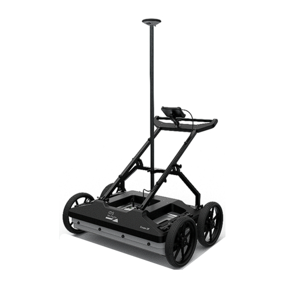
Page 15: General Description Of The Hardware
Stream DP’s antenna height can be adjusted manually from the user through 4 GENERAL DESCRIPTION OF THE HARDWARE a belts system. The Stream DP is a GPR system composed of a single antenna (named GPR AE32HV) fixed to a compact and manoeuvrable frame. 4.1 E.s.T. Equalized scrambled Technology... - Page 16 4 GENERAL DESCRIPTION OF THE HARDWARE Mod: MDM/011/M2 Rev 8 Stream DP dimensions are reported on the following pictures (Fig. 3 and Fig. Fig. 1 – Stream DP Rugged configuration Fig. 3 – Stream DP side view Fig. 2 – Stream DP Asphalt configuration IDS GeoRadar Srl MNG/2022/007 Rev.
- Page 17 4 GENERAL DESCRIPTION OF THE HARDWARE Mod: MDM/011/M2 Rev 8 Fig. 4 – Stream DP rear view IDS GeoRadar Srl MNG/2022/007 Rev. 1.0 17/ 36...
-
Page 18: Mechanical Structure
Vehicle Towing kit (accessory) This chapter contains a description of the above-listed parts. The whole system is shown in Fig. 5. Fig. 6 - Stream DP sub-components Every part of the system weighs less than 20 kg. Fig. 5 - Stream DP overview IDS GeoRadar Srl MNG/2022/007 Rev. -
Page 19: Connection And Ports
Power out (PWR): enables the power supply on Stream DP accessories Synchronism and Positioning (SYNC): transfer PPS and wheel data to an external device, or receive external PPS as input to Stream DP. Power-On button: push to switch the system on; LED status indicators: system on and batteries status;... -
Page 20: Wheel Types
4.7 Wheel blockage system A braking system to lock/unlock the system is mounted on the front wheels of the Stream DP, to secure the stop position when the radar is in non- operative mode. Users can activate the brakes manually, simply moving the lever (Fig. 11). -
Page 21: Adjustable And Removable Handle
CAUTION Stream DP handle can be also completely removed to facilitate the carriage. Taking out the two inclination pins and the four pins on the main frame (Fig. 13), the handle will be disassembled in two parts. -
Page 22: Gps Support Pole
(Fig. 14) and pressing the plastic buttons on the pole (Fig. 15). Fig. 16 - Clamp system for GNSS pole GNSS receiver has to be tightened on the thread (Fig. 17). Fig. 14 - Removing the plastic bushing IDS GeoRadar Srl MNG/2022/007 Rev. 1.0 22/ 36... -
Page 23: Data Logger Specifications
Fig. 19 - How to adjust laptop support Then, the user can insert the tablet and release the right part to secure the tablet (Fig. 18). IDS GeoRadar Srl MNG/2022/007 Rev. 1.0 23/ 36... -
Page 24: How The System Is Delivered And Packed
5 HOW TO ASSEMBLE THE SYSTEM AND SAFETY GUIDELINES Mod: MDM/011/M2 Rev 8 4.12 How the system is delivered and packed Stream DP components are delivered in a packaging foam on a pallet (Fig. 20). Fig. 21 – Wheel button 2. - Page 25 10. Connect the LAN cable from the antenna to the tablet port (Fig. 23) Fig. 23 - Connection overview 11. Turn the system on (Fig. 24) Fig. 24 - Stream DP operative mode 12. Launch uMap software on the data logger IDS GeoRadar Srl MNG/2022/007 Rev.
-
Page 26: How To Set Up The Stream Dp In Transport Mode
6 HOW TO SET UP THE STREAM DP IN TRANSPORT MODE Mod: MDM/011/M2 Rev 8 6 HOW TO SET UP THE STREAM DP IN TRANSPORT MODE Stream DP can be carried away in two options: • Folding the handle •... - Page 27 6 HOW TO SET UP THE STREAM DP IN TRANSPORT MODE Mod: MDM/011/M2 Rev 8 Fig. 27 - Ergonomic slot (one operator) Fig. 28 - Ergonomic slots (two operators) IDS GeoRadar Srl MNG/2022/007 Rev. 1.0 27/ 36...
-
Page 28: Care And Transport
7.3 Periodical Check The Operator should periodically check the status of the antenna sledge, The Stream DP should be cleaned periodically using a damp cloth. shells, all cables, and tires, any rotating part, and any (potentially) consumable part. The system must not be used in case of any malfunctioning... -
Page 29: Transport Of The System
In case of any deviation from the above either, inflate the tires and/or shipped by using the flight case with which the system and/or replace it, as deemed. is delivered. • • IDS GeoRadar Srl MNG/2022/007 Rev. 1.0 29/ 36... -
Page 30: Appendix Adisclaimer
Pisa. In no event IDS GeoRadar S.r.l. shall be liable for special, direct, Initial Precautions for Setting-up and Use of the Products. indirect, incidental, exemplary, punitive or consequential damages... - Page 31 GeoRadar S.r.l. combination with other products, including but not limited to the following main aspects: a. Use of IDS GeoRadar S.r.l. Products outside its limitation of use, without proper and adequate scientific/technical knowledge or without specific training. b. Use of results/outcomes of the measurements performed...
-
Page 32: Appendix Btechnical Specifications
IQMaps Advanced 3D processing software with Sensor Frequency 600MHz Processing Software a direct export link to AutoCAD Weight 42Kg Stream DP System Size 116X82 cm Scan Width 83 cm Number of channels 30 (19VV-11HH) Power Consumption Acquisition:19W; Stand-by:15W Max Operating Time... -
Page 33: Appendix Cconformity To European And Uk Regulations
CONFORMITY TO EUROPEAN and UK REGULATIONS EC DECLARATION OF CONFORMITY UKCA DECLARATION OF CONFORMITY IDS Georadar s.r.l. IDS Georadar s.r.l. via A. Righi, 6, 6 A, 8, 56121 PISA, ITALY via A. Righi, 6, 6 A, 8, 56121 PISA, ITALY... -
Page 34: Appendix Dimportant Note For Us Customers
This device devices may not be employed for the operation of toys. nomenclature of the UWB device. This material shall be submitted to the following Operation onboard an aircraft, a ship or a satellite is prohibited. address: Frequency Coordination Branch., OET IDS GeoRadar Srl MNG/2022/007 Rev. 1.0 34/ 36... -
Page 35: Appendix Eimportant Notes For Canadian Customers
Canada. L’exploitation est soumise aux deux conditions suivantes : 1. Cet appareil ne peut pas causer d’interférence. 2. Cet appareil doit accepter toute interférence, y compris les interférences qui peuvent provoquer un fonctionnement indésirable de l’appareil. IDS GeoRadar Srl MNG/2022/007 Rev. 1.0 35/ 36... -
Page 36: Appendix Fcontacts
APPENDIX F CONTACTS Mod: MDM/011/M2 Rev 8 APPENDIX F CONTACTS The IDS GeoRadar Support team is available to answer any question about: • general enquiries • request of advertising material • technical issues • As well as listening to your suggestions too.
Need help?
Do you have a question about the STREAM DP and is the answer not in the manual?
Questions and answers
please give a step-by-step setup of a job sample. form setting up to starting the scan task.
To set up a job sample for the IDS GeoRadar STREAM DP and begin a scan task, follow these steps:
1. Fix four wheels to the main body.
2. Fit the frame into the antenna’s inserts.
3. Secure the antenna using four hooks on the lifting system.
4. Adjust the antenna height from the ground using the lifting system.
5. Mount the handle by fixing six pins (four short on the main frame, two long on the central rudder).
6. Install the tablet on its support.
7. (Optional) Install the GPS pole.
8. Open the battery compartment by loosening the screw; insert up to two batteries.
9. Connect the two-wheel cables and turn ¼ to fasten.
10. Connect the LAN cable from the antenna to the tablet port.
11. Turn the system on.
After completing these steps, the system is ready to start the scan task.
This answer is automatically generated
Can I use Umap software to interpret scan data
Yes, uMap software can be used to interpret scan data from IDS GeoRadar STREAM DP. It provides automatic calibration for easy start-up, visualization and storage of antenna array data, and real-time visualization of radar tomography (time slices).
This answer is automatically generated