Advertisement
Quick Links
2015-06-24
Unofficial illustrated
X-Plane 10
GPS 530
Quick Reference
X-Plane is a product of Laminar Research, see http://www.laminarresearch.com and http://www.x-plane.com
All screenshots for this document have been created using X-Plane 10.36 (64-bit) on Microsoft Windows 7 Prof., 64-bit
The PC-12 screenshot has been created using Shade-Tree-Micro-Aviation PC-12 Model 12.47g (see http://www.shadetreemicro.com)
All rights belong to their respective owners.
This document is not to be used for real navigation.
It is aimed at flight simulation enthusiasts.
This document is provided „as-is", without any express or implied warranty. In no event will the author be held liable for any
damages arising from the use of this document.
- Not to be used for real navigation -
Advertisement

Related Manuals for Laminar Research X-Plane 530

Summary of Contents for Laminar Research X-Plane 530
- Page 1 GPS 530 Quick Reference X-Plane is a product of Laminar Research, see http://www.laminarresearch.com and http://www.x-plane.com All screenshots for this document have been created using X-Plane 10.36 (64-bit) on Microsoft Windows 7 Prof., 64-bit The PC-12 screenshot has been created using Shade-Tree-Micro-Aviation PC-12 Model 12.47g (see http://www.shadetreemicro.com) All rights belong to their respective owners.
- Page 2 2015-06-24 Table of Contents Default Display Resetting the view Setting COM and NAV frequencies Map scaling Switching page modes NAV mode pages WPT mode pages NRST mode pages Navigating to NRST waypoint Using a flight plan adding a waypoint to the flight plan deleting a waypoint from the flight plan loading an existing flight plan Activating a leg...
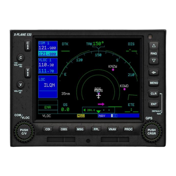
- Page 3 2015-06-24 Direct Current Default Distance to tracking to tracking of COM 1 waypoint in Display waypoint aircraft Frequency NAV 1 Frequency Compass rose ID, Radial and distance to Flight plan currently path selected VOR (from VLOC 1), if it is in range Estimated time of arrival at...
- Page 4 2015-06-24 Resetting the view If you get lost in the menu structure, press and hold the CLR key until you get returned to this NAV / 1 mode page (approx. 10 seconds) - Not to be used for real navigation -...
- Page 5 2015-06-24 Setting COM and NAV frequencies This part display settings for COM 1 radio Pressing this The active frequency is button swaps 122.800, the standby active and frequency is 121.000 standby COM 1 frequencies Pressing this button swaps active and This highlighted field can be modified standby NAV 1 when turning the inner or outer knob...
- Page 6 Map scaling 2015-06-24 Using the range up/down buttons the map scaling can be changed from 1 nm to 1500 nm Using the CLR button (works multiple times) the map can be decluttered (the results are not shown) - Not to be used for real navigation -...
- Page 7 2015-06-24 Switching page modes Use the outer knob to toggle between page groups NAV, WPT and NRST. Use the inner knob to toggle between sub pages within the same group. Note that the last selected page within each group will be remembered on reentering. - Not to be used for real navigation -...
- Page 8 NAV mode pages 2015-06-24 The additional NAV pages deliver more information about the next waypoint and vertical navigation settings. - Not to be used for real navigation -...
- Page 9 WPT (waypoint) mode pages 2015-06-24 These WPT pages deliver additional information about the airport, e.g. name, location, runways, frequencies, ILS - Not to be used for real navigation -...
- Page 10 NRST (nearest) mode pages 2015-06-24 These NRST pages deliver additional information about the nearest airports, intersections, NDBs, ... - Not to be used for real navigation -...
- Page 11 2015-06-24 NRST (nearest) mode pages (continued) ... VORs, and airspaces. - Not to be used for real navigation -...
- Page 12 2015-06-24 Navigating to NRST Then press waypoint Direct-To button to display details on next page Push knob to activate cursor and then turn it to highlight an entry Press ENTER button button to confirm or CLR to abort Now going to FSB Pressing FPL shows flightplan has been deleted, now contains only new waypoint - Not to be used for real navigation -...
- Page 13 2015-06-24 Using a flight plan Pressing the FPL button toggles the display of this flight plan page showing the waypoints (airports, navaids, intersections, ...) with ID, direct tracking course, distance, cumulated distance, ..- Not to be used for real navigation -...
- Page 14 2015-06-24 Using a flight plan (continued) Finally press the ENTER key. Pressing the Menu button activates the above menu. To start cleanly, the current flight plan can be deleted. During flight, the approach can be deleted, or another leg can be activated. Use the right bottom knob to highlight the required entry - Not to be used for real navigation -...
- Page 15 2015-06-24 Adding a waypoint to the flight plan Then turn the outer Push knob to activate knob to highlight the cursor entry in front of which the new waypoint shall be added ..then turn the inner knob once to bring up the waypoint entry page - Not to be used for real navigation -...
- Page 16 2015-06-24 Adding a waypoint to the flight plan (continued) Starting off with letter K ..turning the inner knob ... turning the inner counter clockwise returns knob clockwise returns prior letter J the next letter L - Not to be used for real navigation -...
- Page 17 2015-06-24 Adding a waypoint to the flight plan (continued) Assuming cursor position is on the 2nd character ..turning the outer knob ... turning the outer counter clockwise moves knob clockwise moves the cursor position to the the cursor position to left (for corrections) the right ...
- Page 18 2015-06-24 Adding a waypoint to the flight plan (continued) Once finished, press the ENTER key; depending on the kind of waypoint this can take up to 5 characters (typical sizes: VOR: 3, NDB: 3, Airport: 4, Intersections 5) Another press of ENTER confirms the The new waypoint is entry.
- Page 19 2015-06-24 Deleting a waypoint from the flight plan Finally press CLR button Then turn the outer knob to Push knob to activate highlight the entry that shall be cursor deleted Finally press ENTER button to confirm The deleted waypoint is no longer Turn the knob to highlight either Yes or No part of the list.
- Page 20 2015-06-24 Loading an existing flight plan With no entry highlighted, turn the inner knob to activate the flight plan catalog. In case an entry is highlighted, press the knob prior to turning in order to hide the cursor Push the knob to activate the cursor highlighting, if required Finally hit ENTER to load the flight plan.
- Page 21 2015-06-24 Activating a leg of the flight plan Push knob to activate Then turn the outer cursor knob to highlight the required entry Press the Menu button, select Activate Leg, and press ENTER button The new leg should be active now - Not to be used for real navigation -...
- Page 22 2015-06-24 Going DIRECT to a waypoint of the flight plan Push knob to activate Then turn the outer cursor knob to highlight the required entry Press the Direct-To button Activate it pressing the ENTER button. Note that any waypoints prior to the one selected, will be removed from the flightplan - Not to be used for real navigation -...
- Page 23 2015-06-24 Adding an approach to the flight plan Then turn the knob to highlight the Select Push the PROC button Approach entry and press ENTER button Turn the knob to highlight the Turn the knob to highlight the required transition for the selected required approach wrt.
- Page 24 2015-06-24 Adding an approach to the flight plan (continued) Once flightplan is selected by pressing FPL button and scrolled down to the end using the outer knob ... Turn the knob to select from either LOAD or ACTIVATE, then press ENTER button Remember that it can be deleted later in ...
- Page 25 2015-06-24 Using Vertical Navigation (VNAV) Note that the current GPS does not support automated climb and / or descent control based on altitude restrictions assigned to some or all of the waypoints of the flight plan (+/- some offset) as it is provided by some of the Flight management computers (FMC) of larger Jet aircrafts.
- Page 26 2015-06-24 Using Vertical Navigation (VNAV, continued) Pressing the knob toggles highlighting of the active field. While a field is highlighted, turning the outer knob Pressing the VNAV button moves to the previous / next field; toggles the display of the turning the inner knob changes its above vertical navigation page.
- Page 27 Using the GPS 530 in a STMA Pilatus PC-12 (example) 2015-06-24 Autopilot must be turned on The selector must be set to GPS1 (not GPS 2) AP NAV Mode must be engaged Only the upper GPS 530 is used for LNAV (of course, it configures Com1 and Nav1 frequencies as well).
- Page 28 2015-06-24 Using the GPS 530 with other aircraft In order to use the GPS 530 for LNAV with other aircraft the following recommendations can be given: Make sure a GPS flight plan is loaded and a leg of it is active or, a Direct-To is active. The GPS CDS selection on left bottom side should show „GPS“...
-
Page 29: General Hints
2015-06-24 General hints Since the GPS 530 does not include support for SID (Standard Instrument Departure), you may want to add waypoints for a SID using some external Flight planning software: It is possible to achieve this using Plan-G by definition of user defined waypoints, where no intersections are available.
Need help?
Do you have a question about the X-Plane 530 and is the answer not in the manual?
Questions and answers