Table of Contents
Advertisement
Quick Links
Advertisement
Table of Contents

Related Manuals for SPE MARPO Dredger

Summary of Contents for SPE MARPO Dredger
- Page 1 MARPO_Dredger Version 9.16.1 Instruction Manual...
- Page 2 SPE GMBH & CO. KG Dredge Control Survey Engineering Ritscherstraße 5, 21244 Buchholz, Tel.: +49 40-390 63 55, Fax: +49 40-390 63 36, info@spe-electronics.de, www.spe-electronics.de Hamburg office: Klopstockstr. 11-13, 22765 Hamburg Document version created on: 25. June 2019...
-
Page 3: Table Of Contents
MARPO_Dredger instruction manual Contents PRELIMINARY REMARKS ................1 OVERVIEW ....................2 PLAN VIEW ....................3 Colour scale Mining depth ................5 Depth display echo sounder ................. 5 Position symbols ................... 5 Data Display Mode ..................5 Compass ......................5 Colour scale Terrain model ................6 Scale ...................... - Page 4 MARPO_Dredger instruction manual 5.10 Full screen mode ..................34 5.11 Additional functions ................... 35 5.11.1 Plan ..................... 36 5.11.2 DXF/DWG .................... 41 5.11.3 Marks ....................42 5.11.4 GeoTif ....................44 5.11.5 Service ....................44 5.11.6 Survey ....................44 5.11.7 Status ....................44 5.11.8 Target Offset ..................
-
Page 5: Preliminary Remarks
Preliminary remarks MARPO_Dredger instruction manual PRELIMINARY REMARKS The software MARPO_Dredger is part of the MARPO_DGPS_K extraction monitoring system. It is able to display and save positions and extraction depths of the excavation tool of a dredger during the dredging process in a mining area. This instruction manual describes the operation and function of MARPO_Dredger. -
Page 6: Overview
Overview MARPO_Dredger instruction manual OVERVIEW Plan view page 3 Profile view page 13 Navigation bar page 16 Status display page 17 Zoom function page 18 Menu for the Plan view page 19 Menu für die Profile view (Cut) page 21 Project menu page 25 Auxiliary menu... -
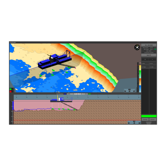
Page 7: Plan View
Plan View MARPO_Dredger instruction manual PLAN VIEW The upper part of the screen is called the plan view. It contains the digital terrain model (DTM), which is created by using survey data, approval limits and a digital dredger model. The plan view is a flexible 3D-visualisation, which allows the user to get a preferably flexible and individual observation of the mining area. - Page 8 Plan View MARPO_Dredger instruction manual In the following figure, the main components of the plan view are marked with numbers and listed in the table below. Colour scale Mining depth Page 5 Depth display Echo sounder Page 5 Position symbols Page 5 Data display mode Page 5...
-
Page 9: Colour Scale Mining Depth
Plan View MARPO_Dredger instruction manual Colour scale Mining depth The colour scale refers to the current distance in meters to the target horizon (excavation limit). Above the target horizon, the status is displayed in green and below in red. The adjustment of the colours is described in section 3.8. -
Page 10: Colour Scale Terrain Model
Plan View MARPO_Dredger instruction manual Colour scale Terrain model The colour scale is used as a visual tool to quickly distinguish between different depth zones. In the Terrain view, the DTM is displayed in different colours with reference to the height values. The red line below the value "0.00" symbolises the water level. -
Page 11: Scale
Plan View MARPO_Dredger instruction manual The value Lower (here: -18.70 m) defines the lower edge of the target horizon (mining limit) and is usually set to 2 m below the actual target horizon. The red arrow marks the boundary between land and water. By default it is positioned between the colours brown and yellow. - Page 12 Plan View MARPO_Dredger instruction manual In addition to the colour scale and the colours themselves, there is another menu option to be changed. The colour scale of the mining depth (see section 3.1) can be adjusted by double left clicking onto the colour scale of the Button Mining Thickness. The four colour boxes at the right end of the colour scale represent the colour scale of the mining depth.
-
Page 13: Grid Coordinate Mode
Plan View MARPO_Dredger instruction manual Grid Coordinate Mode This mode hides the surface of the DTM and displays the grid points only. Therefore a colour scale is not available here. Grid points are created as soon as depth values are recorded by the loosening tool or the echo sounders. -
Page 14: Box Cut Mode (Optional)
Plan View MARPO_Dredger instruction manual 3.10 Box Cut mode (optional) The Box Cut mode is similar to the Mining Thickness mode. In this mode, however, the coloured reference is not used to indicate the material left above the target horizon/ mining limit (red line), but to an intersecting or overlying stepped slope (green line). - Page 15 Plan View MARPO_Dredger instruction manual The Mining Thickness Mode shows the colours in relation to the mining limit (see section 3.8):...
-
Page 16: Data Display Mode: Mining, Sounder Data, Origin
Plan View MARPO_Dredger instruction manual 3.11 Data display mode: mining, sounder data, origin The coloured area of the plan view in the display Terrain (section 3) and Mining Thickness (see section 3.8) can be related to the depths of the Mining data, the Sounders data or the Originating DTM (initial DTM, which is defined in the program for this project, without taking into account mining or sonar data). -
Page 17: Profile View
Profile View MARPO_Dredger instruction manual PROFILE VIEW The lower view in MARPO_Dredger is called the Profile View. It is a two-dimensional view in which the cut is placed directly through the loosening tool. Depth scale Page 14 Page 14Fehler! Auxiliary line of the loosening tool Textmarke depth nicht... -
Page 18: Depth Scale
Profile View MARPO_Dredger instruction manual Depth scale The depth scale is a scale for orientation in depth. (Unit of measurement: Meter) The water level is the zero here. Auxiliary line loosening tool depth The auxiliary line is used for better detection of the current depth of the loosening tool. -
Page 19: Orientation Arrows
Profile View MARPO_Dredger instruction manual Orientation arrows The orientation arrows are used for orientation in the direction of the profile cut (see section 5.6). The blue-green line in the upper image (plan view) equals the orientation arrows in the lower image (profile view). The line does not only show the orientation of the profile cut, but also mirrors exactly the width of the lower view. -
Page 20: Menu Bar
Menu bar MARPO_Dredger instruction manual MENU BAR Water level display Page 17 Status display Page 17 Save mode Page 18 Zoom function Page 18 Menu for plan view Page 19 Menu for profile view Page 21 Project menu Page 25 Auxiliary menu Page 31 Status bar... -
Page 21: Water Level Display
Menu bar MARPO_Dredger instruction manual Water level display The water level is always entered and displayed as height above mean sea level (standard elevation zero). By clicking the button, the water level can be modified. Window for modifying the water level. IMPORTANT: Check input for plausibility to avoid incorrect data. -
Page 22: Save Mode
Menu bar MARPO_Dredger instruction manual Save mode This button activates or deactivates data recording. Saving activated. Saving disabled. Zoom function The function refers to the plan view and the profile view. Depending on which view is selected, the screen is enlarged or reduced. Enlarge view Reduce view Selecting a view... -
Page 23: Menu For Plan View
Menu bar MARPO_Dredger instruction manual Menu for plan view This menu is divided into the subcategories Plan up and View. The drawing of the plan view can be adjusted here. If the subcategories are not displayed, this can be done by clicking on Plan. -
Page 24: Plan Up
Menu bar MARPO_Dredger instruction manual 5.5.1 Plan up This submenu contains three setting options that determine the alignment and motion of the plan view. The green dot indicates the selected setting. The plan view is directed to the north. The view now can only be rotated around the horizontal axis. -
Page 25: Menu For Profile View
Menu bar MARPO_Dredger instruction manual Menu for profile view In this menu, the orientation of the profile cut view can be set to a given angle and the display of the material already been mined can be activated. The view can still be adjusted manually via the touch function or a mouse operation. - Page 26 Menu bar MARPO_Dredger instruction manual As can be seen by the orientation arrows, the profile is being cut from the rear in the direction of mining through the loosening tool. The profile is cut from port to starboard (seeing in the direction of mining from left to right).
- Page 27 Menu bar MARPO_Dredger instruction manual The profile is cut in the opposite direction to the direction of mining. The profile is cut from starboard to port (seeing in the direction of mining from right to left).
- Page 28 Menu bar MARPO_Dredger instruction manual Already mined material is displayed as a pink or orange area. Already mined material is not displayed.
-
Page 29: Project Menu
Menu bar MARPO_Dredger instruction manual Project menu The Project menu contains the project Settings and Selection as well as the Import and Export functions for projects. This submenu contains the settings for configuring and setting up the dredger model, the DTM, the echo sounders and the internal connection of the subsystems. -
Page 30: Select Project
Menu bar MARPO_Dredger instruction manual 5.7.1 Select project A project contains the DTM (digital terrain model) with the mining limits and the current state of the lake (e.g. by a hydrographic survey). As soon as a DTM is imported, MARPO_Dredger creates a project folder in which the DTM data and all recorded data are stored. - Page 31 Menu bar MARPO_Dredger instruction manual The following window now opens: The project to be imported can be selected there and added by clicking on Open in the lower right corner. Notice: A project always has the identifier "dgm_" followed by an abbreviation and the date of creation.
-
Page 32: Import Data
Menu bar MARPO_Dredger instruction manual Finally, the now imported project can be opened. This is done by clicking again on the button The desired project can now be selected with the mouse (or the touch screen) and it opens by clicking the Apply button. 5.7.2 Import data Internet: Import data stored in the e-mail box. -
Page 33: Export Data
Menu bar MARPO_Dredger instruction manual 5.7.3 Export data The export button can be used to export Mining Data, Sounder Data or Marks. After pressing one of the buttons, a window for specifying the export location is created. Here you can choose between different drives (e.g. C or Z). Mail is only configured with a remote maintenance option and requires an Internet connection. - Page 34 Menu bar MARPO_Dredger instruction manual In this window, you must select the time period to be exported. By default, the current month is selected. A single day/month/year or several days can be selected by simply clicking on them. Clicking the Apply button confirms the selection and starts the export. The created files are generated in the following format and with the following file name: General TYP_projectname_YYYYMMDD.zip...
-
Page 35: Auxiliary Menu
Menu bar MARPO_Dredger instruction manual Auxiliary menu... - Page 36 Opens/Closes the status message view at the bottom of the screen (below the profile view). Opens the MARPO_Monitor (see section 5.8.1). Status displays of the technical functionality and SPE-internal setting options. Night mode is activated. Opens a window with the following options:...
-
Page 37: Marpo_Monitor
Menu bar MARPO_Dredger instruction manual 5.8.1 MARPO_Monitor The MARPO Monitor is a status display of the technical functionality. Network connection to IPC is active. Network connection to MARPO_Dredger is active. MARPO_Control is not connected. (Not required) GPS NMEA data (position data) via IPC: Corrected position data GPS Differential Basic position data... -
Page 38: Status Bar
Menu bar MARPO_Dredger instruction manual Status bar The status bar reports the status of the DGPS receiver and (if configured) the Internet connection. Position detected / connection established Position incorrect / no connection GPS Internet connection ... -
Page 39: Additional Functions
Show system-specific data. Adjustment of the height of target horizon. Target Offset IMPORTANT: Use ONLY in consultation with site managers or SPE. Customer Execute Execution of a stored file. MARPO_Mobil is a mobile echo sounder sea survey device, available at... -
Page 40: Plan
Menu bar MARPO_Dredger instruction manual 5.11.1 Plan This menu item can be used to show or hide information within the plan view. Additional terrain information (e.g. streets, property boundaries etc.) for example created with AutoCAD (in DXF / DWG format). Cf. section 5.11.2. Target horizon Surface view of the target horizon. - Page 41 Menu bar MARPO_Dredger instruction manual Mining Coordinates Depth measurement points of the loosening tool are displayed as numbers and grid points. Sounders Depth measurement points of the echo sounders are displayed as numbers and grid points.
- Page 42 Menu bar MARPO_Dredger instruction manual Surface Colour visualisation of the height differences is shown in contour lines or as filled contour areas. Custom Bounds Areas created in MARPO_Office.
- Page 43 Menu bar MARPO_Dredger instruction manual Marks Set markings in the DTM (see section 5.11.3). MiningCourse Locations of the loosening tool stored in the memory during mining (see section 5.11.10).
- Page 44 Menu bar MARPO_Dredger instruction manual Winden/Anker Link between winch and anchor points. WayPoints Optional display of river kilometres...
-
Page 45: Dxf/Dwg
Menu bar MARPO_Dredger instruction manual 5.11.2 DXF/DWG A DXF/DWG file can be loaded and displayed for additional terrain and location information. In this example, background parcels of land are displayed (blue lines). They can be shown or hidden by checking individual layers in the list. Saves the setting of the DXF/DWG's hidden/shown layer. -
Page 46: Marks
Menu bar MARPO_Dredger instruction manual 5.11.3 Marks In this menu markers can be set or edited in the DTM. Move view: Simple click/tap in the plan view centers the view on the selected point. This function is only available in markup mode. This allows to see areas that would otherwise be outside the view. - Page 47 Menu bar MARPO_Dredger instruction manual Consecutive numbering. Visible - Show/hide the marker. Coordinates of the marking. text Editable description of the marker by double-clicking on it Turns the font colour black and the text background red. Connects the marker to the pivot point of the suction pipe and calculates the distance.
-
Page 48: Geotif
Menu bar MARPO_Dredger instruction manual 5.11.4 GeoTif Using the button a satellite image adjusted by can be loaded. Its transparency can be changed by using the slider. 5.11.5 Service This menu may only be used under the instruction of employees in order to avoid malfunctions and loss of data. -
Page 49: Target Offset
The target offset is the adjustment or shift of the target horizon. If, for example, "1.0 m" is entered here, the mining limit is increased by 1 m. IMPORTANT: Use ONLY in consultation with the site manager or SPE. Inappropriate operation can lead to overdrawing of mining limitations 5.11.9 Execute... -
Page 50: Miningcourse
Menu bar MARPO_Dredger instruction manual 5.11.10 MiningCourse The mining course can be loaded and displayed via .Set.Funct Plan MiningCourse. A submenu for selecting the period of the mining course to be imported will open. By a simple click a single day/month/year or several days can be selected by activating check marks. -
Page 51: User Account Control
User account control MARPO_Dredger instruction manual USER ACCOUNT CONTROL MARPO_Dredger provides the possibility to set up different users within the software so that different dredger operators can get their own profile. In addition to the standard users, an administrator (admin) can also be set up, who has full access to all settings (e.g. - Page 52 User account control MARPO_Dredger instruction manual An existing entry can be selected with the mouse or touchscreen (as “Benutzer 01” in the example on the left side) and edited by Modify / New. A new user can be created by selecting a new line and pressing Modify / New.
-
Page 53: Troubleshooting
Troubleshooting MARPO_Dredger instruction manual To log in, select the appropriate user with the button. Then enter the password via touch screen or with the mouse (not with the keyboard!) and confirm with Sign in. In admin mode, the admin has full access to all settings of MARPO_Dredger. In this case, the buttons Settings (see section 5.7) and Target Offset (see section 5.11.8) are disabled for standard users. - Page 54 Troubleshooting MARPO_Dredger instruction manual Explanation: The position and orientation of the echo sounders are entered in MARPO_Dredger. If the position or orientation of an echo sounder is now changed without the setting being adjusted in MARPO_Dredger, the echo sounder measures the depth at a wrong position. Flotsam and/or fine...
-
Page 55: Overview Of Error Messages
Troubleshooting MARPO_Dredger instruction manual Overview of error messages Explanation: Internet connection is down. Suggested Check LAN cable on PC/Modem Solution: Check if modem is working (LEDs must light up resp. flash) Check whether the SIM card is locked or disabled. …...
Need help?
Do you have a question about the MARPO Dredger and is the answer not in the manual?
Questions and answers