
Summary of Contents for IDS GeoRadar IBIS KU ETH
- Page 1 Mod: MDM/011/M4 Rev 1 IBIS KU ETH User Guide October 2021 IDS GeoRadar User Guide QGG/2021/001 Rev. 1.4...
- Page 2 Keep for future reference! Intended use Radar sensor used in several IDSGeoradar products with the main purpose of performs remote displacements monitoring of structure and land. The product must not be disposed with household waste. IDS GeoRadar User Guide QGG/2021/001 Rev. 1.4...
- Page 3 Conformity to The IBIS KU ETH sensor is granted by FCC approved, according to the Code of Federal U.S regulations. Regulations, Title 47, Chapter I, Subchapter D, part 90, Subpart F, Private land mobile radio services;...
- Page 4 This product poses no health and safety risk when operated in the normal manner of the intended use. The IBIS KU ETH sensor is granted by ISED as a license exempt low power device, according Conformity to to RSS-210 Issue 10, Annex B, B.11. Within the above mentioned limitation in terms of band Canada and emitted power, IBIS KU ETH can be used in Canada, without any license.
- Page 5 . Cet appareil est conforme aux limites d'exposition aux rayonnements de l’ISED pour un environnement non contrôlé. L'antenne doit être installé de façon à garder une distance minimale de 26 centimètres entre la source de rayonnements et votre corps. IDS GeoRadar User Guide QGG/2021/001...
- Page 6 Company Name: Leica Geosystems Ltd Company Number: 3177B Company Address: 1-3761 Victoria Park Ave City: Scarborough Province/State: Ontario Postal Code: M1W 3S2 Country: Canada Contact Name: Sudha Sachdeva Phone Number: +1 416 497 2463 Email: sudha.sachdeva@leicaus.com IDS GeoRadar User Guide QGG/2021/001 Rev. 1.4...
- Page 7 Indicates a potentially hazardous situation or an unintended use which, if not avoided, may result in minor or moderate injury. Supplementary safety information may be placed as notice message with the symbol indicated below. Note text/to keep in mind. IDS GeoRadar User Guide QGG/2021/001 Rev. 1.4...
- Page 8 NOTICE: Only IDS GeoRadar authorized technical service are entitled to repair this product. DANGER Improper use of the sensor can, unforeseen installation can create dangers if the user does not pay...
- Page 9 During operations, the user of the product must be fully aware of the existing dangers. DANGER IBIS KU ETH when operates emits non-ionizing radiations that can cause interference with implanted electrical or ferromagnetic devices (such as a pacemaker). IDS GeoRadar...
- Page 10 During the maintenance of the system always switch off the system and disconnect it from the power source. DANGER Always perform the maintenance and regulation of the system with steady Acquisition Unit. Performing these operations with the system moving can cause hazards. IDS GeoRadar User Guide QGG/2021/001 Rev. 1.4...
-
Page 11: Product Components
The IBIS KU ETH is the radiating element used in the following IDS Georadar products: •... -
Page 12: General Description
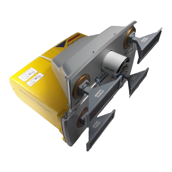
• Standard configuration (two antennas – 1 Transmitting antenna, 1 Receiving antenna) • MIMO configuration with DEM KIT (four antennas – 2 Transmitting antenna, 2 Receiving antenna) Fig. 1 – IBIS KU ETH sensor IDS GeoRadar User Guide QGG/2021/001 Rev. 1.4... - Page 13 4 - fixing point (M5) on the bottom of the box • 1 - central point that it is used to fix the centering cylinder or the hexagonal head for the tripod Fig. 2 – IBIS KU ETH rear, front and bottom view IDS GeoRadar User Guide QGG/2021/001 Rev.
- Page 14 The sensors is delivered typically with antennas mounted, otherwise connect the antennas to the waveguides using appropriate screws. Fig. 3 – Example of antennas with screw The operations of installation must follow the procedures reported in the system user manual. IDS GeoRadar User Guide QGG/2021/001 Rev. 1.4...
- Page 15 Mod: MDM/011/M4 Rev 2 3.2 How the sensor is deliverd The sensor is delivered inside a peli case. Fig. 4 – IBIS KU ETH case IDS GeoRadar User Guide QGG/2021/001 Rev. 1.4...
-
Page 16: Installation Procedure
Mod: MDM/011/M4 Rev 2 4. Installation Procedure DANGER For the sensor installation procedure follow the instructions given in the system user manual IDS GeoRadar User Guide QGG/2021/001 Rev. 1.4... -
Page 17: Switching The System On/Off
Mod: MDM/011/M4 Rev 2 5. Switching the system ON/OFF DANGER Do not power the sensor with sources other than the systems supplied by IDSGeoradar. Follow the instructions given in the system user manual IDS GeoRadar User Guide QGG/2021/001 Rev. 1.4... -
Page 18: Technical Specifications
40 cm x 28 cm x 29 cm Standard version 11 Kg Weight MIMO version 12 Kg 12 V DC – 24 V DC Input voltage range Standard 27W Power Consumption MIMO 30W Table 1 – Environmental specifications IDS GeoRadar User Guide QGG/2021/001 Rev. 1.4... - Page 19 See Table 3 Max Equivalent Isotropic EU: 26 dBm Radiated Power (EIRP) USA: 36 dBm Canada: 24.7 dBm Signal modulation FMCW Certifications CE, FCC, ISED Table 2 - IBIS KU ETH radio specifications. IDS GeoRadar User Guide QGG/2021/001 Rev. 1.4...
-
Page 20: Antenna Specifications
Antenna Type Gain [dB] Azimuth Elevation Beamwidth (-3dB) Beamwidth (-3dB) IBIS-ANT1-H38V18 IBIS-ANT2-H29V25 IBIS-ANT3-H17V15 IBIS-ANT4-H11V10 IBIS-ANT5-H12V39 IBIS-ANT6-H51V20 IBIS-ANT7-H50V31 13.5 Table 3 – IBIS KU ETH horn antennas. Fig. 5 – IBIS-ANT7-H50V31 Antenna IDS GeoRadar User Guide QGG/2021/001 Rev. 1.4... -
Page 21: Care And Transport
Mod: MDM/011/M4 Rev 2 7. Care and Transport In the present section information for IBIS KU ETH system maintenance are provided. For further details please contact IDS GeoRadar Customer Care. All maintenance operations need to be performed with the system stopped and disconnected from the power source. - Page 22 The present Disclaimer applies to all products designed, produced and distributed by IDS GeoRadar s.r.l., its Subsidiaries, Affiliated and authorized Distributors (the “Products”). IDS GeoRadar s.r.l. reserves full ownership and intellectual property rights of any “Information” contained in this Disclaimer including Trade Marks and Graphics. No part of this Disclaimer may be used or reproduced in any forms without the prior written agreement of IDS GeoRadar s.r.l.
- Page 23 For Products which shall operate by circulation in Public Areas/Roads, with or without moving traffic, Buyer/User shall verify the approval of local authority and/or site’s owner according to their specific procedures. IDS GeoRadar s.r.l. shall not be liable for any direct, indirect, special, incidental or consequential damages or injuries, including without limitation, lost revenues or lost profits, resulting by un-authorized use of the Products in Public Areas/Roads.
- Page 24 Products, either separately or in combination with other products, including but not limited to the following main aspects: a. Use of IDS GeoRadar s.r.l. Products outside its limitation of use, without proper and adequate scientific/technical knowledge or without specific training.
- Page 25 Use of the Products connected to suspected non-working equipment or with equipment (mainly PC) having characteristics not in compliance with the required specifications of IDS GeoRadar s.r.l. not expressly authorized by IDS GeoRadar s.r.l.; Poor or faulty operation of the electrical and telecommunication networks not directly managed by IDS GeoRadar s.r.l.
- Page 26 Mod: MDM/011/M4 Rev 2 IDS GeoRadar User Guide QGG/2021/001 Rev. 1.4...
- Page 27 The interpretation of data provided by the multiplicity of monitoring sensors has then the purpose of detecting movements that can be interpreted as precursors of a collapse. IDS GeoRadar User Guide QGG/2021/001 Rev. 1.4...
- Page 28 Nevertheless, (even though the radar technology employed by Monitoring Products, is deemed among the most reliable for the monitoring of instable slopes) IDS GeoRadar s.r.l. has the obligation to remind the Users that the technology used by Monitoring Products...
- Page 29 Movement of portions of terrain which are (or are close to) perpendicularly oriented with respect to the radar line of sight, could be underestimated or, even, undetected. IDS GeoRadar User Guide QGG/2021/001...
- Page 30 Monitoring Products or other equipment employed to such purpose; only operators officially trained and regularly updated by IDS GeoRadar S.r.l. (holding an “User Certificate” thereof) are allowed to use Monitoring Products. IDS GeoRadar S.r.l.
- Page 31 Monitoring Products by Users not holding an “User Certificate” issued by IDS GeoRadar S.r.l. Any Buyer or User that completely relies on information obtained from the automated data...
-
Page 32: Customer Support
For questions please, feel free to contact our Customer Support Service at the following e-mail address: GEO BU Customer Care: support.geo@idsgeoradar.com MIN BU Customer Care: support.mining@idsgeordar.com ©2020 IDS GeoRadar – Part of Hexagon www.ldsgeoradar.com IDS GeoRadar User Guide QGG/2021/001 Rev. 1.4... - Page 33 A. Appendix A In this appendix the datasheet of TX and RX antennas are reported. In particular the Elevation and Azimuth patterns are shown for ANT1-ANT2-ANT3-ANT4-ANT7 Antennas. Figure A – Elevation and Azimuth ANT1 Pattern IDS GeoRadar User Guide QGG/2021/001 Rev. 1.4...
- Page 34 Mod: MDM/011/M4 Rev 2 Figure B – Elevation and Azimuth ANT2 Pattern Figure C – Elevation and Azimuth ANT3 Pattern IDS GeoRadar User Guide QGG/2021/001 Rev. 1.4...
- Page 35 Mod: MDM/011/M4 Rev 2 Figure D – Elevation and Azimuth ANT4 Pattern Figure E – Elevation and Azimuth ANT4 Pattern IDS GeoRadar User Guide QGG/2021/001 Rev. 1.4...
- Page 36 Mod: MDM/011/M4 Rev 2 Figure F – Elevation and Azimuth ANT7 Pattern IDS GeoRadar User Guide QGG/2021/001 Rev. 1.4...
Need help?
Do you have a question about the IBIS KU ETH and is the answer not in the manual?
Questions and answers