Table of Contents
Advertisement
Quick Links
Advertisement
Table of Contents

Related Manuals for Garmin Camper 770

Summary of Contents for Garmin Camper 770
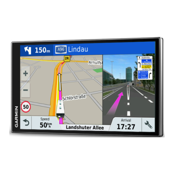
- Page 1 CAMPER 770 Owner’s Manual...
- Page 2 Android™ is a trademark of Google Inc. Apple® and Mac® are trademarks of Apple Inc, registered in the U.S. and other countries. The Bluetooth® word mark and logos are owned by the Bluetooth SIG, Inc., and any use of such word mark or logo by Garmin is under license. Foursquare® is a trademark of Foursquare Labs, Inc. in the U.S. and in other countries. HD Radio™ and the HD logo are trademarks of iBiquity Digital Corporation.
- Page 3 Finding a Location Using Coordinates ........8 Camper 770 Device Overview ............ 1 Foursquare ................. 8 Mounting and Powering the Camper 770 Device in Your Connecting to Your Foursquare Account ....... 8 Vehicle ..................1 Searching Foursquare Points of Interest ....... 8 Turning the Device On or Off ............
-
Page 4: Table Of Contents
Viewing Traffic on the Map ............15 Updating Maps and Software Using a Wi‑Fi Network ..20 Searching for Traffic Incidents ..........15 Updating Maps and Software with Garmin Express .... 21 Voice Command ............15 Device Care ................21 Setting the Wakeup Phrase ............ - Page 5 • Mount the device in your vehicle and connect it to power saving mode while charging the battery. (Mounting and Powering the Camper 770 Device in Your • To turn off the device completely, hold the power key until a Vehicle, page prompt appears on the screen, and select Off.
- Page 6 You should add a vehicle profile for each camper to be used an alert remains at the top of the screen until you leave the with your Camper 770 device. one-way street or correct your direction of travel. Select Settings > Vehicle Profile >...
- Page 7 You can start route by selecting a location from the map. NOTICE Select View Map. Garmin is not responsible for the accuracy of or the Drag and zoom the map to display the area to search. consequences of using a red light or speed camera database.
- Page 8 Select an option: • On your Camper 770 device, select Apps > Last Spot > Go!. • When the device prompts you, select Yes to search for • On your watch, start the Watch Link app, select Find My Car, nearby parking.
- Page 9 Taking a Detour You can take a detour for a specified distance along your route or detour around specific roads. This is useful if you encounter construction zones, closed roads, or poor road conditions. From the map, select > Change Route. TIP: If the Change Route tool is not in the map tools menu, you can add it (Enabling Map Tools, page...
- Page 10 Select an option: Select Settings > Navigation > Custom Avoidances. • To be asked each time before routing through a toll area, Select an avoidance. select Always Ask. Select > Disable. • To always avoid tolls, select Avoid. Deleting Custom Avoidances •...
- Page 11 • To search for an address in another city, enter the house Select a location. number, street name, city, and state. Finding RV Services • To search for a city, enter the city and state. • To search for coordinates, enter latitude and longitude NOTE: This feature is not available in all areas.
- Page 12 Parking Select Where To? > Categories > Intersections. Your Camper 770 device includes detailed parking data, which Follow the on-screen instructions to enter street information. can help you find nearby parking based on the likelihood of Select the intersection.
- Page 13 Checking in with Foursquare Removing a Shortcut Before you can check in with Foursquare, you must connect to a Select Where To? > > Remove Shortcut(s). supported phone running Smartphone Link and log in to your Select a shortcut to remove. Foursquare account.
- Page 14 Using the Map traveling. You can view upcoming points of interest, such as restaurants, fuel stations, or rest areas. When traveling on a You can use the map to navigate a route (Your Route on the highway, you can also view information and available services Map, page 3) or to view a map of your surroundings when no for upcoming exits and cities, similar to the information on...
- Page 15 ® appears on the Camper 770 screen. To get the most from your Camper 770 device, you should pair the device with your smartphone and connect to the If necessary, enter the security code on your phone within 30 Smartphone Link app.
- Page 16 Garmin Live Services (Bluetooth Feature Status Icons, page 11). Before you can use Garmin Live Services, your device must be Receiving Notifications connected to Smartphone Link (Pairing with Your Phone and Connecting to Smartphone Link, page 11).
- Page 17 Before you can connect to the Smartphone Link app, you must Placing a Call pair and connect your Camper 770 device with your phone. Dialing a Number If you did not connect to the Smartphone Link app during the Select Apps >...
-
Page 18: Setting Up Bluetooth Features For Your Smartphone With Android
Traffic Select Smart Notifications. Select the check box next to each notification to show. NOTICE Garmin is not responsible for the accuracy or timeliness of the Setting Up Bluetooth Features for Your traffic information. Smartphone with Android ™... -
Page 19: Enabling Traffic
For more information, go to garmin.com The voice command menu appears. /traffic. Voice Command Tips Viewing Traffic Subscriptions • Speak in a normal voice directed at the device. Select Settings > Traffic > Subscriptions. • Reduce background noise, such as voices, or the radio, to Adding a Subscription increase the accuracy of the voice recognition. -
Page 20: Using The Apps
LiveTrack data. tasks: Select to share the LiveTrack link using a social network, • Pair your Camper 770 device with the Smartphone Link app messaging app, or other sharing app (optional). on your smartphone (Pairing with Your Phone and Connecting to Smartphone Link, page 11). -
Page 21: Viewing The Weather Forecast
Viewing the Weather Forecast the option to route to your starting location first. For a round trip, the starting location and final destination can be the same. Before you can use this feature, your device must be receiving Select Apps > Trip Planner > New Trip. weather data. -
Page 22: Logging Service History
Before you can use this feature, you must be connected to manually. Smartphone Link, and you must have a subscription to the myMaps: Sets which installed maps the device uses. photoLive service (Subscribing to Garmin Live Services, Enabling Maps page 12). You can enable map products installed on your device. -
Page 23: Setting A Simulated Location
Faster Time: Calculates routes that are faster to drive but can babyCam Settings be longer in distance. The babyCam settings allow you to manage paired Garmin Shorter Distance: Calculates routes that are shorter in distance babyCam ™... -
Page 24: Language And Keyboard Settings
You can purchase an approved Garmin AC-DC adapter for proximity points alerts to display. suitable for home or office use from a Garmin dealer or NOTE: This feature is not available in all areas. www.garmin.com. The device may charge slowly when Select Settings >... -
Page 25: Updating Maps And Software With Garmin Express
NOTICE Start Garmin Express. Avoid chemical cleaners and solvents that can damage plastic Connect your Camper 770 device to your computer using a components. USB cable. Clean the outer casing of the device (not the touchscreen) using a cloth dampened with a mild detergent solution. -
Page 26: Avoiding Theft
• Do not keep your unit in the glove compartment. • Remain stationary for several minutes. • Register your device using the Garmin Express software (garmin.com/express). The device does not charge in my vehicle • Check the fuse in the vehicle power cable... -
Page 27: Appendix
You can purchase memory cards from an electronics supplier, or purchase pre-loaded Garmin mapping software (www.garmin.com). In addition to map and data storage, the memory card can be used to store files such as maps, images, geocaches, routes, waypoints, and custom POIs. -
Page 28: Index
Garmin Connect 11 audio, proximity points 19, 20 phone 11, 22 Garmin Express, updating software 21 automatic volume, enabling 2 watch 16 Garmin Live Services 12 avoidances 6 parking 4, 7, 8 subscribing to 12 area 6 last spot 4 geocaching 8 deleting 6... - Page 29 Smartphone Link 11–14 connecting 11, 13, 14 disabling calls 13, 14 software updating 20, 21 version 20 specifications 20 speech recognition 15 speed cameras 3 subscriptions, Garmin Live Services 12 suction cup 22 theft, avoiding 22 time settings 19 tolls, avoiding 5 tools, maps 10 traffic 11, 14, 15, 19 adding subscriptions 15 alternate route 5...
- Page 30 00800 4412 454 +47 815 69 555 +44 2380 662 915 +35 1214 447 460 +386 4 27 92 500 0861 GARMIN (427 646) +34 93 275 44 97 +27 (0)11 251 9800 + 46 7744 52020 +886 2 2642-9199 ext 2...
Need help?
Do you have a question about the Camper 770 and is the answer not in the manual?
Questions and answers