Advertisement
Quick Links
BRx6 Sensor Calibration Using SurvCE/SurvPC
OVERVIEW
The BRx6 internal sensors (tilt, accelerometer and compass) must be calibrated in order to use the
electronic bubble and tilted pole corrections in SurvCE. This document describes in detail the
process for calibrating the BRx6 internal sensors using SurvCE or SurvPC version 5.05 or higher.
The complete calibration consists of three steps: 1) Tilt Calibration, 2) Magnetic Spin and 3)
Directional Incline (magnetic declination).
Step 1 calibrates the tilt sensors used by the electronic bubble or LDL (Live Digital Level) feature
in SurvCE. If you only plan on using the leveling features like LDL (or electronic-bubble), level
tolerance checking or auto store by leveling then you only need to perform Step 1 calibration.
Steps 2 and 3 calibrate the e-compass sensors in the BRx6 and are only required if you are
planning to use SurvCE's tilted pole correction feature while taking GNSS measurements in
SurvCE's Store Points or Stake functions.
NOTE: The magnetic calibrations (Steps 2 and 3) are valid for a limited geographic area,
depending on the local magnetic field parameters. In general, the farther you go from the
calibration point (in tens of miles or kilometers, not typically feet or meters), the more the
calibration accuracy degrades. SurvCE contains a simple routine called "One Point Calibration
Check" that makes it easy to validate the accuracy of magnetic calibration at a new location. With
the BRx6 position FIXED, go to the Equip tab, select GPS Utilities, select Sensor Calibration, then
select One Point Sensor Test.
The One Point Sensor Test uses a two-step process to validate the magnetic calibrations. First,
holding the pole vertical and steady, tap Start. The utility to average several FIXED positions to
determine the current location. Second, lean the pole at an angle of not more than 30 degrees
and rotate the receiver in different directions. The utility checks both the calculated position and
elevation differences from the actual position established in point 1. As long as the position or
elevation differences are less than 0.050 m (0.17 feet) with a tilt angle of 30 degrees of less, the
magnetic calibration should be good. If the differences are greater the 0.050 m (0.17 feet) it would
be a good idea to recalibrate the receiver before doing inclined pole corrections.
Lastly, the magnetic anomalies exist throughout the earth's surface. There may be locations
where it is not impossible to use the BRx6's magnetic sensors or e-compass or to successfully
calibrate the BRx6 sensors.
PREPARATION
The following equipment is required to complete all three calibration steps. Only items 1 and 2 are
required for Step 1.
1. SurvCE or SurvPC version 5.05 or higher installed on your data collector
2. A quality, calibrated tribrach with accurate vials. A line vial is usually more accurate than a
spherical vial. For Step 1, the tribrach can be set on a solid table or tripod, for Step 2 the
tribrach should be mounted on a solid tripod.
3. Pole not less than two meters long with calibrated vial attached is required for Step 3 and
can be used for Steps 1 and 2. The tilt sensor calibration will only be as accurate as the
vials on the tribrach and pole.
4.
A connection to a base station using the BRx6 internal radio, the BRx6 internal GSM cell
modem or Data Collector Internet mode is required for step 3. It is best if
the effective baseline distance is less than
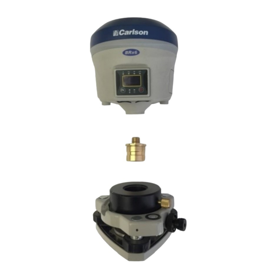
5. Mini-rotary bracket assembly that is included with the BRx6 kit.
mini-rotary bracket components are shown in this picture.
Updated: Apr 20, 2017
1 kilometer (.6 miles).
The three
Page: 1
Advertisement

Related Manuals for Carlson BRx6


Summary of Contents for Carlson BRx6
- Page 1 Step 1 calibration. Steps 2 and 3 calibrate the e-compass sensors in the BRx6 and are only required if you are planning to use SurvCE’s tilted pole correction feature while taking GNSS measurements in SurvCE’s Store Points or Stake functions.
- Page 2 RTK corrections or the presence of GNSS signals. The Brx6 can be mounted on either a tribrach or pole that has been leveled as accurately as possible. A high quality calibrated tribrach with an accurate line level in a rotating mount as shown below will provide the best calibration.
- Page 3 BRx6 Sensor Calibration The first picture below is an exploded view of the BRx6 attached to a tribrach and the second picture shows the BRx6 and tribrach mounted on a tripod prior to performing the Step 1 calibration. Once the BRx6 is horizontal and stable tap the 1. Tilt Calibration (set hz.) button. This screen will appear: Once you are sure the BRx6 receiver is level, tap the “Set Zero”...
- Page 4 (extendable) section of the pole. Attach the BRx6 to the mini-rotary bracket as shown in this exploded view. The second picture shows the BRx6/mini-rotary bracket/tribrach mounted on a tripod.
- Page 5 BRx6 Sensor Calibration Tap the 2.Magnetic Spin button to start Step 2. This screen appears: With the BRx6 level, tap the Start Vertical button and slowly start rotating the pole as shown in the image on the data collector screen.
- Page 6 Once the Vertical rotation is complete, mount the BRx6 on the mini-rotary bracket as show below. With the BRx6 still being level, tap the Start Horizontal button and again slowly rotate the pole as shown on the data collector screen below: Continue slowly rotating the BRx6 until the Horizontal rotation is complete.
- Page 7 BRx6 Sensor Calibration Tap the Update Calibration button to store the calibration values. When the calibration values have been stored this screen will be displayed. Tap the OK button and the Orange Arrow button to complete Step 2. STEP 3: MAGNETIC ANGLE BIAS OR MAGNETIC DECLINATION CALIBRATION...
- Page 8 BRx6 Sensor Calibration Making sure the pole is vertical (a bipod helps) and stationary, tap the Start Center button. If receiver is Fixed and within level tolerance, Sensor will collect and average 10 points with the progress bar advancing with each point captured.
- Page 9 During this portion of the calibration, the pole is tilted 25-35 degrees, with you standing next to the point where the pole touches the ground and with the BRx6 display always facing you and you facing the cardinal direction (East, South, West, North) being collected as shown in the four picture sequence below (camera is facing south).
- Page 10 BRx6 Sensor Calibration Here is a screen shot with the pole to the north: The Sensor Calibration display guides you during this process. If no points are being collected either the Tilt angle is incorrect (between 25 and 35 degrees) or the Target Direction (direction you are facing) is not correct.
- Page 11 Tap OK, and then tap the Orange Arrow button to complete the calibration. The BRx6 sensors are now calibrated. If multiple BRx6 batteries are used, steps 2 and 3 of the calibration process should be completed for each battery. Updated: Apr 20, 2017...
Need help?
Do you have a question about the BRx6 and is the answer not in the manual?
Questions and answers