Advertisement
Quick Links
Quick Start Guide
© 2017-2020 AeroVironment, Inc. Proprietary Information. This material includes privileged or proprietary data that shall not be disclosed to any third
party at any time, nor shall it be duplicated or used by the recipient, in whole or in part, for any purpose other than to disseminate information provided
by AeroVironment, Inc. Furthermore, this material contains trade secrets and/or commercial or financial information that is proprietary and is exempt from
disclosure under the Freedom of Information Act and protected from disclosure by the Trade Secrets Act. See 5 USC 552(b)(4); 18 USC 1905.
These items are controlled by the U.S. Government and authorized for export only to the country of ultimate destination for use by the ultimate consignee or
end-user(s), herein identified. They may not be resold, transferred, or otherwise disposed of, to any other country or to any person other than the authorized
ultimate consignee or end-user(s), either in their original form or after being incorporated into other items, without first obtaining approval from the U.S.
government or as otherwise authorized by U.S. law and regulations.
Advertisement

Subscribe to Our Youtube Channel
Summary of Contents for AV QUANTIX MAPPER
- Page 1 Quick Start Guide © 2017-2020 AeroVironment, Inc. Proprietary Information. This material includes privileged or proprietary data that shall not be disclosed to any third party at any time, nor shall it be duplicated or used by the recipient, in whole or in part, for any purpose other than to disseminate information provided by AeroVironment, Inc.
- Page 2 AeroVironment, Quantix Mapper, and Quick-Look are trademarks of AeroVironment, Inc. All other trademarks are property of their respective owners. 2017-2020 © AeroVironment, Inc. Proprietary Information. Export Controlled Information. Use or disclosure of information contained on this page is subject to the restriction on the title page of this document. 87731_10...
- Page 3 Quantix™ Mapper Overview craft! Welcome to Your Quantix™ Mapper Air As the operator of your new unmanned On-board processing instantly delivers aircraft, your primary tasks will be to define georeferenced high-resolution imagery the collection area, ensure a safe launch, on the included operating tablet upon and monitor the airspace.
- Page 4 5 minutes capturing critical information battery flight. With built-in dual 18MP quickly and accurately. With a simple cameras, Quantix Mapper simultaneously swipe of a button, Quantix Mapper captures true color and multispectral initiates a fully automated takeoff, flight imagery. and landing allowing for a completely Let’s start with what arrived in your...
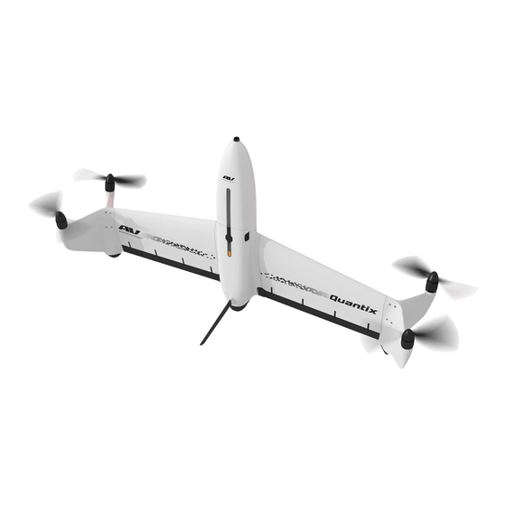
- Page 5 Overview of Components TOP OF AIRCRAFT Battery Charge Indicator Aircraft Status Bar Indicator ILS Solar Power Button Propellers Sensor Charging Jack Battery Pack Motors Landing Pad Elevons Landing Outrigger Landing Feet BOTTOM OF AIRCRAFT AIRCRAFT BATTERY AND SD CARD Airspeed Sensor Battery Pack...
- Page 6 Note: Quantix Mapper can also use user-generated custom GeoTiff image files to plan a mission. Download Map Data: Allow application to download map data for your collection area.
- Page 7 Preparing to Fly Handling the Aircraft Always carry the aircraft by the fuselage (nose of the aircraft). Never try to carry it by the wings, propellers, or elevons. Improper handling may damage the aircraft. Hold below lenses to CARRYING THE AIRCRAFT avoid touching them INSTALLING CORRECT PROPS Install the Props...
- Page 8 Open the Quantix Mapper application, login, and tap “Fly Now” for the desired collection area to start preflight check. The Quantix Mapper application will guide you through a preflight check and launch procedure, including a final confirmation swipe commanding the aircraft to launch.
- Page 9 Fly Safely Stop Lights Your Quantix Mapper will update you on the status of the wind speed and the link from its current location and altitude. Green: Conditions are good. Yellow: Conditions are less than ideal, but manageable. Red: Conditions are bad.
- Page 10 After Your Flight Taking a Quick Look Wait for the Quick-Look bar to turn blue after the aircraft lands. Tap Quick-Look to view the low resolution imagery. Note: Do not power off the aircraft until the “See Quick Look” bar appears, indicating that transfer of the low resolution Quick-Look to the tablet is complete.
-
Page 11: Troubleshooting
Watch the Mag Calibration instructional video prior to calibration. To access the video, open the Quantix Mapper application on your tablet, login, select Settings in the Menu button, and select Mag Calibration. Tap the Play button on the video at the top of the screen to start the video. - Page 12 AeroVironment, Inc. 900 Innovators Way Simi Valley, CA 93065 AeroVironment (NASDAQ: AVAV) is a technology solutions provider at the intersection of future-defining capabilities that include robotics, sensors, software analytics and connectivity. Customer Service: 888.372.2890 The company pioneered and is a leader in the markets for small Unmanned Aircraft Systems (UAS), Tactical Missile Systems (TMS), ciscustomerservice @ avinc.com High-Altitude Pseudo-Satellites (HAPS) and Commercial Information...
Need help?
Do you have a question about the QUANTIX MAPPER and is the answer not in the manual?
Questions and answers