
Summary of Contents for SkyTraxx SKYTRAXX 2.0
- Page 1 Manual Skytraxx GmbH Im Bildstöckle 5 79822 Titisee-Neustadt info@skytraxx.eu www.skytraxx.eu _________________________________________________ Page 1 Skytraxx rev 1.13 Firmware 1.50...
-
Page 2: Table Of Contents
TABLE OF CONTENTS Introduction External features Input keys, turning the unit ON and OFF Navigating the MENU First steps Main screen Map view 9,10 Manually setting the altitude 11,12 DEVICE STATUS - Menu Viewing files TRAXX - Menu USB - Menu PARAMETER - Menu 17,18 AIRSPACE - Menu... -
Page 3: Introduction
Introduction Thank you for purchasing the SKYTRAXX 2.0 and for placing your trust in us. The SKKYTRAXX 2.0 uses the most up-to-date componentry available and has been specifically designed for paragliding and hang gliding. The new technology has enabled us to produce a much more efficient unit and to offer many new features which we are certain you will appreciate. -
Page 4: External Features
External Features A Mini-USB port allows data exchange and battery charging. A reset button located near the USB port can be actuated by inserting a thin pencil or a paper clip, and gently pressing. Mini-USB Mini-USB M4 thread M4 thread Reset button Reset button On the back cover there is an internal M4 thread. -
Page 5: Input Keys, Turning The Unit On And Off
Turning the Unit ON and OFF Connect the Skytraxx to the charger supplied and fully charge the unit. To turn the unit ON press and hold the Menu key for 3 seconds and then press OK. -
Page 6: Navigating The Menu
Navigating the Menu After the turning on the device press the Menu key. DEVICE STATUS SIMULATOR TRAXX PILOT DATA USER FIELDS PARAMETER PLAY MUSIC AIRSPACE FIRMWARE UPDATE WAYPOINT FACTORY DEFAULT GOTO TASK Use the Minus/Plus keys to move the indicator up and down the list (2 pages). Press the Menu key anytime to return to the main screen. -
Page 7: First Steps
steps First 1. Setting up Pilot details: From the Main Menu select PILOT DATA. Press OK to begin editing and use the keys next to the symbols which appear on the screen to navigate. Example: Your name is Max Mustermann IGC-ID: MaMu (4 characters) Pilot:... -
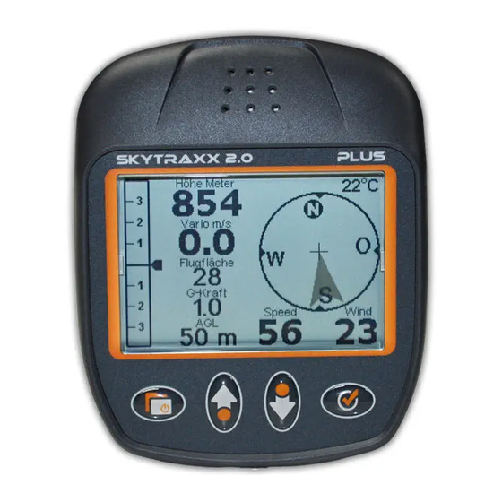
Page 8: Main Screen
Main screen Main screen 24°C Höhe Meter 1078 Vario m/s Gleitzahl Dist to Airspace 14.2 km GndSpd WindSpd Time 10:35:02 GPS Height AMSL Wind direction Digital vario Position of last Thermal User-definable field 11 Track User-definable field 12 GPS strength User-definable field Battery level Groundspeed... -
Page 9: Map View
Map screen Map screen 1740 + Tafelbühl 19.8 km + Kandel 14.2 km NW/16 + Hintereck 7.9 km 480m 7.4 km Airspace within warning distance Waypoints Airspace warning distance Groundspeed Wind Track Scale 10 GPS Height AMSL Distance to next airspace 11 Current position Track log 12 Thermal source... - Page 10 Additonally, if the thermal database is loaded, thermal points can be viewed from the second scale setting upwards. Adding thermal points After connecting the Skytraxx to a PC, use the following link to download the thermal database and then copy it into the WAYPOINTS folder: http://xc.dhv.de/xc/modules/leonardo/data/files/dhvxc-thermals.wpt...
-
Page 11: Manually Setting The Altitude
Manual Altitude Setting adjust height manually Altitude: 354m QNH: 1012.0 hPa To manually set the altitude, press one of the middle keys whilst viewing the Main Screen. Adjust the values using the middle keys. Confirm by pressing OK. For more details on height calibration see next page. _________________________________________________ Page 11... - Page 12 If a height is indicated in the ELEVATION list using an appropriate HGT file, Skytraxx then knows the height of the entire area and will also use this height information when no 3D GPS reception is available. The hgt File contains the topography data.
-
Page 13: Device Status - Menu
Device Status Device Status Mittwoch, 13. Juli 2011 N 48° 05‘ 57‘‘ GPS: 840 m E 08° 11‘ 14‘‘ Day and date GPS Height GPS Coordinates Satellites of current location _________________________________________________ Page 13... -
Page 14: Viewing Files
TRAXX file selection TRAXX file selection A:/FLIGHTS/2011/Juli/ April June Juli Use the middle keys to select a period and press OK to accept. To delete a period: • Select the period using the middle keys. • Press and hold the OK key until the delete symbol appears. -
Page 15: Traxx - Menu
Menu choice TRAXX All flight recordings are filed by year, month and day similar to a flight log. Selecting a day brings up a list of all flights logged on that day. To view the details of a particular flight: •... -
Page 16: Usb - Menu
Turn on the unit and from the Menu list select the USB option. Connect Skytraxx to a PC using the USB cable. After few seconds a window opens on the PC displaying the contents of the Skytraxx. In Windows XP it looks like this: AIRSPACES Airspace data... -
Page 17: Parameter - Menu
Menu choice PARAMETER Parameter settings can changed by scrolling to the parameter to be changed using the middle keys, selecting that parameter by pressing OK and then altering its setting using the middle keys again. Sink threshold Sink-rate at which the vario begins sounding Climb threshold Climb-rate at which the vario begins... - Page 18 Menu choice PARAMETER (contd) Expert settings (contd): Tone pitch rise Tone gain Beep pitch Tone gap sink Max. audio frequency Vario sensibility Auto silent Thermal lane Rescue alert Temperature offset Voice output Airspace audio output Bluetooth Maximal G-force GoogleEarth Karte/Map Choice between Course up and North up Altitude limit...
-
Page 19: Airspace - Menu
Menu choice AIRSPACE Show Airspace Press OK then choose from the options on the screen to display airspace in the vicinity. Press OK to toggle between activating and deactivating any airspace for displaying on the screen. Select File To load airspace data for use, files can be saved in one of two ways. First select a highlighted file by pressing OK and then following the on-screen prompts: Option1: Only the selected file will be loaded for use, over-riding any... -
Page 20: Waypoint - Menu
Menu choice WAYPOINTS New Waypoint A new waypoint at the current position can be created by pressing OK. A number is offered as the default name of the new waypoint. To label the waypoint differently, press the Minus key and enter the prefered label using the middle keys. -
Page 21: Goto - Menu, Final Leg
Menu choice GOTO Selecting GOTO presents a list of the waypoint data which has been loaded for viewing. (For how to load waypoint data see Menu choice WAYPOINTS on page 20.) When a waypoint is selected, a screen is created with all the information necessary to navigate to the chosen waypoint. - Page 22 Goto / Endflight Goto / Endflight 24°C Kandel Süd 805 m T +104 m GZ +5.1 GZT +7.2 Direction 1h 12 min. of target 14.2 km GndSpd WindSpd 10:35:02 Waypoint name Glide ratio needed to reach target Current GPS Height Time to target Height relative to target Distance to target...
-
Page 23: Task - Menu
Menu choice TASK New task Select New task with OK and give it a title using the middle keys. Create the task by pressing Menu. Once a task exists waypoints can be added to it. Edit task Any existing task can be edited. Press OK, select the task to be edited and OK again to begin the edit and select an operation from the options shown: Add waypoint to the bottom of the list. -
Page 24: Simulator - Menu
Menu choice SIMULATOR To view the range of possible announcements and functions, select the simulator mode; GPS reception is simulated. In flight the simulator must be switched off! Menu choice PILOT DATA Setting up of IGC file information is carried out by selecting this from the menu. -
Page 25: User Fields - Menu
Menu choice USER FIELDS Three user-definable fields (see pg. 8) can be set to any of the parameters in the list below. To change the parameters in these fields, select USER FIELDS from the menu by pressing OK. Select the field to be changed and then select the desired parameter from the list. -
Page 26: Play Music - Menu, Firmware Update - Menu
Menu choice PLAY MUSIC If desired, audio files can be loaded into the unit and played. The files must be entered using a special format. This function is to enable testing of the unit´s sound quality. For anyone interested in trying this out, the programme „Switch Sound File Converter“... -
Page 27: Displaying Thermal And Wind Information
Thermal and wind indication The unit indicates the position of the last encountered thermal, which is in effect, the last position with the highest rate of climb. The wind direction is indicated as soon as a change of course is flown. -
Page 28: Battery
Battery The SKYTRAXX II is powered by the latest in high-quality lithium ion batteries. The battery is not affected by the so-called memory effect common to some other types of batteries. Use only the battery charger provided or the PC connection. When the unit is charging an indicator shows on the main screen. -
Page 29: Technical Data
Technical data Power supply: Lithium-Ion accumulator 3.7 V 2600 mAh Operating time on one charge: 30 – 40 hours Memory size: 2 gigabytes (extendable) Dimensions: 120 x 98 x 27 mm Weight: 185 grams Supplied with: Delivery includes 220 V battery charger and USB cable. 24 month guarantee from date of purchase. -
Page 30: Water Landings
Water landings In case water has penetrated the device: • Turn the device off • Dry the unit (e.g. with a hair dryer) • Send the device to us at Blankform for inspection . The guarantee is invalidated through improper use e.g. landing in water or by opening the device. -
Page 31: Disposal
Disposal The end user has a legal obligation to dispose of the battery and the unit in an appropriate manner and in accordance with local by- laws. Disposal in domestic waste is prohibited! Pollutant-containing batteries and accumulators are marked with the symbol below, indicating prohibition of disposal in domestic waste. -
Page 32: Safety Information
Safety information Skytraxx Varios are used exclusively at the owner´s risk. No liability will be accepted by the manufacturer for any damage or overwriting of files which may occur through the use of the provided PC software. The manufacturer expressly assumes no liability for any possible death or injury in relation to height, position or speed configurations arising from dangerous flying situations.
Need help?
Do you have a question about the SKYTRAXX 2.0 and is the answer not in the manual?
Questions and answers