
Summary of Contents for Seattle Avionics Merlin ADS-B
- Page 1 Installation and Pilot’s Guide A Practical Guide to Your New ADS-B Receiver Version 1.1 September 26, 2017...
-
Page 2: Preface
Seattle Avionics, Inc. FlyQ EFB is a registered trademark of Seattle Avionics, Inc. Merlin ADS-B is a trademark of Seattle Avionics, Inc. ForeFlight is a trademark of ForeFlight, LLC. Seattle Avionics and ForeFlight have no business agreement or relationship and ForeFlight has not endorsed or approved using the Merlin with their products. -
Page 3: Table Of Contents
Preface ................... 2 Setup ....................4 Antennas ................... 4 Power ....................5 Other Connectors ................6 Orientation ..................7 Using the Merlin with FlyQ EFB ..........9 Connect to FlyQ EFB ................9 Traffic ....................10 ADS-B Traffic Limitations ............11 Traffic Display .................. 13 Relative Altitude and Climbing or Descending ......14 Two-Minute Line ................. 14 Threat-level Color Coding ............14 15 NM Ring ................. 15 Traffic Filter ................. 16 Weather Display ................17 ADS-B or Internet ................ 17 On the Map ................. 18 For an Airport ................20 Nearby Weather ................21 Graphical Wind Optimizer ............21 Status Indicators . -
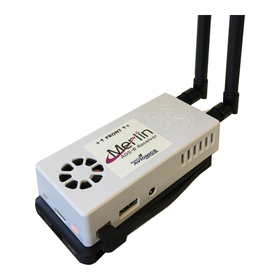
Page 4: Setup
Setup Antennas The Merlin includes two antennas, one for each of the two different ADS-B radio bands. The antennas are tuned to each frequency so are not interchangeable. The antennas are labeled with 1090 and 978, however, there is no matching designation on the box. Therefore, we have added a colored sticker to one of the antennas and one of the connectors on the box. Attach the antenna with colored dot (the color will vary) to the connector on the box with a matching dot. Attach the other antenna to the other connector. The antennas have a joint so may be angled to fit your windscreen. They may also be replaced with wired antennas to mount the device somewhere out of view of the sky. The WAAS GPS is internal and has no external antenna. You may replace it with one that has an external antenna to mount it without a sky view. See: http://a.co/j9frPgm Merlin Installation and Pilot’s Guide Page 4... -
Page 5: Power
Power The Merlin can be powered by the included battery pack or connected directly to a USB power supply (not included). The battery pack has an integrated USB connector cable on one side that plugs into the Merlin very neatly if the Merlin is stacked above the battery pack. Use the included rubber- bands to attach the battery to the Merlin. The rubber-bands also create an anti-skid surface that keeps the device from sliding around the airplane’s dash. The Merlin runs directly off the battery pack for about four hours of normal use. For extended use, connect the included USB cable from the battery pack to a USB charger while the battery pack’s integrated USB cable is connected to the Merlin. In this configuration, the battery pack will charge while it provides power to the Merlin, giving unlimited running time plus four hours of emergency backup power. Merlin Installation and Pilot’s Guide Page 5... -
Page 6: Other Connectors
We’ve included a high-quality USB micro cable for recharging the battery pack or directly connecting the Merlin to power. Connect the thin end of this cable to the device and the larger end to a standard USB power “brick” or to a USB power adapter that you have in your plane. A power brick is not included with the package. The Merlin has a built-in fan that turns on when the device’s internal temperature warrants; it does not run all the time. The fan’s speed depends on the temperature. Other Connectors The device has other connectors that are not used at this time. This includes an HDMI port (video) and an audio jack. Merlin Installation and Pilot’s Guide Page 6... -
Page 7: Orientation
Orientation The Merlin includes an AHRS (Attitude Heading Reference System) to provide yaw, pitch, and roll to FlyQ’s 3D synthetic vision. The device must be placed on the plane’s dashboard in a specific way or the axis will be wrong. Specifically, refer to the Front sticker on the device and ensure that Front is pointing straight out the front windscreen. Depending on the slope of your windscreen, you may need to tilt the antennas. Note: Gyros tend to drift even when oriented and calibrated correctly. Therefore, FlyQ EFB includes a calibrate button when in the 3D synthetic vision view. The icon looks something like a spinning top. To calibrate, fly straight and level then tap that icon. Also note that FlyQ EFB’s 3D view only displays ground terrain properly when actually flying or using the built-in simulator; if you’re sitting at a desk, the ground may not appear. Note: It is possible to mount the device in a different orientation. If you do, you’ll need to use the Stratux web interface (described in the Customizing the Stratux Software Merlin Installation and Pilot’s Guide Page 7... - Page 8 section at the end of this document) to reconfigure the gyros for proper yaw, pitch, and roll. Note: The Merlin’s AHRS works with FlyQ EFB but it may not work with other EFB applications, most notably ForeFlight™. Experimental Stratux builds may work but we make no claims about such experimental builds and do not suggest using them in conjunction with FlyQ EFB. See the Optimizing the Merlin for ForeFlight section towards the end of this document. Merlin Installation and Pilot’s Guide Page 8...
-
Page 9: Using The Merlin With Flyq Efb
Using the Merlin with FlyQ EFB Connect to FlyQ EFB The Merlin is a Wi-Fi based ADS-B system that can connect to multiple iPads simultaneously. To connect it to FlyQ EFB or almost any other iPad app: 1. Supply power to the device via the USB cord and ship’s power or a battery pack. There is no on/off switch; it’s on when supplied power. 2. Open the Settings app on your iPad and tap the Wi-Fi choice. 3. Select the network that begins with merlin or stratux. Note: The iPad may show a small (i) symbol with the words Security Recommendation next to the connection. This is not an error or a problem; it’s the iPad simply telling you that the merlin or stratux Wi-Fi connects only to the device, not to the Internet. 4. Start FlyQ EFB. 5. Within a few seconds after the app starts, you should see ADS-B Connected at the top of the app. 6. A bit later, you should also see the colored Status indicators at the top right of the app light up. Specifically, the ADS-B light (3 from the left) should turn green and, if the device has a view to the sky, the GPS light (1 from the left) should also turn green. 7. If you turn the Merlin off, the green ADS-B status light should turn red within about 30 seconds. Merlin Installation and Pilot’s Guide Page 9... -
Page 10: Traffic
Traffic Important! ADS-B traffic is a map layer in FlyQ EFB, like any other map layer such as Radar, METARs, Obstacles, etc. By default, Traffic is not on. Therefore, you won’t see any traffic until you click the Layers button (stack of papers icon) on the map and select Traffic. Merlin Installation and Pilot’s Guide Page 10... -
Page 11: Ads-B Traffic Limitations
ADS-B Traffic Limitations Although the FAA created ADS-B to help them with traffic management, the way FAA ground stations broadcast traffic is highly problematic and pilots must be aware of the very significant limitations. Specifically: 1. If your plane is not ADS-B Out equipped (that is, has a transmitter as well as a portable receiver), you will only get 978 ground-based traffic if another plane nearby has an ADS-B transmitter. Moreover, the traffic you see is traffic near him, not you. "Near" is defined as a hockey-puck shaped region centered on the transmitting plane with a radius of 15 NM and height of +/- 3500 ft. Thus, there may well be traffic near you that you never see on the ADS-B feed. 2. If you see no traffic on your iPad, it means either there really is no traffic or there may be traffic but no one in the area that is ADS-B Out (transmitter) equipped. Worse, you cannot tell the difference! 3. A "dual channel" ADS-B receiver, like this one, provides substantially better traffic information because it also Merlin Installation and Pilot’s Guide Page 11... - Page 12 receives traffic broadcast air-to-air from airliners passing overhead. 4. To get the best possible traffic information, equip your plane with ADS-B Out transmitter or a new 2020- compliant transponder in addition to the portable ADS-B receiver. Merlin Installation and Pilot’s Guide Page 12...
-
Page 13: Traffic Display
Traffic Display Important! ADS-B traffic is a map layer in FlyQ EFB, like any other map layer such as Radar, METARs, Obstacles, etc. By default, Traffic is not on. Therefore, you won’t see any traffic until you click the Layers button (stack of papers icon) on the map and select Traffic. Merlin Installation and Pilot’s Guide Page 13... -
Page 14: Relative Altitude And Climbing Or Descending
Subject to the limitations noted above, FlyQ EFB shows traffic sent by ADS-B receivers using many features to help keep you safe: Relative Altitude and Climbing or Descending In addition to icons, a text box above the icon tells you the altitude of the target relative to you. A plus (+) means the target is above you; a minus (-) means it's below you. The number shown is the altitude differential in hundreds of feet. Thus, a target marked as +30 is 3,000 ft. above you. After the number, there may be an arrow at the top or the bottom of the text box. This indicates if the target is climbing (up arrow) or descending (down arrow). Note: The relative altitude may be a little off because FlyQ compares your GPS altitude to the pressure altitude encoded in the ADS-B feed. Two-Minute Line For targets that are moving, FlyQ shows a line that indicates where the target will be in two minutes at its current speed and direction. Thus, longer lines indicate faster aircraft. Threat-level Color Coding Similar to many other places in the app, FlyQ uses three colors to indicate threat-level: A white target with a light gray background is generally no factor. A white plane with an orange background is within 5 NM and +/- 3000 ft. of you so should be considered a potential threat. A white plane with a red background and a red text box means imminent danger with a threat within 1 NM and +/- 1,000 ft. Merlin Installation and Pilot’s Guide Page 14... -
Page 15: 15 Nm Ring
Tip: Due to the way ADS-B works, you may see a shadow of your plane as a red-level threat, especially if your plane is not ADS-B Out equipped (because your plane is being sent as a target for someone else). If you do have ADS-B Out, you can tell FlyQ EFB to hide your plane by entering its tail number in the Ignore tail number field in Settings. This has no effect unless your aircraft has ADS-B Out because only an ADS-B Out system transmits your tail number to ground stations. 15 NM Ring Turning on the Traffic layer also turns on a 15 NM ring centered on your position to help you judge distance. Merlin Installation and Pilot’s Guide Page 15... -
Page 16: Traffic Filter
Traffic Filter In high-traffic areas, you may see so many targets, often very far above you, that it's difficult to visually pick-out the ones you really care about. Thus, we provided a filter system that removes any traffic that is no-factor. This is defined the same way the FAA determines nearby traffic: When On, FlyQ only shows traffic within a 15 NM radius of your position, +/- 3,500 ft. You can toggle this filter on and off by tapping the gray text box on the 15 NM ring that says 15 NM, Traffic Filter: On/Off. Traffic Filter Off Traffic Filter On All ADS-B traffic Only traffic within a 15 NM radius, +/- 3,500 ft. Note: Even when the traffic filter is off, FlyQ EFB hides traffic more than 75 NM away to reduce screen clutter and improve system performance and memory utilization. Merlin Installation and Pilot’s Guide Page 16... -
Page 17: Weather Display
Weather Display Weather is crucial to flying and FlyQ EFB has a wealth of weather information that make flying easier and safer. ADS-B or Internet While on the ground, FlyQ uses weather downloaded from the Internet and stores this on the iPad for use while flying. When using an ADS-B receiver and you’re within range of an ADS-B ground station (which often also means being at least 3,000 ft. AGL), FlyQ EFB gets as much weather as possible from the ADS-B receiver. ADS-B weather is limited to just radar, METARs, TAFs, and Winds Aloft. For other weather layers, most notably Satellite and AIRMET/SIGMETs, FlyQ uses the data last loaded from the Internet. Note: The Merlin is a dual-channel ADS-B receiver. The 1090 band receives traffic only, no weather. Weather and traffic are both broadcast on the 978 band sent from ground stations. Therefore, if you’re flying too far from a ground station (or below 3,000 ft. AGL), you may see traffic from 1090 but no weather as you’re not receiving any 978 transmissions. Weather can be accessed in a number of ways: Merlin Installation and Pilot’s Guide Page 17... -
Page 18: On The Map
On the Map FlyQ EFB can display any combination of Nexrad, Satellite, METAR/TAF, AIRMETs/SIGMETs, and Winds Aloft over any 2D map. Tap the Layers button then select as many or as few weather layers as you like. When the METAR/TAF layer is on, single-tap over a METAR/TAF circle and FlyQ pops up a box with the nearest METAR and TAF information. Tap the More button for Merlin Installation and Pilot’s Guide Page 18... - Page 19 additional weather information including Winds Aloft for that airport. The Winds Aloft arrows point in the direction that the wind is moving not in the direction from which it comes. The number at the end is the expected winds aloft speed, in Kts, at your current GPS altitude. Thus, this number generally changes as you climb. Tap the large Weather tab at the bottom of the screen to see winds at other altitudes. If you’re not flying, the Winds Aloft layer assumes the winds at your default cruise altitude. This is 7,000 ft. unless you change it. The METAR/TAF circles use three colors to depict the actual or expected weather conditions: green is VFR, yellow is MVFR, and red is IFR, LIFR, or VLIFR. The colors are determined by either METARs or TAFs, depending on the time. If the airport has a METAR report that is still valid (they last one hour), the Merlin Installation and Pilot’s Guide Page 19...
-
Page 20: For An Airport
color is based on a METAR. If you're outside the time range of METARs, FlyQ EFB automatically switches to using TAFs. Note: A single-tap on the map shows METAR/TAF info if that layer is on unless the TFR layer is also on and there is a TFR in that area. This is because the single-tap is used to show either TFR info or METAR/TAF info. For safety reasons, when a TFR overlaps a METAR/TAF circle, we choose to show TFR information. For an Airport When an airport is selected, switch from the default General sub tab to the Weather sub tab. You'll see animated local, regional, and national radar images around the airport if you're connected to the Internet. This is not available when offline or using ADS-B. You'll also see the METAR and TAF from the nearest airport (not necessarily that airport if it doesn't have these weather reports), a Winds Aloft table, and even a Leidos (Lockheed Martin) or DUATS briefing. If connected to the Internet, the top area shows the current temperature and, with a tap, an easy-to-read 7-day forecast. Merlin Installation and Pilot’s Guide Page 20... -
Page 21: Nearby Weather
Tip: Tap the METAR or TAF to see it much larger. This is especially handy in-flight or for those of us who aren't 25 anymore. Nearby Weather Tap the large Weather tab at the bottom of the screen to see essentially the same information as described above for your current GPS location. Graphical Wind Optimizer Tap the Weather tab at the bottom of the screen then select the Winds sub tab. This is a unique and very helpful feature as it answers the age-old inflight question of whether to fly Merlin Installation and Pilot’s Guide Page 21... - Page 22 higher or lower. The Graphical Wind Optimizer shows what the winds are like relative to your current track (the aircraft image with the wind arrow through it) and what kind of headwind or tailwind to expect, given your current course, at different altitudes. In the graph below, the various headwind (red) and tailwind (green) components in knots are shown for every altitude from 0 to 16,000 ft. Altitudes in the table have the 000's place removed for brevity. Thus, flying at 16 (16,000 ft.) would produce a 1 kt headwind while flying at 2,000 ft. will produce a 5 kts tailwind. Similarly, the representation of an aircraft with an arrow means a 21 kts wind that is almost a perfect crosswind at the current altitude. The current altitude is shown both on the gauge below the map (11,500) and as the light gray bar on the graph. Merlin Installation and Pilot’s Guide Page 22...
-
Page 23: Status Indicators
Status Indicators The upper right area of the screen shows critical device and data status and aging information. These four indicators use colors to tell you at a glance the status of your GPS, the age of the weather you’re viewing, the status of a connected ADS-B system, and the battery status of the connected ADS-B system (if applicable). GPS is on the left, then Weather (Wx), then ADS-B, then ADS-B battery. As elsewhere in FlyQ EFB, green means good, yellow means marginal, and red means there is a problem. Tap anywhere on the Status Indicator to see additional information about GPS, Weather, or ADS-B. It does not matter which specific indicator you tap. Once the detailed page appears (as below), tap the large GPS, Weather, or ADS- B cells on the left side of pop-up for more details about each system. Note: These indicators are designed to quickly alert you to problems so we’re careful to only use red when there is an actual problem. Specifically, the lack of an ADS-B receiver does not turn the ADS-B indicator red unless one was recently connected then disconnected. Otherwise, everyone without an ADS-B would always see a red indicator in the corner which defeats the point of alerting to you a problem as it would always give the impression of a problem. In cases where no ADS-B has been connected, the ADS-B icon remains clear. Similarly, if an ADS-B system is connected but it has no built-in battery (like the Merlin and most certified ADS-B systems) the ADS-B battery indicator is either green or clear, not red. Merlin Installation and Pilot’s Guide Page 23... -
Page 24: Gps
GPS iPads have been known to lose the GPS lock in flight. At a glance, this area gives you a quick indication of whether or not the GPS is engaged and working as expected. Green means the GPS is working properly and providing data with a high degree of accuracy. Yellow indicates that a GPS is connected but the accuracy is marginal. Red means a GPS is either not connected or has not provided a position update in the last 60 seconds. Blue is used when you’re using the GPS simulator. Purple (rarely seen) means you’re using an ADS-B receiver but the GPS feed is coming from a different source such as the iPad’s internal GPS or a separate GPS. This is also where you engage the built-in GPS simulator. Note: Source will show as iPad when using an external Bluetooth GPS because the GPS is working at the operating Merlin Installation and Pilot’s Guide Page 24... -
Page 25: Weather
system level rather than with a direct connection to FlyQ EFB. The GPS tells the operating system the location and the OS provides that location to FlyQ EFB without specifying if the source was an external GPS or the iPad’s internal GPS. This does not apply to ADS-B sources because FlyQ EFB directly connects to them. Weather Weather information is critical when flying and you need to know the age and source of the weather to make decisions. This display immediately shows the age and source of each weather product. Weather is downloaded from the Internet every 2 minutes and cached on the iPad for use during flight if you’re not using an ADS-B receiver. Note: An ADS-B system does not receive all the same data as FlyQ EFB gets from the Internet. Specifically, Satellite is not available in the ADS-B data feed. AIRMET/SIGMET data is in the ADS-B feed but, as of this writing, FlyQ EFB does not process it. This means that the sample display above shows everything working as designed. Merlin Installation and Pilot’s Guide Page 25... -
Page 26: Ads-B
ADS-B FlyQ EFB displays a wealth of information about connected ADS-B systems. This includes the time of the last update for GPS, weather, and traffic, the number of ground stations, the relative position of received ground stations, type of system connected, and software version. Note: The lack of an ADS-B receiver does not turn the ADS-B indicator red. Rather, the ADS-B indicator only turns red if an ADS-B system is connected then disconnects. In cases where no ADS-B has been connected, the ADS-B icon remains clear. Merlin Installation and Pilot’s Guide Page 26... - Page 27 Similarly, if an ADS-B system is connected but it has no built-in battery (like the Merlin – even one that is actually connected to a battery pack) the ADS-B battery indicator is clear or green rather than red. Optimizing the Merlin for ForeFlight™ Merlin runs the Stratux software which supplies weather, traffic, and GPS position to ForeFlight as of this writing. The Stratux folks have an experimental build that is supposed to work with ForeFlight's AHRS. We can make no claim about this and that version of the Stratux software does not work with FlyQ EFB or any other iPad / Android app so we do not recommend using it. Instead, we suggest using FlyQ EFB for a 30-day free trial. It's easier to use, takes far fewer taps to get information, uses larger text and buttons, is higher rated, and less expensive. No harm in trying it. https://seattleavionics.com/FlyQ If you require the AHRS to work properly with ForeFlight, at the expense of using any other app, here is the URL to the experimental Stratux builds that support it. Again, we do not recommend using experimental builds, especially as they will keep the unit from working with any device beyond ForeFlight. http://updates.stratux.me/builds/dangerzone Once downloaded to your PC or Mac (do not use an iPad), connect your PC or Mac to the built-in Stratux web interface as described in the Customizing the Stratux Software section below. Merlin Installation and Pilot’s Guide Page 27...
-
Page 28: Customizing The Stratux Software
Customizing the Stratux Software Your new Merlin uses open-source Stratux software created by Chris Young and maintained with the help of many talented volunteer developers. You can learn more about Stratux by visiting http://stratux.me You can also go to that web site to look for updated versions of the Stratux software or to view questions and answers about the system that other people have asked. The software that powers your device is highly customizable. For example, if you want to orient the device differently to better mount in your plane, you can reassign the three position gyros to different orientations. We’ve pre-configured the software for general use but it is possible to customize it further. It’s also possible to look at a wealth of detailed information that comes from the ADS-B data stream. FlyQ EFB takes this raw data and presents as much as possible using graphics, colors, and so on but you can see raw data if you like or if you’re trying to diagnose problems. To customize the Stratux software: 1. Power the Merlin device 2. Connect an iPad, a PC, or a Mac to use the Wi-Fi network that begins with merlin or stratux. Ignore any “info” or security warnings as the iPad is just telling you that this Wi-Fi network does not connect to the Internet. 3. Point your web browser to: 192.168.10.1 4. You should see a web page with categories on the left side and details about the selected category on the right. For example: Merlin Installation and Pilot’s Guide Page 28... - Page 29 The Status category (above) shows details about data received from the radios. If you don’t see this screen, check that your device is connected to the stratux or merlin Wi-Fi. We’ve had some reports of issues connecting with a Windows PC so we recommend using your iPad if you have any trouble with a PC. Merlin Installation and Pilot’s Guide Page 29...
-
Page 30: Maintenance
The GPS/AHRS category (above) shows details about the GPS such as position, number of satellites, etc. as well as a way to test and calibrate the AHRS. The Settings category lets you turn various features on or off, install new versions of the Stratux software (once you download it to your PC or Mac), reboot the system, and re- align the AHRS should you wish to position the device differently. Maintenance The unit should require no maintenance in normal use. However, should the antenna connectors become loose, you will need to open the box and tighten them. We have provided a special small screwdriver to remove the six small screws and two wrenches to tighten the antennas (one to hold the inside nut, one to turn the outside nut at the same time). You’ll need to use the wrenches to ensure that you don’t inadvertently twist internal wires. Merlin Installation and Pilot’s Guide Page 30... - Page 32 Seattle Avionics, Inc. 19825 141st Place NE, 2nd Floor Woodinville, WA 98072 info@seattleavionics.com +1.425.806.0249...
Need help?
Do you have a question about the Merlin ADS-B and is the answer not in the manual?
Questions and answers