Table of Contents
Advertisement
Quick Links
Advertisement
Table of Contents

Related Manuals for Hi-Target Qstar Series

Summary of Contents for Hi-Target Qstar Series
- Page 1 Qstar series high precision mobile GIS product specification instruction...
- Page 2 Handbook revision situation introduction Revision date Revision times Qstar series high precision 2012.8 mobile product introduction V1.0...
- Page 3 Use of the introduction Welcome to use Qstar series high precision mobile GIS product introduction, this manual applies to Q star series, this manual introduced how to set and use Qstar series high precision mobile GIS product. Specification of the introduction...
-
Page 4: Related Information
You can find the instructions through the following methods: 1 Purchased products from the Hi-Target will with a CD, open the CD and you can find the instruction; 2 Land the official website of the Hi-Target, through "downloaded zone"—" product specifications "—"... -
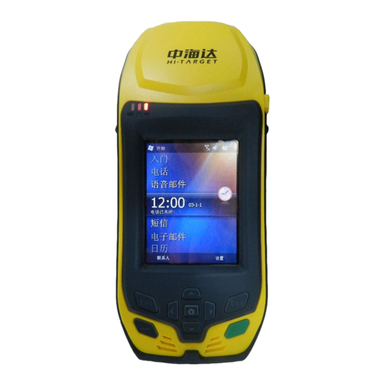
Page 5: Products Overview
At the same time, the configuration of the large capacity of lithium battery can meet the requirements of all day work. Qstar series high precision mobile GIS products are integrated designed, and it is equipped with functions such as GPS, embedded Windows Mobile 6.5 system, digital camera, microphone, 3 G communications, bluetooth communication, large storage, USB port, SD card expansion ,etc. - Page 6 In order to improve the stability of the Qstar series high precision mobile GIS products and use cycle, please avoid Qstar series high precision mobile GIS products exposed to extreme environments , such as: damp, high temperature, low temperature, corrosive gas or liquid, etc.
- Page 7 C H A P T E R The introduction of Qstar series high precision mobile GIS products The introduction of this chapter: ■the front of Qstar series high precision mobile GIS products ■the back of Qstar series high precision mobile GIS products ■Interface ■ touching pen ■battery...
- Page 8 The microphone: built-in microphone can be used for the acquisition of voice messages. The back of Qstar series high precision mobile GIS products The back of Qstar series high precision mobile GIS products , including the camera, battery, the belt hole, horn, etc.
- Page 9 Interface Qstar series high precision mobile GIS products interface position is identified, its main function is charging and data transmission, installing SIM card and SD card, etc. Picture2-3 ◇...
- Page 10 Data cable Picture2-6 ◇Qstar series high precision mobile GIS products interface: used in connection of USB with Qstar series high precision mobile GIS products. ◇USB interface: to connect computer USB port , used for data download.
- Page 11 Belt Because Qstar series high precision mobile GIS product is big, in order to prevent sliding in the process of working, it is equipped with antiskid belt, please entangle belt when you work . Picture2-7...
-
Page 12: Basic Operation
▇data obtain ▇Application functions Most of the Hi-Target Qstar series high precision mobile GIS products setting and operation can be completed by touching pen , the common operation can be completed by the keyboard . Now we will introduce the appearance and function of the keyboard simply. -
Page 13: Microsd Card
Navigation button: move the cursor, to choice the options content. Notice: when is not in work Qstar series high precision mobile GIS product temporarily, please close a backlight to save electricity, to extend industrial GIS data collector work time. 3G card 3 G card can support data communication current, it can equipped with voice mobile phone model optional. - Page 14 The concrete use method and requirements:charging with standard configuration is demanded when charging the Qstar series high precision mobile GIS product,charge in 10 ℃ ~ 40 ℃ temperature range. Using for the first time in general, there should be some battery power, you should use up the inside electricity before charging again, the first three charging must achieve12 hours, after that charging 6 hours.
- Page 15 Figure 3-9 shutdown ◊ On state, long press 3 seconds, it will tip you to confirm shutdown, click on the "shut down". Figure3-10 Network connection Click "start" - > "DialConnect", if you have set up dial-up parameters, click "dial-up connection",you can direct dialing.
-
Page 16: Application Functions
First,switch on , enter the Windows system, Qstar series high precision mobile GIS product it is no need to open applications. Connect the USB port which with a smaller cable line with the , connect the other end USB plug with your PC. - Page 17 Technology parameters Technology parameters This chapter will introduce you related parameters of Qstar series high precision mobile GIS , the product function will vary according to the different models. When you refer to this product chapter, please refer to corresponding technical parameters according to the equipment you purchase.
- Page 18 phone voice calls function 5 million pixel camera with LED the fill light √ √ √ √ √ Integrated microphone and speakers √ √ √ √ √ The built-in RFID writing and reading modules √ The built-in bar code scanner √...
Need help?
Do you have a question about the Qstar Series and is the answer not in the manual?
Questions and answers