
Subscribe to Our Youtube Channel
Summary of Contents for Columbus V - 990 Mark II
-
Page 1: User Manual
V 990 Mark II Multifunction GPS Data Logger User Manual Voice Point Of -tag Tagging Interest sensor Unique Auto Over- -165 speed ON/OFF Alarm Sensitivity Mode Long Duration © 2016 Victor y Co., Ltd... - Page 2 Thank you for choosing our product. Before using it, make sure you have read this User's Manual and understood how to correctly use and maintain it. This will start your pleasant GPS positioning experience! CAUTION! This Manual is intended to guide you through the safe and correct use of the product and its accessories, avoiding improper operations that may result in injury of yourself or any other person or cause device damage.
-
Page 3: Table Of Contents
Contents Packing List Relevant Software Time Album Parts Description How to install Part Names Configuring settings Functions of button Managing tracks LEDs and audible alerts Adding voice and photos Function Description Setting track points Exporting a track Accessories Configuring the device Track conversion options About GPS Google Earth... -
Page 4: Packing List
Packing List Please make sure that your package includes the following items. V-990 Multifunction GPS Data Logger Main Unit Car Charger (Input: 12V) Charging Cable (Support Auto ON/OFF Function 2 meters) Protective Case Carrying Strap USB MicroSD Reader User Manual Software CD Warranty Card... -
Page 5: Parts Description
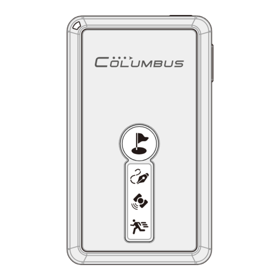
Parts Description Part Names Part Names Power/Function button Microphone Voice Record Button Power Connector Main Status LED GPS Active Antenna (Built-in) Li-polymer Battery (Built-in) Point of Interest Button Log LED GPS Status LED Motion Detecting LED MicroSD Card Slot Hand Strap Hole... -
Page 6: Functions Of Button
Parts Description Functions of Button Functions of Button Power/Function Button Long press the key to turn on or off the power supply. Short press it to change among the two modes: Motion Detecting Mode and Normal Mode. Refer to P.16 for detailed operations. Point of Interest Button Short press the button to mark the current position as a POI (Point of interest). -
Page 7: Leds And Audible Alerts
Parts Description LEDs and Audible Alerts LEDs and Audible Alerts There are 3 graphic LEDs on V-990 front face. A status LED is located at the top left. A mini speaker is integrated in the unit. These provide vivid audible and visual indications. Motion Detecting LED Log LED GPS LED... -
Page 8: Function Description
Function Description (1/2) Motion Detecting Mode sensor This device is built-in motion sensor, when the device stops moving or loses the satellite signal more than 5 minutes, the device enters standby mode automatically. In standby mode, when detecting motion, the device automatically wakes up and continues to track. - Page 9 Function Description (2/2) Positioning Photos Tagging You may use the device when you take photos using a digital camera, digital single lens reflect camera, video camera, or a camera phone (collectively referred to as the "camera" hereinafter). If the deivce operates in the positioning state, it will log the GPS records along your journey in real time.
-
Page 10: Accessories
Accessories Car Charger The car charger can work with the 12V car cigarette lighter socket. It can be only used for the device. Using it for any other purpose can damage the car charger and other devices. The car charger can work with the charging cable to automatically start up and shut down the device and charge it. -
Page 11: About Gps
About GPS The Global Positioning System (GPS) is a satellite-based navigation system made up of a network of 24 satellites placed into orbit by the U.S. Department of Defense. GPS was originally intended for military applications, but in the 1980s, the government made the system available for civilian use. -
Page 12: Getting Started
Getting Started How to Charge the Battery How to Charge the Battery This device is built in with a 1000mAh Li-polymer battery, which allows for hundreds of charge-discharge cycles. Proper charging and discharging can effectively maximize the service life of the battery. ●... -
Page 13: Place And Carry Your Receiver
Getting Started Place and Carry Your Recevcer Place and Carry Your Receiver This device is built in with a MTK 66-channels, -165dBm highly sensitive super single chipset. It can easily fix positions at most places in your car. If you bring it with you, you also can use it to fix positions in relatively unfavorable outdoor environments. -
Page 14: Memory Card Selection & File Format
Getting Started Preparing for Use Preparing for Use Memory card selection and file format This device supports MicroSD cards of most brands. The supported storage capacity is 64M to 4G. If you need to use the audio recording function, only high-speed memory cards with the capacity of more than 512M are supported because the access speeds of small-capacity cards are limited. -
Page 15: Setting Camera Date And Time
Getting Started Preparing for Use Setting camera date and time If the internal clock of your digital camera is incorrectly set, there can be error between the captured photos and track positions. Please adjust the camera time by following the correct procedure below. ●... -
Page 16: Introduction And Operating Modes
Getting Started Start to Use Start to Use Introduction and changeover of operating modes V-990 has two normal operating modes. You may switch between these modes using the Power/Function button as follows: Long press the Long press the Power Off for 3 seconds, a long for 3 seconds, two short beep and shuts down. -
Page 17: Acquiring Position
Getting Started Start to Use Acquiring position (1) Long press the “power button” for 3s to turn on the device. (2) In a relatively open outdoor environment, point the device reception antenna to the sky. Wait for several minutes until the position is fixed. (The “GPS LED”... -
Page 18: Logging Your Journey
Logging Your Journey Logging a Track Logging a Track Before running the track logging, you should correctly format your memory card. Refer to P.15 for the operation. After the device is turned on and already in the positioning state, it automatically logs the current track point once per second. -
Page 19: Adding A Voice Mark Point
Logging Your Journey Adding a Point of Interset Voice Point Of Adding a -tag Interest Point of Interest Adding a voice mark point You can add a voice mark to your traveling track at any time*. This is the simplest and most interesting way to take notes along your journey. -
Page 20: Adding A Poi Manually
Logging Your Journey Adding a Point of Interset Adding a POI manually Starting a new track You can highlight the current place of interest You can terminate the track you are logging anytime and anywhere. After that a and start a new track on your memory card. symbol is generated on the map to facilitate your recollection in the future. -
Page 21: Motion Detecting Mode
Motion Detecting Mode Logging Your Journey Integrating Photos with a Map Over-speed Alarm Motion Detecting Mode sensor V-990 will remember the last working mode. The motion detecting LED turns on in this mode. When the device is stationary, the led is on. When the device is in motion, the led is flashing. When the device stops moving or loses the satellite signal more than 5 minutes, the device enters standby mode automatically. -
Page 22: Spy Tracking Mode
Logging Your Journey Spy Tacking Mode Unique Spy Tracking Mode Mode The device is uniquely designed with the Super-long Dormant Tracking Mode (Sky Tracking Mode). In this mode, the device intermittently runs, realizing super long battery duration of up to 30 days. In this operating mode, the device is waked up, started, fixes the position, and logs the track information at a certain time interval*. -
Page 23: Vehicular Auto On/Off
Logging Your Journey Vehicular Auto ON/OFF Auto Vehicular ON/OFF Auto ON/OFF When you use the device in your car, please charge it using the car changer and the charging cable. Auto ON/OFF and standard charging can be realized, that is, the device is turned on as soon as the vehicle is started and the power supply to the car cigarette lighter socket is connected, and turned off as soon as the vehicle is shut down and the power supply is disconnected. -
Page 24: Relevant Software
Relevant Software Time Album Time Album How to install The device comes with a CD-ROM that presents the "TIME ALBUM" software. The software is specially designed for the device. You may use it to add photos, voice, and other information to a track, which can be viewed and played back on map software. -
Page 25: Configuring Settings
Relevant Software Time Album Configuring settings Always configure the following settings when you launch and use “TIME ALBUM” for the first time. (1) You need to correct the GPS time, which is the GMT (2) Set the vehicle you will take: Car Mode or Fly Mode. If time. -
Page 26: Adding Voice And Photos
Relevant Software Time Album Adding voice and photos (1) Copy tracks, audio records, photos, and other files from your memory card to the hard disk. (2) Click the "Add photos and voice" button. Select the location of the audio records and photos. The software automatically looks for and matches the audio records and photos applicable to the current track and adds them to the track. -
Page 27: Configuring The Device
Relevant Software Time Album Configuring the device (1) Click the "Device Setting" button. An interface is launched. Click "Generate” to generate a Config.TXT file. With the help of the USB reader, copy the file to the root directory of your memory card. (2) The “Device Setting”... -
Page 28: Google Earth
Relevant Software Google Earth Google Earth How to install Click the Google Earth® icon and complete the installation. Playing back a track Double click the track file (with an extension of KMZ) generated by "TIME ALBUM" to play back the track of your journey in Google Earth®. -
Page 29: Details On Track Points
Relevant Software Google Earth Details on track points This device can record the following types of track point in Google Earth®: (1) Start point. The data point of (2) End point. The data point of (3) Way point. It is the most the first second on each the last second on each track. -
Page 30: Troubleshooting
Troubleshooting (1/3) Signal Reception Symptoms Page Causes and Remedy Battery level is low. Charge the receiver. No satellite signal received ● Avoid using the receiver under an automobile windshield that contains metallic wires or has been coated with a film, or in a house, tunnel, or underground parking Intermittent lot, or on a patio-like land, or near high-voltage cables, or in any other environment where strong shield or interference presents. -
Page 31: Track Logging
Troubleshooting (2/3) Track Logging Symptoms Page Causes and Remedy ● The device has not acquired the position yet. Its logging function cannot be Track logging normal until the position is acquired. cannot be ● The logging function has been disabled. Short press the Power/Function button initiated to activate the logging function. -
Page 32: Power
Troubleshooting (3/3) Symptoms Causes and Remedy Page ● The voice content cannot be heard clearly in noisy outdoor environments. When The voice content is too noisy or cannot be you record the audio, stay as near the microphone as possible. heard clearly ●... -
Page 33: Specification
Specification (1/2) ■ Product Specification: Altitude Limit: 18,000 meters (60,000 feet) max Velocity Limit: 515 meters/sec (1,000 knots) max Dimension: 43(L)x74(W)x9.9(H)mm Acceleration Limit: 4G max Weight: 55g Jerk Limit: 20 m/sec Volume: 32cc Minimal Data Resolution: 1/10000 minute Chipset: MTK 3339 Super chip (Latitude, Longitude);... - Page 34 Specification (2/2) ■ Storage Card: ■ Operation: Type: MicroSD / T-Flash Operation Temperature: -10ºC to + 50ºC Capacity: 64M, 128M, 256M, 512M, 1G, 2G, 4G Store Temperature: -20ºC to + 60ºC (Voice recording requires capacity above 512M) Operation Humidity: 5% to 95% (No condensing) Format: FAT (FAT16) files system *1 The test environment shall be a place in open sky.
-
Page 35: Formatting Microsd
Formatting the MicroSD Card How to format the 4G MicroSD card to FAT. Illustrated with the Windows® 7. ① Open "Control Panel" , select "Administrative ② Select "Disk Management". Tools" – "Computer management". ③ Select the location of the MicroSDcard, right click ④... -
Page 36: Timealbum Pro
TimeAlbum Pro "TimeAlbum Pro" is Co-developed by Columbus and RouteConverter, a famous GPS software in Germany. Features: • Over 14 map patterns to view the tracks: Google Maps, Google Satellite, OSM Map, OSM Contour Map, etc. • Supports over 20 GPS track file formats, as well as formats converting of most common GPS data logger in market. - Page 37 Memo...
- Page 38 Memo...
- Page 39 Memo ©2016 VICTORY. All rights Copyright reserved. Reproduction, transfer, distribution or storage of part or all of the contents in this document in any form without the prior written permission of VICTORY is prohibited. Under no circumstances shall VICTORY be responsible for any loss of data or income or any special, incidental, consequential or indirect damages howsoever caused.
- Page 40 Please visit http://cbgps.com/v990 for more information. The newest software at http://cbgps.com/software The user manual is made of English Ver 2.1 100% recyclable paper pulp. PRINTED IN CHINA...
Need help?
Do you have a question about the V - 990 Mark II and is the answer not in the manual?
Questions and answers