Table of Contents
Advertisement
Advertisement
Table of Contents

Related Manuals for Magellan GPS Pioneer


Summary of Contents for Magellan GPS Pioneer
- Page 1 GPS Pioneer User Manual...
- Page 2 WARNINGS A measure of knowledge by the user is required for proper and safe use of the Magellan GPS Pioneer™. READ THE USER GUIDE & WARRANTY COMPLETELY. Use Good Judgment This product is an excellent navigation aid, but it does not replace the need for careful orientation and good judgment.
-
Page 3: Table Of Contents
TABLE OF CONTENTS Introduction ............ 1 Welcome to the Magellan GPS Pioneer ........ 1 GPS Pioneer Description ............. 1 Magellan GPS Pioneer ............2 Getting Started ..........3 Installing the Batteries ............3 Getting Signals from Satellites ..........3 Initializing the Receiver - EZStart ........4 Computing a Position ............ - Page 4 Working with Routes........17 Creating a Route ..............17 Viewing a Route ..............19 Activating/Deactivating a Route ........20 Deleting a Route ..............21 Appending a Leg to a Route ..........21 Activating a Leg in a Route ..........22 Editing a Leg in a Route ............
-
Page 5: Introduction
Basic Operation. Before you begin, make sure that your package includes the items listed on the GPS Pioneer box. If any items are missing or damaged, contact your Magellan dealer or retailer. GPS Pioneer Description The GPS Pioneer is a self-contained hand-held GPS receiver designed for general purpose position locating and navigation. -
Page 6: Magellan Gps Pioneer
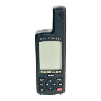
Magellan GPS Pioneer GPS Antenna The ENTER key confirms data The GOTO key is entries or menu used to create a selections. direct route to any landmark stored in memory. The NAV key accesses the The MENU key is Position and... -
Page 7: Getting Started
Getting Started Installing the Batteries The GPS Pioneer uses two AA alkaline batteries that are installed at the back of the receiver. To remove the battery cover, turn the ring of the battery door screw counterclockwise until the battery cover can be removed. -
Page 8: Initializing The Receiver - Ezstart
You do not need to initialize your receiver each time you use it. Follow these steps to initialize the GPS Pioneer if this is the first time you are using it. -
Page 9: Computing A Position
Computing a Position The GPS Pioneer will begin to acquire information from the satellites and use this information to compute your current position (called a position fix). Whether you have just... - Page 10 GPS Pioneer on, the GPS Pioneer will display the following screens in the order shown. As the GPS Pioneer searches for satellites, some of the small circles around the large circle will become black...
-
Page 11: Basic Operation
Basic Operation Saving a Position Fix Position fixes can be saved in memory for use later when you want to return to that position. Saved position fixes are referred to as landmarks or LMK. To save (mark) your current position press MARK Receiver-Generated Name: The GPS Pioneer prompts you to enter a name or... -
Page 12: Creating A Landmark
To create a landmark press MARK The GPS Pioneer prompts you to enter a name or accept the receiver- generated name for this landmark. When the desired name is displayed at the top of the screen press... -
Page 13: Viewing The Position Screen
Viewing the POSITION Screen The POSITION screen displays the coordinates for your last computed position and information about any satellites that are visible. It can be accessed by pressing the key. Latitude and Longitude North Indicator Satellite Satellite Elevation Pointer Degrees above the horizon of the satellite Number of... -
Page 14: Viewing The Navigation Screens
Viewing the Navigation Screens Without an Active Route. Without an active route the navigation screen displays your heading and the speed at which you are traveling. The lower portion of the screen displays a moving compass. The triangle at the top of the compass points in the direction you are traveling and the arrow points to north. - Page 15 With an Active Route. When you have an active route the navigation screen still displays your heading and speed but also includes the bearing and distance to your destination. The moving compass is then replaced with steering informa- tion. You can use the graphical representation or the steering indicator to assist in directing you towards your final destina- tion.
- Page 16 A second navigational screen is also provided while you have an active route. This screen is very similar to the first screen except that the distance to the destination has been replaced with XTE (cross track error, the distance left or right that you are off course) and heading has been replaced with TTG (time to go).
-
Page 17: Creating A Goto Route
Creating a GOTO Route The simplest form of a route is a one-leg route called a GOTO route (you are GOing TO a destination). This is routing you from your current position to a landmark stored in memory All that is required to create a GOTO route is that you have saved a landmark indicating the location of your destination. -
Page 18: Summary
GOTO key to set a GOTO route and highlight the landmark you created before and press ENTER. Your GPS Pioneer is ready to navigate you back to where you started. The navigation screens are now showing you the distance and bearing back to the original landmark. As you... -
Page 19: Working With Landmarks
Working with Landmarks Viewing a Landmark To view a stored landmark press MENU until LMKS appears at the top of the screen. Press . The BEARING/DIS- ENTER TANCE screen for the first landmark in the receiver’s memory is displayed with the bearing and distance from the last computed position fix to that landmark. -
Page 20: Editing The Landmark Name
ARROWs to confirm (YES or NO) and press ENTER If the landmark is used in a route or is the destination landmark in a GOTO route, the GPS Pioneer alerts you that the landmark cannot be deleted. Remove the landmark from the route and repeat. -
Page 21: Working With Routes
The route depicted here is a three-leg route. Leg 1 extends from landmark A to landmark B, leg 2 from landmark B to landmark C, and leg 3 from C to D. The GPS Pioneer gives you information on the NAV screens that directs you to the destination of each leg sequentially. - Page 22 The receiver prompts you for a starting landmark for the route. The first landmark, *POS, is your present position. Use the ARROW pad to scroll through the list of landmarks. When the desired landmark is displayed (and flashing) press ENTER The display changes to allow the selection of the landmark to be used as the end of the first leg in the route.
-
Page 23: Viewing A Route
GPS Pioneer that this was the last leg in ENTER the route and you are finished creating a route. Continue this process for each leg in the route remembering... -
Page 24: Activating/Deactivating A Route
The first screen displayed is the ROUTE SUMMARY screen. This screen displays the start and end landmark for the entire route as well as the total distance of the route. Use the LEFT/RIGHT ARROWs to view the legs in the route. The leg screen displays the FROM and TO landmark for the leg as well as the distance and bearing for the leg. -
Page 25: Deleting A Route
Deleting a Route With a route in memory, press until ROUTE appears MENU at the top of the display. Press . While still viewing ENTER the Route Summary screen, press the UP ARROW three times until the display indicates PRESS ENT TO DELETE. Press . -
Page 26: Activating A Leg In A Route
Activating a Leg in a Route As you are navigating you may decide that you no longer wish to continue on the leg that you are now using. Instead you wish to use another leg of the route. You will need to activate the leg of the route with the desired destination (TO land- mark). -
Page 27: Editing A Leg In A Route
Use the LEFT/RIGHT ARROWs to select a new FROM landmark and press ENTER The TO landmark begins flashing alerting you that the GPS Pioneer is ready for you to select a new TO landmark. Press to accept the TO landmark as it is ENTER... -
Page 28: Deleting A Leg From A Route
ARROW until PRESS ENT TO DELETE is displayed and press ENTER The GPS Pioneer prompts you to confirm the deletion of the leg. Use the LEFT/RIGHT ARROW to select (flashing) YES to delete or NO to cancel. If you attempt to delete a leg that causes the route to contain a leg that is under the 0.1 mile leg distance... -
Page 29: Additional Features
Additional Features Viewing the Time and Date You can view the current time and date (obtained from the satellites) by repeatedly pressing the key until TIME MENU is displayed at the top of the screen. Viewing Elevation You can view the last computed elevation for your GPS Pioneer by repeatedly pressing the key until MENU... -
Page 30: Changing Coordinate Systems
(DEGMINSEC) or Universal Transverse Mercator (UTM). The choice you make will depend upon the maps or charts you may be using. You want your GPS Pioneer to be displaying the coordinates in the same mode that your map or chart uses. -
Page 31: Changing Map Datums
Changing Map Datums If you are using a map (or chart) in conjunction with your GPS Pioneer you need to insure that the datum used by the GPS Pioneer matches the one used in creating the map. The map datum can usually be found in the legend box of the map or chart. -
Page 32: Changing Time Display And Time
GPS Pioneer. Changing North Reference The GPS Pioneer uses magnetic north as a default reference for all navigation computations. You can change this to true north (good if you are also using a map) or back to magnetic north (default, good to use if you are using a compass) under the SETUP menu. -
Page 33: Initializing The Receiver (Ezstart)
Initializing the Receiver (EZSTART) If you desire to re-initialize the receiver, (for example, you have moved more than 300 miles since the last time the receiver was turned on) you can do so in the SETUP menu. Press until SETUP is displayed at the top of the screen MENU and press . -
Page 34: Activating The Demo Mode
Activating the Demo Mode To turn on the Demo Mode, press until SETUP is MENU displayed at the top of the screen and press . Use the ENTER RIGHT ARROW until SETUP DEMO is displayed. To toggle between ON or OFF, press . -
Page 35: Troubleshooting
Troubleshooting Does not turn on: 1. Check to insure that the batteries are installed correctly and that the battery terminals are clean. 2. Replace the batteries. Takes more than 10 minutes to get a position fix: 1. If there are large obstacles nearby or overhead, move to a new location with a clear view of the sky and turn the receiver back on. -
Page 36: Commonly Asked Questions
Destination Pointer does not point to the destination: 1. Note that much of the navigation information is based upon your movement. If you are standing still the navigation information (destination pointer, etc.) is not updated until you are moving. (The receiver is unable to detect which way you are facing while you are stationary.) Position coordinates on your receiver do not match the... - Page 37 Can I use NiCad Batteries in my GPS Pioneer? Yes. However, the battery life of your GPS Pioneer will be diminished with the use of NiCad batteries. Can I attach my GPS Pioneer to external power? Yes.
-
Page 38: Icons
The Magellan GPS Pioneer will retain its memory (route, landmarks, last fixes, etc.) for 20 minutes with the batteries removed. Memory will be retained even with low batteries for approximately one month if the unit is turned off. -
Page 39: Contacting Magellan
Monday through Friday, from 7 a.m. to 5 p.m., Pacific Standard Time. Faxes can be sent to 909-394-7070. If necessary, you can also return your unit to Magellan for repair. (Please call for assistance first.) Ship the unit to... -
Page 40: Accessories
Carrying Case: Protects your GPS Pioneer from the elements and allows you to carry your GPS Pioneer on your belt, keeping it handy for when you need it. Mounting Bracket: Mounts on a dashboard or other surface allowing you hands-free operation of your GPS Pioneer. -
Page 41: Glossary
(If the unit has been moved while turned off and has not yet acquired a new position fix, the start of the GOTO will be the position fix last recorded.) Heading The compass direction in which the Magellan GPS Pioneer is moving. - Page 42 0 to 180 . Magnetic North The direction toward the north magnetic pole from the observer’s position. Position Fix Position coordinates as computed by the Magellan GPS Pioneer.
- Page 43 Time To Go (TTG) is the measurement of how long it will take you to arrive at your destination. TTG is based on how fast you are moving towards the destination and the distance remaining. True North The direction to the geographical North Pole from an observer’s position.
-
Page 45: Index
Index Antenna 2; reception 3; Function keys 2 troubleshooting 31 GOTO creating a route 13-14; Batteries installing 3; life 25; deactivate 14 NiCad 33; warning 34 Bearing/Distance 11; for a landmark 15 Icons 34; see light Initializing 4-5; 29 Coordinate Systems changing 26 Landmark (LMK) creating 8;... - Page 46 Navigation screen Moving Sat status 5 compass (without active Satellite signals 3 route) 10; Steering (with active route) 11, 12 Time and Date view 25; North Reference changing 28 changing 28; daylight savings On/Off 4; deactivation 14; Time To Go (TTG) 12, 39 troubleshooting 31 Tracking 6, 34 Troubleshooting 31...
- Page 47 No. of Landmarks: 100 stored landmarks No. of Routes: Legs per route: 10 maximum Power: Source: 2 AA alkaline batteries or 3.3 VDC ( 2%) 100 mA at receiver or 9-16 VDC with Magellan External Power Cable Battery Life: Approximately 24 hours continuous operation...
- Page 48 This product has been certified by Mission HOME™, the official educational campaign of the U.S. space community. 960 Overland Court, San Dimas, CA 91773 22-60125-000...