Garmin GPS V Reference Manual
Garmin owner's manual personal navigator gps v
Hide thumbs
Also See for GPS V:
- Specifications (2 pages) ,
- Specification (2 pages) ,
- Owner's manual and reference manual (89 pages)
Table of Contents
Advertisement
Advertisement
Table of Contents

Related Manuals for Garmin GPS V


Summary of Contents for Garmin GPS V
- Page 1 ® GPS V personal navigator ® owner’s manual reference guide...
- Page 2 Except as expressly provided herein, no part of this manual may be reproduced, copied, transmitted, disseminated, downloaded or stored in any storage medium, for any purpose without the express prior written consent of Garmin. Garmin hereby grants permission to download a single copy of this manual and of any revision to this manual onto a hard drive or other electronic stor-...
-
Page 3: Introduction
GPS V. After you have read the Quick Start Guide, you may wish to read through this owner’ s manual for more details on the GPS V’ s operating features. As you become more familiar with your GPS V, use this manual as a reference—starting with the index to fi... - Page 4 WARNING: For use in vehicles, it is the sole responsibility of the owner/operator of the GPS V to place and secure the GPS unit so that it will not interfere with the vehicle operating controls and safety devices, obstruct the driver’ s view of driving con- ditions, or cause damage or personal injury in the event of an accident.
-
Page 5: Map Data
Map Data One of the goals of Garmin is to provide customers with the most complete and accurate cartography that is available to us at a reasonable cost. We use a combination of governmental and private data sources, which we identify as required in product literature and copyright messages displayed to the consumer. -
Page 6: Software License Agreement
Software License Agreement Software License Agreement BY USING THE GPS V, YOU AGREE TO BE BOUND BY THE TERMS AND CONDITIONS OF THE FOLLOWING SOFTWARE LICENSE AGREEMENT. PLEASE READ THIS AGREEMENT CAREFULLY. Garmin Corporation (“Garmin”) grants you a limited license to use the software embedded in this device (the “Software”) in binary executable form in the normal... -
Page 7: Fcc Compliance
FCC Compliance The GPS V complies with Part 15 of the FCC interference limits for Class B digital devices FOR HOME OR OFFICE USE. These limits are designed to provide reason- able protection against harmful interference in a residential installation, and are more stringent than “outdoor”... -
Page 8: Limited Warranty
This Garmin product is warranted to be free from defects in materials or workmanship for one year from the date of purchase. Within this period, Garmin will, at its sole option, repair or replace any components that fail in normal use. Such repairs or replacement will be made at no charge to the customer for parts or labor, provided that the customer shall be responsible for any transportation costs. -
Page 9: Table Of Contents
Battery Installation ......4 Turning the GPS V On/Off ..... . 5 Adjusting Screen Contrast and Backlighting . -
Page 10: Table Of Contents
Introduction Table of Contents Marking Your Location as a Waypoint ... . . 48 Main Menu ........50 Tracks . -
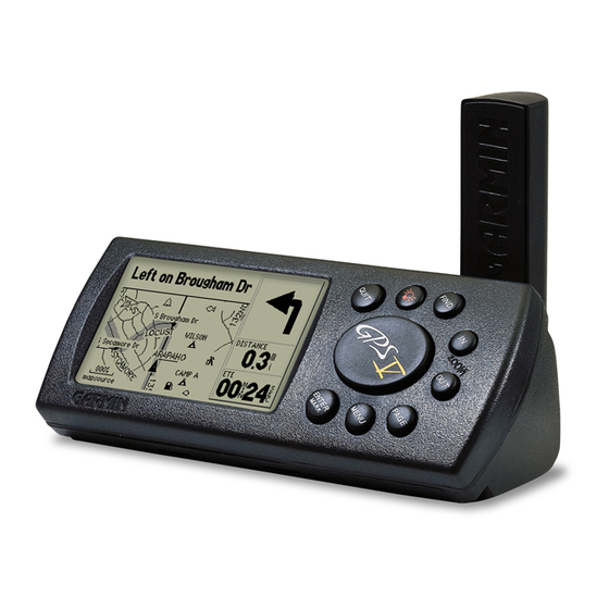
Page 11: Reference
Reference GPS V Description Unit Description Antenna Rotate upright for best satellite reception Rocker Keypad Keypad with Backlighting Landscape Orientation See page 2 for Key descriptions Power/Backlight LCD Display 4-gray level LCD with Backlighting Left Side / Bottom Insert AA Batteries... -
Page 12: Keypad Usage
Turns the unit on and off. A momentary press while the power is on displays the backlight/contrast adjustment window. Press and hold to turn the GPS V off. Switches between the main pages and returns the display from an option PAGE –... -
Page 13: Features/Data Entry
Features/Data Entry The following features and procedures are referred to throughout this manual. CURSOR – A highlighted area on the screen which can be moved up/down/left/ right with the ROCKER KEYPAD to select individual fi elds on the display. Moving the cursor to a given location allows you to begin data entry or scroll through a list. -
Page 14: Battery Installation
NiCad, NiMH or Lithium batteries as well. Alkaline batteries will last up to 25 hours in your GPS V. NiCad batteries will typically provide shorter battery life and Lithium batteries will provide longer battery life, particularly in colder conditions. -
Page 15: Turning The Gps V On/Off
Turning the GPS V On (and Off) Before turning the GPS V on, fi nd a suitable location for its use. If you are operat- ing the GPS V indoors, with the “Use Indoors” option, location is not critical. However, during actual navigation use the GPS V should be outside—or on the dashboard of... -
Page 16: Adjusting Screen Contrast And Backlighting
Reference Screen Contrast and Backlighting Backlight (lamp) icon on Main Menu as it appears when backlighting is off. Backlight (lamp) icon on Main Menu as it appears when backlighting is on. Adjusting Screen Contrast and Backlighting If lighting conditions make it diffi cult to see the display screen, you can adjust the contrast or turn on the backlight. -
Page 17: Unit Pages At A Glance
Unit Pages at a Glance All of the information needed to operate the GPS V is found on “pages” (i.e., display screens). If no destination is selected, there are three main pages: Satellite Status, Map, and Trip Information. Press the PAGE key to sequence through the pages in forward order, or use the QUIT key to sequence through the pages in reverse order. -
Page 18: Satellite Status Page
Satellite Location and number The Satellite Status Page appears when the GPS V is fi rst turned on (after the welcome screens and warning pages). This page is part of the main page sequence and may be displayed at any time by pressing PAGE (repeatedly) until it appears. The Satellite Status Page includes “sky view”... -
Page 19: Receiver Status
Receiver Status is indicated at the top of the Satellite Status Page, directly above the sky view. The status will be shown as one of the following conditions: Searching for Satellites—the GPS V is looking for any available satellites in view. Locating Satellites—the GPS V is initializing and collecting new almanac data. -
Page 20: Satellite Status Page Options
Satellite Status Page Options Many features of the GPS V are menu driven. Each of the main pages has an options menu, allowing you to custom tailor the corresponding page to your prefer- ences and/or select special features which specifi cally relate to that page. - Page 21 New Location—allows you to designate your approximate position in order to speed up satellite acquisition. This option is useful if you have relocated 500 or more miles since the last time you used the GPS V, and ensures that the unit is looking for the proper satellites.
-
Page 22: The Map Page
The GPS V features a real-time moving map to illustrate your current position and your intended route. The Map Page is one of the main operating pages of the GPS V and you’ll likely use it more than any other page. It graphically shows the area around your current location, and marks your route to a destination with a bold dark gray route line. -
Page 23: Zooming, Panning And Pointing
Zooming, Panning and Pointing There are three main actions you can perform on the Map Page: zooming, panning and pointing. The map display has map scales from 20 feet to 800 miles. The current map scale is indicated on the bottom left corner of the map display. To change the map scale: 1. - Page 24 4. To go to the location on the map, select ‘Goto’ on the information page for that item and press ENTER. The Route Preference window appears. Select ‘Faster Time’, ‘Shorter Distance’, or ‘Off Road’, and press ENTER. The GPS V will route you to the selected destination using turn-by-turn navigation.
-
Page 25: Navigation Information
Once you are fi nished with panning, you can quickly remove the panning arrow and re-center the map on your present position by pressing the QUIT key. Map Page Navigation Information The following navigation information is displayed on the Map Page: When not navigating (no destination selected) •... -
Page 26: Map Page Options
Map Page. Map Page Options Many features of the GPS V are menu driven. Like each of the main pages, the Map Page has an options menu, allowing you to customize the page to your preferences and/or select special features which specifi... -
Page 27: Map Page
Setup Map—allows you to confi gure the map display to your preferences, includ- ing map detail, map orientation, automatic zooming, and color mode. The map setup options are organized under a series of “fi le tabs”, making individual selections easier to locate and change. - Page 28 Reference Map Page ‘Lock On Road’ causes the triangular present location symbol to “snap to” the nearest road. This compensates for any minor errors in your location reading. The ‘Direct Goto Line’ can represent bearing to your destination (and remain tied to your present position) or a course line (which remains fi...
- Page 29 Change Fields—allows you to choose the data displayed on user-selectable data fi elds adjacent to the map display (to the right of the map when horizontally oriented) or to remove the data fi elds and display a full-screen map. To change a data fi eld or change the number of on-screen data fi elds: 1.
- Page 30 Use the ‘MapSource Info’ screen to enable or disable any map data you have downloaded to your GPS V. Maps are enabled when the box adjacent to the map name is checked. Measure Distance—allows you to measure the bearing and distance between any two points you choose on the Map Page.
-
Page 31: Trip Information Page
• Be certain to reset the Trip Information before beginning the trip. Instructions on resetting will follow. • If you make frequent stops, leave the GPS V powered on and receiving satellites. This will allow the unit to accurately measure elapsed time during the trip. How- ever, some vehicles disconnect power to the cigarette lighter when the ignition is turned off. - Page 32 Trip Information was last reset. Stopped Time—The length of time that the vehicle has been stopped (stationary) while the GPS V was still powered on and tracking your location (and since the Trip Information was last reset).
-
Page 33: Trip Information Page Options
Trip Information Page Options Many features of the GPS V are menu driven. Like each of the main pages, the Trip Information Page has an options menu, allowing you to customize the page to your preferences and/or select special features which specifi cally relate to the Trip Informa- tion Page. - Page 34 Averaging reduces the effects of position errors and results in a more accurate position reading. To use the averaging function, the GPS V must be turned on, locked onto satellites and have a valid position reading.
- Page 35 To average position samples and save the result as a waypoint: 1. With the Map Page Options displayed, use the ROCKER KEYPAD to highlight ‘Average Location’ and press ENTER. An Average Location window appears. Observe the ‘Accuracy’ and ‘Measurement Count’ fi gures. 2.
-
Page 36: Using The Find Menu
You can search for Waypoints, Cities or interstate highway Exits that are included in the GPS V basemap using the Find Menu. In addition, if you have downloaded the City Select map data, you can search for and fi nd Points of Interest, Addresses, or Intersections. -
Page 37: Using Find
5. Use the ROCKER KEYPAD and ENTER to spell the name of the desired waypoint, city or point of interest on the top line of the page (pressing ENTER after each letter/number is selected). 6. As you enter each letter/number, the list below is continuously updated to display any matches in the data. -
Page 38: Finding A Nearby Waypoint
Use FIND to search for nearby waypoints, cities or points of interest. If you press FIND while panning on the map, the GPS V will search for waypoints, cities or points of interest nearest to the panning pointer (see page 14). -
Page 39: Finding An Exit
When viewing waypoints the information window displays the waypoint name, a map symbol, the location in latitude/longitude and elevation. City information includes city name, the size by population and the distance/direction from your current location. Points of interest information includes name, address and phone number. Finding Highway Exits You can use the Find Menu ‘Exits’... - Page 40 Reference Using Find To view exit information for another nearby interstate highway, use the ‘Select Exit Road’ option. For numbered highways, enter the number only—not the prefi x. Use the ROCKER KEYPAD to select an exit road number using the on-screen keyboard. To fi...
-
Page 41: Finding An Address Or Intersection
Finding an Address or an Intersection You must download MapSource City Select data to your GPS V to search for addresses or intersections, otherwise these options are not selectable. To locate an address: 1. Press the FIND key to display the Find Menu. -
Page 42: Recently Found Places
Reference Using Find ‘Recently Found Places’ can be used as a shortcut to retrieve locations you use often. You can quickly access this page by pressing and holding the FIND key. Use the ROCKER KEYPAD to display the desired ‘Recently Found Places’ category: points of interest, addresses and intersections, cities, or other. -
Page 43: Goto Or Routes
Using Goto or Routes The GPS V gives you several options to select a destination: FIND—Use the FIND key as described on pages 26-32. Once you have selected the desired location, use the on-screen ‘Goto’ button that appears on the information page for the desired location to navigate to that location. -
Page 44: Automatic Routes
Goto and Routes You can create automatic or manual routes. Automatic routes use the routing features in MapSource City Select data and the GPS V’s built-in basemap to automatically select the required turns to reach your fi nal destination. Manual routes are created by adding each location along the route manually, beginning with your departure point. -
Page 45: Navigating Routes
When using FIND or automatic routes, you can save the automatically-created Goto or route from the Current Route Page. This allows you to retrieve the route again for later use. When viewing saved routes, note that a hiker symbol is used to denote manual and off-road routes. -
Page 46: Deleting Routes
Reference Goto and Routes Route List Options: Follow Roads Delete Rename Delete All Copy With the route list displayed, press MENU to display the route list options. To delete a route, highlight the route on the route list, then select ‘Delete’ from the route list options. - Page 47 4. Press MENU to display an options menu. 5. To delete all routes, use the ROCKER KEYPAD to select ‘Delete All’ and press ENTER. 6. To delete the highlighted route (step 3), use the ROCKER KEYPAD to select ‘Delete’ and press ENTER. From the list of saved routes, highlight any saved manual route (denoted by hiker symbol) on the list and press ENTER to display an information page for the selected route.
- Page 48 Reference Goto and Routes Available data types for the ‘Change Fields’ option are listed on a pop-up window. Use the ‘Restore Defaults’ option to restore the original factory settings. 5. Press MENU to display an options menu. 6. Use the ROCKER KEYPAD to select ‘Reverse Route’ or ‘Copy Route’ and press ENTER.
-
Page 49: Editing Routes
Any saved manual routes can also be edited from the Route Information Page. You can insert, remove, move or change waypoints in the route. To edit a route: 1. Press the MENU key twice to view the Main Menu. 2. Use the ROCKER KEYPAD to highlight ‘Routes’ and press ENTER. A list of all routes stored in memory is displayed. -
Page 50: Current Route Page
Reference Current Route Page Subject Finder: Stop Navigation... page 41 Recalculate Route ... page 42 Use Detour... page 42 The Current Route Page only appears in the main page sequence when a destination is selected using an automatic route. The Next Turn Page can be displayed at any time from the Current Route Page by pressing ENTER. -
Page 51: Current Route Page Options
2. Press ENTER or QUIT to exit the Next Turn Page. Current Route Page Options Many features of the GPS V are menu driven. Like each of the main pages, the Current Route Page has an options menu, allowing you to customize the page to your preferences and/or select special features which specifi... - Page 52 Current Route Page When road construction or traffi c delays become a problem, select ‘Use Detour’ and the GPS V will calculate an alternate route around the problem area. Select ‘Save Route’ if you wish to keep the route for future use.
- Page 53 Show Arrival Times (or Show Times to Go)—Switches the Current Route Page between display of arrival times at each turn and the fi nal destination, or showing time to go (in hours/minutes or minutes/seconds, as appropriate). To change the time displayed on the Current Route Page: 1.
-
Page 54: Next Turn Page
Reference Next Turn Page Subject Finder: Current Route Page ... page 40 Off Road Routing Preference...pages 7, 34 The Next Turn Page is only available while nav- igating a Goto or route. However, when selecting a destination, the ‘Off Road’ route preference will display the Direction Finder Page—not the Current Route or Next Turn Pages. -
Page 55: Direction Finder Page
Direction Finder Page Pointer (Bearing to Destination) Graphic Compass Whenever a destination has been selected using the ‘Off Road’ routing preference or when navigating a manual route, the Direction Finder Page appears in the main page sequence—in place of the Current Route Page. The Direction Finder Page will guide you to your destination with a graphic compass-like display and a bearing pointer. -
Page 56: Direction Finder Page Options
Direction Finder Page Options Many features of the GPS V are menu driven. Like each of the main pages, the Direc- tion Finder Page has an options menu, allowing you to customize the page to your prefer- ences and/or select special features which specifi... - Page 57 Big Numbers (or Small Numbers)—allows you to select a different Direction Finder Page layout, with a smaller graphic compass and two user-selectable, large-char- acter data fi elds. If ‘Big Numbers’ is selected, ‘Small Numbers’ will appear as an option instead. To change the Direction Finder Page layout: 1.
-
Page 58: Marking Your Location As A Waypoint
1. Press and hold ENTER. The ‘Mark Waypoint’ page appears, with a default three digit name for the new waypoint at the top portion of the page. The GPS V captures the location from the instant at which you pressed ENTER, so you do not need to be concerned about moving, losing satellite reception or any delay while you change the name or waypoint symbol. - Page 59 Goto—Tells the unit that you want to navigate to that waypoint. Map—Shows the waypoint on the Map Page. When marking your current location, the GPS V also allows you to average position samples over time to produce a more accurate position.
-
Page 60: Main Menu
ENTER to select a Main Menu item. Main Menu The Main Menu provides you with a directory of GPS V’ s features and unit settings. From the Main Menu you can mark new waypoints, fi nd points of interest or cities, creates routes, save track logs, change unit settings, display a calendar, play games, and much more. -
Page 61: Tracks
With the track log feature turned on, track logs are automatically recorded as soon as the GPS V is turned on and has determined its position. To be certain that the ‘Trac- Back’ feature will return you to the desired point, you should clear the track log before your begin traveling. - Page 62 Reference Main Menu: Tracks From the Saved Tracks Page, press MENU to select ‘Setup Track Log’ and modify the track log recording settings. Track logs can be recorded by time, distance or ‘Auto’ intervals. ‘Auto’ uses a resolution function where additional track points are not saved until you deviate left/right from a projected course.
- Page 63 To save the track log currently being recorded: 1. Follow the steps on page 50 to select ‘Tracks’ and display the Saved Tracks Page. 2. Use the ROCKER KEYPAD to highlight ‘Save’ and press ENTER. To display additional information for a saved track: 1.
-
Page 64: Setup
fi le tab. Main Menu: Setup The Setup Pages allow you to customize your GPS V to your personal preferences. Each selectable Setup Page is denoted by a “fi le tab” at the top that identifi es the func- tion of that page. - Page 65 GPS V and is best suited for indoor use (e.g., learning to use the GPS V or creating manual routes). The GPS V cannot be used for navigation guidance when operating in Demo Mode. The Battery setting is used to designate the type of batteries currently being use to power your GPS V: Alkaline or Lithium.
-
Page 66: Time Setup
3. Use the ROCKER KEYPAD to highlight ‘Restore Defaults’ and press ENTER. When downloading City Select data to your GPS V, you may be asked to supply a “unit ID”. This information is provided under a ‘Software Version’ selection. As... -
Page 67: Guidance Setup
The Guidance Setup Page controls how the GPS V responds when you depart from a route, how the Next Turn Page is displayed, and whether or not the GPS V shuts off automatically upon arrival at your destination. The Off-Route Recalcuation setting... - Page 68 There is a trade-off between the length of time is takes to fi nd a route and the quality of that route (i.e., how close will the GPS V’ s route be to the ideal route). The following options are available: Quickest Calculation—This provides the fastest results, minimizing the time you...
-
Page 69: Units Setup
The ‘Avoid’ selections at the bottom of the Routing Setup Page let you avoid certain items that may be undesirable in your route. However, the GPS V may still use these items if the alternatives will take you too far out of your way. -
Page 70: Timers Setup
Reference Main Menu: Setup Count Down and Count Up timers are avail- able from the Timers Setup Page. Use the Location Setup Page to change the location format. Several latitude/longitude and grid formats are available, as well as regional grids. To restore Units Setup Page features to the original factory settings: 1. -
Page 71: Alarms Setup
GPS V conform to position readings on a printed map/chart. Check the legend on your paper map/chart to determine which map datum was used to create it. Note that, format and map datum settings are best used by individuals with a work- ing knowledge of these subjects. - Page 72 Proximity waypoints allow you to mark locations you wish to avoid. Language options allow user friendly display. The GPS V has a variety of interface settings for connection to other equipment. 2. Use the ROCKER KEYPAD to highlight ‘Anchor Drag’ and press ENTER. A pop-up window will appear.
-
Page 73: Languages
MapSource data with a PC. GARMIN DGPS—The proprietary format used with a Garmin differential beacon receiver (e.g., GBR 23). Provides for tuning of the beacon receiver directly from the GPS V. NMEA Out—Supports output of standard NMEA 0183 version 3.0 data. No input. -
Page 74: Accessories
‘Beacon’ and press ENTER. Use the ROCKER KEYPAD to select ‘Scan’ or ‘Manual’ and press ENTER. If ‘Scan’ is selected, the GPS V will automatically direct the beacon receiver to scan for available beacon transmitters. If ‘Manual’ is selected, select the ‘Freq’... -
Page 75: Sun & Moon
The Sun and Moon Accessories Page graphically depicts the position of the sun and moon relative to Earth. Sun and moon positions can be displayed for any date and for any location on Earth. The Sun and Moon Accessories Page also displays sunrise, sunset, moonrise and moonset times for the selected time, date and location. -
Page 76: Hunt & Fish
Reference Main Menu: Accessories The Hunt and Fish Accessories Page lists best and good times for hunting and fi shing. Time predictions can be calculated for any date and any location. 5b. Press MENU to display an options menu. Use the ROCKER KEYPAD to highlight ‘Use Current Time’... - Page 77 You can display one monthly calendar at a time and mark reference notes on the calendar dates using the ROCKER KEYPAD and ENTER. The GPS V will store up to 100 calendar notes with up to 18 characters per note. To select the desired month (and year): 1.
-
Page 78: Gas Mileage
The Gas Mileage Accessories Page provides you with calculator functions to deter- mine fuel economy. The GPS V’ s trip odometer reading (see page 21) is automatically displayed, but can be edited if your vehicle’ s mechanical trip odometer offers a different reading. -
Page 79: Games
The Games Accessory Page lets you play two games, Breakout and Memory Race. Breakout uses the ROCKER KEYPAD to control a paddle at the bottom of the screen. The object of the game is to defl ect the bouncing ball(s) until all bricks at the top of the screen have been removed. -
Page 80: Appendices
Consult the wiring diagrams at the side and bottom of the page for proper connec- tions. (The male connector on the back of the GPS V and wiring leads are illustrated to the right, wiring lead color coding is illustrated below.) -
Page 81: Appendix B: Maintenance And Accessories
Water Immersion The GPS V is waterproof to IEC Standard 529 IPX7. It can withstand immersion in 1 meter of water for 30 minutes. Prolonged submersion can cause damage to the unit. -
Page 82: Appendix C: Messages
If the problem persists, return the unit to Garmin for service. Detail Maps Don’t Support Routing - The MapSource maps that have been downloaded and saved into the GPS V’ s memory do NOT support automatic routing. GPS Turned Off for Indoor Use - GPS satellite recep- tion has been disabled for indoor use. - Page 83 Proximity Radius Overlaps - The alarm radius specifi ed overlaps the area specifi ed by another proximity waypoint. Route Memory Full - Route memory is full and no more routes can be saved or added (from another GPS unit or a PC). Route Truncated - The route has been truncated because it was too long.
-
Page 84: Appendix D: Specifi Cations
Battery Life: Specifi cations subject to change without notice. 1. The temperature rating for the GPS V may exceed the usable range of some batteries. Alkaline batteries can rupture at high temperatures. 2. With optional Garmin GBR 21/23 Beacon Receiver Input. -
Page 85: Appendix E: Mapsource Information
CD-ROMs containing all U.S. and Canadian detailed coverage areas (DCAs) are included with your GPS V. The MapSource City Select CD is designed specifi cally for the GPS V and contains detailed street maps for major cities. This mapping software allows for automatic routing and also contains turn restrictions and other routing infor- mation. -
Page 86: Appendix F: Index
Appendix F Index Accessories Pages ... 64-69 Alarm Clock ...60 Alarms Setup Page... 61-62 Altitude ...11 Anchor Drag Alarm ...61 Antenna ...1 Areas ...18 Arrival Times...43 Automatic Routes ... 33-34 AutoZoom...18 Average Location ... 24-25, 49 Average Speed ... 21-22 Avoid...59 Backlight Timeout ...55 Backlight, Adjusting ...6... - Page 87 Goto... 33-39 Goto City ... 27-28 Goto Point of Interest ... 27-28 Goto Waypoint... 27-28 GPS ...iii GPS V Description...1 Graphic Compass ...45 Guidance Setup Page...57 Hide Guidance Text...16 Hunt and Fish ...64, 66 IN Zoom Key... 2, 12-13, 44 Indoor Use ...5, 10...
- Page 88 Appendix F Index Off Route Recalculation...57 On-Screen Button...3 Orientation...2, 10, 18, 55 OUT Zoom Key... 2, 12-13, 44 Package Contents ...i Packing List...i PAGE Key...2, 7 Panning Map ... 13-14 Pointing on Map... 13-14 Power On/Off...2, 5 Power/Backlight Key...1, 2, 5, 6 Power/Data Connector ...1, 70 Present Location...12 Present Position...12...
- Page 89 Time Format ...56 Time Setup Page...56 Time To Go ...15, 43 Time Zone...56 Timers Setup Page ...60 TracBack...53 Tracks... 51-53 Track Up ...10 Tracks... 51-53 Trip Information Page... 7, 21-25 Trip Information Page Options ... 23-25 Trip Odometer... 21-22 True North ...59 Turn Direction...
- Page 91 For the latest free software updates (excluding map data) throughout the life of your Garmin products, visit the Garmin web site at www.garmin.com. © Copyright 2001-2003 GARMIN Ltd. or its subsidiaries GARMIN International, Inc. 1200 East 151 Street, Olathe, Kansas 66062, U.S.A.